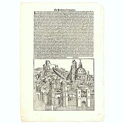
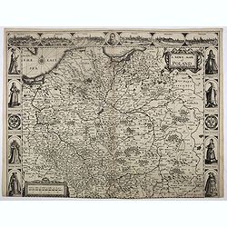
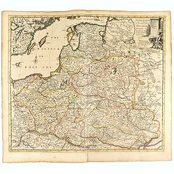
De Polonia Sarmatica - Lituania. CCLXXIX
An imaginary view of a Lithuanian or Polish City (190 x 223mm.) , however the earliest obtainable view of this period.Page from the richest illustrated Incunabula, the fa...
- $400 / ≈ €374
Place & Date: Nuremberg, 12 July 1493
![.[Germany and Poland]](/uploads/cache/33862-250x250.jpg)
.[Germany and Poland]
Wood block printed map and one of earliest printed representation of Germany, Poland, The Low Countries, Austria and Switzerland prepared by Martin Waldseemüller. Based ...
Place & Date: Vienna, Trechsel, G., 1525 -1541
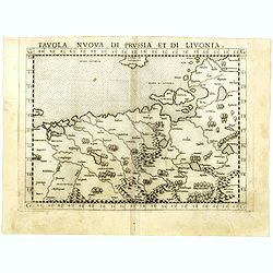
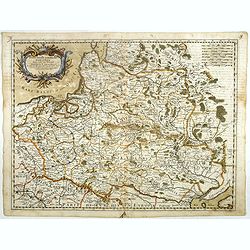
Tavola nuova di Prussia et di Livonia.
Uncommon first edition of this early map of the region from Pomerania to Livonia, includes a portion of Estonia, and coastal detail on the Baltic Sea with a small section...
- $400 / ≈ €374
Place & Date: Venice, Vincenzo Valgrisi, 1561
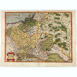
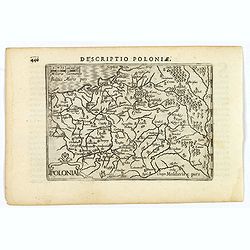
POLONIAE finitimarumque locorum descrip:tio. Auctore WENCESLAO GRODECCIO. Polono.
Ortelius' map of Poland, being a close copy of Grodecki / Pograbka's map of 1558/62 map, itself based on Wapovsky 1526 (Karrow 56) With Latin text on verso, a state 1 and...
- $1200 / ≈ €1123
Place & Date: Antwerp, 1587

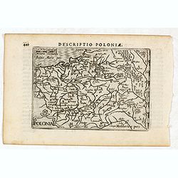
POLONIAE finitimarumque locorum descrip:tio. Auctore WENCESLAO GRODECCIO. Polono.
Ortelius' map of Poland, being a close copy of Grodecki / Pograbka's map of 1558/62 map, itself based on Wapovsky 1526 (Karrow 56) With Latin text on verso, a state 4 and...
- $1400 / ≈ €1310
Place & Date: Antwerp, 1592
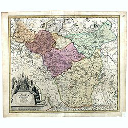
Oswiec. et Zatorien. Ducatus.
Miniature map of Poland from "Il Theatro del Mondo," which was a plagiarized version of Ortelius' pocket atlas published specifically for the Italian market by ...
- $200 / ≈ €187
Place & Date: Brescia, 1598
Polonia.
A miniature map of the Polish-Lithuanian Commonwealth, published by Petrus Bertius, in Amsterdam at the beginning of the seventeenth century. It features a small strap-wo...
Place & Date: Amsterdam, 1606
Descriptio Poloniae / Polonia.
A rare miniature map of Poland. Title cartouche on the lower left corner.First published in 1598 in his Caert-Thresoor, the plates were executed by the most famous engrav...
- $400 / ≈ €374
Place & Date: Amsterdam, Cornelis Claes, 1606

Poloniae, Lituaniaeq descriptio.
Fine general map of Poland. Rare; the second plate appearing in the post-1595 edition of the Theatrum. Only used until 1612.Based on the now-lost map of Waclaw Grodecki. ...
Place & Date: Antwerp, 1612
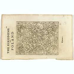
Polonia. (With text page)
Early map of Poland (168x250mm.) printed on a text page, together with another giving a description of the region in English.
- $150 / ≈ €140
Place & Date: Amsterdam, 1612
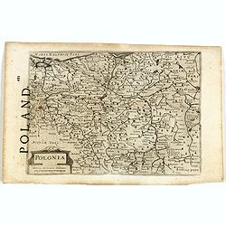
Polonia et Silesia. (With text page)
Early map of Poland. With English title above the map and an description of the region in English on verso.
- $250 / ≈ €234
Place & Date: Amsterdam, 1612

A Newe mape of Poland Done into English by I.Speede.
A wonderful map of Poland. Incorporated into Speed's 'Prospect Of The Most Famous Parts Of The World.' Includes birds-eye views of Cracow, Dantzick, Posna, Crossen, Sando...
Place & Date: London, 1627
A Newe mape of Poland Done into English by I.Speede.
A wonderful map of Poland. Incorporated into Speed's 'Prospect Of The Most Famous Parts Of The World'. Includes birds-eye views of Cracow, Dantzick, Posna, Crossen, Sando...
- $3500 / ≈ €3275
Place & Date: London, 1627

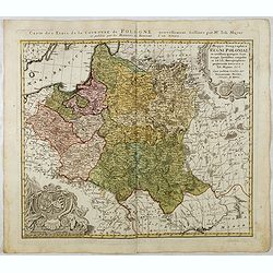
Tabula nova Poloniae et Silesiae.
Second state, dated 1630 underneath the title. A finely engraved carte á figures with cartouche representing in the four corners of the map : Kings ( on the left side Si...
Place & Date: Amsterdam, 1630

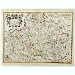
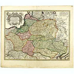
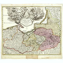
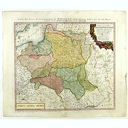
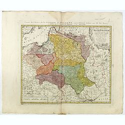
Polonia regnum et Silesia ducatus.
Very decorative map of Poland embellished with two cartouches and two coats of arms surmounted by cherubs and female figures. Showing the region from the Oder east to Pod...
Place & Date: Amsterdam, 1638
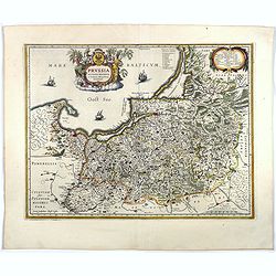
Prussia accurate descriptia a Gasparo Henneberg Erlichensi.
Prussia and the Baltic Region, with two large decorative cartouches, coat of arms, and three sailing ships. As indicated in the title cartouche, the map was prepared by t...
Place & Date: Amsterdam, 1644
Selling price: $500
Sold in 2017
Germano-Sarmatia in qua Populi maiores Venedi et Aetiaei Peucini et Bastarnae in minores Populos divisi ad hodiernam locorum et Regionum
Fine map of ancient Poland and the whole of Eastern Europe, showing part of the Baltic and Gulf of Riga, including the modern countries of Poland, Lithuania, Ukraine and ...
Place & Date: Paris, 1655
Selling price: $425
Sold in 2013
Estats De La Couronne De Pologne ou sont les Royaume de Pologne, Duches et Provinces De Prusse, Cuiave, Mazovie, Russie Noire &c.
Fine map of Poland, state with erased date. Engraved by J.Sommer.Nicolas Sanson was to bring about the rise of French cartography, although the fierce competition of the ...
Place & Date: Paris, 1663
Stati della Corona di Polonia Divisa nella sue Principali Provincie e Palatinati da Guglielmo Sansone. . .
Rare map of Poland, Lithuania and the Ukraine. Copies of his first edition of 'Mercurio Geografico', published in 1674, do not contain a map of Poland. Only added in late...
- $1250 / ≈ €1170
Place & Date: Rome, 1678

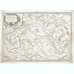
Le Cours de l'Elbe et de l'Oder où sont les Electorats de Saxe et de Brandebourg, les Duchés de Mekelbourg et de Pomeranie. . .
A detailed and scarce map showing the rivers Elbe and Oder in Germany and Poland. Dark engraving.This is one sheet of the four sheet wall map by Pierre Du Val entitled: &...
Place & Date: Paris, 1684
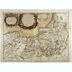
La Prussia Divisa in Reale Che Appartiene al Ré Di Polonia et in Ducale Che Spetta all'Elettore Di Brandeburgo. Da Giacomo Cantelli Da ...
In the upper left-hand corner a large title cartouche with a dedication to Cardinal Denhoff. The map is dated 1689.The cartographer was Giacomo Cantelli (1643-1695) who w...
- $1000 / ≈ €936
Place & Date: Rome, 1689
Tabula nova totius regni Poloniae. . .
Map of Poland, Lithuania, Latvia, Belarus and Ukraine with decorative cartouche in the upper left corner.Published by Nicolaas Visscher after N. Sanson.
- $900 / ≈ €842
Place & Date: Amsterdam, 1690

Ducatus Prussiae tam Polono Regiae. . .
This is a rare issue of Frederick de Wit's attractive map of the northern part of Poland, Prussia and the Baltic regions.Very decorative title cartouche, including three ...
Place & Date: Amsterdam, 1698
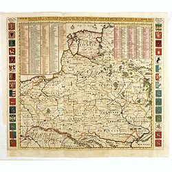
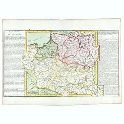
Les Estats de la Couronne de Pologne.
Lovely small map of Poland with title cartouche and a panel in the upper right corner listing local rulers.From Le Nouveau et Curieux Atlas Geographique et Historique.. b...
- $200 / ≈ €187
Place & Date: Paris, 1719
Nouvelle carte du royaume de Pologne, divisée selon..
Chatelain's map of Poland. The title is in two lines across the map. On bottom border appears an index to the map's contents. At the top of the map appear historical rema...
- $700 / ≈ €655
Place & Date: Amsterdam, 1719
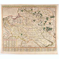
Nouvelle carte du royaume de Pologne, divisée selon..
Chatelain's map of Poland. The title is in two lines across the map. On bottom border appears an index to the map's contents. At the top of the map appear historical rema...
- $1100 / ≈ €1029
Place & Date: Amsterdam, 1719
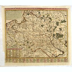
Carte De Pologne Avec La Chronologie Des Rois Et Des Ducs De Lithuanie, Ainsi Que Des Grands M. De L'Ordre Teutonique Les Evechez et Archeveches, et Les Armes Des Provinces . . .
Map of Poland with a key table to the towns, and 30 coats of arms on both sides, extending south the Black Sea. From Chatelain's monumental 7-volume "Atlas Historiqu...
- $1750 / ≈ €1638
Place & Date: Amsterdam, 1720
Regnum Borussiae gloriosis auspiciis serenissimi et potentissimi princip. Friderici III primi Borussiae regis march. et elect. Brandenburg inauguratum die 18 Jan...1701.
Map covering the region along the Baltic Sea from Prussia to northern Poland, with the city of Kaliningrad (Königsberg), Danzig, and Heilsperg, etc. With a large title-c...
- $700 / ≈ €655
Place & Date: Nuremberg, 1720
Poland and other the Countries belonging to the Crowne According to the Newest Observation 1719
Fine map of the Polish Empire in a second edition of the map, which had been published by Morden & Browne in 1710. The remnants of the earlier address, are still slig...
- $1200 / ≈ €1123
Place & Date: London, 1721
Regni Poloniae, ducatus Mazoviae et province Cujaviae / descriptio emendata per R. & I. Ottens
Very rare map of Poland Lithuania and Ukraine, etc. Engraved by A. Schut.Joachim Ottens (1663 - 1719) and his sons Renier and Joshua were prominent Dutch booksellers and ...
Place & Date: Amsterdam, 1725
Selling price: $1500
Sold in 2017

Grande Pologne et Prusse avec les frontières de la Misnie, Lusace, Moravie et Lithuanie.
Detailed map of Poland and Prussia. Published by Pieter van der Aa who published a.o. "Naauwkeurge versameling der gedenkwaardigste zee- en land-reysen", a seri...
Place & Date: Leiden, 1729
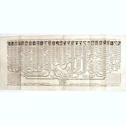
Nouvelle carte genealogique des souverains et des familles illustres aliez a la maison ou aux decendans de la famille roialle de Piaste roi de Pologne. . .
A two sheet engraving of the genealogical family tree of Poland from 804 AD to the time of publication. The tree extends throughout Europe and is headed by the arms of 30...
- $150 / ≈ €140
Place & Date: Amsterdam, 1719-1732
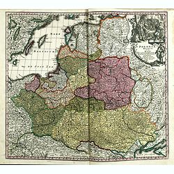
Poloniae Regnum ut et Magni Ducatus Lithuaniae . . .
Detailed map of Poland and the Baltic regions, extending in the south to Ukraine and northern Hungary.Here in its second state, now with added letters to the border scale...
- $750 / ≈ €702
Place & Date: Augsburg, 1735
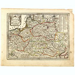
Mappa Geographica Regni Poloniae ex novissimis quotquot sunt mappis specialibus composita et al L.L. Stereographicae projectionis revocata a Tob. Mayero. . . .
Decorative map of Poland after Tobias Mayer who was based on Barnikel's map of Curland (1747) and Jan Nieprzecki's map of Lithuania (1749).Poland extends from Glogau and ...
- $600 / ≈ €561
Place & Date: Nuremberg, 1757
![Partie septentrionale du cercle de Haute Saxe [...] Brandebourg.](/uploads/cache/64110-250x250.jpg)
Partie septentrionale du cercle de Haute Saxe [...] Brandebourg.
Finely and crisply engraved map of north eastern part of Germany, including part of Poland. With inset map of Brandenburg. Map by Giles Didier Robert De Vaugondy with era...
- $150 / ≈ €140
Place & Date: Paris, c. 1760
![Partie septentrionale du cercle de Haute Saxe [...] Brandebourg.](/uploads/cache/33211-250x250.jpg)
Partie septentrionale du cercle de Haute Saxe [...] Brandebourg.
Finely and crisply engraved map of north eastern part of Germany, including part of Poland. With inset map of Brandenburg. Map by Giles Didier Robert De Vaugondy with era...
- $150 / ≈ €140
Place & Date: Paris, c. 1760
![[Mer Baltique]](/uploads/cache/37796-250x250.jpg)
[Mer Baltique]
Detailed map of Northern part of Poland with Danzig, from his "Atlas moderne ou collection de cartes...".map N° 15.
- $300 / ≈ €281
Place & Date: Paris, 1762
Royaume de Pologne.
Fine map of Lithuania, Prussia and Poland with an explicatif text to both sides. From Jean Baptiste Louis Clouet (1730-1790) influential "Géographie Moderne" f...
- $350 / ≈ €328
Place & Date: Paris, ca. 1767
Mappa Geographica Regni Poloniae ex novissimis quot quot sunt mappis. . .
A map of Poland, Lithuania and Belarus, first published in 1750 by Homann Heirs, and now re-issued in 1773. Coastline includes all between Riga and Gdansk. Map is based o...
- $500 / ≈ €468
Place & Date: Nuremberg, 1773
Mappa Geographica Regni Poloniae ex novissimis quotquot sunt mappis specialibus composita et al L.L. Stereographicae projectionis revocata a Tob. Mayero. . . .
Late Tobias Mayer detailed map Polish edition, updated in order to show the borders of the kingdom of year 1772 after the division of the territory.Mayer's map extends fr...
- $750 / ≈ €702
Place & Date: Nuremberg, 1773