Browse Listings
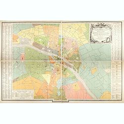
Plan des paroisses de Paris avec la distinction des parties éparses qui en dépendent dressé... par J. Junié, Ingén. Géogr. De Monseigneur l'Archeveque et géomètre des Eaux et forêts de ...
Large wall map size plan of Paris in 4 separate sheets, if joined forming a plan of Paris of 93 x 60cm. This plan is a 1904 version of a manuscript plan drawn in 1786 by ...
Place & Date: Paris, Service des Travaux historiques de la Ville de Paris, 1904
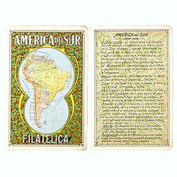
America del Sur Filatelica.
Unique manuscript map of South America. Award-winning manuscript card, prepared by Antonio Raggio for the 11th Congreso de la Union Postal Universal (World Postal Congres...
Place & Date: Buenos Aires, 1939
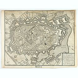
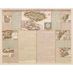
Mons the Capital City of Hainault in y Low Countries, taken by y French in 1691, Restor'd to y Spaniards by y Peace of Ryswick in 1697, retaken by y Allies in 1709, and left to y Emperor by y Treaty of Utrecht. .
An interesting copper engraved view of the walled city engraved by I. Basire, with pictographs of buildings. Many buildings and places are named on the map. Nicholas Tind...
Place & Date: London, 1743
![Le Malade Imaginaire. [Plate 48]](/uploads/cache/47424-250x250.jpg)
Le Malade Imaginaire. [Plate 48]
Illustration from the "Le Malade Imaginaire" by Félix Lorioux . This plate 48 has a caption that roughly translates as: "I hear some great news", Mr ...
Place & Date: Paris, ca. 1900
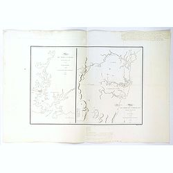
(Sheet X with Puk Bay from) General Tableau zur Karte von Alt Ost und West Preussen nebst dem aufgenommenen Trigonometrischen Netz. . .
Sheet IV with Zalew Wislany and the towns of Elblag, Paslek, Braniewo, etc of this important multi sheet map of Prussia, Lithuania and Poland.The rare first edition of th...
Place & Date: Berlin, 1802-1810
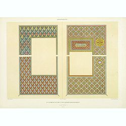
Arabesques. - Ornementation d'un Qoran Mauresque (XVIIIe siècle)
Lithographed by Daumont. From the author's "L'Art Arabe d'après les monuments du Kaire…". Emile Prisse d'Avennes, Orientalist and Muslim convert, obsessive i...
Place & Date: Paris, 1877
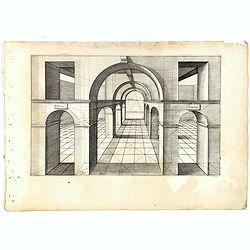
Perspective print by Vredeman de Vries. 16.
Engraving from Perspective, c'est a dire, le tresrenomme art du poinct oculaire d'une veue dedans ou travers regardante, estant sur une muraille unie, sur un tableau, ou ...
Place & Date: The Hague, 1604 - 1605
L'Empire de Russie en Europe et Asie Divisee en ses differents provinces par Lamarche.
Very rare map of Russia. The map was included in the never finished project for the atlas of the so called "Società Calcografia", published by the two main Ven...
Place & Date: Venise, Società Calcografia, 1803

Workers - Hu Xian Peasant Painting.
Published by Shanghai renmin chubanshe (上海人民出版社). A fine Chinese propaganda poster at the tim...
Place & Date: Shanghai, September, 1974 - variant 1975
Tabula Ducatus Brabantiae continens Marchionatum Sacri Imperii et Dominium Mechliniense emendate à F. de Wit 1666
Shows present-day Belgium and Dutch province of Brabant. Including the Maas and Waal rivers. Shows Antwerp, Brussels, Namur, Liege and Venlo among other towns and cities....
Place & Date: Amsterdam, 1680
Selling price: $25
Sold in 2016
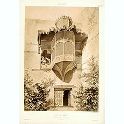
Beyt El-Emyr.
Lithograph by Mouilleron representing a young woman looking over a beautiful moucharabieh. From the author's "L'Art Arabe d'après les monuments du Kaire?". Emi...
Place & Date: Paris, 1877
![Le Malade Imaginaire. [Plate 61]](/uploads/cache/47425-250x250.jpg)
Le Malade Imaginaire. [Plate 61]
Humorous illustration from the "Le Malade Imaginaire" by Félix Lorioux. This Plate 61 has a caption that reads: "A doctor, having posed a question to Arga...
Place & Date: Paris, ca. 1900
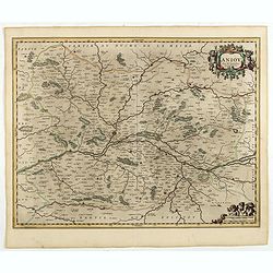
Aniou. . .
Decorative map centered on the Loire valley. Fine title cartouche in upper right corner.
Place & Date: Amsterdam, 1650
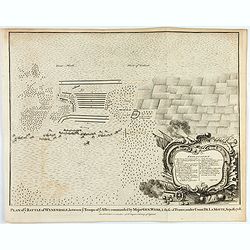
Plan of ye Battle of Wynendale between ye Troops of ye Allies commanded by Major Gen. Webb & those of France under Count de La Motte Sept. 28 1708.
An interesting copper engraved battle plan of Pinedale during the War of the Spanish Succession, showing the position of General Webb's troops in order to protect an alli...
Place & Date: London, 1743
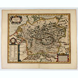
Germaniae Veteris typus.
Map made on the basis of the writings by the ancient authors Tacitus, Caesar, Dionysus, Ptolemy, Suetonius, Eutropius, Seneca, Plinius and Strabo.Showing an substantial p...
Place & Date: Amsterdam, 1650
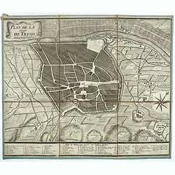
Plan de la ville de Treves.
Very rare town-plan of Trier by Didier Bugnon (1676-1736), geographer of the Duke of Lorraine. With numbered key (1-57) of the main buildings and buildings of the city. T...
Place & Date: Paris?, 1720
Vue perspective de la Ville et Forteresse Electorale de Koningstein, et de la Montagne de Lilienstein avec ses environs du côté du Couchant, dépendant des Etats de Saxe, appartenant à Sa Majesté le Roy de Pologne.
Perspective view of Königstein fortress, situated near to Dresden in Saxony. To the left the Fortress and in the foreground the river Elbe. The castle was inhabited by A...
Place & Date: Paris, 1760
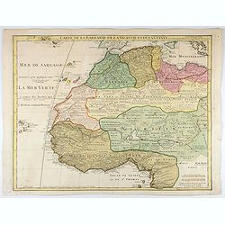
Carte de La Barbarie de La Nigritie et de la Guinée.
A detailed engraved map of north west Africa including the Canary and Cape Verde Islands. Engraved by Inselin. Address and date changed, now with the imprint "A Pari...
Place & Date: Paris, 1781
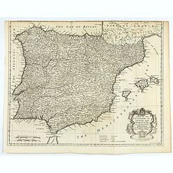
A mapof the Kingdom of Spain and Portugal from the latest & best Observations. . .
An interesting copper engraved map of Spain and Portugal, with an attractive rococo cartouche. Nicholas Tindal (1687-1774) / Paul de Rapin (1661-1725) were responsible fo...
Place & Date: London, 1743
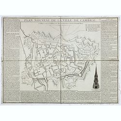
Plan nouveau de la ville de Cambrai.
Nice town-plan of Cambrai, with its fortifications and the citadel, decorated with the cathedral in lower right corner. The borders contain a historical description of th...
Place & Date: Cambrai, 1814
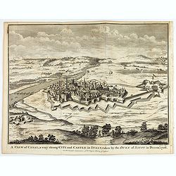
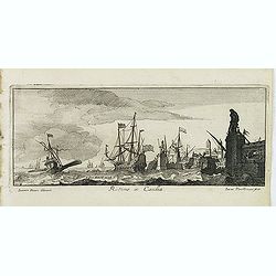
A view of Cassel, a very strong city in Italy, taken by the Duke of Savoy in Decem.r 1706
An interesting copper engraved plan of the Fortification of Cassel in Italy, with an attractive rococo cartouche, showing an overview of the battlefield and surrounding a...
Place & Date: London, 1743
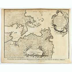
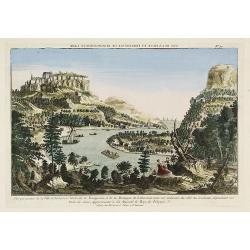
Plan of the Attack of Camaret Bay, on the coast of Bretagne, thro which lies the Harbour of Brest.
An interesting copper engraved plan of the Fortification of Camaret in Bretagne (France), with an attractive rococo cartouche, showing an overview of the battlefield and ...
Place & Date: London, 1743
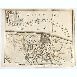
Plan of the Investiture of Ostend Surrenderd, 6 July, 1706
An interesting copper engraved plan of the Fortification of Doway in Flanders, with an attractive rococo cartouche, showing an overview of the battlefield and surrounding...
Place & Date: London, 1743
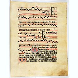
Leaf on vellum from a antiphonary.
A leaf from a Medieval Antiphonal or Choir Missal for Spanish use, in Latin on extremely heavy vellum. Justification: 360x246mm. Text is in Spanish rounded gothic hand (R...
Place & Date: Sevilla, ca.1520

(Art déco gouache)
Outstanding "art deco" gouache (unsigned) from the workshop of "Robert Pichon. Ateliers de Dessin et Lithographie – 10, rue Rochechouart – Paris. The g...
Place & Date: Paris, ca. 1930
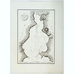
![Plan de Mons ville capitale du comté de Haynaut. [MONS]](/uploads/cache/39799-250x250.jpg)
Plan de Mons ville capitale du comté de Haynaut. [MONS]
Charming little plan of the city of Mons in Belgium, engraved by Inselin, with a lettered key (A-V) in lower right corner.
Place & Date: Paris, 1750
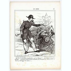
En Chine.
From the series "Caricatures du Prussien - Guerre des Duchés". Lithographed by Julés Pelcoq.
Place & Date: Paris, 1864
![[Title page] Atlas Coelestis in mundus spectabilis, et in eodem Stellarum](/uploads/cache/47437-250x250.jpg)
[Title page] Atlas Coelestis in mundus spectabilis, et in eodem Stellarum
Title page from the first edition of this celestial atlas.
Place & Date: Nuremberg 1742
![[Les anciennes provinces Françaises à la ville de Saint Denis].](/uploads/cache/41681-250x250.jpg)
[Les anciennes provinces Françaises à la ville de Saint Denis].
Nine small chromolithography's trade cards for Ville de Saint Denis, each with French regions and places, with description in French on each verso.Cards of the regions : ...
Place & Date: Paris, circa 1900
![Le Malade Imaginaire. [Plate 6]](/uploads/cache/47426-250x250.jpg)
Le Malade Imaginaire. [Plate 6]
Humorous illustration from the "Le Malade Imaginaire" by Félix Lorioux . This plate 6 has a caption that roughly translates "There was not a day when Arga...
Place & Date: Paris, ca. 1900
![[ A set of four humorous illustrations 'Le Malade Imaginaire'.]](/uploads/cache/46323-250x250.jpg)
[ A set of four humorous illustrations 'Le Malade Imaginaire'.]
A humorous illustration from the "Le Malade Imaginaire" - numbers 68. Shows a smiling, frothing syringe, with hands-on hips surrounded by dancing witches. Small...
Place & Date: Paris, ca. 1880

Karsten Niebuhr.
Stipple engraved portrait of Carsten Niebuhr or Karsten Niebuhr (1733 – 1815), published in F. J. Bertuch "Allgemeine geographische Ephemeriden".Niebuhr was a...
Place & Date: Weimar, 1810
![[Les anciennes provinces Françaises à la ville de Saint Denis].](/uploads/cache/41684-250x250.jpg)
[Les anciennes provinces Françaises à la ville de Saint Denis].
Nine small chromolithography's trade cards for Ville de Saint Denis, each with French regions and places, with description in French on each verso.Cards of the regions : ...
Place & Date: Paris, circa 1900
![[Les anciennes provinces Françaises à la ville de Saint Denis].](/uploads/cache/41683-250x250.jpg)
[Les anciennes provinces Françaises à la ville de Saint Denis].
Nine small chromolithography trade cards for Ville de Saint-Denis, each with French regions and places, with description in French on each verso.Cards of the regions: Lor...
Place & Date: Paris, circa 1900
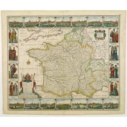
Gallia. Nova Galliae descriptio . . .
Very rare and early map of France with figures on three sides with views of cities, portraits (Henri IV and Marie de Medicis) and costumes. The map was directly influence...
Place & Date: Amsterdam, 1616
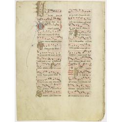
Leaf on vellum from an antiphonary.
A more than 600 years old antiphonary leaf, written in Besancon, in 1370. Musical notation on 4 bars, the staves are in red and the notes in black: numerous pen-flourishe...
Place & Date: Besançon, 1370

(Art déco gouache)
Outstanding "art deco" gouache (unsigned) from the workshop of "Robert Pichon. Ateliers de Dessin et Lithographie – 10, rue Rochechouart – Paris. The g...
Place & Date: Paris, ca. 1930
Retimo in Candia. (Rethymno)
Magnificent panoramic of Rethymno on Crete. Engraved by Lucas Vostermans II, who was born in 1624, in the same year when the family moved to England for six years. He wa...
Place & Date: Antwerp, c.1690
Selling price: $160
Sold in 2011
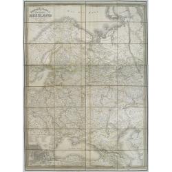
General karte vom europaischen Russland.
Rare second edition of a lithographed wall map of the European part of the Russian empire, at a scale of about 1:3,200,000. With the title in a elaborately decorated lett...
Place & Date: Weimar, Geographisches Institut, 1840

Leaf on vellum from a antiphonary.
A leaf from a Medieval Antiphonal or Choir Missal for Spanish use, in Latin on extremely heavy vellum. Justification: 360x246mm. Text is in Spanish rounded gothic hand (R...
Place & Date: Sevilla, ca.1520
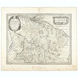
Ducatus Luneburgensis
Very detailed map centered on Albis river and the cities of Hamburg and Lunburg to the north. Also showing Bremen.
Place & Date: Amsterdam, 1629-1630

Porte du Palais du Soultan Beybars. (XIIIe. siècle)
Highly decorative lithography by Ch. Fichot, showing the walled-up entrance of Sultan Beybars' palace. From the author's "L'Art Arabe d'après les monuments du Kaire...
Place & Date: Paris, 1877
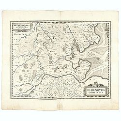
Oldenburg Comitatus
A map of the northern part of Germany centered on Oldenburg. Also showing Bremen. North to the right. The decoration consists with a windrose and a title cartouche surmou...
Place & Date: Amsterdam, 1629-1630
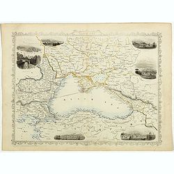
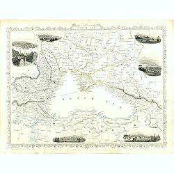
Black Sea.
Decorative steel engraved map of the Black Sea with inset views of Sebastopol and Odessa. There are also vignettes of Constantinople, Sinope and Varna. Taken from "T...
Place & Date: London, London Printing and publishing Company of London, ca. 1851
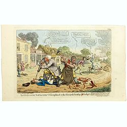
Anti-dandy infantry triumphant or the velocipede cavalry unhobby'd. (pl 353)
Scene on a high-road passing through a village. Those who see their livelihood threatened by mechanical transport attack the riders of velocipedes. In the foreground a di...
Place & Date: London, 1819

Indian painting on paper of a couple in a love-making position.
Fine miniature, presenting a couple in a love-making position, set on a balcony with in a landscape in the background. The miniature was painted in India in the late 19th...
Place & Date: India, ca. 1900
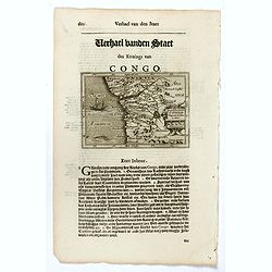
Congo Regnum Christian. In Africa.
Small map illustrating the western seashores of Central Africa, surrounded by text in Dutch.Nicolaes de Clerck (de Klerc) was active as engraver and publisher in Delft fr...
Place & Date: Amsterdam, Cloppenburch, 1621
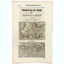
Abissinorum Imperium. / Acomath .I. Turcarum Imperator .XIIX. Ex Stirp. Ottomannica.
Map of central Africa. Copperplate engraving on text leaf with letterpress on verso. The engraving depicts a half length oval portrait of "Acomath I".Nicolaes d...
Place & Date: Amsterdam, Cloppenburch, 1621
Black Sea.
Decorative steel engraved map of the Black Sea with inset views of Sebastopol and Odessa. There are also vignettes of Constantinople, Sinope and Varna. Taken from "T...
Place & Date: London, London Printing and publishing Company of London, ca. 1851
![Oceanie. [Manuscript on paper]](/uploads/cache/01830-250x250.jpg)
Oceanie. [Manuscript on paper]
Decorative manuscript map on paper covering South East Asia, Australia and New Zealand.
Place & Date: France ?, ca. 1850
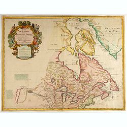
Carte du Canada ou de la Nouvelle France.
Fourth state of the map of Canada published by Delisle with the imprint "sur le Quai de l’Horloge a l’Aigle d’Or avec Privilege pour 20 ans, 1703". Beneat...
Place & Date: Paris, 1703
Nova Haec tabula Galliae. . .
Dated 1660. This handsome map of France is dedicated to Louis XIV, interesting in light of the nearly constant warfare between Louis and the Netherlands in the ensuing ye...
Place & Date: Amsterdam, 1660
![Noweav Mexiqve [California as an Island]](/uploads/cache/03796-250x250.jpg)
Noweav Mexiqve [California as an Island]
Uncommon miniature map of California as a island, from Pierre Duval's La Geographie Universeille in a second state. The map is derived from Audience de Guadalajara (1657)...
Place & Date: Paris, 1663
Mexique ou Nouvelle Espagne.
Attractive copper engraving, depicting Mexico with Central America.From the French text edition of Description d'Univers, 1683. by Allain Manneson Mallet (1630-1706), a w...
Place & Date: Paris, 1683
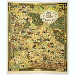
US ZONE. Bavaria, Hesse, Wurtemberg, Baden.
An unusual decorative pictorial map, from the years immediately following World War II, depicting the American Zone of Occupation in southern Germany. It portrays rural ...
Place & Date: Munich, 1940
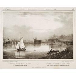
Pierpont's distillery on Long Island.
Decorative print after Jacques Milbert, and lithographed by Sabatier and the figures by Victor Adam.From Amérique Septentrionale. Printed by E.Ardit, Rue Vivienne, Paris...
Place & Date: Paris, 1829
![Nova & exacta Chorographia Latii sive Territorii Romani iuxta veterem et novum situm parallela nomimu[m] comparatione elaborata.](/uploads/cache/44863-250x250.jpg)
Nova & exacta Chorographia Latii sive Territorii Romani iuxta veterem et novum situm parallela nomimu[m] comparatione elaborata.
Map of central Italy, centered on Rome from "Latium" by A. Kircher and designed by Innocenzo Mattei. The title cartouche in the lower right, small legend with 1...
Place & Date: Amsterdam, 1671
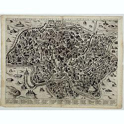
Antiquae urbis perfecta et Nova delineatio. [ Ancient Rome)
First state before imprint of Jacobus de Rubeis. A rare view of Ancient Rome from the Lafreri-School in the style of Ambrogio Brambilla's view of about 1575.
Place & Date: Rome, ca. 1600
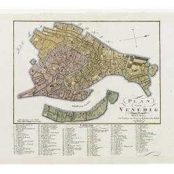
Plan von Venedig.
An uncommon and finely rendered town-plan of Venice. The work is highly detailed and provides a 133 point legend identifying the town's key sites and places of import.
Place & Date: Weimar, 1807
Carte qui contient..Iles & Terres..L'Amerique..Jamaique..
Eight maps on one sheet. From Chatelain's Atlas Historique et Méthodique . Including maps of Bermuda, Jamaica, New England with Long Island, Carolina, Chesapeake and Del...
Place & Date: Amsterdam, 1728
L'Utrecht. . .
Although not renowned for the originality of his work, Pieter van der Aa is highly thought of for the design and quality of his output. Showing Dutch province of Utrecht....
Place & Date: Amsterdam, 1713

Nova Virginiae tabula.
A fine example of Blaeu's map of Virginia and the Chesapeake region is based on the first state of Smith's map, 1612, and is slightly larger and more expertly engraved.Th...
Place & Date: Amsterdam, 1635/1660

Plan de L'Isle de Paque / Plan de la Baie de Cook.
Two engraved maps and four coastal profiles of Easter Island in the Pacific. First published in the Atlas du Voyage de la Perouse. This is the edition of the extremely ra...
Place & Date: Paris, 1797-1807
Carte de la Baie des Chiens-Marins (Shark's Bay de Dampier). . .
A strikingly detailed chart of a portion of the coastline of Western Australia, titled 'Carte de la Baie des Chiens-Marins, which was also explored by William Dampier. Th...
Place & Date: Paris, 1807
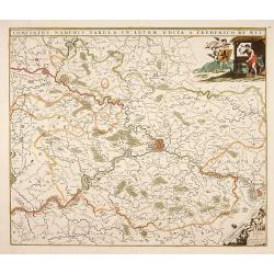
Comitatus Namurci Tabula in Lucem. . .
Centered on Namen, with decorative title cartouche upper right.
Place & Date: Amsterdam, 1680
Plan du Port Jackson / Plan du Comte de Cumberland.
Two maps on one sheet showing the earliest scientific surveys of Port Jackson and the area surrounding Sydney Harbour, undertaken by the French in 1802. This is the editi...
Place & Date: Paris, 1807
Plan du Port du Nord de la Baie de la Recherche.
A French maritime chart of the plan of the northern portion of Recherche Bay on the S.E. tip of Tasmania. The chart has some physical detail, outlining trees and hills, b...
Place & Date: Paris, ca 1807

Plan du Port du Sud de la Baie de la Recherche / Croquis de la Baie des Moules. . .
A French maritime charts of the Port du Sud in Research Bay and the mouth of the Bay of Mussels, both in southern Tasmania. This is the edition of the extremely rare atla...
Place & Date: Paris, ca 1807

Campanule gantelée. - Campanule trachaelium L.
Bouquet of poppy flowers, engraved by P.F. Le Grand after designs by the Dutch born Gerard van Spaendonck (1746-1822).Taken from the rare work "Fleurs dessinées d'a...
Place & Date: Paris, c.1800
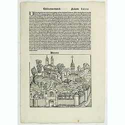
Quita Etas Mundi. Folium.LXVIII (Verona)
The Latin text page is illustrated with an imaginary of Verona, Italy. VERSO are portraits of poets and teachers.Page from the richest illustrated Incunable, the famous:...
Place & Date: Nuremberg, 12 July 1493

Plan de la Baie de L'Adventure. . .
A French maritime chart of Adventure Bay in S.E. Tasmania. Adventure Bay is the name of both a township and a geographical feature on the eastern side of Bruny Island. Th...
Place & Date: Paris, ca 1807
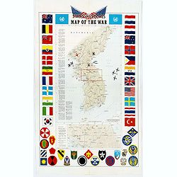
Pacific Stars and Strips Map of the War.
A detailed map of the Korean War. Several silhouetted flying military aircraft are shown in formation. The map shows the Korean Peninsula from its northern border with Ru...
Place & Date: America, 1953
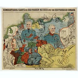
Humoristische Karte von Europa im Jahre 1914.
A satirical map of Europe with a title in German that marks the outbreak of the First World War, probably conceived between August and October 1914. Lehmann-Dumont was no...
Place & Date: Dresde, Leutert & Schneidewind, ca. 1914
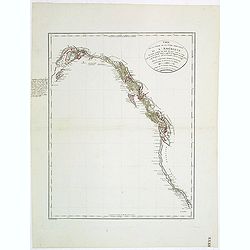
Carte de la partie de la cote nord-ouest de l'Amerique. Reconnue pendant les Etes de 1792, 1793 et 1794 depuis 29054' de latitude nord et 244033' de. . .
Detailed and rare map of the Gulf of Alaska, British Columbia, south to St.Francisco.Prepared by Edward Roberts after information by George Vancouver. Engraved by Tardieu...
Place & Date: Paris, 1820
Selling price: $150
Sold in 2011

Tabula ducatus Limburch et comitatus Valckenburch. . .
The map describes the southern part of Limburg and reaches into Belgium (Liege, Verviers) and Germany. With two very decorative cartouches.
Place & Date: Amsterdam, 1690
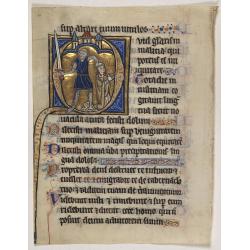
Illuminated leaf from a Psalter.
Very fine 20 lines illuminated leaf from a liturgical Psalter in Latin with the reading from the Vulgate Bible. Lines in a slightly irregular gothic hand, black ink, plum...
Place & Date: Flanders, Rhineland, or possibly England, c. 1280
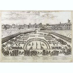
Comparse des Cinq Quadrilles dans l'Amphitheatre.
An early and intriguing engraving recording one of the most celebrated and spectacular festivals held at Paris by the young Louis XIV. The multi-day tournament took place...
Place & Date: Paris, imprimerie royale, 1670

Belgium Foederatum emendate auctum et novissimé editum.
Fine detailed map of the area of the modern Netherlands less the southern part of Limburg. Title cartouche representing the commerce, the arts and the sciences. The Lion ...
Place & Date: Amsterdam, 1680
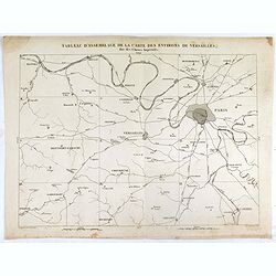
Tableau d'assemblage de la carte des environs de Versailles dite chasses impériales.
Key sheet to the rare 12 sheet map "Carte topographique des environs de Versailles dite des Chasses Impériales, levée et dressée de 1764 à 1773 par les ingénieu...
Place & Date: Paris, ca. 1820
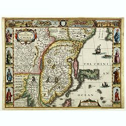
The Kingdome of China.
A most sought-after map of China. Decorative border vignettes including views of the cities of Quinzay and Macao along the top border with the wheeled wind machines and p...
Place & Date: London, G. Humble, 1626