Browse Listings in Europe > France > France Cities
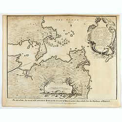
Plan of the Attack of Camaret Bay, on the coast of Bretagne, thro which lies the Harbour of Brest.
An interesting copper engraved plan of the Fortification of Camaret in Bretagne (France), with an attractive rococo cartouche, showing an overview of the battlefield and ...
Date: London, 1743
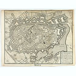
Mons the Capital City of Hainault in y Low Countries, taken by y French in 1691, Restor'd to y Spaniards by y Peace of Ryswick in 1697, retaken by y Allies in 1709, and left to y Emperor by y Treaty of Utrecht. .
An interesting copper engraved view of the walled city engraved by I. Basire, with pictographs of buildings. Many buildings and places are named on the map. Nicholas Tind...
Date: London, 1743
![Chambery / Turo / Coucy le Chateau. . . [5 prints]](/uploads/cache/14386-250x250.jpg)
Chambery / Turo / Coucy le Chateau. . . [5 prints]
A set of 5 prints. A nice view of Chambery: in Savoie; a charming view of Coucy le Chateau, engraved by Picquenot; a very fine plan of Tours, including a lettered key on ...
Date: Paris, 1580 -1750

Vue et perspective de la ville de Marseille et ses environs, prise du côté de la belle vue de la plaine St. Michel. Dediée à S. A. S. Mgr. le duc de Penthievre Grand Amiral de France. Par son très humble et très obéissant Serviteur Aulagnier.
Scarce large and spectacular panorama of the city and harbour of Marseille published in Paris in the middle of the 18th century. Engraved by Pierre Jacques Duret under th...
Date: Paris, 1751

Vue d'un Feu d'Artifice tiré devant l'Hotel de Ville en réjouissance de la Paix.
Optical view, illustrating a fireworks display in front of the Paris city hall.In the eighteenth and nineteenth centuries there were many popular speciality establishment...
Date: Paris 1760

Veuë et Pers-pective de l'Entrée du Château de Marly en général.
A rare panoramic view of the Château de Marly (Marly-le-Roi) by Aveline. The plate, at the joint address of Esnault et Rapilly and Daumont, is numbered in upper right co...
- $250 / ≈ €215
Date: Paris, c. 1760

Plan général de Reims et de ses Environs Dédié au Roi.
Rare wall map of a plan of Reims engraved by Jean Lattré. Central cartouche included in the lower border, composed of the coat of arms of France and Navarre, surmounted ...
- $2500 / ≈ €2153
Date: Paris, Lattré, 1769
Plan perspective de l'École royale militaire.
A decorative bird's eye view of the complex of the French military school in Paris, 1777, showing all grounds and buildings of the 'Ecole Royale Militaire', drawn 'd'apr�...
- $250 / ≈ €215
Date: Paris, 1778

Vue Perspective de la Place des Victoires
So-called optical print of la Place des Victoires in Paris. Therefore the image is reversed or mirror-image. One of the well-known publishers of optical prints, establish...
- $100 / ≈ €86
Date: Paris, 1780
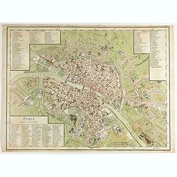
Paris Superficie 5,280,000 Toises.
FIRST EDITION of this finely engraved plan of Paris by P. F. Tardieu and prepared by DuBuisson. This detailed plan of Paris includes la Place Louis XV, la Bastille, but d...
- $600 / ≈ €517
Date: Paris, 1779-1782

Nouveau plan routier de la ville et faubourgs de Paris. 1791
Plan quadrillé en segments, entoilé. De part et d'autre "Table alphabétique des rues". Plan mis à jour auquel on a ajouté dans un cartouche en bas : un pla...
Date: Paris, 1791
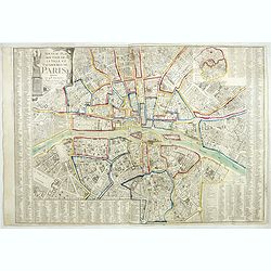
Nouveau plan routier de la ville de Paris.
Detailed plan of Paris. There is a street index down both margins and a list of theatres and public libraries. The plan now shows Place de la Révolution, Place des Pique...
- $1000 / ≈ €861
Date: Paris, 1793

Piano di Nizza.
Rare 1797 manuscript map of Nice, with the French navy attacking from the sea. Unknown author, Italian, but map attributed to an original, probably broadsheet map by Moll...
Date: Italy, after 1797

Tableau figuratif de la Chambre de Députés . . .
Figurative table of the Chamber of Deputies for the session of 1821. Showing as accurately as possible the place usually occupied by each of its members.
Date: Paris, ca. 1821
Nouveau Plan Géométral de la Ville de Lyon, Avec ses projets d'agrandissement & d'embellissement, Divisé par Arrondissements;
Large map of Lyon with, at the bottom left, a large inset depicting "The surroundings of Lyon, according to Cassini" and at the bottom right, a double table of ...
Date: Lyon, Chez Vegezzy, M.d d'Estampes,1826

Nouveau Plan Routier de la Ville et Faubourgs de Paris // Avec ses principaux Edifices et Nouvelles Barrieres.
Decorative large-scale wall map of Paris, published by M. P|chon in Paris and engraved by Michel Glot. The plan is framed by a floral border and there are 27 Parisian vie...
Date: Paris, 1834
Quartier de Tivoli Nouveaux pereements de Rues.
Plan of the center of Paris showing Tivoli district with Madalene and Clichy. Lithography and pen and ink. Drawn in are the planned workshop of Serrurerie Théophile Mign...
Date: Paris, ca.1835

ÉGLISE SAINT OUEN, A ROUEN. Dessiné d'après nature par Chapuy. Lith. par Deroy.
Original lithograph of Saint Ouen cathedral, situated in Rouen. Lithographed by Deroy after a design by Chapuy and printed in Paris by Lemercier, Bernard Cie.
- $125 / ≈ €108
Date: Paris, 1844

FACADE DE LA CATHÉDRALE A CHARTRES. Dessiné d'après nature par Chapuy. Lith. par Deroy.
Original lithograph of Chartres Cathedral's facade. Lithographed by Deroy after a design by Chapuy and printed in Paris by Lemercier, Bernard Cie.
- $125 / ≈ €108
Date: Paris, 1844

INTERIEUR DE L'EGLISE SAINT OUEN A ROUEN. Dessiné d'après nature par Chapuy. Lith. Par Arnout. Fig par Bayot.
Original lithograph of the inside of Saint Ouen chruch, situated in Rouen. Lithographed by Arnout and Adolphe-Jean-Baptist Bayot (Alessandria 1810 - 1866) after a design ...
- $50 / ≈ €43
Date: Paris, 1844

ÉGLISE St. VINCENT A ROUEN. Dessiné d'après nature par Chapuy. Lith. par Monthelier. Fig. par Bayot.
Original lithograph of St Vincent cathedral, situated in Rouen. Lithographed by Jules Monthelier (1801-1883) and Adolphe-Jean-Baptist Bayot (Alessandria 1810 - 1866) afte...
- $80 / ≈ €69
Date: Paris, 1844

TOMBEAU DU DUC DE BREZE, DANS LA CATHEDRALE DE ROUEN. Dessiné d'après nature par Chapuy. Lith. par Monthelier. Fig. par Bayot.
Original lithography of the tomb of the duke of Brézé, in the cathedral of Rouen. Lithographed by Jules Monthelier (1801-1883) and Adolphe-Jean-Baptist Bayot (Alessandr...
- $50 / ≈ €43
Date: Paris, 1844

INTERIEUR DE LA CATHEDRALE A CHARTRES. Dessiné d'après nature par Chapuy. Lith. Par Bachelier.
Original lithograph of the inside of the cathedral situated in Chartres. Lithographed by Bachelier after a design by Chapuy and printed in Paris by Lemercier, Bernard Cie...
- $50 / ≈ €43
Date: Paris, 1844

PALAIS DE JUSTICE A ROUEN. Dessiné d'après nature par Chapuy. Lith. par Rouargue.
Original lithograph of the courthouse of justice in Rouen. Lithographed by Rouargue after a design by Chapuy and printed in Paris by Lemercier, Bernard Cie.
- $150 / ≈ €129
Date: Paris, 1844

ARC DE TRIOMPHE A ORANGE. Dessiné d'après nature par Guesdon. Lith. par Ad. Cuvellier. Fig. par Bayot.
Original lithograph of the Triumph Arc of Orange. Lithographed by A. Cuvillier and Adolphe-Jean-Baptist Bayot (Alessandria 1810 - 1866) after a design by Chapuy and print...
- $100 / ≈ €86
Date: Paris, 1844

PORTAIL SEPTENTRIONAL DE LA CATHÉDRALE A CHARTRES. Dessiné d'après nature par Monthelier. Lith. par Monthelier.fig. par Bayot.
Original lithograph of the northern portal of Chartres cathedral. Lithographed by Jules Monthelier (1801-1883) and Adolphe-Jean-Baptist Bayot (Alessandria 1810 - 1866) af...
- $75 / ≈ €65
Date: Paris, 1844

COMMERCY, Vue prise de la Garenne - Chemins de fer de l'Est. Dessiné d'après nat. et Lith. par A.Maugendre.
Original lithograph eye-bird view of Commercy, as seen from La Garenne. Lithographed by Jules Monthelier (1801-1883) and Adolphe-Jean-Baptist Bayot (Alessandria 1810 - 18...
Date: Paris, 1844

Optique de St.Cloud.
This perspective view of St. Cloud comprises 6 hand colored images of the grand Bassin d'Apollon viewed through an square and two round holes cut out from the front card ...
Date: Paris, ca.1845
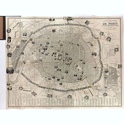
Nouveau plan illustré de la ville de Paris . . .
Fine plan of Paris, engraved by Taylor. "With the complete system of its fortifications and strong detached". Adorned with many vignettes engraved with monument...
- $900 / ≈ €775
Date: Paris, 1847

La Porte de S. Martin 24 Juin 3 heures du matin.
A view of St. Martin a well known place in Paris, by the French draughtsman André Durand.
- $100 / ≈ €86
Date: Paris, 1848

Nice Vue prise audessus de Montalban.
Beautiful view of Nice from the book "l'Italie à vol d'oiseau".
Date: Paris, 1850

Plan du territoire de Marseille dressé d'après les documens obtenus des diverses administrations.
First edition of "Plan du territoire de Marseille", drawn by Mittenhoff, a surveyor, and lithographed by Raibaud. Scale 1:30,000. The map includes a legend with...
Date: Marseille, Chiesa éditeur, Rue Canebière, 1852

Tableau synoptique de la circulation des omnibus à correspondances de Paris.
Synoptic table of the circulation of omnibuses with connections of Paris indicating at first sight the resources presented by the one hundred and sixty-seven connections ...
- $750 / ≈ €646
Date: Paris, ca. 1854

Souvenir de Paris.
Decorative bird's-eye view of the current Louvre Museum, with river Seine and the Notre Dame cathedral on the right. of Paris. After a design by P. St. Martin.
Date: Paris, ca. 1858

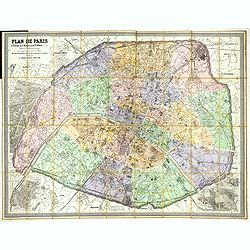
Société de la Charité Maternelle à Paris. Plan de le ville de Paris, Divisé par Quartiers avec Nomenclature.
>Rare atlas de Paris dressé par E. Devrainne, divisé en 80 quartiers et colorié par Le Roux (Le Roux pinxit). Illustré d'une page de titre aux armes de Paris avec ...
Date: Imprimerie Mercier, Clichy, 1876
Plan de Paris A l'Echelle de 2 Millim. pour 2.5 Metres . . . Indiquant les Nouveaux percements et les changements de mons de Voies publiques Avec Plans Supplmentaries Pour Les Bois De Boulogne et De Vicennes . . .
Magnificent map of the urban redevelopments planned for Paris at the end of the 19th century. The map has been updated, with insets showing supplemental plans for the Boi...
- $600 / ≈ €517
Date: Paris, 1878
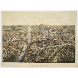
Angers 1878.
Large bird's-eye view of Angers after Mollay and lithographed by Muller.
- $250 / ≈ €215
Date: Paris, Lemercier, ca. 1878
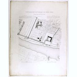
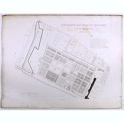
Topographie historique du vieux Paris / Plan de restitution Feuille V.
Copper engraved plan centered on Louvre by Jean-Joseph Sulpis (1826–1911) after a model by Adolphe Berty. Plate 5 from "Topographie historique du vieux Paris"...
Date: Paris, 1866-1897
Topographie historique du vieux Paris / Plan de restitution Feuille V bis.
Copper engraved plan centered on gardens of the Louvre by Jean-Joseph Sulpis (1826–1911) after a model by Adolphe Berty. Plate 5bis from "Topographie historique du...
Date: Paris, 1866-1897
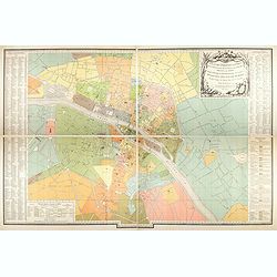
Plan des paroisses de Paris avec la distinction des parties éparses qui en dépendent dressé... par J. Junié, Ingén. Géogr. De Monseigneur l'Archeveque et géomètre des Eaux et forêts de ...
Large wall map size plan of Paris in 4 separate sheets, if joined forming a plan of Paris of 93 x 60cm. This plan is a 1904 version of a manuscript plan drawn in 1786 by ...
Date: Paris, Service des Travaux historiques de la Ville de Paris, 1904

Femme de Barèges (106, La Gascogne).
Plate published in "Les costumes régionaux de France" with illustrations by Gratiane de Gardilanne (painter and designer) and Elisabeth Whitney Moffat.Costume ...
Date: Paris, Editions du Pégase, 1929

Laitière Bordelaise, d'après de Gallard (110, La Guyenne).
Plate published in "Les costumes régionaux de France" with illustrations by Gratiane de Gardilanne (painter and designer) and Elisabeth Whitney Moffat.Costume ...
- $75 / ≈ €65
Date: Paris, Editions du Pégase, 1929

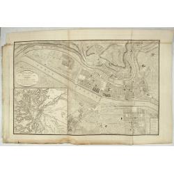
Forteresse Ile Ste Marguerite.
Nice drawing of a stronghold Ste Marguerite. The Île Sainte-Marguerite is the largest of the Lérins Islands, about half a mile off shore from the French Riviera town of...
Date: France, Provence, after 1960
