Browse Listings in Europe

Carte nouvelle de Moscovie represente la partie Septentrionale dressée par G.De L'Isle. . .
Uncommon map covering the area north of Moscow, including Lapland. Prepared by G. de L'Isle.Joachim Ottens (1663 - 1719) and his sons Renier and Joshua were prominent Dut...
Date: Amsterdam, 1720
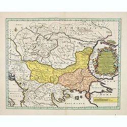
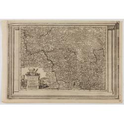
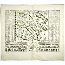
Illyricum Orientis In quo Partes II. Moesia et Thracia. Provinciae XI.
Attractive historical map of the area west of the Black Sea, today's Bulgaria, Rumania, etc. Based on the cartography of Nicolas Sanson and published by Covens and Mortie...
Date: Amsterdam, c. 1720
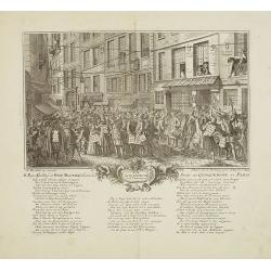
Rue Quinquempoix en l'année 1720. De regte afbeelding der wind negotie gehouden in de straat van Quinquempoix tot Parys.
A true picture of the wind trade of the rue Quinquempoix, Paris, in 1720, taken from "Het groote tafereel der dwaasheid : vertoonende de opkomst, voortgang en onderg...
Date: Amsterdam, 1720
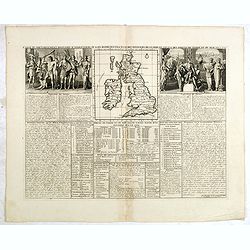
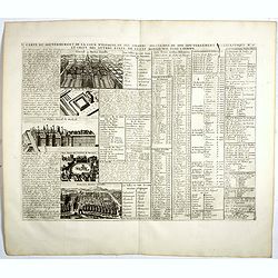
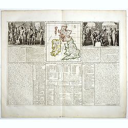
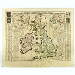
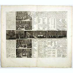
Carte du gouvernement militaire d'Angleterre où l'on représente l'état des officiers de guerre et celui des forces de terre et de mer.
Interesting sheet with a decorative map on the British Isles, with idyllic scenes showing councils of the various military officers of the British Isles, with descriptive...
Date: Amsterdam, 1720
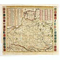
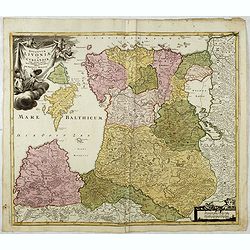
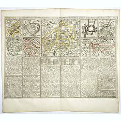
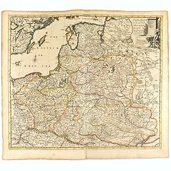
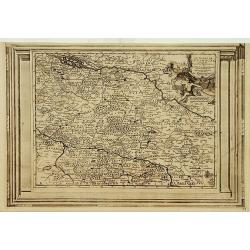
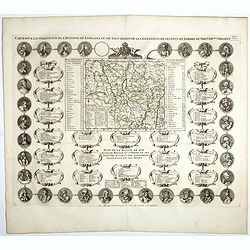
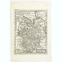
Carte De Pologne Avec La Chronologie Des Rois Et Des Ducs De Lithuanie, Ainsi Que Des Grands M. De L'Ordre Teutonique Les Evechez et Archeveches, et Les Armes Des Provinces . . .
Map of Poland with a key table to the towns, and 30 coats of arms on both sides, extending south the Black Sea. From Chatelain's monumental 7-volume "Atlas Historiqu...
- $1000 / ≈ €850
Date: Amsterdam, 1720
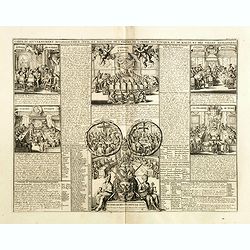
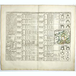
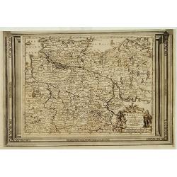
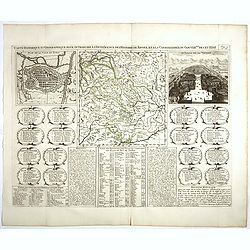
Carte du gouvernement ecclesiastique civil et militaire de l'Empire de l'ordre teutonique et de Malte et des villes anseatiques.
Interesting sheet with a detailed series of views showing the various councils of the Hanseatic League, including the councils of war, finance, state and the college of t...
- $75 / ≈ €64
Date: Amsterdam, 1720

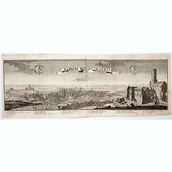
Riga metropolis Livoniae.
A spectacular panoramic view of Riga, with legends numbered from a-z and 1-16 in German. With the title in a banderol.After a design by Friedrich Bernhard Werner (1690-1...
Date: Augsburg, ca. 1720

Norimberga.
A spectacular panoramic town-view of Nuremberg, with legends numbered from 1-39 in German. With the title in a banderol.After a design by Friedrich Bernhard Werner (1690...
Date: Augsburg, ca. 1720
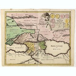
Asia intra Maeotim Pontum et Mare Caspium. . .
Striking map the Black Sea and Caspian Sea regions, featuring the geographical features known to the ancients and decorated with a vignette and 10 medallions.From "D...
- $195 / ≈ €166
Date: Nuremberg, 1720
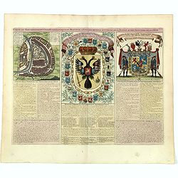
Carte du gouvernement civil ecclésiastique de moscovie, l'état des revenus et l'ordre de la justice et des officiers de la cour.
Interesting sheet with a detailed plan of Moscow, plus two large coats-of-arms, with descriptive French text, from Chatelain's monumental 7 volume Atlas Historique. In up...
- $950 / ≈ €807
Date: Amsterdam, 1720
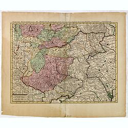
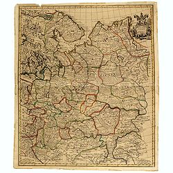
Partie Meridionale de Moscovie. . .
Centered on Moscow including Azow and part of present-day Ukraine in the bottom part of the map. The map is based on Delisle's important map of the region with revisions ...
- $200 / ≈ €170
Date: Amsterdam, 1720
Ducatuum Livoniae et Curlandiae cum vicinis Insulis Nova Exhibitio Geographica. . .
Detailed map of the northern Baltic coast by Homann, pre-dating the privilege.
Date: Nüremberg, 1720
Russiae vulgo Moscovia dictae, Partes Septentrionalis. . .
In the north the Murmansk Sea. Including the western coast of Nova Zembla. Title cartouche and two cartouches, the bottom right one showing two hunters, bears, stags etc....
Date: Amsterdam, 1720
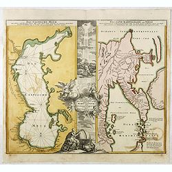
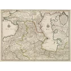
Das Caspische Meer / Das Land Kamtzadalie ...
Two maps on one sheet with the Caspian Sea on one side and northeastern Russia and Kamchatka on the other. The map of the Caspian Sea reflects the survey work of Russia�...
- $450 / ≈ €382
Date: Nuremberg, 1720
Carte generale des Etats du Czar. Empereur de Moscovie, ou L'on voit ce que ce prince possede en Europe ..
Impressive map of Russia Tartary and part of China with key tables to the towns. Depicting the different states belonging to the Czar in Asia and Europe, showing the path...
- $900 / ≈ €765
Date: Amsterdam, ca. 1720
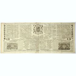
Carte du Gouvernement de la Cour d'Espagne. . .
Engraved text sheet, providing a detailed description of the infrastructure of Spain's ecclesiastical and military government as well as information listed in a lengthy t...
- $75 / ≈ €64
Date: Amsterdam, ca. 1720
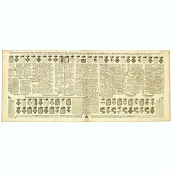
Carte du Gouvernement Ecclesiastique de France Divise en ses Archeveschez, Eveschez, Archidiaconnez, Archipretrez, Doyennez, et Parroisses.
This impressive plate provides a comprehensive list of the ecclesiastical divisions in the country with their corresponding coats of arms. A small inset map depicts the l...
- $55 / ≈ €47
Date: Amsterdam, 1720
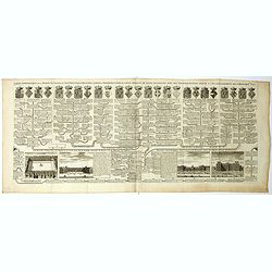
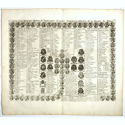
Carte genealogique de la famille Royale de Brunswick . .
A very detailed composite sheet with a genealogical table of the German royal families of Brunswick, Luneburg and Hanover, with descriptive French textZacharie Chatelain ...
- $50 / ≈ €42
Date: Amsterdam, ca. 1720
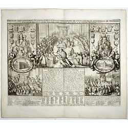
Carte du gouvernement ecclesiastique d'Angleterre . . .
Elegant engraving of the ecclesiastical government of England, with an engraving showing three images: in the centre, an ecclesiastical assembly (Convocation of the Clerg...
- $100 / ≈ €85
Date: Amsterdam, 1720
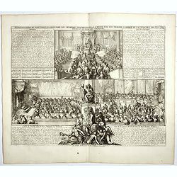
Représentation du parlement d'Angleterre, les chambres assemblées . . .
Engraving showing the British Parliament and an assembly before the King of England. From Chatelain's Atlas Historique, 1732-1739. In upper right margin: 'Tom. 7. No 26.H...
- $80 / ≈ €68
Date: Amsterdam, 1720
Carte des Grisons et des Communautez qui Composent leurs Ligues, les Etats de St. Gal, Neuchastel, Geneve et Quelques Autres Etats Alliez des Suisse.
This finely engraved sheet provides the history of various cities and regions allied with Switzerland at the beginning of the eighteenth century. The top section of the s...
- $150 / ≈ €127
Date: Amsterdam, 1720
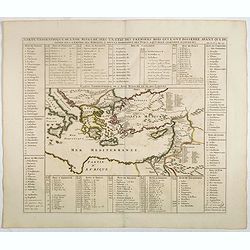
Carte geographique de l'Asie mineure avec un etat des premiers rois. . .
Map of the Mediterranean. This impressive engraving is a wonderful example of Chatelain’s elegant plates from his "Atlas Historique, Ou Nouvelle Introduction A L�...
- $120 / ≈ €102
Date: Amsterdam, ca. 1720
Carte genealogique de la maison des Valois. . .
This impressive engraving is a wonderful example of Chatelain’s elegant plates from his "Atlas Historique, Ou Nouvelle Introduction A L’Histoire …", Tom 7...
- $50 / ≈ €42
Date: Amsterdam, ca. 1720
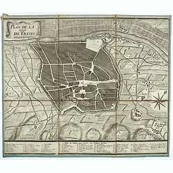
Plan de la ville de Treves.
Very rare town-plan of Trier by Didier Bugnon (1676-1736), geographer of the Duke of Lorraine. With numbered key (1-57) of the main buildings and buildings of the city. T...
Date: Paris?, 1720
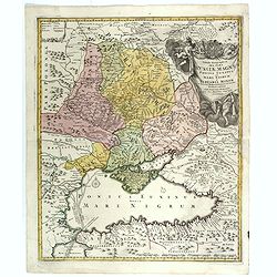
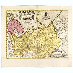
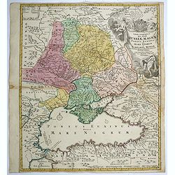
Tabula Geographica qua pars Russiae Magnae. . .
Homann's map is based upon Beauplan's general map of Ukraine but depicts the political changes of the preceding years. With decorative cartouches. Giving good detail alon...
Date: Nuremberg, 1720
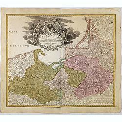
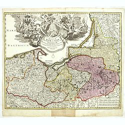
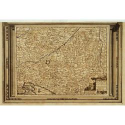
Regnum Borussiae gloriosis auspicijs Seerenissimi et Potentissimi Princip Friderici III Primi . . .
Map covering the region along the Baltic Sea from Prussia, Memel, to northern Poland, extending south to Poland, centered on Danzig, Konigsberg, Heilsperg, etc. Beautiful...
Date: Nuremberg, 1720
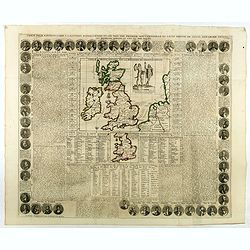
Carte Pour l'Introduction a l'Histoire d'Angleterre, ou l'on Voit son Premier Gouvernement, et l'Etat Abrege de cette Monarchie sous les Empereurs Romains, et sous les Rois Saxons.
The sheet includes a large inset map of Roman Britain including the English Channel and the western coast of France (200 x 255mm.). It also provides a wealth of informati...
- $200 / ≈ €170
Date: Amsterdam, 1720
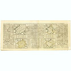
Nouvelle Carte des Differents Etats de la Monarchie Françoise Sous Iule Cesar, Sous les Rois de la Premiere, de la Seconde . . .
Four maps of France surrounded by historical and genealogical information to the history, chronology, ancient and modern genealogy of the french monarchy.Henri Abraham Ch...
- $75 / ≈ €64
Date: Amsterdam, 1720
Carte genealogique des comtes de Dreux, des Seigneursde Beaussart . . .
Genealogical chart of the earls of Dreux, from Chatelain's monumental 7 volume "Atlas Historique". Henri Abraham Chatelain (1684 – 1743) was a Huguenot pastor...
- $50 / ≈ €42
Date: Amsterdam, 1720
Carte du gouvernement d'Angleterre où l'on représente l'Etat des officiers de Guerre. . .
Decorative map on the British Isles, with idyllic scenes showing councils of the various military officers of the British Isles. Henri Abraham Chatelain (1684 – 1743) w...
- $50 / ≈ €42
Date: Amsterdam, 1720
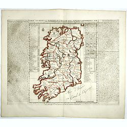
Carte ancienne et moderne de l'Irlande, avec quelques remarques sur son gouvernement . . .
Map of Ireland, based upon the ancient and modern cartographic information as of the beginning of the 18th Century. From Chatelain's monumental 7 volume "Atlas Histo...
- $200 / ≈ €170
Date: Amsterdam, 1720

Vue et description des principales villes de l'Armenie et de la Georgie avec les habillements des femmes du pays, et ceux des prêtres et religieux armeniens. . .Tom: V N° 11 Pag: 28
View and description of the principal Armenian and Georgian cities with illustrations of Armenian women's garments as well as priests' and monks' clothing. The views are ...
Date: Amsterdam, ca 1720
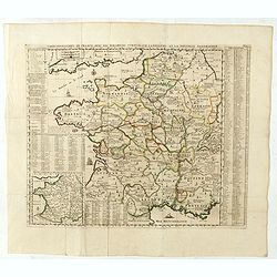
Carte Geographique du Royaume de France, avec des remarques curieuses sur l'ancienne, et la nouvelle geographie.
Map of France with a key table to the towns on both sides.Zacharie Chatelain (d.1723) was the father of Henri Abraham (1684-1743) and Zacharie Junior (1690-1754).They wor...
Date: Amsterdam, ca. 1720
Regnum Borussiae gloriosis auspiciis serenissimi et potentissimi princip. Friderici III primi Borussiae regis march. et elect. Brandenburg inauguratum die 18 Jan...1701.
Map covering the region along the Baltic Sea from Prussia to northern Poland, with the city of Kaliningrad (Königsberg), Danzig, and Heilsperg, etc. With a large title-c...
- $700 / ≈ €595
Date: Nuremberg, 1720

Beschrijving Gezicht van den Ykant af bezyden den Schreiers hoex Toren langs de Keulsche en Geldersche Kaei naer de Nieuwe Markt
This large engraving (560x920mm.) comes from a are series of 25 beautiful large views of Amsterdam and gives a colorful picture of the life and business of the city at th...
Date: Amsterdam, ca. 1720
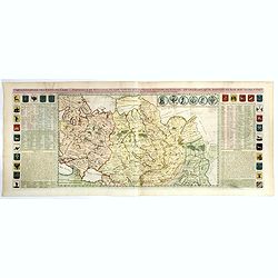
Tabula geographica qua pars Russiae Magnae..
A detailed map of western Russia, depicting the Ukraine, the Black sea, Turkey to the south, Romania and Bulgaria to the south west, Georgia to the east. Shows the cities...
Date: Nuremberg, 1720
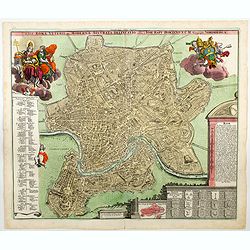
Urbis Romae Veteris ac Modernae Accurata Delineatio. . .
A wonderful 'bird's eye' view of the 'Eternal City' of Rome by Homann, although published in the first quarter of the eighteen century, the map portrays the city at the e...
Date: Nuremberg, ca 1720

Carte historique de la France, et l'Angleterre depuis la naissance de Jésus-Christ jusqu'à l'an 1700, qui contient en abrégé les événements ...
A rare wall map showing a chronological tree of French and English historical events from the year of the birth of Christ until 1700. The map is prepared by Jérôme Andr...
Date: Paris, c. 1721
Moscovey in Europe from the latest Observations . . .
Fine, highly detailed map of the regions of European Russia by John Senex. Each region is depicted in original outline color, and a small decorative cartouche is in the t...
- $450 / ≈ €382
Date: London, 1721
Poland and other the Countries belonging to the Crowne According to the Newest Observation 1719
Fine map of the Polish Empire in a second edition of the map, which had been published by Morden & Browne in 1710. The remnants of the earlier address, are still slig...
- $1200 / ≈ €1020
Date: London, 1721
Nouvelle carte d'Angleterre, d'Ecosse et d'Irlande, avec des instructions ..
Striking large folding map of the British Isles, with large insets of the Eastern and Western Hemispheres and the coats of arms for England, Ireland, Scotland and Wales. ...
- $200 / ≈ €170
Date: Amsterdam, 1721
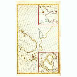
![[Set of 2 maps of Caspian Sea.] Carte marine de la Mer Caspiene. Levee suivant les ordres de S.M. Czariene, P](/uploads/cache/20009-250x250.jpg)
[Set of 2 maps of Caspian Sea.] Carte marine de la Mer Caspiene. Levee suivant les ordres de S.M. Czariene, P
Guillaume de l' Isle (1675-1724), Royal Geographer, was the most influential cartographer of the first quarter of the 18th century. ' Atlas de Géographie' (1700-12), pos...
- $350 / ≈ €297
Date: 1721
Carte des Pays Voisins de la Mer Caspiene dressee pour l' usage du Roy. . .
The map shows the area east of the Caspian Sea, including parts of Kazakhstan, Turkmenistan, Uzbekistan, and northern Iran. The area eastward from the Caspian is marked '...
- $750 / ≈ €637
Date: Paris, 1723

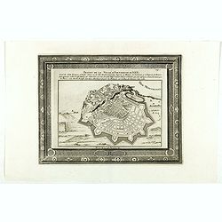
Plan de la ville de Malthe ses Forts, ses Nouvelles Fortiffications. . .
Detailed plan of Valletta. In upper right corner a key (A-Z & 1-32) to the principal places in town. Prepared by N.de Fer and re-issued by Danet.
Date: Paris, 1723
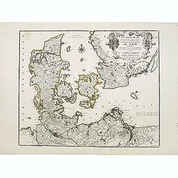
Le Royaume de Danemarc et les Etats.
Map centered on Sweden and North Germany.
Date: Paris, 1724
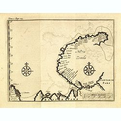
(Map of Nova Zembla with inset of Baye de Loms.)
Map of Nova Zembla with inset of Baye de Loms (5x7mm.).From the French reissue of the account of early Dutch voyages first published in 1608 by Commelin. The French trans...
- $100 / ≈ €85
Date: Amsterdam, F. Bernard, 1725
Ducatus Silesiae Iauranus. Aut : Frid : Kühnovio. . .
Rare Pieter Schenk edition of Friedrich Kubn's (Kühnovio) map of Jawor in southwest Poland based on Johann Gottfried Bartsch, map first published in Świdnica (then Schw...
Date: Amsterdam, 1700-1725
Polonia secondo le obzervazioni dell'accademiadi Parigi.
Uncommon Italian map of present day Poland and Lithuania prepared by Claude Buffier was a Jesuit theologian and geographer working in Paris, who wrote the Geographie Univ...
- $150 / ≈ €127
Date: Naples, Rome, ca. 1725
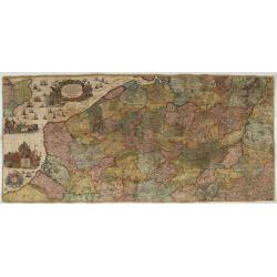
Les Provinces des Pais Bas Autrichiens contenants en XXIV Feuilles les comtées d'Artois, de Flandres, de Hainaut, de Namur et des Duchées de Luxembourg…
Rare wall map of the Catholic of Austrian Low Countries, roughly the southern part of present-day The Netherlands, Belgium and Luxembourg. Map has some large cartouches, ...
Date: Augsburg, 1725
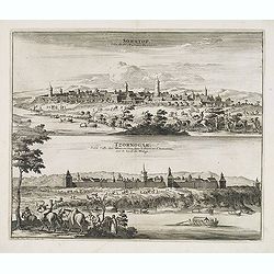
Soratof, ville de Tartarie Moscovite. / Tzornogar, Petite Ville des Moscovites, dans le Royaume d'Astracan, sur le bord du Volga.
Decorative engraving of two panoramic views in top Saratov with in the foreground the Volga River and in bottom a view of Chernyy Yar on the Volga River. This well execut...
Date: Leiden, 1719-1727
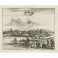
Cassimogorod ville de la Tartarie Moscovite.
Decorative view of the town of Kasimov on the Oka River, east from Moscow and south from Murom near the northern shore of the Caspian Sea. The city is seen from across th...
Date: Leiden, 1719-1727
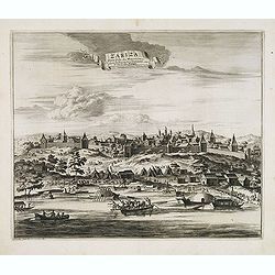
Zariza, petite ville des Moscovites, dans le royaume d'astracan, sur le bord du Wolga.
Decorative view of the town of Volgograd (Zarizyn) on the Volga River. This well executed engraving was published in 1729 and 1727 by Pieter van der AA, in Leiden in &quo...
Date: Leiden, 1719-1727
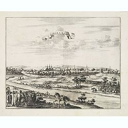
Moruma ville de la Tartarie Moscovite.
Decorative view of the town of Moruma, Russian city near the northern shore of the Caspian sea as seen from across the river Oka. This well executed engraving was publish...
Date: Leiden, 1719-1727
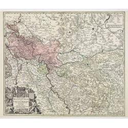
Le Duché de Lunebourg, suivant les nouvelles observations?
Uncommon edition of this map of a province of Germany. With decorative title cartouche upper right corner.This example is unusual in having the additional separately engr...
- $80 / ≈ €68
Date: Amsterdam, 1728
Cercle de la Basse Saxe, suivant les nouvelles observations..
Uncommon edition of this map of a province of Germany, including Hamburg, Bremen, etc. With decorative title cartouche lower right corner.This example is unusual in havin...
- $90 / ≈ €76
Date: Amsterdam 1728
La Souabe meridionale, suivant les nouvelles observations..
Uncommon edition of this map of Southern Germany. With decorative title cartouche lower right corner.This example is unusual in having the additional separately engraved ...
- $90 / ≈ €76
Date: Amsterdam 1728
L'Archeveché de Mayence, suivant les nouvelles observations..
With decorative title cartouche lower left corner. Including river Rhine. This example is unusual in having the additional separately engraved decorative framework border...
- $100 / ≈ €85
Date: Amsterdam, 1728
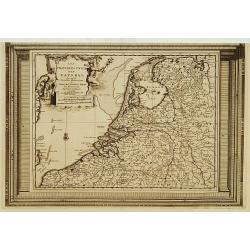
Les Provinces Unies des Pays Bas, suivant les nouvelles observations. . .
With decorative title cartouche upper left corner.This example is unusual in having the additional separately engraved decorative framework border around the map, the res...
Date: Amsterdam, 1728
Landgraviat de Hesse, suivant les nouvelles observations..
With decorative title cartouche lower right corner.This example is unusual in having the additional separately engraved decorative framework border around the map, the re...
- $90 / ≈ €76
Date: Amsterdam 1728

Carte du Gouvernement de Provence, suivant les nouvelles observations...
Fine copper engraved and decorative map of the Provence region in the south of France. It includes the cities of Nimes, Viviers, Avignon, Aix and Nice. The pictorial cart...
Date: Amsterdam 1728
Nova et Accurata Ducatus Cliviae et Comitatus Marchiae.
With an elaborate -uncolored- title cartouche.
Date: Augsburg, 1728
A Chart of the Sound -- A Map of the rivers Elbe and Weser -- The River Dvina and the harbour of Archangel.
Scarce sea chart by John Harris (1667?-1719) and James Knapton (d. 1738). Chart 20 from "Atlas maritimus & commercialis", shows Lapland and part of the Russ...
- $400 / ≈ €340
Date: London, J. Knapton, 1728
L'Italie dans son Premier Etablissement sous la Republique Romaine. . .
Map of Italy when first established under the Roman Republic after the division by Ayuguste Caesar, its various Papal governments: ancient Rome and its surround dings, a ...
Date: Amsterdam, 1728
Carte Historique et Geographique pour Introduire a l' Intelligence de l'Histoire de Savoye . . .
Folio sheet with an attractive map of the border region of France, Switzerland and Italy. An inset map of the fortification of Torino and the Palace of Venerie. Cartouche...
Date: Amsterdam, 1728
Carte genealogique des Rois de France avec l'Etat des Principaux Officiers de la Maison du Roy.
A genealogical tree of the French Kings with descriptive French text, from Chatelain's monumental 7 volume "Atlas Historique". Henri Abraham Chatelain (1684 –...
- $35 / ≈ €30
Date: Amsterdam, 1728
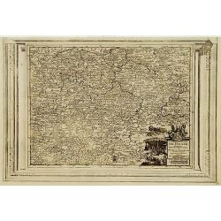
Carte du Gouvernement Civil de France.
This impressive engraving is a wonderful example of Chatelain’s elegant plates. It provides a detailed description of the infrastructure of the French government. Ornam...
- $75 / ≈ €64
Date: Amsterdam, 1728
Carte Pour L'Intelligence De L'Histoire De Lorraine . . .
Map of Lorraine, surrounded by 34 portraits of the rulers of Lorraine and information concerning the present government structure of the Duchy. Surmounted by an elaborate...
Date: Amsterdam, 1728
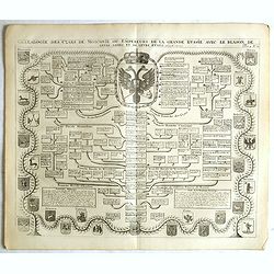
Généalogie des Cazrs de Moscovie ou empereurs de la grande Russie . . .
Genealogical tree, showing the lineage of the Russian Czar's, dating back to 840 according to Hubner. Published by Henri Abraham Chatelain (1684 – 1743) a Huguenot past...
- $250 / ≈ €212
Date: Amsterdam, 1728
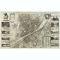
Florentia Pulcherrima et Ruriae Civitas.
Detailed bird's-eye view of the town of Florence in Tuscany region, first published in Frederick de Wit's rare town book. With two keys 1-17 and 1-228 to important spots ...
Date: Amsterdam, Leiden, 1697 / 1729
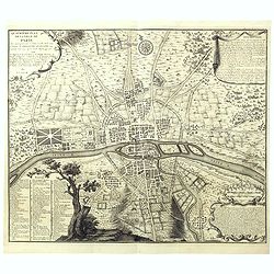
![Lutece conquise par les François sur les Romains ou second plan de la ville de Paris [...] par M.L.C.D.L.M.](/uploads/cache/42141-250x250.jpg)
Lutece conquise par les François sur les Romains ou second plan de la ville de Paris [...] par M.L.C.D.L.M.
Engraved plan of Paris, published in "Traité de la police de Nicolas de Lamare". Oriented to the North with a compass rose and equipped with a double scale (40...
Date: Paris, 1729
Quatrième plan de la ville de Paris . . .
Engraved plan of Paris, oriented to the North with a compass rose (upper part) and equipped with a double scale (400 geometrical steps and 1000 not common) with a brief c...
Date: Paris, 1729
Russia or Moscovy with its Acquisitions &c.
Herman Moll's map of western Russia, or Muscovy, published in London during the first half of the eighteenth century. It shows the newly acquires lands taken from Sweden ...
- $200 / ≈ €170
Date: London, 1729
Projet de la forteresse de Nice.
Nice city plan of Nice at the Mediterranean sea. From the " Les forces de l'Europe, ou description des principales villes, avec leurs fortifications".
Date: Leiden, 1729
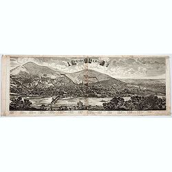
Heidelberg.
A spectacular panoramic view of Heidelberg, with legends numbered from 1-72 in German. With the title in a banderol.After a design by Friedrich Bernhard Werner (1690-1776...
- $1500 / ≈ €1275
Date: Augsburg, 1729
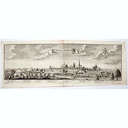
Neis in Schlesien. (Nysa)
A spectacular panoramic view of Nysa in southwestern Poland, with legends numbered from 1-23 in German. With the title in a banderol.After a design by Friedrich Bernhard ...
- $2500 / ≈ €2125
Date: Augsburg, 1729
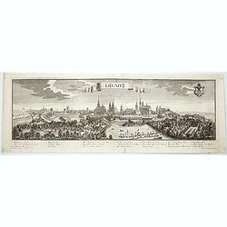
Lirgnitz. (Legnica)
A spectacular panoramic view of Legnica in southwestern Poland, in the central part of Lower Silesia, with legends numbered from 1-20 in German. With the title in a bande...
- $2500 / ≈ €2125
Date: Augsburg, 1729
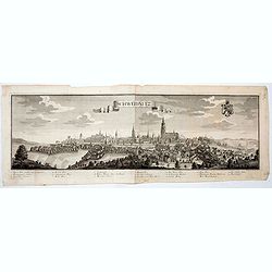
Schweidnitz. (Swidnica)
A spectacular panoramic view of Swidnica is a city in south-western Poland, with legends numbered from 1-19 in German. With the title in a banderol.After a design by Frie...
- $2500 / ≈ €2125
Date: Augsburg, 1729
Bamberg in Francken.
A spectacular panoramic view of Bamberg, with legends numbered from 1-24 in German. With the title in a banderol.After a design by Friedrich Bernhard Werner (1690-1776) w...
- $1500 / ≈ €1275
Date: Augsburg, 1729
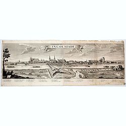
Ingolstadt.
A spectacular panoramic view of Ingolstadt in Bavaria, with legends numbered from A-P and 1-6 in German. With the title in a banderol.After a design by Friedrich Bernhard...
- $1500 / ≈ €1275
Date: Augsburg, 1729
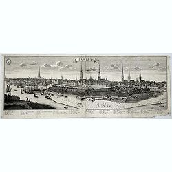
Hamburg.
A spectacular panoramic view of Hamburg, with legends numbered 1-19 and A-Z in German. With the title in a banderol.After a design by Friedrich Bernhard Werner (1690-1776...
- $2000 / ≈ €1700
Date: Augsburg, 1729