Browse Listings
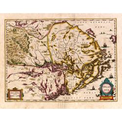
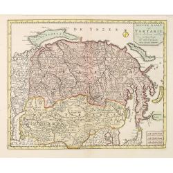
Uplandia.
Covers the area of the modern Uppsala, the vicinity of Stockholm, and includes most of Aland.
Place & Date: Amsterdam, 1639

Histoire Naturelle, Civile, Et Ecclésiastique..'
First French edition, published by P. Gosse, J. Neaulme and B. Lakeman. The basic work on Japan from the second half of the 17th century when it was still forbidden for f...
Place & Date: Amsterdam, 1729

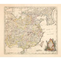
Huquang, Kiangsi, Chekiang ac Fokien.
A reissue of Janssonius' map of south east China, with wash color and uncolored cartouches.The map is based on the maps of Martin Martini, themselves based on Chinese sou...
Place & Date: Amsterdam, 1720

Noordoost Cust van Asia van Japan tot Nova Zembla.
Important for its early depiction of Hokkaido and the Islands to the North of Japan. Ships navigate the seas around the Siberian, Chinese and Japanese coast extending as ...
- $3000 / ≈ €2807
Place & Date: Amsterdam, 1666

Currus Veliferi Illmi. Pr. Mauritii Nassouvii. (Prince Maurits' sailing-carriage, designed by Simon Stevin. )
Prince Maurits' sailing carriages had been designed by Simon Stevin. The Prince, always accessible to new inventions of his old instructor, could not please the foreign a...
Place & Date: Amsterdam, 1649
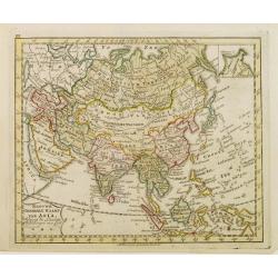
Nieuwe Generale Kaart van Asia.
Uncommon map of Asia, engraved by A.Krevelt. In upper right hand corner inset map of Siberia.
- $120 / ≈ €112
Place & Date: Amsterdam, 1792

Shinkan Nagasaki no Dzu.
The oldest of these so-called Nagasaki pictures (Nagasaki-zu) were two panoramic prints by the artist Chikujuken that served as guides to the city of Nagasaki for visitor...
Place & Date: Nagasaki, 1801
Vue de Nangasaki.
Steel engraved of Nagasaki from the water, identifying clearly Deshima, the V.O.C. trading post and the Dutch flag. Japanese and Chinese sloops in the fore ground. Engra...
- $125 / ≈ €117
Place & Date: Paris, 1842

'T Eilandje Desima verblyf plaats der Hollanders in Japan.
Bird's-eye view of Dejima copied from a manuscript by Voogt, who was second-in-command on Deshima in 1713. The island is viewed from the landside, depicting the developme...
Place & Date: Amsterdam, 1739

Fossa Sanctae Mariae.
Detailed map of part of the country between rivers Rhine and Meuse showing a canal to be dug between 1626 and 1628 between Rheinberg in Germany and Venlo. A deficiency of...
Place & Date: Amsterdam, 1645
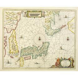
Nova et accurata Japoniae terrae Esonis, ac Insularum adjacentium.
The map is of interest in showing Korea as a curiously shaped island and in revising the shape of the three main Islands of Japan. A re-issue of Janssonius' map with the ...
- $2000 / ≈ €1871
Place & Date: Amsterdam, 1700

Tabula Bergarum ad Zomam Stenbergae et novorum ibi operum.
The map gives an outline of the Scheldt from Bergen op Zoom to Antwerp, with all the ramparts built between 1622 and 1627.
Place & Date: Amsterdam, 1647
-250x250.jpg)
Hern Johann Baptisten Taveniers..Vierzig Jaehrige Reize..
This German edition includes Tavernier's map of Japan in a reduced form (210x315mm) and contains legends about the country's nature, e.g., where gold is mined and plottin...
Place & Date: Nuremberg, 1681

Germaniae Nova ac Accurata Descriptio.
This "carte à figures"- map covers the Low Countries, Germany, Poland, Switzerland and Austria. Overall a very good copy of this excellently engraved, uncommon...
Place & Date: Amsterdam, 1642
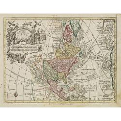
Nov' Orbis Sive America Septentrionalis. . .
Miniature map of North America, a reduction of the appropriate part of Seutter's folio map of the Americas, drawn by Albert Seutter. An unusual looking map, its projectio...
- $250 / ≈ €234
Place & Date: Augsburg, J.M.Will, 1778

De Texel Stroom .. vant Marsdiep./ Caarte van De Mase...
Two decorative charts on one sheet, one depicting Texel and the entrance of the Zuider Zee with an inset showing the north coast of West-Friesland, the other depicting th...
- $750 / ≈ €702
Place & Date: Amsterdam, 1660

Palatinatus Rheni Nova et Accurata Descriptio.
Early state (1630) of Visscher's "carte à figures"- map of the German Rhine River Valley. Inset views of Frankfurt am Main, Mainz, Speyer, Worms and Heidelberg...
Place & Date: Amsterdam, 1630

Coloniensis Archiepisscopatus.
Extremely rare first edition of this beautiful map of Cologne and Dusseldorff.Jodocus Hondius Jr. planned to produce a new modern atlas less dependent on the Mercator pla...
Place & Date: Amsterdam, 1629
![Parthie aus dem Binnensee [Japan]](/uploads/cache/01312-250x250.jpg)
Parthie aus dem Binnensee [Japan]
Anonymous drawing made by a German during his visit to Japan. The drawing shows a lake with two Japanese vessels and a building with a Japanese flag in an mountainous lan...
- $150 / ≈ €140
Place & Date: Japan, c. 1890
Monasteriensis Episcopatus.
The extremely rare first edition of this beautiful map of Munster.Jodocus Hondius Jr. planned to produce a new modern atlas less dependent on the Mercator plates that his...
Place & Date: Amsterdam, 1629
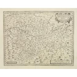
Westphalia Ducatus.
Extremely rare first edition of this beautiful map of Westphalia.Jodocus Hondius Jr. planned to produce a new modern atlas less dependent on the Mercator plates that his ...
Place & Date: Amsterdam, 1629
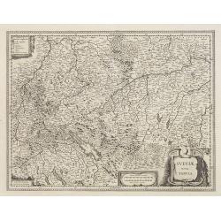
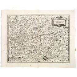
Sueviae Nova Tabula.
Extremely rare first edition of this beautiful map of Swaben, including Ulm, Augsburg, Stuttgart, Zurich, Lucerne and Lake Constance.Jodocus Hondius Jr. planned to produc...
Place & Date: Amsterdam, 1629

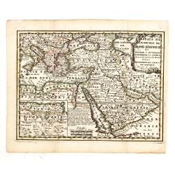
Carte de L'Egypte de la Nubie de L'Abissinie..
Prepared by G.de l'Isle. Uncommon issue by Hendrik de Leth. Very detailed map of northeastern Africa, the Red Sea and the Arabian peninsula shows the political divisions ...
- $500 / ≈ €468
Place & Date: Amsterdam 1740
Estats de L'Empire du Grand Seigneur dit Sultan et Ottomans Empereur des Turcs. . .
The map shows the extent of the Ottoman Empire from the Balkans to Persia, including all of Arabia and North Africa (an inset map at lower left shows the continuation of ...
- $150 / ≈ €140
Place & Date: Amsterdam, 1740
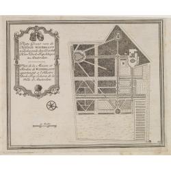
Gemete Kaerte van de Stede Beverwyk, zoo als die tegenwoordigh zich vertoont.
Uncommon plan of Beverwijk made in the year 1739. Published in Hollandsche Arcadia. Title in Dutch and French.
- $75 / ≈ €70
Place & Date: Amsterdam, ca.1740
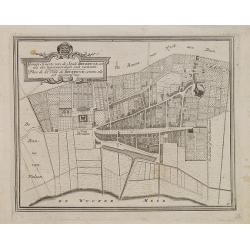
Platte Gront van de Hofstede Waterlant toebehorende den Ed. Achtb. Heer Dirk Trip Schepen te Amsterdam.
Uncommon plan of Hofstede Waterlant. Published in Hollandsche Arcadia. Title in Dutch and French "Plan de la Maison et Jardins appartenant a l'Illustre Dirk Trip Ech...
- $40 / ≈ €37
Place & Date: Amsterdam, 1740

Comitatus Flandria.
A highly decorative map with in the left and right top corners the pictures of archduke Albert of Austria and Isabella, queen of Spain. In the left and right borders cost...
Place & Date: Amsterdam, 1648
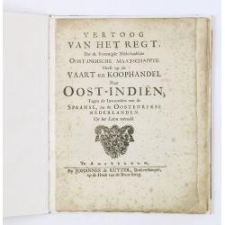
Vertoog van het regt, Dat de Vereenigde Nederlandsche Oost-Indische maatschappye Heeft op de Vaart en Koophandel naar Oost-Indiën, Tegen de inwooners van de Spaanse, nu de Oostenrykse Nederlanden.
Dutch translation of the Latin edition, published in 1723. Westerveen was the secretary of the Dutch East India Company and writes on the right of the VOC to trade as wel...
- $1200 / ≈ €1123
Place & Date: Amsterdam, 1724

De Tesselstroom met de Gaten van Marsdiep./ De Mase met. . .
Three charts on one sheet depicting the entrances to the Zuiderzee between Holland, Texel and Vlieland. The entrances of the Maas with Rotterdam and in a small inset the ...
- $500 / ≈ €468
Place & Date: Amsterdam, 1662

Nieuwe gemeten kaart van de colonie de Berbice : met der zelver plantagien en de namen der bezitters in het ligt gebragt door Reiner & Iosua Ottens kaartverkopers te Amsterdam 1740.
Rare separately published map of the colony of Berbice in present-day Guyana showing the Berbice River Valley and the plantations along the river. North on map of the col...
Place & Date: Amsterdam, 1740

Vue de Boston vers le Cale du Port.
A view of the port of Boston, the center of New England shipping in the colonial period. The closing of the port after the Boston Tea Party led to the calling of the Firs...
Place & Date: Augsburg 1762
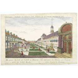
Die innere Aussicht des Castells in Batavia . . .
Showing the inside-square of the V.O.C. headquarters in Jakarta.The hand colored engraving is much perforated and the windows are cut out, a thin transparent paper is mou...
- $500 / ≈ €468
Place & Date: Augsburg, 1750

Ambassades mémorables de la Compagnie des Indes orientales des Provinces Unies vers les empereurs du Japon.
First edition in French of this important work on Japan, a work whose illustrations "represent a high-water mark in book illustrations of the 17th century" (Lac...
- $5500 / ≈ €5146
Place & Date: Amsterdam, 1680
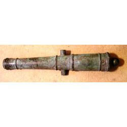
A fine bronze cannon.
Cannon built up of two truncated conusses, differing in size, the steps marked by mouldings shaped as flat bands preceded by ogees: base ring similar; breech with ogee-sh...
Place & Date: Amsterdam, ca. 1755
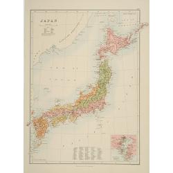
Japan.
A detailed lithographed map of Japan including Hokkaido and including a small inset of the environs of Tokyo & Yokohama. Lower part map a numbered key to divisions an...
- $200 / ≈ €187
Place & Date: Edinburg, 1884
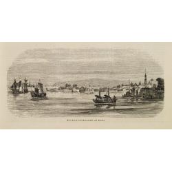
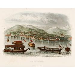
Der Hafen von Nangasaki auf Kiusiu.
A panoramic view of the harbour and city of Nagasaki with extensive shipping.
- $100 / ≈ €94
Place & Date: Germany, 1847
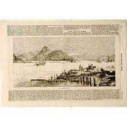
View of Nagasaki, Japan.
A panoramic view of Nagasaki harbour from the Illustrated Times of November 28th., 1863. With accompanying one column descriptive text on verso of Nagasaki.
- $100 / ≈ €94
Place & Date: London, 1863

Carte des parties Nord et est de l'Asie.. (5 maps on one sheet)
Five maps on one sheet, showing California, Alaska and Syberia, Korea and Japan. South to Korea the island "Quelpaerts".The map is from Diderot's "Encyclop...
- $200 / ≈ €187
Place & Date: Paris, 1772
Nieuwe kaart van Tartarie.
A map of Tartary, Korea and part of Japan. The map is most notable for the confusion between Kamchatka and Iesso.Engraved by J.Keyser in 1731.
- $250 / ≈ €234
Place & Date: Amsterdam, 1731 / 1750
China as surveyed by the Jesuit Misionaries between the years 1708 & 1717 with Korea & the adjoining parts of Tartary.
The map is of interest for the use of Eastern Sea or Sea of China, the sea south of Korea. In the sea along the coast line of Korea : "Kau-Li-Qua or King:m of Korea&...
Place & Date: London, c. 1760
Selling price: $500
Sold in 2014