Browse Listings
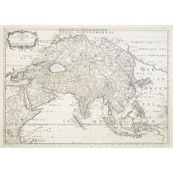
Asie.
Map of Asia still showing Corey as an island. Including Americas West coast.More about Western mapping of Korea maps. [+]
- $500 / ≈ €468
Place & Date: Paris, 1650
![Oceanie. [Manuscript on paper]](/uploads/cache/01830-250x250.jpg)
Oceanie. [Manuscript on paper]
Decorative manuscript map on paper covering South East Asia, Australia and New Zealand.
Place & Date: France ?, ca. 1850
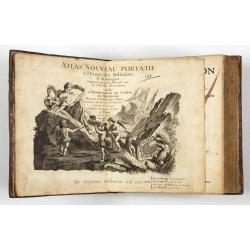
Introduction a la Geographie
Engraved title, with 91 double-page engraved maps mostly including European nations, but including World and continents, Turkey, the Holy Land, Persia, China, Japan, Egyp...
- $3000 / ≈ €2807
Place & Date: Paris, 1756

A chart of the northern part of the Indian Ocean..
Chart of the northern part of the Indian Ocean, including part of Arabia, India and Sri Lanka prepared by D'Apré de Mannevillette and published in London by Laurie and W...
- $750 / ≈ €702
Place & Date: London 1794

Poli Arctici, et circumiacentium terrarum descriptio novissima. . .
A re-issue of the Hondius' plate. A particularly decorative map of the North Pole with Iceland. Several Dutch names in Labrador. The toponymy in Canada reflects the conti...
Place & Date: Amsterdam, 1660

Account of a voyage of discovery to the west coast of Corea.
BRITAIN'S FIRST ACCURATE ACCOUNT OF KOREA & OKINAWANS. With an appendix containing charts and various hydrographical and scientific notices by captain Basil Hall and ...
Place & Date: London, 1818
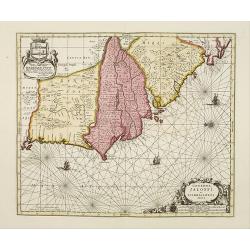
Genehoa Jaloffi et Sierraliones regna.
Decorative and detailed map of the West African Coast, from Senegal to Sierra Leone. In the center the river Gambia to the mouth in the Atlantic. Upper left a dedication ...
Place & Date: Amsterdam, 1670 / 1720
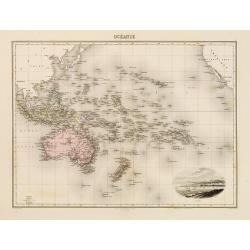
Océanie.
In lower right hand corner a view of Nouméa. Showing the Pacific including California. Engraved by L.Smith.
- $90 / ≈ €84
Place & Date: Paris, 1874

Manuscript map of the Bay of Nagasaki.
An extremely rare manuscript chart in brown ink and wash color on a printed sheet of paper with a system of rhumblines and latitude scales. This chart shows the Bay of Na...
Place & Date: Amsterdam, 1750
-250x250.jpg)
Lyste vande prysen der goederen ingekoft by de Kamer. . .
Rare price list of meat, bacon, wheat, rye, butter, cheese, olive oil, Spanish wines, Bordeaux, brandy etc.On front page in letter press Lyste Van de Pryfen der Goederen,...
Place & Date: Amsterdam, 1685
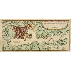
Plan du port et de la ville de Nangasaki.
This plan originates from Charlevoix's work Histoire et description Générele du Japon . His first in 1715 published work was the Histoire de l'etablissement du christia...
- $600 / ≈ €561
Place & Date: Paris, 1760

Manuscript plan of Havana harbour.
Manuscript chart with good nautical detail and soundings of Havana harbour.
Place & Date: Spain c.1820

Bernoise.
A decorative costume print from "Costume de div. Pays", No.17. Engraved by Getine after Lanté.
- $80 / ≈ €75
Place & Date: Paris, c. 1827
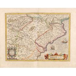
Arragonia et Catalonia.
Aragon and Catalonia. Decorative map with mountain relief and river. 2 finely engraved sailing boats.Mercator was born in Rupelmonde in Flanders and studied in Louvain un...
- $250 / ≈ €234
Place & Date: Amsterdam, 1628
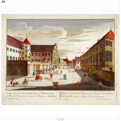
Der Zeug=Platz gegen S.Morizen Plaz zu Augspurg.
A well-known publisher of optical prints, established in Augsburg.In the eighteenth and nineteenth centuries there were many popular speciality establishments in Paris, A...
- $200 / ≈ €187
Place & Date: Augsburg, 1760
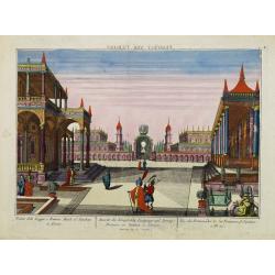
Vue des Promenades et les Fontaines d'Ispahan.
Carmine was a well-known publisher of optical prints, established in Augsburg.In the eighteenth and nineteenth centuries there were many popular specialty establishments ...
- $250 / ≈ €234
Place & Date: Augsburg 1770
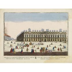
(Berlin) Prospectus Armamentarii regnii versus arcem principis regis haereditarii Berolini.
A square in Berlin. In the eighteenth and nineteenth centuries there were many popular speciality establishments in Paris, Augsburg and London which produced optical view...
- $200 / ≈ €187
Place & Date: Italy, 1770
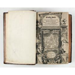
Cruydt-Boeck van Remberus Dodonaeus. . .
Scarce, the last edition of Dodoens' Cruydt-Boeck, one of the most influential and important botanical works of the 16th and 17th centuries. With richly engraved frontisp...
Place & Date: Leyden, 1612

A ship's hour glass
The element common to celestial position-finding, the calculation of speed for dead reckoning and even everyday life at sea is the time: hence ways of determining and kee...
Place & Date: ca. 1790
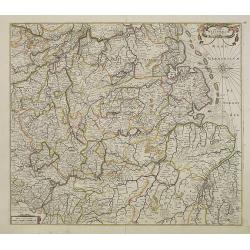
Nova Totius Westphaliae descriptio.
Map of the northern provinces of Germany, including the Wad islands. West to the top. Including Bremen, Hildesheim, Kassel, Düsseldorf, etc. Also including the Dutch pro...
Place & Date: Amsterdam, 1680

Hassia Landgraviatus.
Centered on the town of Kassel.
Place & Date: Amsterdam, 1650

Tabula comitatus Hollandiae. . .
Fine map of the provinces of North and South Holland. In upper left hand corner an inset with the islands of Texel and Vlieland.
Place & Date: Augsburg 1760
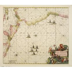
Nova Hispaniae, Chili, Peruviae, et Guatimalae Littorae..
A superbly decorative chart, oriented with north to the left of the sheet, covering the coasts of Central America, Peru, Chile, Jamaica and part of Cuba and Porto Rico. S...
- $1000 / ≈ €936
Place & Date: Amsterdam, 1660
Nederlandsche Factory DEZIMA 1828.
Bird's-eye view of the manmade island of Deshima, a trading post of the V.O.C. from 1641 onward.Underneath the map a legend in Dutch and German with names of all the buil...
Place & Date: Leiden, 1832-1852
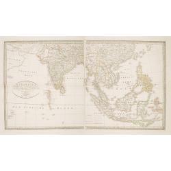
Charte von Ostindien Diesseits Und Jenseits Des Ganges / nach den neuesten astronomischen Beobachtungen auch andern sichern Hülfsmitteln neu entworfen. . .
Prepared by I.C.M.Reinecke giving good detail in India, Indonesia and the Philippines.
- $800 / ≈ €749
Place & Date: Weimar, 1822

Carte de la Manche. . .
Decorative chart showing the Chanel, with the coastline of France from La Baie de Douarnenez to Dunkerque, and the coastline of England from Stroble head to Manning Tree....
Place & Date: Amsterdam, 1692
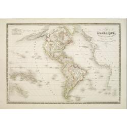
Carte d'Amerique dressée par Pierre Tardieu. . .
Detailed map prepared by Pierre Tardieu. With good detail on Alaska. Including New Zealand.
- $450 / ≈ €421
Place & Date: Paris, 1831
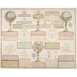
Analytique des différentes positions de la Sphère, des différens systemes, des révolutions et des distances des Planètes, &c
Containing "Globe Celeste", "Sphere de Copernic", "Globe Terrestre", "Systeme de Ptolomee" ; including diagrams of the solar syste...
Place & Date: Paris, 1780

Carte de la Baye et du Port de Trinquemalay dans L'Isle de Ceylan.
Chart showing the bay of Trincomalee, Ceylon (Sri Lanka). Trincomalee is natural deep water port on the east coast of Sri Lanka, about 110 miles northeast of Kandy. It is...
- $250 / ≈ €234
Place & Date: Paris, 1775
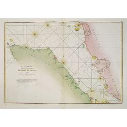
Carte Plate de la partie Septentrionale du Detroit de Malac, depuis de la rade d'Achem jusqu'a Malac.
French chart of the Island of Sumatra and the Malay Peninsula separated by the strait of Malacca in Indonesia.Latitude and longitude scales, compass rose and system of rh...
- $500 / ≈ €468
Place & Date: Paris, ca. 1775

Belgium Foederatum emendate auctum et novissimé editum.
Fine detailed map of the area of the modern Netherlands less the southern part of Limburg. Title cartouche representing the commerce, the arts and the sciences. The Lion ...
Place & Date: Amsterdam, 1680
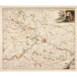
Comitatus Namurci Tabula in Lucem. . .
Centered on Namen, with decorative title cartouche upper right.
Place & Date: Amsterdam, 1680
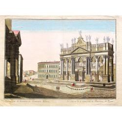
Tempum S.Joannis in Laterano Romae. . .
A so-called optical print. In the eighteenth and nineteenth centuries there were many popular specialty establishments in Paris, Augsburg and London which produced optica...
- $150 / ≈ €140
Place & Date: Italy, ca.1780
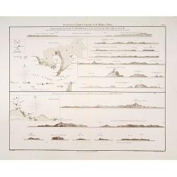
Küstenansichten von Japan bis Capstadt und St. Helena in 5 Blättern.
Prepared by Officer S.M.S. Arcona during the German expedition of 1860-1861 to South East Asia. Lithographed by Lippold and printed by C.Ulrich of Berlin. Sheet 2 from a ...
Place & Date: Berlin, 1863
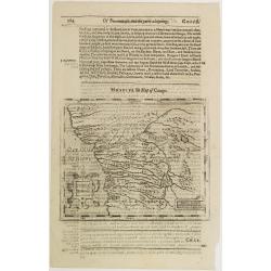
Congi regnu.
Samuel Purchas' edition of the Mercator/Hondius Atlas Minor . Early map of Congo published in his famous collection of voyages His Pilgrimes . With descriptive text in En...
- $100 / ≈ €94
Place & Date: London, 1645
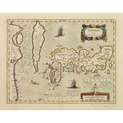
Japoniae Nova Descriptio.
The map is identical in cartographic detail to the Hondius map of 1606 but newly designed ornate cartouches have been added. The three main islands of Japan are shown wit...
- $1800 / ≈ €1684
Place & Date: Amsterdam 1650
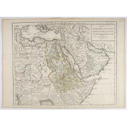
Carte de L'Egypte de la Nubiede L'Abissinie. . .
Including the Arabian Peninsula. Giving good detail on Egypt. Engraved by Desrosiers.More about Mapping of Arabia [+]
- $300 / ≈ €281
Place & Date: Paris, 1707
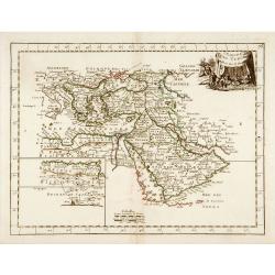
L'Empire des Turcs.
With decorative title cartouche upper right. Good detail in the Arabian peninsula.More about Mapping of Arabia [+]
- $240 / ≈ €225
Place & Date: Paris, 1767
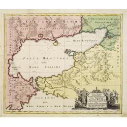
Maris Assoviensis vel de Zabache et Paludis Maeotidis. . .
A very detailed map showing the Black Sea, Azow and Rostow area.
Place & Date: Augsburg, 1720
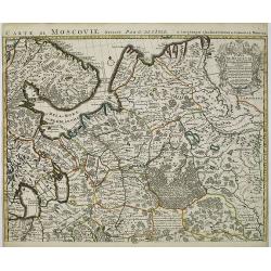
Carte de Moscovie. . .
Centred on Moscow, including Lapland. With fine uncolored title cartouche.
Place & Date: Amsterdam, 1720