Browse Listings in Australia & Oceania

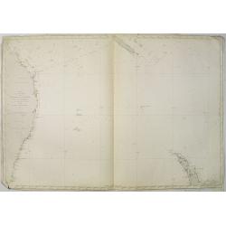
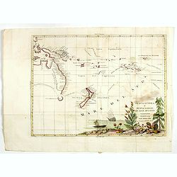
.Pascaerte Vande Zuyd-Zee tusschen California, en Ilhas de Ladrones. . .
A decorative and most interesting map - being one of the earliest of the Pacific to record the observations of Tasman's voyages. The northern part of the island of Califo...
Place & Date: Amsterdam, 1666
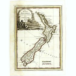
La nuova Zelanda delineate sulle ultima osservazioni del Capitan Cook.
First edition on laid paper Cassini’s splendid early map of New Zealand, being the most decorative version of Captain Cook's map of New Zealand, published in the very s...
Place & Date: Rome, 1798
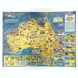
Australia, The Awakening Giant.
This large, fully colored map of Australia was published in America and Australia in the late 1960s. The map is covered in small colored illustrations, connected with loc...
Place & Date: Victoria, 1967
![Oceanie. [Manuscript on paper]](/uploads/cache/01830-250x250.jpg)
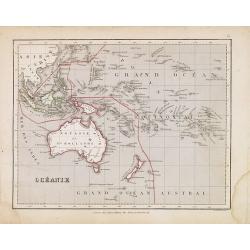
Oceanie. [Manuscript on paper]
Decorative manuscript map on paper covering South East Asia, Australia and New Zealand.
Place & Date: France ?, ca. 1850

Plan de L'Isle de Paque / Plan de la Baie de Cook.
Two engraved maps and four coastal profiles of Easter Island in the Pacific. First published in the Atlas du Voyage de la Perouse. This is the edition of the extremely ra...
Place & Date: Paris, 1797-1807
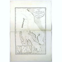
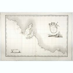
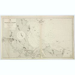
Carte de la Baie des Chiens-Marins (Shark's Bay de Dampier). . .
A strikingly detailed chart of a portion of the coastline of Western Australia, titled 'Carte de la Baie des Chiens-Marins, which was also explored by William Dampier. Th...
Place & Date: Paris, 1807
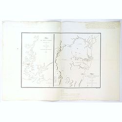
Plan du Port Jackson / Plan du Comte de Cumberland.
Two maps on one sheet showing the earliest scientific surveys of Port Jackson and the area surrounding Sydney Harbour, undertaken by the French in 1802. This is the editi...
Place & Date: Paris, 1807
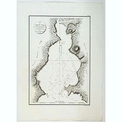
Plan du Port du Nord de la Baie de la Recherche.
A French maritime chart of the plan of the northern portion of Recherche Bay on the S.E. tip of Tasmania. The chart has some physical detail, outlining trees and hills, b...
Place & Date: Paris, ca 1807

Plan du Port du Sud de la Baie de la Recherche / Croquis de la Baie des Moules. . .
A French maritime charts of the Port du Sud in Research Bay and the mouth of the Bay of Mussels, both in southern Tasmania. This is the edition of the extremely rare atla...
Place & Date: Paris, ca 1807

Plan de la Baie de L'Adventure. . .
A French maritime chart of Adventure Bay in S.E. Tasmania. Adventure Bay is the name of both a township and a geographical feature on the eastern side of Bruny Island. Th...
Place & Date: Paris, ca 1807
![Le Isole di Sandwich delineate sulle osservazioni del Cap Cook. [Hawaii]](/uploads/cache/43195-250x250.jpg)
Le Isole di Sandwich delineate sulle osservazioni del Cap Cook. [Hawaii]
FIRST EDITION on laid paper. Cassini’s splendid map depicts Sandwich islands, old name for Hawaii islands, at the end of the eighteenth century. The splendid cartouche ...
Place & Date: Rome, 1798

La Nuova Olanda e La Nuova Guinea delineate sulle ultima osservazioni.
Cassini’s splendid and rare map of Australia and New Guinea, from the 'Nuovo Atlante Geografico Universale'. The emphasis of the map is the charting of Captain Cook dow...
Place & Date: Rome, 1798
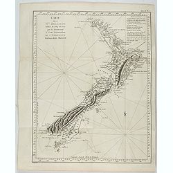
Carte de la Nouvelle-Zelande visitée en 1769 et 1770 par le Lieutenant J. Cook.
Original French Edition of James Cook's Chart of New Zealand, from the First French Edition of Hawkesworth's Voyages. Map of New Zealand, engraved by Bernard. The most im...
Place & Date: Paris, 1774
![Nouvelle-Hollande: Ile Decrès. - Détails du Casoar de la Nouvelle Hollande. [plate XLL]](/uploads/cache/46362-250x250.jpg)
Nouvelle-Hollande: Ile Decrès. - Détails du Casoar de la Nouvelle Hollande. [plate XLL]
Plate illustrating Casoar, by Lesueur, from Voyage de découvertes aux terres Australes by François Péron, 1824.The French expedition under Nicolas Baudin, was commissi...
- $75 / ≈ €70
Place & Date: Paris, 1824
Carte Generale de la Terre Napoleon (à la Nouvelle Hollande)... par M.L. Freycinet an 1808.
Fine map of part of Australia prepared by Louis Freycinet during his voyage under Captain Thomas Baudin in 1800-1803. The longitude is calculated from Paris.The cartouche...
- $4000 / ≈ €3743
Place & Date: Paris, Imprimerie Royale, 1811
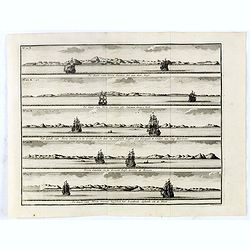
De Kust van Nova Guinea tot aan deze bogt . . .
Five views of the coast of New Ireland in New Guinea. Abel Tasman, but also Willem Schouten and Isaac le Maire, thought that this was the coast of New Guinea. In reality ...
- $150 / ≈ €140
Place & Date: Amsterdam, 1726
![Le Capitaine Wallis est attaqué dans le Dauphin par les Otahitiens. [Tome II Pl. 1ère.]](/uploads/cache/26099-250x250.jpg)
Le Capitaine Wallis est attaqué dans le Dauphin par les Otahitiens. [Tome II Pl. 1ère.]
Scene of an attack by local Tahitians on Captain Wallis' Dolphin ship off Tahiti's shore. Samuel Wallis (1728-95), a Royal Navy Captain and a skilled navigator was given ...
- $150 / ≈ €140
Place & Date: Paris, 1773
![[Asia and part of Australia]](/uploads/cache/26453-250x250.jpg)
[Asia and part of Australia]
Engraved map of Asia, with an oversized Japan and part of Australia, called Neu Holland.. Hokaido is called "Sagalien" and the western outlines of "Compagn...
- $400 / ≈ €374
Place & Date: Tübingen, Heerbrandt, 1790
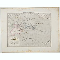
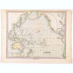
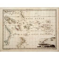
Oceania.
Uncommon map of Pacific ocean prepared by Francesco Costantino Marmocchi. Above the map "Geografia Commerciale". From "Il Globo Atlante di carte Geografich...
- $50 / ≈ €47
Place & Date: Genova, Paolo Rivara fu Giacomo, 1858
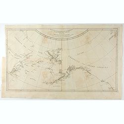
Kaart van de Noord-West kust van Amerika en de Noord-Oost kust van Asia. . .
A uncommon issue of this important map of the Northern Pacific and contiguous coasts of America and Asia, published in 'Reize rondom de Waereld door James Cook', a Dutch ...
- $1000 / ≈ €936
Place & Date: Leyden, Amsterdam & The Hague: Honcoop, Allart & van Cleef, 1795-1801
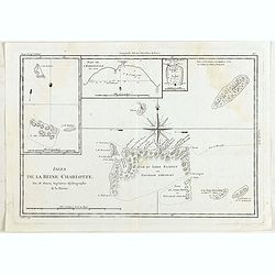
Isles de la Reine Charlotte.
Four charts on one page including chart of Nendö Island, largest of the Santa Cruz Islands, part of the Solomon Islands group, as mapped by Captain Cartaret in 1767, the...
- $40 / ≈ €37
Place & Date: Paris, 1790
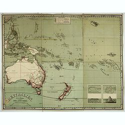
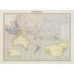
Australien, von E. van Sÿdow.
Large School wall map of Australia and New Zealand, including some islands in the Pacific, including Hawaii. Prepared by Emil von Sydow (1812 - 1873), who was a Prussian ...
- $1000 / ≈ €936
Place & Date: Gotha, H. Kiepert, 1873
![[The attack by Schouten and his men on a waka.]](/uploads/cache/39658-250x250.jpg)
[The attack by Schouten and his men on a waka.]
Scarce print on French text sheet showing the attack by Schouten and his men on a waka.From a description of the voyage of Le Maire and Schouten included in the first Fre...
- $200 / ≈ €187
Place & Date: Amsterdam, 1622
![[Locals.]](/uploads/cache/39659-250x250.jpg)
[Locals.]
Scarce print on French text sheet showing a copper engraved view of locals in Oceania.From a description of the voyage of Le Maire and Schouten included in first French t...
- $150 / ≈ €140
Place & Date: Amsterdam, 1622
![[2 Sheets] Carte Générale de l'Océan Pacifique Dressée Par Mr. C. A. Vincendon-Dumoulin. . . Pl. 1. N° 1092. / Ocean Pacifique Feuille 2. . . Pl. 2. N° 1093.](/uploads/cache/26731-250x250.jpg)
[2 Sheets] Carte Générale de l'Océan Pacifique Dressée Par Mr. C. A. Vincendon-Dumoulin. . . Pl. 1. N° 1092. / Ocean Pacifique Feuille 2. . . Pl. 2. N° 1093.
Two sea charts depicting the Pacific Ocean, with nice detail of Hawaii. Sheet 1 shows the south east Asian region. The second North America and part of South America. Pre...
- $900 / ≈ €842
Place & Date: Paris, 1845, updated for 1884
Ocean Pacifique Partie Ouest.
Large French sea chart featuring the western part of the Pacific Ocean with Australia, New Zealand, New Guinea, Philippines, till Korea and Japan, corrected in 1929.On th...
- $450 / ≈ €421
Place & Date: France, 1909-1929
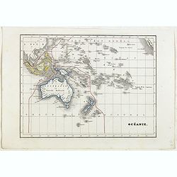
Océanie.
Detailed map of Australia, New Zealand, Indonesia and the Pacific. With a color key indicating English, French, Dutch, Spanish and Portuguese possessions in the region. F...
- $100 / ≈ €94
Place & Date: Paris, 1865
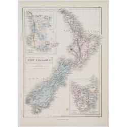
New Zealand.
A detailed lithographed map of New Zealand. With in upper left corner inset-map of Western Australia and in lower right hand corner a map of Van Diemens Land. Published b...
- $100 / ≈ €94
Place & Date: Edinburg, 1874
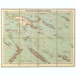
Principaux archipels d'Oceanie.
Detailed folding map of seven principal island groups in the South Pacific represented at various scales. The number and title are also on the outside front of the sheet....
- $120 / ≈ €112
Place & Date: Paris, ca. 1930
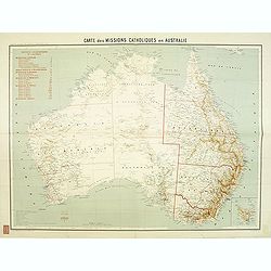
Carte des missions Catholiques en Australie.
Rare and detailed map of Australia (Scale 1:5 000 000) showing Catholic dioceses and bishops' residences, but not missions, on a topographic basis. Relief is shown by hac...
- $900 / ≈ €842
Place & Date: Lyon / Paris, 1906
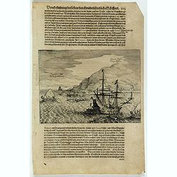
Cocos Insel Cocos Insula / Verräter Insel Insula proditorum.
Scarce print (148x204mm.) on a German text sheet showing the landing of Le Maire and Schouten at Cocos Island in May 1616 (today’s Tafahi in the Tonga Islands). Named b...
- $150 / ≈ €140
Place & Date: Frankfurt, M.Merian, 1631
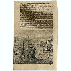
![[The attack by Schouten and his men on a waka.]](/uploads/cache/39754-250x250.jpg)
[The attack by Schouten and his men on a waka.]
Scarce print (145x210mm.) on a German text sheet showing the attack by Schouten and his men on a waka.The page is taken from a first edition of Johann Ludwig Gottfried's ...
- $150 / ≈ €140
Place & Date: Frankfurt, M.Merian, 1631
Vligen Insel.
Scarce print (168x200mm.) on a German text sheet showing the attack of mosquitos on Schouten's ship.The page is taken from a first edition of Johann Ludwig Gottfried's &q...
- $75 / ≈ €70
Place & Date: Frankfurt, M. Merian, 1631
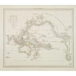
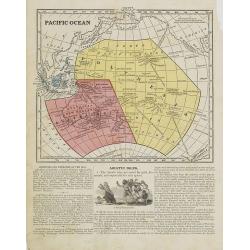
Oceana or Pacific Ocean.
A lovely detailed map of the Pacific, centered on Hawaii, from an early edition of Tanner's New Universal Atlas. From Russian America (AK) to Patagonia, and from New Zeal...
- $100 / ≈ €94
Place & Date: Philadelphia, ca 1840
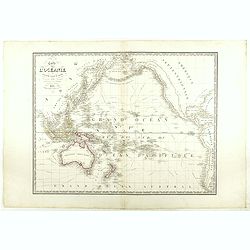
Carte de l'Océanie ou cinquième partie du Monde.
Early detailed map of the Southern part of the Pacific, extending from Southeast Asia, Australia and New Zealand to Hawai'i and the West Coast of the United States and Me...
- $270 / ≈ €253
Place & Date: Paris, 1834
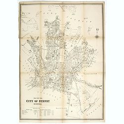
Map of the city of Sydney. New South Wales.
Early street plan of the city of Sydney, showing parishes, municipalities, buildings, public parks and recreation reserves. Lithographed and published by the dept of Land...
- $2000 / ≈ €1871
Place & Date: Sydney, 1895
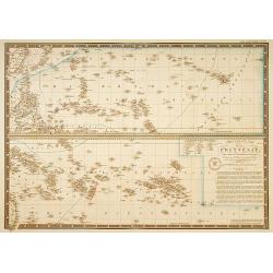
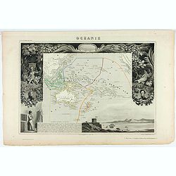
Océanie.
A very decorative 19th century map of the Pacific Ocean, with hand colored lines indicating the extent of Polynesia, Micronesia, Melanesia, and Malaysia (or Southeast Asi...
- $120 / ≈ €112
Place & Date: Paris, 1850
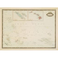
Carte particuliere de la Polynesie. . .
Prepared by A.Brué in 1826 and published by Charles Piquet. Two maps on one sheet, showing the Polynesian islands. In upper left an inset map of Formosa and the coast o...
- $150 / ≈ €140
Place & Date: Paris, 1834
Océanique Oriente.
Drom the Carolines to New Zealand and east to Pitcairn Island with Australia from Torres Strait to Tasmania. Engraved by J.B.Tardieu and prepared by Giraldon.From Conrad ...
- $300 / ≈ €281
Place & Date: Paris, 1809/1812
![Vue d'un Rocher troué de la Nouvelle Zélande. [Tome III Pl. 8.]](/uploads/cache/29073-250x250.jpg)
Vue d'un Rocher troué de la Nouvelle Zélande. [Tome III Pl. 8.]
A view of a New Zealand landscape and seascape through a hollow rock. Engraved by Demouchy. From the French edition of James Cook's first voyage entitled Relation des voy...
- $75 / ≈ €70
Place & Date: Paris, 1773
Océanie.
Small map of Australia, New Zealand and the Pacific. The area is divided in different parts. Lithographed by C.Callewaert from Brussels.
- $80 / ≈ €75
Place & Date: Bruxelles, c. 1880
Océanie ou Australasie et Polynesie . . .
Detailed map of Oceania, prepared by A. H. Basset, rue Saint-Jacques, no. 64, Paris and published in Atlas classique et Universel de Géographie . . . .The engraver of th...
- $150 / ≈ €140
Place & Date: Paris, A.H. Basset, 1828
Carte de la Mer comprise entre l'Australie, la Nelle. Zélande et la Nelle.
Sea chart of the Pacific Ocean between Australia, New Zealand and New Caledonia. Including the towns of Sydney, Brisbane. The northern tip of New Zealand in lower right c...
- $350 / ≈ €328
Place & Date: Paris, 1872 updated for 1888
![[Australia and New Zealand map with Ottoman script.]](/uploads/cache/44313-250x250.jpg)
[Australia and New Zealand map with Ottoman script.]
Post card size map in Ottoman script showing Australia and New Zealand prepared by Mehmet EŞREF in a small atlas : عمومولاياةىشهانيىحاوىكوچكا�...
- $225 / ≈ €211
Place & Date: Istanbul, 1325 or 1909
![[Australia, New Zealand and Oceania map with Ottoman script]](/uploads/cache/44319-250x250.jpg)
[Australia, New Zealand and Oceania map with Ottoman script]
Postcard size map in Ottoman script showing Australia, New Zealand and Oceania prepared by Mehmet EŞREF in a small atlas : عمومولاياةىشهانيىحاوىك�...
- $175 / ≈ €164
Place & Date: Istanbul, 1325 or 1909
Les divers archipels de L'Oceanie.
Very detailed map from Atlas Sphéroïdal & Universel de geographie , Prepared by F.A.Garnier and edited by Jules Renouard, rue de Tournon, Paris. Uncommon map with d...
- $150 / ≈ €140
Place & Date: Paris, 1861
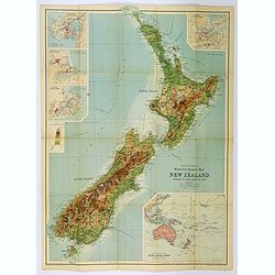
Bartholomew's Touring Map of New Zealand.
A full color map. 'Reduced Survey Map of New Zealand, colored to Show Height of Land'. With insets of Auckland Harbour, Wellington and Port, Christchurch and Port Lyttelt...
- $90 / ≈ €84
Place & Date: Edinburgh, 1935
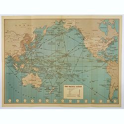
Hammond's War Map.
Drawn and published in early 1942 by C. S. Hammond & Co. in direct response to the bombing of Pearl Harbour, this is one of the most detailed USA maps of the Pacific ...
- $200 / ≈ €187
Place & Date: New York, 1943

Océanie.
Decorative map of the Pacific Ocean including Indonesia, Australia, New Zealand and California. Lower right inset map Détails de la Nouvelle Galles Méridionale , includ...
- $120 / ≈ €112
Place & Date: Paris 1880
Océanie dresée par C.V.Monin.
Fine and uncommon map including Australia, New Zealand, Indonesia, with inset maps of New Zealand, Victoria/New South Wales and Western Australia including Albany and Per...
- $150 / ≈ €140
Place & Date: Paris, 1875
Océanie.
A very decorative 19th century map of the Pacific Ocean, with hand colored lines indicating the extent of Polynesia, Micronesia, Melanesia, and Malaysia (or Southeast Asi...
- $200 / ≈ €187
Place & Date: Paris, 1850
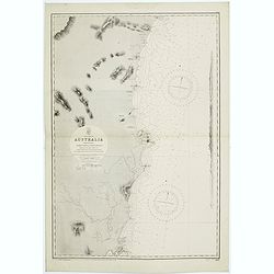
Australie (Côte Est) Feuille N°10 Partie comprise entre La Baie Jervis et le Cap Everard . . .
Large French sea chart featuring the eastern coast of Australia. Engraved by J.Millian. The chart is based on surveys by the British Captn. F.W. Sidney, Staff Comr., H.J....
- $750 / ≈ €702
Place & Date: Paris, 1874
Pacific Ocean.
Map of the Pacific Ocean with its Polynesian islands, and New Zealand and Australia. From Sidney E. Morse''s: System of Geography for the use of schools , published by Ha...
- $30 / ≈ €28
Place & Date: New York, 1855
![[Set of two maps of the Pacific Ocean with transportation lines, with Ottoman script]](/uploads/cache/44327-250x250.jpg)
[Set of two maps of the Pacific Ocean with transportation lines, with Ottoman script]
Two post card size maps showing the Pacific Ocean with transportation lines. The maps are in Ottoman script prepared by Mehmet EŞREF in a small atlas : ...
- $200 / ≈ €187
Place & Date: Istanbul, Şirket-i Mürettibiye ve Karacoğlu Matbaas&#
Nuova Guinea e Nuova Galles ed Isole Adjacenti
Map of the South Pacific, showing the sailing routes to the South Pacific by Carteret and Byron, but most importantly the discoveries made by Captain Cook, 1768-1771. The...
- $1750 / ≈ €1638
Place & Date: Venise, 1794-1796
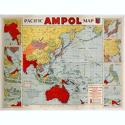
Pacific AMPOL Map
A large and very colorful World War II era map of the Pacific Ocean produced with the complements of the Australian Motorists Petrol Co. Ltd. The map itself shows the Pac...
- $1000 / ≈ €936
Place & Date: Australia, ca 1942
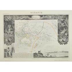
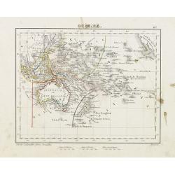
AUSTRALIE
Detailed folding maps of Australia. In upper left corner "Atlas Universal" and in upper right corner "Carte 78".In lower left "Dessiné: le trait...
- $150 / ≈ €140
Place & Date: Paris, ca. 1930
Australien (Südland) auch Polynesien oder Inselwelt..
SECOND EDITION of the Johann Walch map of Australasia and the South Pacific. Australia letteredNeu Holland, the name given to it by Able Tasman that was still in use unti...
- $1100 / ≈ €1029
Place & Date: Augsburg, 1802-1820
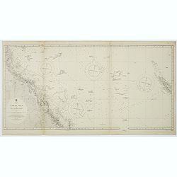
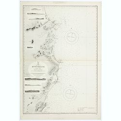
Australia, Coral Sea and Great Barrier Reefs shewing the inner and outer routes to Torres Strait. Sheet 1. . .
Large scale chart representing the Great Barrier Reef and the Coral Sea showing routes to the Torres Strait. Sheet 1.First published at the Admiralty 1860 with new editio...
- $150 / ≈ €140
Place & Date: London, 1869-1943
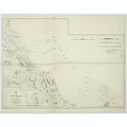
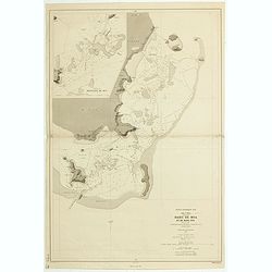
Sheet XI East coast of Australia - Sandy Cape to Keppel isles surveyed by Staff Commr. E.P. Bedwell, Navg. Lieutt. E.H.S. Bray, and Navg. Sub. Lieutt. E.R. Connor, 1870
Large chart representing East coast of Australia from Sandy Cape to Keppel isles surveyed by Staff Commr. E.P. Bedwell. With two inset charts of Pancake Creek. Scale 1:24...
- $150 / ≈ €140
Place & Date: London, 1883-1944
![Plan de la Baie Laplace [with] Esquisse du Port Western [with] Plan des Iles Forestier [with] Esquisse du Port Champagny.](/uploads/cache/46372-250x250.jpg)
Plan de la Baie Laplace [with] Esquisse du Port Western [with] Plan des Iles Forestier [with] Esquisse du Port Champagny.
Four maps on one sheet, Laplace Bay, Western Harbour, Forestier islands and Champagny Harbour, from Voyage de découvertes aux terres Australes by François Péron, 1824....
- $200 / ≈ €187
Place & Date: Paris, 1824
![Plan de la partie sud des Iles Furneaux [with] Carte générale de la Partie Sud-Est de la Terre de Diémen . . .](/uploads/cache/46365-250x250.jpg)
Plan de la partie sud des Iles Furneaux [with] Carte générale de la Partie Sud-Est de la Terre de Diémen . . .
Two maps on one sheet, on top a map of the southern portion of Cape Barren Island, Clarke Island, and islets in the southern part of the Furneaux Group.With in lower part...
- $200 / ≈ €187
Place & Date: Paris, 1824
![Australia, E. coast - Queensland Percy isles to Whitsunday I. chiefly from a joint Admiralty & Colonial survey by Staff Commander Bedwell, R.N. 1873 to 1879 [1945]](/uploads/cache/36212-250x250.jpg)
Australia, E. coast - Queensland Percy isles to Whitsunday I. chiefly from a joint Admiralty & Colonial survey by Staff Commander Bedwell, R.N. 1873 to 1879 [1945]
Large chart representing East coast of Australia with Queensland from Percy isles to Whitsunday Island, with inset of Beverley Islands Anchorage. Scale 1:74,000. in lower...
- $150 / ≈ €140
Place & Date: London, 1882-1945
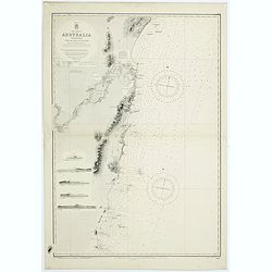
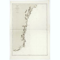
East coast of Australia. New South Wales. Sheet VII, Coffs Islands to Evans Head surveyed by Comr. Fredk. W. Sidney R.N. assisted by E.P. Bedwell & J.T. Gowlland, Masters & S. Guy, 2nd Master R.N. 1864-5
Large chart representing East coast of Australia with New South Wales including Coffs Islands to Evans Head surveyed by Comr. Fredk. W. Sidney R.N. First published at the...
- $150 / ≈ €140
Place & Date: London, 1907-1943
![Nouvelle-Hollande Nelle Galles du sud. Vue d'une partie de la ville de Sydney capitale des Colonies Anglaises aux Terres Australes . . . [plate XXXVII]](/uploads/cache/46359-250x250.jpg)
Nouvelle-Hollande Nelle Galles du sud. Vue d'une partie de la ville de Sydney capitale des Colonies Anglaises aux Terres Australes . . . [plate XXXVII]
Important view of Sydney Cove from Dawes Point looking eastward from Voyage de découvertes aux terres Australes by François Péron, 1824. This is one of the earliest de...
- $1100 / ≈ €1029
Place & Date: Paris, 1824
![Nouvelle-Hollande: Nouvelle Galles du sud. -Dasyure à longue queue. [plate XXXIII]](/uploads/cache/46355-250x250.jpg)
Nouvelle-Hollande: Nouvelle Galles du sud. -Dasyure à longue queue. [plate XXXIII]
Plate illustrating the Dasyure, who lives in Tasmania and south-eastern Australia. Plate by Lesueur, from Voyage de découvertes aux terres Australes by François Péron,...
- $200 / ≈ €187
Place & Date: Paris, 1824
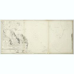
Sheet XII East coast of Australia Queensland Keppel Isles to Percy Isles. . .
Large chart representing east coast of Australia's Queensland showing Keppel Isles to Percy Isles with relief shown by hachures, spot heights and bathymetric soundings. S...
- $150 / ≈ €140
Place & Date: London, 1932-1944
Sheet V East coast of Australia. New South Wales Evans Head to Danger Pt. surveyed by Comr. Fredk. W. Sidney R.N. . . 1864-5. . .
Large chart representing East coast of Australia with New South Wales including Evans Head to Danger Pt. surveyed by Comr. Fredk. W. Sidney R.N. from 1864 - 1865. First p...
- $150 / ≈ €140
Place & Date: London, 1866-1943
Australia - East coast Queensland Keppel Bay and Islands surveyed by staff Commr. J.Jeffery. . . 1864. . .
Large chart representing East coast of Australia with Queensland including Keppel Bay and Islands surveyed by Comr. J.Jeffery in 1864. First published at the Admiralty 3r...
- $150 / ≈ €140
Place & Date: London, 1866-1943
![Nouvelle-Hollande. Gnoung-A-Gnougn-A, Mour-Re-Mour-Ga ( Dit Collins). [plate XVII]](/uploads/cache/46280-250x250.jpg)
Nouvelle-Hollande. Gnoung-A-Gnougn-A, Mour-Re-Mour-Ga ( Dit Collins). [plate XVII]
A portrait of a male Tasmanian Aboriginal Gnoung-A-Gnougn-A, Mour-Re-Mour-Ga ( Dit Collins) by Lesueur, from Voyage de découvertes aux terres Australes by François Pér...
- $100 / ≈ €94
Place & Date: Paris, 1824
Sheet VI East coast of Australia. New South Wales Tacking Point to Coffs Islands surveyed by Comr. Fredk. W. Sidney R.N. . . 1862 - 1864. . .
Large chart representing East coast of Australia with New South Wales including Tacking Point to Coffs Islands surveyed by Comr. Fredk. W. Sidney R.N. from 1862 - 1864. F...
- $150 / ≈ €140
Place & Date: London, 1939-1942
ILE UVEA CROQUIS DES BAIES DE MUA ET DE MATA UTU.
Mata-Utu is the capital of Wallis and Futuna, an overseas collectivity of France. It is located on the island of Uvéa, in the district of Hahake, of which it is also the...
- $80 / ≈ €75
Place & Date: Paris, 1887
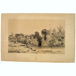
Entrée de la Riviere de Paiou.
A lithograph showing the entrance to the river Paiou on Vanikoro Island, a part of the Santa Cruz Group and the Solomon Islands in the Pacific. Plate 97 taken from the 'V...
- $50 / ≈ €47
Place & Date: Paris, 1842
Océanie.
Detailed map of Oceania, including Indonesia and the Pacific Ocean with Hawaii, prepared by Charles V. Monin (fl.1830-1880) a French cartographer of Caen and Paris. Publi...
- $50 / ≈ €47
Place & Date: Paris, 1845
![Terre de Diemen. Bara-Ourou. [plate VIII]](/uploads/cache/46271-250x250.jpg)
Terre de Diemen. Bara-Ourou. [plate VIII]
A portrait of the Tasmanian Aboriginal Bara-Ourou, after the original sketches by Lesueur, from Voyage de découvertes aux terres Australes by François Péron, 1824.The ...
- $150 / ≈ €140
Place & Date: Paris, 1824
![Terre de Diemen. Grou-Agara. [plate X]](/uploads/cache/46273-250x250.jpg)
Terre de Diemen. Grou-Agara. [plate X]
A portrait of the Tasmanian Aboriginal Grou-Agara, after the original sketches by Lesueur, from Voyage de découvertes aux terres Australes by François Péron, 1824.The ...
- $100 / ≈ €94
Place & Date: Paris, 1824
![Terre de Diemen. Paraberi. [plate XI]](/uploads/cache/46274-250x250.jpg)
Terre de Diemen. Paraberi. [plate XI]
A portrait of the Tasmanian Aboriginal Paraberi, after the original sketches by Lesueur, from Voyage de découvertes aux terres Australes by François Péron, 1824.The Fr...
- $200 / ≈ €187
Place & Date: Paris, 1824
![Terre de Diemen. Arra-Maida. [plate XII]](/uploads/cache/46275-250x250.jpg)
Terre de Diemen. Arra-Maida. [plate XII]
A portrait of a female Tasmanian Aboriginal Arra-Maida, after the original sketches by Lesueur, from Voyage de découvertes aux terres Australes by François Péron, 1824...
- $100 / ≈ €94
Place & Date: Paris, 1824
![Nouvelle-Hollande: Ile Bernier. - Kanguroo a Bandes [plate XXVII]](/uploads/cache/46349-250x250.jpg)
Nouvelle-Hollande: Ile Bernier. - Kanguroo a Bandes [plate XXVII]
Plate illustrating Kanguroo a Bandes by Lesueur, from Voyage de découvertes aux terres Australes by François Péron, 1824.The French expedition under Nicolas Baudin, wa...
- $300 / ≈ €281
Place & Date: Paris, 1824