
Cochin (today: Ernakulam)
Small but charming 18th water color on paper depicting Cochin (today : Ernakulam) was from 1500, when the first Portuguese fleet called on its port, a firm ally of the Po...
Date: India? c.1750
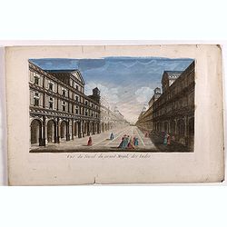
Vue du serail du grand Mogol, des Indes.
Optical print of a Mogul Palace in India. Probably published by or after Jacques Chereau, who was a well-known publisher of optical prints, established in rue St. Jacques...
- $200 / ≈ €170
Date: Paris, ca. 1750
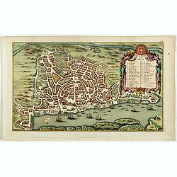
Grundriss von Goa.
A beautifully detailed and engraved town-plan of the Portuguese colony of Goa in India, with a number key (1-29) to the city's major monuments and sites, enclosed in a de...
Date: Amsterdam, 1752
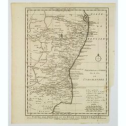
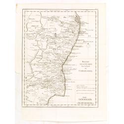
Toneel des Oorlogs op de Kust van Choromandel . . .
The detailed map refers to the Carnatic (or Karnatic) Wars (1746-1763), a series of military conflicts in the middle of the 18th century in India. These conflicts involve...
Date: Amsterdam, 1756
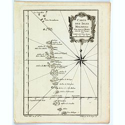
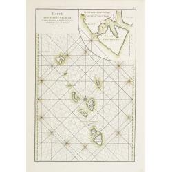
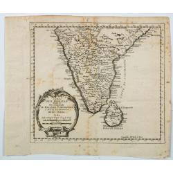
Carte des Isles Maldives.
A small detailed map of the Maldives, with rhumb lines and a large compass rose. Includes a decorative title cartouche. One of the maps produced by Nichlas Bellin for Pre...
Date: Paris, 1757
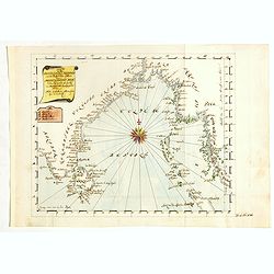
Karte von den Bengaslishen Meerbussen . . .
Manuscript map including Ceylon, south of India, Bengal gulf with Burma (Myanmar), Thailand and northern tip of Sumatra. Very decorative and colorful compass rose in cent...
Date: Germany, ca. 1760
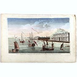
Vue des Magasins de la Compagnie des Indes à Pondichéry, de l'Amirauté et de la maison du Gouverneur.
Optical print of the French East India Company's warehouses, the Admiralty and the Governor's House at Pondicherry in Tamil Nadu. Pondicherry, on the Coromandel Coast sou...
- $300 / ≈ €256
Date: Paris, ca 1760
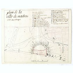
Plan de la ville de Madras et de ses attaques.
Manuscript map, in black, brown and red ink, showing the fortifications of the city of Madras, now Chennai, on the east coast of India, north of Pondicherry.Showing the c...
- $2000 / ≈ €1704
Date: Paris, ca 1760
![East Indies. {India]](/uploads/cache/38623-250x250.jpg)
East Indies. {India]
Uncommon miniature map of India, engraved by Thomas Kitching for "A New General and Universal Atlas Containing Forty five Maps by Andrew Dury".This miniature at...
- $100 / ≈ €85
Date: London, 1761-1763
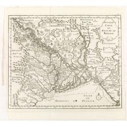
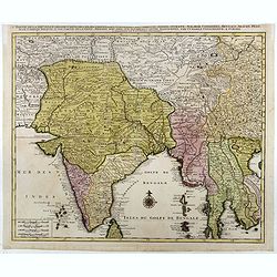
Nouvelle carte du royaume de Bengale.
Map of Bengal Kingdom prepared by J.N.Bellin.
Date: Amsterdam, Leipzig, 1763
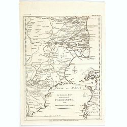
Theatre de la guerre sur la coste de Coromandel.
Map of Coromandel coast prepared by J.N.Bellin.
Date: Amsterdam, Leipzig, 1763
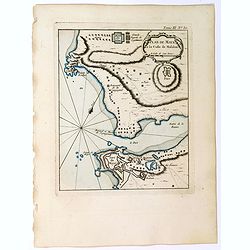
Plan de Maye a la Coste de Malabar.
From Bellin's "Le Petit Atlas Maritime", a plan of the bay of Maye, off the Malabar coast of southern India. Map relief shown pictorially. Shows settlements, po...
- $100 / ≈ €85
Date: Paris, 1764
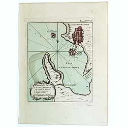
Baye Ville et Forts d'Andarajapour a la Coste de Malabar.
From Bellin's popular "La Petit Atlas Maritime", showing the bay, fort and town of Andarajapour in the Malabar region of India. The map is furnished with a comp...
- $110 / ≈ €94
Date: Paris, 1764
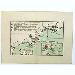
Coste de Coromandel depuis Gondagamas jusqu'a Narzapour.
This map is taken from Bellin'spopular 'Petit atlas maritime'. It shows a portion of the Indian coastline in the region of Coromandel from Montepdly through Mazulipatam o...
- $110 / ≈ €94
Date: Paris, 1764
Plan de Maye a la Coste de Malabar.
From Bellin's 'Le Petit Atlas Maritime', a plan of the bay of Maye, off the Malabar coast of southern India. Relief shown pictorially. It shows settlements, ports, and ma...
Date: Paris, 1764
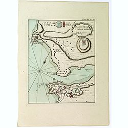
![Plan de Gingy, ville et forteresse d'Asie . . . [An Early Manuscript Map of Pondicherry Prior To Its Reconstruction After The Seven Years War.]](/uploads/cache/43006-250x250.jpg)
Plan de Gingy, ville et forteresse d'Asie . . . [An Early Manuscript Map of Pondicherry Prior To Its Reconstruction After The Seven Years War.]
An early manuscript map of Gingy shortly after The Seven Years War, when the French took possession of large part of India.With an extensive key to the left.Gingee Fort o...
- $1500 / ≈ €1278
Date: Paris, 1765
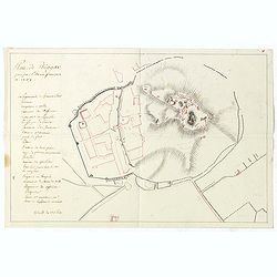
Plan de Thiagar, prise par l'arméé française en 1759.
An early manuscript map of Thiagar. With an extensive unfinished key to the left. The map was drawn shortly after the end of the Seven Years War, when the French took pos...
- $750 / ≈ €639
Date: Paris, 1769
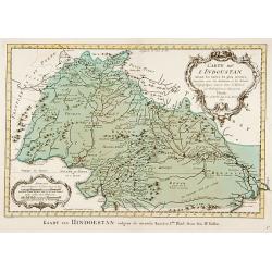
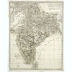
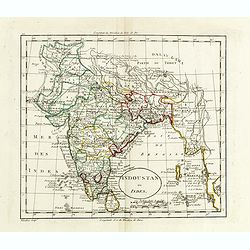
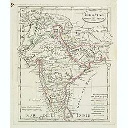
Carte de L'Indoustan. . .
Uncommon edition of this fine map of the northern part of India.From Atlas Portatif pour servir a l'intelligence de l'Histoire Philosophique et Politique des etablissemen...
- $150 / ≈ €128
Date: Amsterdam, 1773

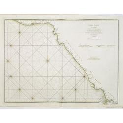
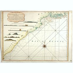
Carte réduite de l'Océan Oriental, depuis Le Cap de Bonne Espérance jusqu'à l'Isle Formose.
French chart covering the seas between the Cape of Good Hope and Taiwan and the West Coast of Australia. Prepared by Jacques-François L'Abbé Dicquemare (1733-1789). Lat...
Date: Paris, Brest, chez Demonville, 1775

Carte de la Côte de Guzerat, Du Golf de Cambaye et des Côtes de Concan et De Canara.
French sea chart of West India from Gujarat to Mangalore. With inset chart Plan de la Rivière de Surate.Prepared by Jacques-François L'Abbé Dicquemare (1733-1789). La...
Date: Paris, ca 1775
Carte Plate qui comprend La partie septentrionale de LA Cöte de Coromandel et les Côtes de Golconde , D' Orcha et de Bengale.
French chart of Coromandel in India. West to the top.Latitude and longitude scales, compass rose and system of rhumb lines, soundings near coast and in bay areas.D' Aprè...
- $150 / ≈ €128
Date: Paris, Brest, chez Demonville, 1775
Carte des Isles Nicobar... (with) Plan particulier du Port compris entre les Isles Nacaveri, Souri, et Tricutte.
French chart of Isles of Nicobar in Gulf of Bengal near Birmanie and Sumatra. Prepared by Jacques-François L'Abbé Dicquemare (1733-1789). Latitude and longitude scales,...
Date: Paris, Brest, chez Demonville, 1775
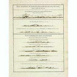
Vues diverses du fort de l'Agouade pres de l'isle de Goa . . . Sumatra . . .
French sea sea chart with 9 coastal views near Goa in India and Sumatra. The titles above the main profiles reading as following : Vues diverses du fort de l'Agouade pre...
- $200 / ≈ €170
Date: Paris, Brest, Demonville, 1775
![The country Coromandel from the Coleroon to Cape Comorin. . . [with] The carnatic from the Pennar to the Coleroon. .](/uploads/cache/48363-250x250.jpg)
The country Coromandel from the Coleroon to Cape Comorin. . . [with] The carnatic from the Pennar to the Coleroon. .
Coromandel from the Coleroon to Cape Comorin. Elegant map in two sheets compiled for the East-India Company. In lower right margin : Writing by W. Harrison.
- $300 / ≈ €256
Date: London, 1778
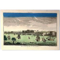
Vue de la Pondichery dans les Indes Orientales
Pondicherry is the capital city of Indian union territory of Puducherry. Pondicherry is situated in Puducherry district of the union territory in India. The vue was produ...
Date: Paris, 1780
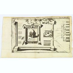
Madirass. Ville Indienne don't les Maisons sont basses & plates.
A small plan of Fort St. George, Madras/Chennai in India. It highlights both inner and outer fortifications, fences, town entrances and the sea, together with the church,...
Date: Unknown, ca 1780
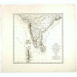
Carta Dell' Indostan che comprende il Malabar, Coromandel, e tutta la penisola Dell' India.
This is from a scarce Italian edition of French cartographer Jacques-Nicholas Bellin’s map of southern India and the island of Ceylon (Sri Lanka). The map extent is fro...
Date: Paris, ca 1780
An Accurate Map of the Coast of Coromandel, from Fort St. David to Cape Comorin.
This is a finely engraved map of the south eastern Indian Coromandel coastal regions & the north west Sri Lankan coast through the Gulf of Manar. It was engraved by J...
Date: London, 1782
![ИНДIИ [Map of India in Cyrillic].](/uploads/cache/44340-250x250.jpg)
ИНДIИ [Map of India in Cyrillic].
A map of India. This Cyrillic version of the map appeared in one of the first world atlases published in Russia, "Novy Atlas, ili sobranie kart ..." which trans...
Date: Paris / St.Petersburg, ca. 1790
Partie de la nouvelle grande carte des Indes Orientales. . .
This is the northwest sheet of a four-sheet map of Southern and Southeast Asia, showing the Bay of Bengal and extending from the Pakistani border across India to the Indo...
Date: Amsterdam, 1792

A chart of the northern part of the Indian Ocean..
Complete title in upper right "A Chart of the Northern Part of the Indian Ocean, Containing a Part of the Coast of Africa from Magadasho River to the Straits of Bab-...
Date: London 1794
The Coast of India, from Point Gordeware to the Ganges Comprehending Part of the Coast of Golconda . . .
Detailed sea chart of the coast of India, from the mouths of the Ganges Rivers in the northeast to Point Gordeware in the south west. Includes numerous sailing channels a...
- $400 / ≈ €341
Date: London, 1794
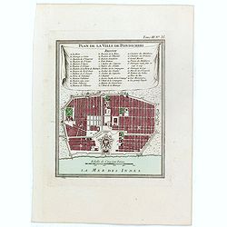
Plan de la ville de Pondicheri.
The first detailed French plan of Pondicherry. In the lower part, a lettered and numbered key and the coat of arms of Mr. Joseph-François Dupleix.The Compagnie des Indes...
Date: Paris, 1800

Recueil de cartes géographiques pour la description de l'Indostan . . .
First French edition, the maps revised by Jean Nicholas Buache. The English original edition was published in London in 1783 by Brown under the title "Memoir of a ...
Date: Paris, Poignée, an VIII = 1800
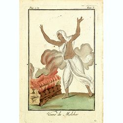
Venue du Malabar.
Originally hand-colored mezzotint of a widow of Malabar engraved by Félix Mixelle and Lachaussée Jeune after Jacques Grasset de Saint-Sauveur.As an etcher, drawer and w...
Date: Paris,1801-1806
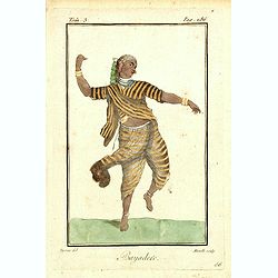
Bayadere.
Originally hand-colored mezzotint of a Temple Dancer engraved by Félix Mixelle and Lachaussée Jeune after Jacques Grasset de Saint-Sauveur.As an etcher, drawer and writ...
Date: Paris,1801-1806
Charte von Ostindien disseits des Ganges im gegenwärtigen Zustande.
A uncommon issue of this detailed map of India, including Ceylon.
Date: Weimar, 1807
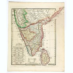
The Southern provinces of Hindoostan . . .
An attractive map showing Hindoostan and Ceylon. Shows towns, rivers, mountains, lakes, etc. In pretty original wash colors. Robert Wilkinson was active in London as a ca...
Date: London, 1808
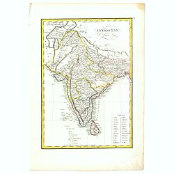
Indoustan ou Inde.
Map of India. The map is based on the Paris Meridian, only in 1884, at the International Meridian Conference in Washington DC, the Greenwich Meridian was accepted.Engrave...
- $100 / ≈ €85
Date: Paris, c. 1810
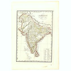
![Hindostan [India]](/uploads/cache/49208-250x250.jpg)
Hindostan [India]
A fine copper engraved map of Hindoostan (now India) drawn and engraved by Alexander Findlay and published by Thomas Kelly, London in 1814
Date: London, 1814
El Indostan por D. Juan Lopez.
Uncommon map of India and Shri Lanka published by Juan Lopez (1765-1830) and included in his "Atlas Universal o collection de mapas nuevos. . ." first published...
Date: Madrid, 1817
El Indostan por D. Juan Lopez.
Uncommon map of India and Shri Lanka published by Juan Lopez (1765-1830) and included in his "Atlas Universal o collection de mapas nuevos. . ." first published...
Date: Madrid, 1817
Indostan gia impero del mogol. . .
Charming map of India with Ceylon from the rare atlas Atlante Tascabile o sia Serie di Num. XXI Cartine Geografiche nelle quali si rappresenta in ristretto lo Stato Attua...
- $150 / ≈ €128
Date: Rome, 1823
Carte De L'Indostan Servant à Indiquer Les Possessions Françaises En Asie.
Map of a part of Asia, with Sri Lanka, From " Nouvel Atlas du royaume de France, ou cartes détaillées des Gaules, de la France à l'époque de 1789, des 86 départ...
Date: Paris, 1826
![[ LXXII. Divertimenti de' serpenti ].](/uploads/cache/34981-250x250.jpg)
[ LXXII. Divertimenti de' serpenti ].
Aquatint depicting snake charmers engraved by D.Klemi-Bonatti, Plate N°60.From Giulio Ferrario's work Le Costume Ancien et Moderne ou Histoire du gouvernement, de la mil...
- $50 / ≈ €43
Date: Milan, 1827
![[British soldiers in India].](/uploads/cache/14500-250x250.jpg)
[British soldiers in India].
A decorative print showing a group of English soldiers being attacked by Indian locals. After design of A. van Eschen. From a series Englischer Dienst. 10 Service d'Angle...
Date: Germany, c.1830
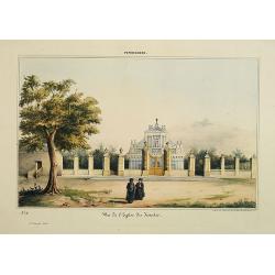
Pondichery - Vue de l'Eglise des Jésuites.
Constructed in 1791, it is regarded as the main mother church of Roman Catholic Archdiocese of Pondicherry and Cuddalore. To one’s surprise, this famous church in Pondi...
- $300 / ≈ €256
Date: Paris, 1843
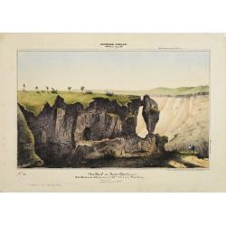
Southern - Concan.. - Nalkind or Kates Point..
Lithography representing a rocky landscape in the Western Ghats. Plate N° 12. From Souvenirs d'un voyage dans l'Inde, exécuté de 1834 à 1839, by A. Delessert.Adolphe ...
- $300 / ≈ €256
Date: Paris, 1843
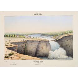
Southern - Concan.. - The falls of Gokank..
Hand colored lithography representing a view of the Gokak Falls, located on the Ghataprabha River. The Ghataprabha river in India is an important right-bank tributary of ...
Date: Paris, 1843
![[7 Indian Patna water colors of crafts.]](/uploads/cache/43663-250x250.jpg)
[7 Indian Patna water colors of crafts.]
Seven Company school, also called Patna painting, style of miniature painting that developed in India in the second half of the 18th century in response to the tastes of ...
- $750 / ≈ €639
Date: India, ca.1850
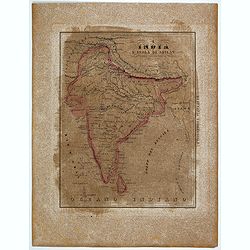
L'India e L'Isola di Seilan.
Uncommon map of India prepared by Francesco Costantino Marmocchi. Above the map "Geografia Commerciale". From "Il Globo Atlante di carte Geografiche compil...
Date: Genova, Paolo Rivara fu Giacomo, 1858

Vicariati E prefetture apostoliche nelle Indie Orientalis
Map showing the boundaries of Catholic dioceses in South and Southeast Asia in 1850s, with some detail of India, Malacca, Thailand and Hainan. This finely engraved and be...
- $500 / ≈ €426
Date: Rome, 1858-1859
![Bay of Bengal, compiled chiefly from government survey.. [2 sheets]](/uploads/cache/23495-250x250.jpg)
Bay of Bengal, compiled chiefly from government survey.. [2 sheets]
Large scale chart in 2 sheets focused on the Bay of Bengal.It covers Sri Lanka, the whole Indian eastern coast, the seacoast of Bangladesh, Myanmar and Thailand as far as...
- $1200 / ≈ €1023
Date: London (1863), corrections to 1871

Un Reclutatore in India. Papagallo No. 42. Anno VI.
A British recruter in India. Design by Augusto Grossi. Taken from the Italian satirical newspaper Il Papagallo, a satirical magazine founded in January 1873 by Augusto Gr...
Date: Bologne, 1878
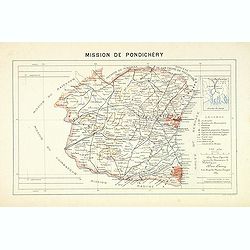
Mission du Kouang-Ton.
Important map of Pondichery in India, prepared by Adrien Launay, who was a French Missionary and later chronicler of the history of the French Missions in Indo-China at e...
Date: Lille, 1890
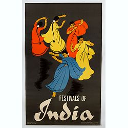
Festivals of India.
A large eye-catching poster of five women, dancing against a black background, dressed in stunning sari's of red, yellow and blue, produced in India by the Government, wi...
- $750 / ≈ €639
Date: Calcutta, 1959

Inde.
Decorative poster advertising flights to India made by Georges Mathieu. The poster is one of a series of 15 composed of posters of Greece, Israel, Germany, Great Britain,...
Date: Paris, 1967
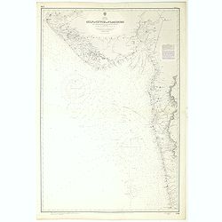
India west coast Gulf of Cutch to Vijaydurg . . .
Chart of India's west coast map surveyed by the hydrographer Captain JF Parry. A highly corrected version of Admiralty chart 2736 originally published 1st July 1915. Date...
- $200 / ≈ €170
Date: London, 1915-1980

