Browse Listings in Asia > Holy Land & Jerusalem

99 listings found. Showing results 81 to 99
Terrae Yemen Maxima Pars, seu Imperii Imami, Principatus Kaukeban nec non ditionum Haschid u Bekil, Nehhm, Chaulan, Abu Arisch et Aden Tabula ...

South-west Arabia, with the Saudi Arabian city of Jizan south to Aden. With a fine title, cartouche. Based on a map by Carsten Niebuhr. With the name Sinus Arabicus Mare ...

$700 / ≈ €655
Maker / Publisher: LOTTER, T. C.
Place & Date: Augsbourg, 1774


Terra Sancta vocata quae olim XII tribus . . .

Miniature map of the Holy Land, among the 12 Tribes and divided into 6 provinces. In the upper left near the title cartouche Pharaoh''s daughter discovers Moses in the Ri...

$300 / ≈ €281
Maker / Publisher: SEUTTER, M.
Place & Date: Augsburg, J.M.Will, 1778


Turchia Nell' Asia antica, e moderna.

Rare map of Armenia, Palestine, Turkey and northern Arabia, from "Atlante Novissimo ad uso Dei Giovani Studiosi Contenuto In Carte XXVII.", published by Giovann...

$200 / ≈ €187
Maker / Publisher: ZEMPEL, G.
Place & Date: Rome, 1780


L'Euphrate et Le Tigre.

A detailed map prepared by D'Anville. Covering the Syrian Desert, Lebanon, and the mouth of the Tigris in the Persian Gulf. Including Babylon, Tripoli, etc.

$150 / ≈ €140
Maker / Publisher: WEIGEL / SCHNEIDER
Place & Date: Nuremberg, 1783


Carte des Douze Tribus d'Israel. . .

Attractive map centered on Israel, ornated with a large decorative title cartouche. Boundaries outlined in hand color.From theAtlas moderne ou collection de cartes sur to...

$150 / ≈ €140
Maker / Publisher: LATTRÉ / BONNE, R.
Place & Date: Paris, ca 1783


Terrae Sanctae Tabula e Scripturae Sacrae, Flavii Josephi, Eusebii et Divi Hieronymi . . . Delineata.

A very fine map centered on Palestine on both sides of the Jordan, divided among the Tribes and according to the division into provinces of the Roman time.Very nice title...

$600 / ≈ €561
Maker / Publisher: LATTRÉ / DE L'ISLE, J.N.
Place & Date: Paris/ Bordeaux, 1771-1783


Carte générale pour servir à l'Intelligence de..

Fine map of the Middle East, including the Holy Land, Cyprus, Iran and Irak, etc.Philippe Buache was one of the most active proponents of the so-called, "school of t...

$300 / ≈ €281
Maker / Publisher: BUACHE, P. / DEZAUCHE
Place & Date: Paris, 1783


Terre de Chanaan, ou Terre promise à Abraham et à sa Posterité . . . .

Two maps on one sheet. With a map of Palestine and a map of the Near Eas with a title cartouche "Carte des voiages d'Abraham faits par l'ordre de Dieu, en Asie et en...

$150 / ≈ €140
Maker / Publisher: DE VAUGONDY, R. / DELAMARCHE, C.F.
Place & Date: Paris, ca. 1797


Carte des Régions et des Lieux dont il est parlé dans le Nouveau Testament.

Map of the eastern part of the Mediterranean with its hinterland. In the lower corners two inset maps: a plan of Jerusalem in the lower left, a map of Judea or Palestine ...

$50 / ≈ €47
Maker / Publisher: DELAPORTE, L'Abbé.
Place & Date: Paris, Prudhomme, Levrault, Debray, 1806


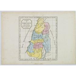
Judée ou Terre Sainte sous les Turcs.

Map of the Holy Land. By C. F. Delamarche, successor of Robert de Vaugondy, Geographer.

$50 / ≈ €47
Maker / Publisher: DELAMARCHE, C.F.
Place & Date: Paris, ca.1806


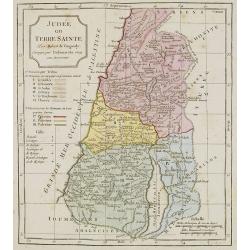
Judée ou Terre Sainte.

Map of the Holy Land, Judea. By C. F. Delamarche, successor of Robert de Vaugondy, Geographer.

$75 / ≈ €70
Maker / Publisher: VAUGONDY, R. de / DELAMARCHE.
Place & Date: Paris, 1794 -1806
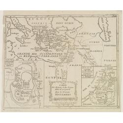
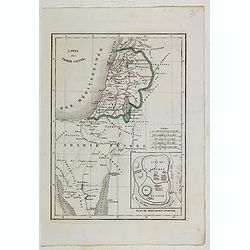


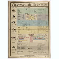
Histoire Sainte, 1840, Cours encyclopédiques - 28e Année - Méthode de Mr Colart . . .

Fine genealogic sheet for educational purpose, about Jewish history. From Adam to Cyrus. In top a map of "Palestine ou Terre Promise en 12 Tribes" 135 x 70mm.

$350 / ≈ €328
Maker / Publisher: INSTITUTEUR DES ENFANTS DE France
Place & Date: Paris, 1840


Carte de la Terre Sainte.

Detailed map of Israel, prepared by Charles V. Monin (fl.1830-1880) a French cartographer of Caen and Paris. Published in Atlas Universel de Géographie Ancienne &c M...

$25 / ≈ €23
Maker / Publisher: MONIN, C.V.
Place & Date: Paris, 1845


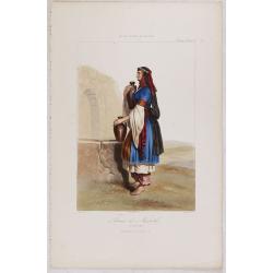
FEMME DE NAZARETH (Palestine). Costumes Syriens 10.

A beautiful hand colored lithograph of a woman from Nazareth (Palestine) published in the French work "Galerie Royale de Costumes peints d´après nature par divers ...

$300 / ≈ €281
Maker / Publisher: GALERIE ROYALE DE COSTUME.
Place & Date: Paris, Chez Aubert & Cie., 1842-1848
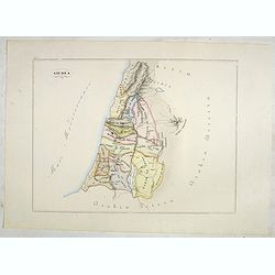


Giudea (Tav I)

A large-format map of the Holy Land with its dioceses. The map is finely engraved and beautifully colored and was prepared by Girolamo Petri, a lawyer who served as a sen...

$600 / ≈ €561
Maker / Publisher: PETRI Girolamo
Place & Date: Rome, 1858


[Map of Palestine].

Alexey Afinogenovich Ilyin was a lieutenant general and cartographer (1832-1889). In 1856, after graduating from the Academy of the General Staff, he was at the military ...

$100 / ≈ €94
Maker / Publisher: ILYIN, A.
Place & Date: St. Petersburg, 1899


Kaart van Palestina voor oud- en nieuw testament behorend bij de weg met en naar Christus door Fr. M. Bellarminus.

Original vintage illustrated map wall map sized poster (166 x 118cm) of Palestine in the time of Christ featuring a map of the old and new testament of the Bible from The...

$500 / ≈ €468
Maker / Publisher: VAN ZEIJST, A. M. E.
Place & Date: Utrecht, Sint Gregoriushuis, 1948


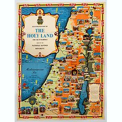
Ilustrated Map of The Holy Land for use in schools…

A visually striking and impressive pictorial map of The Holy Land, as issued by the National Savings Movement / Committee during the 1950s. In the upper left quadrant of...

$250 / ≈ €234
Maker / Publisher: NATIONAL SAVINGS COMMITTEE.
Place & Date: London, ca. 1950


Israel.

Decorative poster advertising flights to Israel made by Georges Mathieu. The poster is one of a series of 15 composed of posters of Greece, Israel, Germany, Great Britai...

$450 / ≈ €421
Maker / Publisher: MATHIEU, G. / AIR France
Place & Date: Paris, 1967