
Femina indica Orientalis - Indus Africanus - Singava vulgo dicta sive erratica femina Ori.
Beautiful engraving by Abraham de Bruyn showing inhabitants of Asian and African people with captions in Latin, French and German.Abraham de Bruyn, a Flemish engraver and...
Date: Cologne, c.1577
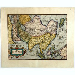
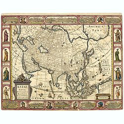
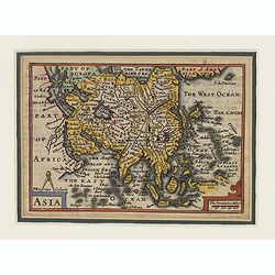
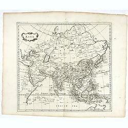
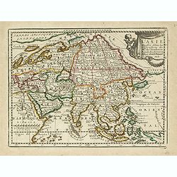
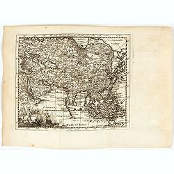
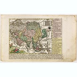
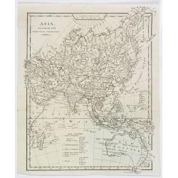
Asiae nova descriptio.
Ortelius' fine map of Asia well represents the continent at a time when Europeans were expanding their power in the Far East. The Indian subcontinent and Malaysian penins...
- $2250 / ≈ €1977
Date: Antwerp, 1603
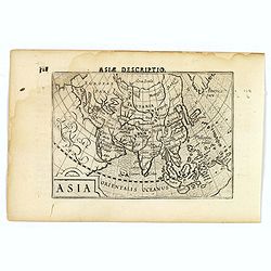
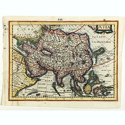
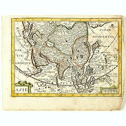
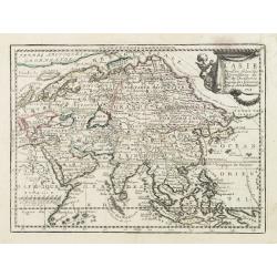
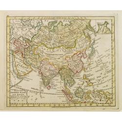
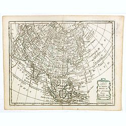
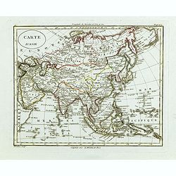
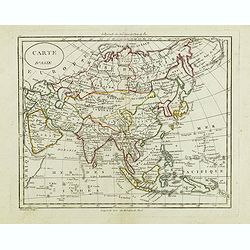
Asia.
A miniature map of the continent of Asia, published by Petrus Bertius in Amsterdam, at the beginning of the seventeenth century. An attractive small map featuring hatchin...
- $250 / ≈ €220
Date: Amsterdam, 1606
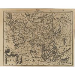
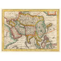
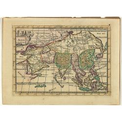
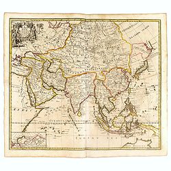
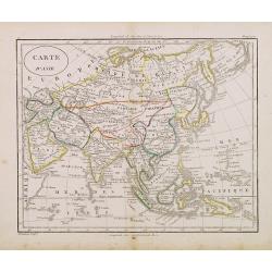
Asia.
Map of Asia with an oversized Korea and a curious shape for Japan, from the first French-text edition of Jodocus Hondius' Atlas Minor.Shortly after the publication of the...
Date: Amsterdam, 1608
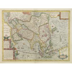
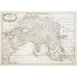
Asiae Nova Descriptio. . .
Several sources appear to have been used in the compilation of this map, including the Portuguese Jesuits Luis Teixeira (1595) for Japan, and Luis Jorgede Barbuda (1584) ...
- $3000 / ≈ €2637
Date: Amsterdam, 1613
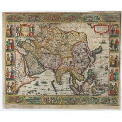
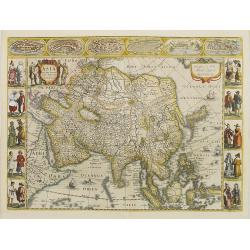
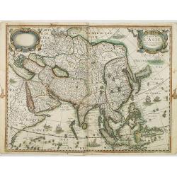
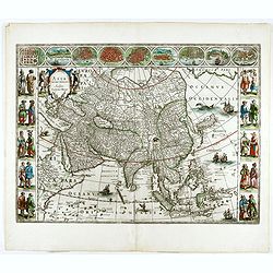
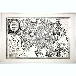
Asia recens summa cura delineata.
This is the rare early issue with decorative paneled borders of four sides. It is surrounded by elaborate borders incorporating twelve bird's eye views of cities and ten...
Date: Amsterdam, H.Hondius,1623
Asia.
Asia map from the rare Cloppenburg edition slightly larger format and more scarce edition of the Mercator/Hondius "Atlas Minor". Engraved by Pieter Van Den Keer...
Date: Amsterdam, 1630
Asia.
Early map of Asia, including Korea as in peninsular.
Date: Amsterdam, 1632
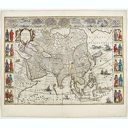
Asia recens summa cura delineata.
This is the rare early issue with decorative paneled borders. In upper border views and plans of Famagusta, Rhodos, Damascus, Jerusalem, Aden and Ormus. Originally engrav...
Date: Amsterdam, 1632

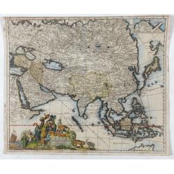
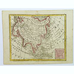
Asia secunda pars in forma Pegasi.
UNRECORDED PLATE or STATE. Asia depicted as the flying horse Pegasus. Below the depiction 3 lines of engraved Latin text. Double page copper engraved map from Heinrich Bü...
Date: Brunswick, ca. 1635
Asiae Nova Descriptio.
Final State of Pieter Van Den Keere's Rare Map of Asia -- The first map of Asia to include decorative panels. Published by N.J.Visscher and engraved by Abraham Goos, embe...
Date: Amsterdam, 1636
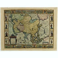
Asiae Nova Descriptio.
Final State of Pieter Van Den Keere's Rare Map of Asia--The first map of Asia to include decorative panels.The map has an interesting south positioning of the Caspian Sea...
Date: Amsterdam, 1636
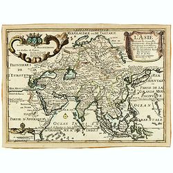
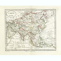
Carte de L'Asie.
Rare map of Asia with the imprint of Cornelius Danckert's in lower right corner. The cartouche in top left without text.This map was part of a set of continents printed b...
Date: Paris, 1627-1640

Asia secunda pars terrae in forma Pegasi.
Asia is depicted as the flying horse Pegasus. This cartographical curiosity, double-page copper engraved map, was published in Heinrich Bünting's “Itinerarium Sacrae Scri...
Date: Brunswick, 1640

Carte de l'Asie, corrigée et augmentée, dessus toutes les aultres Faict L année 1640.
Map of Asia with a dedication to Pierre Petit. The map bears a very close resemblance to the Asia maps of the Hondius family. Michael Van Lochom (1601-1647) was a Calvini...
Date: [Paris], 1640
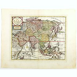
Asia noviter delineata. . .
From 1633 the members of the Blaeu family were official cartographers to the United East India Company and, as such, had access to the most up-to-date cartographic inform...
Date: Amsterdam, 1644
Asia.
This lovely rare miniature map of the continent of Asia is a single page with text on verso taken from John Speed's folio atlas, and is signed with Van den Keere's Latini...
- $275 / ≈ €242
Date: London, 1646
Asia noviter delineata..
From 1633 the members of the Blaeu family were official cartographers to the United East India Company and, as such, had access to the most up-to-date cartographic inform...
- $3500 / ≈ €3076
Date: Amsterdam, 1650
Asie.
Map of Asia still showing Corey as an island. Including America's West Coast.More about Western mapping of Korea maps. [+]
Date: Paris, 1650
Asie. (8).
Scarce map of Asia published by Antoine de Fer in 1661 or 1662 in "Cartes de géographie revues et augmentées". With number 8 in lower right bottom of the map.Th...
- $200 / ≈ €176
Date: Paris, Antoine de Fer, 1657 but 1661 or 1662
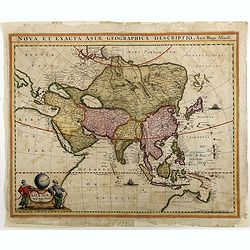
Asiae Nova Apud Hudo Allardt. / Nova et exacta Asiae geograpicha descriptio.
Rare map of Asia, with relief shown pictorially. Shows Great wall of China and the mythical island of Yedso north of Japan. Title at head of map: Nova et exacta Asiae geo...
Date: Amsterdam, 1660-1665
Asie.
Rare map of Asia, published by Jollain in 1667. The name of Korea placed in the sea in between Korea and Japan. In top right part of North America. Published in "Tré...
- $400 / ≈ €352
Date: Paris, 1667
Asie.
This rare map of Asia was published by Jollain in 1667. Published in "Trésor Des Cartes Geographiques Des Principaux Estats de Lunivers".This atlas is based upo...
Date: Paris, 1667
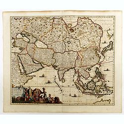
Accuratissima totius Asiae tabula..
The map includes a detailed depiction of South East Asia and the Far East. The northern tip of Australia (Hollandia Nova) is shown as are the important discoveries made t...
Date: Amsterdam, 1680
![[East coast of Africa, Arabia and west coast of India.]](/uploads/cache/04762-250x250.jpg)
[East coast of Africa, Arabia and west coast of India.]
Rare. Map of the east coast of Africa, Including Madagascar, the Arabian Peninsular, coast of Pakistan and west coast of India.Prepared by Joao Teixeira in 1649, this cha...
Date: Paris, 1664-1696
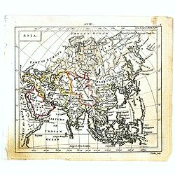
Asia.
Map of Asia. Peter Heylin or Heylyn (29 November 1599 – 8 May 1662) was an English ecclesiastic and author of many polemical, historical, political and theological tracts...
- $450 / ≈ €395
Date: London, 1703
Asia.
Uncommon map of Asia, with a curious shape for Korea. Nice title cartouche in upper left corner with an elephant and a warrior. From his atlas Oorlogs tablessen, Oft uytg...
- $300 / ≈ €264
Date: Amsterdam, 1706
Totius Asiae continens cum praecipuis insulis eidem annexis
On this map Hokkaido is connected with Honshu and even bigger depicted than Honshu. In lower left cartouche a scale and a monstrance with the sign of the Society of Jesus...
Date: Munich, 1710

Asia - L'Asie.
This print represents an allegory of Asia, one of the continents. Since ancient times, the Old World was divided into three continents: Asia, Africa and Europe. A Turkish...
- $400 / ≈ €352
Date: Augsburg, ca. 1715
L'Asie Suivant les Nouvelles Decouvertes. . .
Showing the land masses from Arabia to Japon ou I.de Niphon and Nouvelle Zeelande (but what is part of New Guinea). Decorative dedication panel and title cartouche.
- $300 / ≈ €264
Date: Paris, 1717
L' Asie Dressée Selon les Observations de Mrs. De l' Academie Royale des Sciences..
Delightful little map of Asia that conforms to the standard French model of the period. Hokkaido is attached to the mainland and Terre de Iesso is off the coast partially...
Date: Paris, 1719
L' Asie Dressée Selon les Observations de Mrs. De l' Academie Royale des Sciences..
Delightful little map of Asia that conforms to the standard French model of the period. Hokkaido is attached to the mainland and Terre de Iesso is off the coast partially...
Date: Paris, 1719
A New Map of Asia from the latest Observations Most Humbly Inscrib'd to the Right Honbl. George Earl of Warrington &c.
Fine map of Asia, with decorative title cartouche flanked by two figures in Asian dress, along with flora and fauna of the continent., based on the work of Guillaume De L...
Date: London, 1721

L'Asie suivant les nouvelles observations...
Uncommon edition of this map of Asia. From Le Nouveau Theatre du Monde, ou la Geographie Royale.The map is of interest for the use of Mer Orientale, the sea between Kore...
Date: Amsterdam, 1728
Asia Cum omnibus Imperiis, Provinciis, Statibus et Insulis. . .
A finely engraved and decorative mid-18th century map published in Augsburg, Germany and incorporating two large decorative title cartouches upper right and bottom left. ...
- $250 / ≈ €220
Date: Augsburg, 1730

Asia By H.Moll Geographer.
Detailed map of Asia. From his "Atlas minor: or a new and curious set of sixty-two maps. . .", which was first published in 1729 and reprinted in 1732, 1736.The...
Date: London, 1736
Asiae.
A very nice map of Asia. From Francisco Giustiniani for El Atlas abreviado o el nuevo compendio de la Geografia universal, politica, historica, i curiosa, segun el estado...
- $300 / ≈ €264
Date: Leon de Francia (Lyon), Jaime Certa, 1739
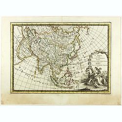
Asia Accuratissime Descripta ex omnibus, quae hactenus extiterunt, imprimis…
A rare map prepared by Nicolas Witsen (1640-1717). Witsen was cartographer, diplomat and sometime burgomaster of Amsterdam, he played a unique role in introducing Russian...
- $500 / ≈ €439
Date: Amsterdam, 1740
Nuova carta dell Asia . . .
Attractive and detailed map of Asia showing good detail in China, Mongolia, Tibet, Kamchatka, Japan, Kuriles, Korea, Manchuria, Formosa, Philippines, Indonesia Borneo, Ne...
Date: Venice, 1740

Kaartje van Asia. . .
Attractive and rare map of Asia. From Atlas Portatif . With a curious and oversized Hokkaido. The map is of interest for the use of Coreanse Zee for the sea between Korea...
Date: Deventer 1742

Kaartje van Asia. . .
Attractive and rare map of Asia. From Atlas Portatif . With a curious and oversized Hokkaido. The map is of interest for the use of Corease Zee for the sea between Korea ...
Date: Deventer, 1742

Asia secundum legitimas projectionis stereographicae.
Highlighted area covers part of Spain, eastern coast of Ireland to western part of Papua New Guinea and the Asian continent from the Northern Polar Sea to the Indian Ocea...
Date: Nurenberg, 1744
Asia.
Uncommon miniature map of Asia. The map is of interest for the use of Sea of Corea, for the sea between Korea and Japan.Engraved by J.Ellis for "A New General and Un...
- $150 / ≈ €132
Date: London, 1761-1763
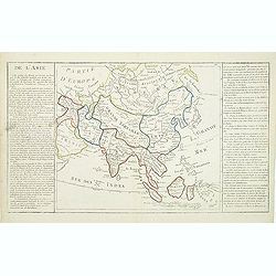
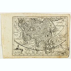
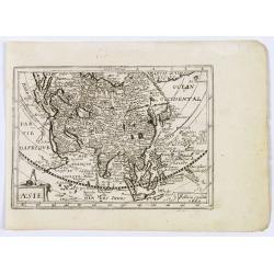
De l'Asie. . .
On the left and on the right two explication cartouche. The text is in French, interesting for its documentation of contemporary European attitudes and preconceptions reg...
Date: Paris, ca. 1767
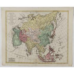
Asia secundum novas celeberrimi de l'Isle Projectiones aliorumque. . .
A pleasant map of the continent of Asia, with each country displayed in a different color. Plain oval title cartouche. A set of 5 different mileage scales lower left corn...
Date: Augsburg, 1772
A new and accurate map of Asia, Drawn from the most approved modern maps & charts / by Thos. Bowen.
The map is of interest for the use of Sea of Korea for the sea between Korea and Japan.Detailed map of Asia from Saudi Arabia, Persia, Russia, India, China, Japan to Sout...
Date: London, J.Cooke, 1777-1778

L'Asie divisée en ses principaux Etats..
A finely and crisply engraved map of Asia is decorated with an ornamental title cartouche in the lower-left corner.There are very good details of towns in modern-day Uzbe...
Date: Venice, 1776 - 1784

Carte d'Asie divisée en ses principaux Etats.
Uncommon and decorative "carte à figures" - wall map, prepared by Clouet, with superb decoration, including a wonderful rococo border with 20 decorative vignett...
Date: Paris, Mondhare, 1787
L'Asia secondo Le ultime osserviazioni divisa né suoi stati principali.
First edition on laid paper. Cassini’s splendid map depicts Asia at the end of the eighteenth century. There is good details of the region east of the Caspian Sea, showin...
- $750 / ≈ €659
Date: Rome, 1788
Asia verlegt von Ioh Mich Probst.
Uncommon map of Asia, with an explanatory text and directory on the right and the bottom of the map from the "Atlas Minor ex Tabulis Geographicis ".The map is o...
- $300 / ≈ €264
Date: Augsburg, 1789
![[Asia and part of Australia]](/uploads/cache/26453-250x250.jpg)
[Asia and part of Australia]
An engraved map of Asia shows an oversized Japan and part of Australia, called Neu Holland. To the east of the Caspian Sea, we see the area of present-day Uzbekistan and ...
- $450 / ≈ €395
Date: Tübingen, Heerbrandt, 1790
Nieuwe Generale Kaart van Asia.
Uncommon map of Asia, with Dutch text. Engraved by A.Krevelt. In the upper right-hand corner, inset the map of Siberia. The region east of the Caspian Sea, showing modern...
- $120 / ≈ €105
Date: Amsterdam, 1792

Karte von Asien.
An attractive map of Asia. With a decorative title cartouche in the upper left-hand corner. Engraved by Aarons.Franz Johann Josef von Reilly (Vienna 18 august 1766 - 6 ju...
Date: Vienna 1795
L'Asie divisée dan ses principaux états, empires, et royaumes dréssée et augmentée des plus exactes nouvelles découvertes qui ont fait en plusieurs fois les plus celebres capitaines.
A very rare map of Asia, in the style of Antonio Zatta with a scenic title cartouche, but folio-sized. It comes from a never-finished atlas by the ‘Società Calcografia’, ...
Date: Venise, 1799
Asia.
The map is of interest for the use of Gulf of Corea, the sea between Korea and Japan.William Darton, Sr. started his mapmaking business in 1787 in London, and thus began ...
- $300 / ≈ €264
Date: London, 1802
Carte d'Asie . . .
Map of the Asian continent, from Atlas moderne portatif composé de vingt-huit cartes sur toutes les parties du globe terrestre .. A l'usage des Colléges, des Pensions &am...
- $230 / ≈ €202
Date: Paris, Prudhomme, Levrault, Debray, 1806

Asia.
Uncommon map of Asia. Engraved by Marco di Pietro.The map is of interest for the use of G. di Corea, for the sea between Korea and Japan.Published by Carlo Antonio Barbie...
Date: Milan, 1807
Asia, drawn from the latest Astronomical Observations.
This finely engraved, and detailed, map of Asia shows the extent of knowledge from astronomical observations at the time. It is also of interest for showing Australia her...
Date: London ca. 1808
Carte d'Asie.
Fine map of Asia, with an interesting representations of Japan, Hokkaido, Sakhalin Island, Kamchatka and Korea. Engraved by Alexandre Blondeau, who also worked for Depôt ...
Date: Paris, c. 1810
L'Asia...
A small, uncomplicated map of Asia with outline coloring. Map extends down from the Arctic Circle to Java and New Guinea. From Arabia in the west to Japan in the east.Sma...
- $175 / ≈ €154
Date: Venezia, 1810
Carte d'Asie.
Fine map of Asia, with an interesting representation of Japan, Hokkaido, Sakhalin Island, Kamchatka, and Korea. Engraved by Alexandre Blondeau, who also worked for Depôt ...
- $175 / ≈ €154
Date: Paris, c. 1810
Carte d'Asie.
Fine map of Asia, with an interesting representations of Japan, Hokkaido, Sakhalin Island, Kamchatka and Korea. Engraved by Alexandre Blondeau, who also worked for Depot ...
Date: Paris, c. 1810
Carte d'Asie.
Fine map of Asia, with an interesting representations of Japan, Hokkaido, Sakhalin Island, Kamchatka and Korea. Engraved by Alexandre Blondeau, who also worked for Depôt ...
Date: Paris, c. 1810
Carte générale de L'asie . . .
Uncommon map of Asia prepared by Felix Delamarche, after R.de Vaugondy. In the right hand a lengthy description of geographical details of the different European countrie...
Date: Paris, 1820
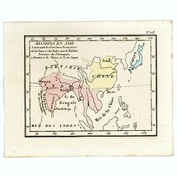
Missions en Asie Contenant les Provinces Françaises de la Chine et des Indes avec le Malabar Province des Portuguais. 7 Jésuits a la Chine et 57 au Japon.
Rare map of Far East from India until Japan from "Atlas Universel indiquant les établissemens des Jésuites: avec la manière dont ils divisent la terre, suivi desévén...
- $200 / ≈ €176
Date: Paris, Ambroise Dupont , 1826
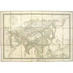
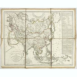
Carte physique et politique de l'Asie. Publiée pour la première fois en 1822 par J. GOUJON. Revue et augmentée par l'éditeur d'après de nouveaux matériaux.
This is a detailed map of Asie. It provides very good details of towns in modern-day Uzbekistan. The region is labeled as "Usbecs." The important cities on the...
Date: Paris, J. Goujon et J. Andriveau, 1837
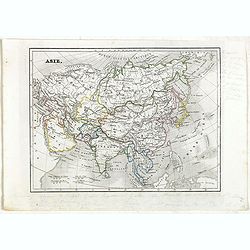
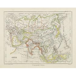
Asie.
Detailed map of Asia, prepared by Charles V. Monin (fl.1830-1880) a French cartographer of Caen and Paris. Published in Atlas Universel de Géographie Ancienne &c Mode...
- $50 / ≈ €44
Date: Paris, 1845
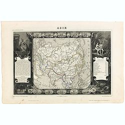
Carte de l'Asie.
Map of Asia framed by vignettes depicting costumes of the various peoples of Asia, Adam and Eve, and several exotic animals. Interesting population chart at right totalin...
Date: Paris, A. Combette, 1852
Asia.
Map of Asia encompassing the Russian Empire, the Chinese Empire, India Persia, Tartary, Turkey, and Arabia. From Sidney E. Morse''s: System of Geography for the use of sc...
Date: New York, 1855
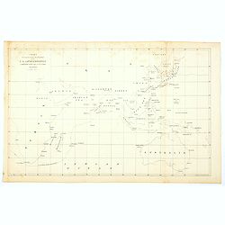
Chart showing the track of the Flagships of the US-Japan Expedition to the eastward of the Cape of Good Hope 1853 & 1854.
A simple sea chart showing the track of the US Steam Frigate Mississippi as she tracked her way from east of Cape Town across the Indian Ocean and the Bay of Bengal, up t...
- $50 / ≈ €44
Date: New York, 1857
Azie.
Uncommon map of Asia. Lithography by J.H. van Weijer, published in Atlas der geheele Aarde [...] in 24 kaarten.
Date: Groningen, ca. 1860

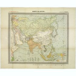
Kiepert's Physikalische Wandkarten IV. ASIEN. . .
Wall map of Asia printed in chromo lithography. Published by "Stich und Druck der lith. Anst. Von Leopold Kraatz in Berlin". Physical map showing the Asian cont...
Date: Berlin, D. Reimer, 1873

Oro-Hydrographische Kaart van Azië.
One of the earliest thematic maps of Asia published in the Netherlands from "Atlas der natuurkundige aardrijkskunde. . .". prepared by Nicolaas Wilhelmus Posthu...
- $35 / ≈ €31
Date: Amsterdam, C.L. Brinkman, 1883
![[Europe].](/uploads/cache/46154-250x250.jpg)
[Europe].
Alexey Afinogenovich Ilyin was a lieutenant general and cartographer (1832-1889). In 1856, after graduating from the Academy of the General Staff, he was at the military ...
- $100 / ≈ €88
Date: St. Petersburg, 1899
![[Asia].](/uploads/cache/46145-250x250.jpg)
[Asia].
Alexey Afinogenovich Ilyin was a lieutenant general and cartographer (1832-1889). In 1856, after graduating from the Academy of the General Staff, he was at the military ...
- $100 / ≈ €88
Date: St. Petersburg, 1899
![[South and middle Asia and the lands of the Nile.].](/uploads/cache/46144-250x250.jpg)
[South and middle Asia and the lands of the Nile.].
Alexey Afinogenovich Ilyin was a lieutenant general and cartographer (1832-1889). In 1856, after graduating from the Academy of the General Staff, he was at the military ...
- $100 / ≈ €88
Date: St. Petersburg, 1899
![[Europe].](/uploads/cache/46155-250x250.jpg)
[Europe].
A detailed map from Учебный Географический Атлас published by the very successful St. Petersburg publisher "Cartographic institution A.Ilina" ("Картографич...
Date: St. Petersburg, 1899
![[Asia].](/uploads/cache/46172-250x250.jpg)
[Asia].
A detailed map from Учебный Географический Атлас published by the very successful St. Petersburg publisher "Cartographic institution A.Ilina" ("Картографич...
Date: St. Petersburg, 1899
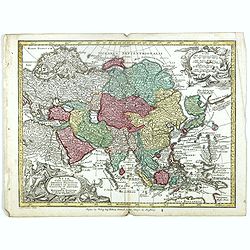
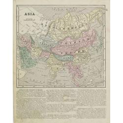
General Karte von Asien. Entworfen und gezeichnet von F. Handtke.
In upper left corner "Carl Flemmings Generalkarten No. / Nr. 37" in a 17th edition. Prepared by Friedrich Handtke (1815-1879). Scale 1: 18.886.000, with a key i...
Date: Glogau, Carl Flemming, c.1910
