Browse Listings in Asia > China > Hong Kong / Macao
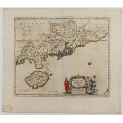
Quantung Imperii Sinarum Provincia duodecima.
A beautifully engraved map of Southern China covers Hainan, the Pearl River Delta, and Greater Hong Kong.A legend at left identifies cities and towns of various sizes, fo...
Date: Amsterdam, 1660

Quantung, e Fokien, Provincie della China...
A beautifully engraved decorative map of Southern China extending from Hainan in the West to Formosa in the East and centered on the Pearl River Delta with Macao and the ...
Date: Venice, 1691
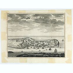
De Stad Macao.
A fine view of the city of Macao from Lappa Island showing the defenses, the forts, churches and convents: including Fort de Baare, Bon Parto, Fort St Paulo (Monte Fort)....
Date: Amsterdam, 1724
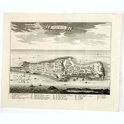
Platte Grond vande Stadt Macao.
A fine view of the city of Macao from Lappa Island showing in schematic blocks the structure of the town. With European vessels and junks in the surrounding water. With n...
Date: Amsterdam, 1724

A view of the town and castle of Macao.
A nice engraving that shows the attack of the English ship "Centurion" on Macau, during which she captured a Portuguese ship that had sailed from Manila. In upp...
Date: London, 1746
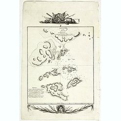
Sketch of the Typa and Macao.
A map of the environs of the Portuguese settlement of Macao in the Far East. The map shows a small town plan of Macao, nearby rocks, shoals depth soundings, and a few nav...
- $150 / ≈ €132
Date: London, 1785
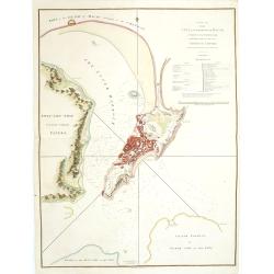
A Plan of the city and harbour of Macao : a colony of the Portugueze, situated at the southern extremity of the Chinese Empire. . .
A large chart of Macao engraved by Benjamin Baker (fl. 1766-1824) and published by George Nicol. The town of Macao is shown in detail, with a 37-point key in English list...
Date: London, 1796
![[8 sheets - Partie du THIBET]](/uploads/cache/36629-250x250.jpg)
[8 sheets - Partie du THIBET]
A set of 8 maps covering Tibet region and the Himalayas.From his famous Atlas Universel . This atlas was one of the most remarkable world atlases ever produced, anticipat...
Date: Brussels, 1825-1827
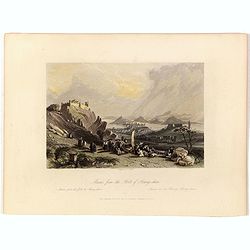
Macao from the Forts of Heang-shan.
A finely delineated view of the city of Macao as seen from one of its fortification areas. The foreground contains a group of religious worshipers. Engraved by S. Fisher....
Date: London, ca. 1840
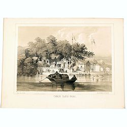
Chinese Temple, Macao.
A pleasant view of the important Chinese Temple in Macao, taken from the water with a junk in the foreground and many sampans and junks moored in front of it, with visito...
- $75 / ≈ €66
Date: Philadelphia, 1856
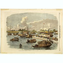
Sick and wounded embarking at Hong-Kong on Board the Steamer.
Large view of the harbour with numerous ships and people. From the Illustrated London News, October 23, 1858.
Date: London, October 1858

A fan combining views of Hong Kong (right), Canton (center), and Macau.
The fan shows nice images of Macau, Hong Kong and Canton on onside and on verso a garden with 45 characters welcoming a rider on his white horse. Their clothes are height...
Date: China, ca. 1850-1860

Plan de la rade de Macao (chine) Levé d'après les ordres mr. Rocquemaurel.
Very detailed chart of Macao and several of the surrounding Islands, and features numerous depth soundings throughout. Prepared by captain, Gaston de Rocquemaurel. Logo o...
Date: Paris, c.1856 / 1863
![Hongkong Piratenstrasse. [Pirate Street]](/uploads/cache/24363-250x250.jpg)
Hongkong Piratenstrasse. [Pirate Street]
Finely executed watercolor made by Henri Dieth of a charming street scene at "Pirate Street" in Hong Kong. The watercolor is made after Eduard Hildebrandt (1818...
Date: Germany, 1882
![Hong Kong. [Queen's Road]](/uploads/cache/24362-250x250.jpg)
Hong Kong. [Queen's Road]
Finely executed watercolor made by Henri Dieth of a charming atmospheric street scene at Queen's Road in Hong Kong. The watercolor is made after Eduard Hildebrandt (1818-...
Date: Germany, 1882
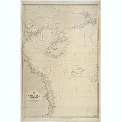
China Sea Nothern Porton compiled from the latest survey to 1884
A fine Survey chart no. 2680 showing Tong King Gulf, Hanan Island up to Hong Kong, Macao and Canto River up to Canton (Being)
- $800 / ≈ €703
Date: London, 1887, updated to 1897

COLLECTION OF HONG KONG MAPS, BOOKS & FLYERS. Including CHINA - HONGKONG surveyed by Captn. Sir Edward Belcher, in H.M.S. Sulphur 1841. Corrected to 1901.
A collection of 30 maps, prints, and publications relating to Hong Kong. Including : - BELCHER, E. Sir, An updated version of this most important nautical chart of Hong K...
Date: London, 1841 - 1901
![Wusung River or Hwang Pu. / Wusung River Entrance [With Shanhhai]](/uploads/cache/48595-250x250.jpg)
Wusung River or Hwang Pu. / Wusung River Entrance [With Shanhhai]
A fine Survey chart no. 1601 showing Wusung River or Hwang Pu. / Wusung River Entrance [With Shanghai]
- $800 / ≈ €703
Date: London, 1887 - 190, updated to 1903

CANTON Kong-Teheou.
Very detailed (1:1.000.000) map centered on Macao and Victoria Island, showing soundings, English, Australian, Danish telegraph lines reaching Hong Kong and extended to M...
Date: Paris, 1898 updated for june 1904
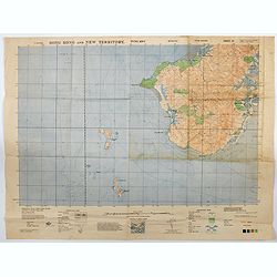
Hong Kong and New Territory - Tung Kwu.
A third edition air survey map of this portion of Lantau Island, to the west of Hong Kong, performed by the RAF. Originally published in 1931, then with minor corrections...
- $300 / ≈ €264
Date: London, 1945
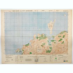
Hong Kong and New Territory - Tai O.
A third edition air survey map of this mainland portion of north west Hong Kong and New Territory, performed by the RAF. Originally published in 1931, then with minor cor...
- $400 / ≈ €352
Date: London, 1945

Key Map of Hong Kong Relative to Canton and Macao.
A nice folded map of Hong Kong and the surrounding areas. Produced by the British Crown Lands Survey Office just after WWII. Physical features are shown by contour. Railw...
Date: Hong Kong, 1948
