Search Listings matching "blaeu" in Asia
Malabar.
Small map illustrating the southwestern sea coast of India. Oriented with East on top, surrounded by text in Dutch.Included in the rare book : Wereld Spiegel, waer in ver...
- $200 / ≈ €172
Date: Amsterdam, Cloppenburch, 1621
![Narsinga. [India]](/uploads/cache/38123-250x250.jpg)
Narsinga. [India]
Small map illustrating the Indian peninsular. Oriented with East on top, surrounded by text in Dutch.Nicolaes de Clerck (de Klerc) was active as engraver and publisher in...
Date: Amsterdam, Cloppenburch, 1621
Bengala.
Small map centered on the Bay of Bengal, surrounded by text in Dutch. Nicolaes de Clerck (de Klerc) was active as engraver and publisher in Delft from 1599-1621.Included ...
- $150 / ≈ €129
Date: Amsterdam, Cloppenburch, 1621
Malabar.
Small map illustrating the south western seacoast of India. Oriented with East on top, surrounded by text in Dutch.Nicolaes de Clerck (de Klerc) was active as engraver an...
Date: Amsterdam, Cloppenburch, 1621
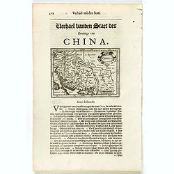
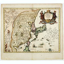
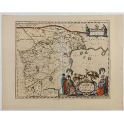
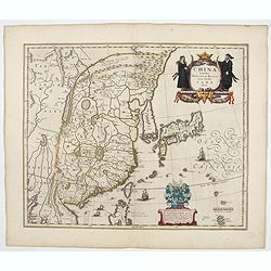
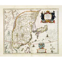
China.
Small map illustrating China with the Great Wall and Korea as an island, surrounded by text in Dutch.Nicolaes de Clerck (de Klerc) was active as engraver and publisher in...
- $200 / ≈ €172
Date: Amsterdam, Cloppenburch, 1621
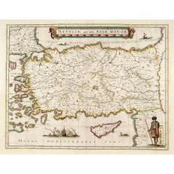
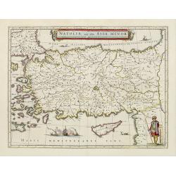
Natolia, quae olim Asia minor.
A finely designed map of Turkey and Cyprus from the great Blaeu family of Amsterdam. The decoration consist of a colored title cartouche, sea monsters, a naval engagement...
Date: Amsterdam, 1635
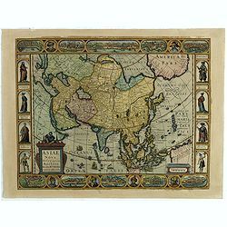
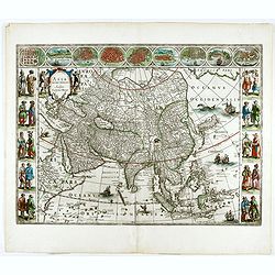
Asiae Nova Descriptio.
Final State of Pieter Van Den Keere's Rare Map of Asia--The first map of Asia to include decorative panels.The map has an interesting south positioning of the Caspian Sea...
Date: Amsterdam, 1636
China Veteribus Sinarum Regio nunc Incolis Tame dicta.
Fine map of China, based on the first of Blaeu's maps of China. In the west by the Great Wall is shown, among Taiwan is named Pakan al I. Formosa, although Tayoan is name...
- $950 / ≈ €818
Date: Frankfurt am Main, 1638
Tartaria sive Magni Chami imperium.
Detailed and decorative map of Tartary and Northern part of China. Northern tip of Korea included. The Chinese Great Wall is depicted, with Central Asia, extending from M...
- $500 / ≈ €431
Date: Amsterdam, 1638
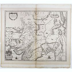
Pecheli sive Peking imperii sinarum provincia prima.
The map of the province of Peking from Joan Blaeu's Novus Atlas Sinensis , the first atlas of China with maps by the hand of the Italian Jesuit Martino Martini. A beautif...
Date: Amsterdam, 1640
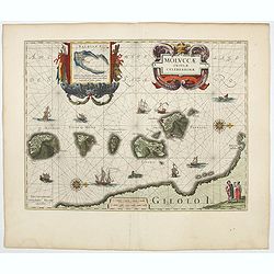
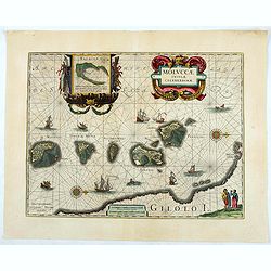
Moluccae Insulae Celeberrimae.
Showing the geographical features of the islands, and decorated with ships, sea monsters and a handsome cartouche. With an inset of Bachian island. From early on Willem ...
- $750 / ≈ €646
Date: Amsterdam, 1644
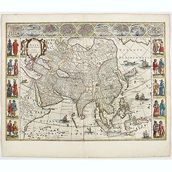
Asia noviter delineata. . .
From 1633 the members of the Blaeu family were official cartographers to the United East India Company and, as such, had access to the most up-to-date cartographic inform...
Date: Amsterdam, 1644
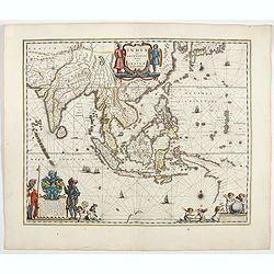
India quae Orientalis dicitur, et insulae adiacentes.
Extending from India to Japan and showing parts of Australia. It is indeed one of the first printed maps to show identifiable parts of Australia. It was not revised until...
Date: Amsterdam, 1644
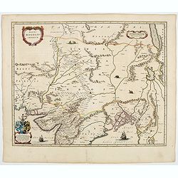
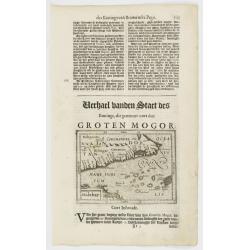
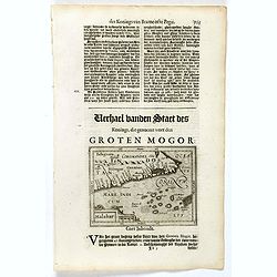
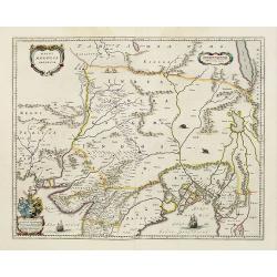
Magni Mogolis Imperium.
An attractive map of the region from Iran through Afghanistan, Tibet, and northern India across to Burma. The travel route from Kabul to Surat is the most prominent featu...
- $350 / ≈ €301
Date: Amsterdam, 1644
China Veteribus Sinarum Regio.
This was the first of Blaeu's maps of China. In 1655 he was to publish the famous map of Father Martini, with many of the earlier inaccuracies present on this map correct...
- $2200 / ≈ €1895
Date: Amsterdam, 1644
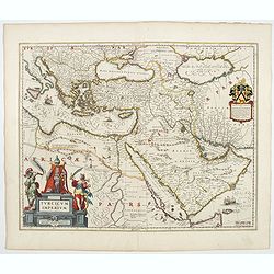
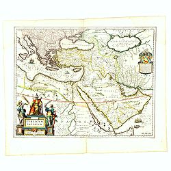
Turcicum Imperium.
A very handsome map with a particularly fine cartouche showing the Turkish Sultan on his throne and allegorical figures at either side brandishing weapons. At the right i...
- $1800 / ≈ €1550
Date: Amsterdam, 1644
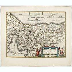
TERRA SANCTA quae in Sacris Terra Promissionis...
The Holy Land, Promised Land or Palestine. Oriented to the west. Shows the entire Palestine on both sides of the Jordan, the shore line running from Tripoli as far as the...
- $1000 / ≈ €861
Date: Amsterdam, 1644
Moluccae Insulae Celeberrimae.
Showing the geographical features of the islands and decorated with ships, sea monsters and a handsome cartouche. With an inset of Bachian island. From early on Willem J...
- $750 / ≈ €646
Date: Amsterdam, ca.1645
Magni Mogolis Imperium.
Important map of India, based upon William Baffin's map of India, first published in about 1619. The map is bounded by Pakistan, Afghanistan and Bangladesh and extends in...
Date: Amsterdam, 1650
Asia noviter delineata..
From 1633 the members of the Blaeu family were official cartographers to the United East India Company and, as such, had access to the most up-to-date cartographic inform...
- $3500 / ≈ €3014
Date: Amsterdam, 1650
China Veteribus Sinarum Regio.
This was the first of Blaeu's maps of China. In 1655 he was to publish the famous map of Father Martini, with many of the earlier inaccuracies present on this map correct...
Date: Amsterdam, 1653
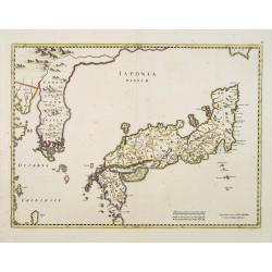
Japonia Regnum.
The first map to correctly show Korea as a peninsula. This was to remain the standard form of Japan until the eighteenth century and although replaced by the maps of Rela...
Date: Amsterdam, 1655
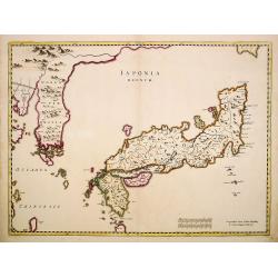
Japonia Regnum.
It is the first map to correctly show Korea as a peninsula.This was to remain the standard form of Japan until the eighteenth century and although replaced by the maps of...
Date: Amsterdam, 1655
Turcicum Imperium.
A very handsome map with a particularly fine cartouche showing the Turkish Sultan on his throne and allegorical figures at either side brandishing weapons. At right is a ...
- $1500 / ≈ €1292
Date: Amsterdam, 1658
Natolia, quae olim Asia minor.
A finely designed map of Turkey and Cyprus from the great Blaeu family of Amsterdam. The decoration consist of a colored title cartouche, sea monsters, a naval engagement...
- $450 / ≈ €388
Date: Amsterdam, 1658
Magni Mogolis Imperium.
An attractive map of the northern part of India, Tibet, Iran to Burma. The travel route from Kabul to Surat is the most prominent feature of the map. Richly decorated wit...
- $650 / ≈ €560
Date: Amsterdam, 1658

Xantung, sinarum imperii provincia quatra.
A map of the northern province ‘Xantung’ of China after the Jesuit Martino Martini.Shows the Great Wall and is centered on the Bohai Sea, and the Shandong and Liaonin...
Date: Amsterdam, ca 1660

Xantung, sinarum imperii provincia quatra.
A map of the northern province ‘Xantung’ of China after the Jesuit Martino Martini. Shows the Great Wall and is centered on the Bohai Sea, and the Shandong and Liaon...
Date: Amsterdam, ca 1660

Arabia.
A handsome map of the Arabian Peninsula drawn on a large scale on which the three classical divisions are shown with some urban centers and topographical features. A cert...
Date: Amsterdam, 1662
Xantung, e Peking provincie della china. . .
A beautiful map depicting the area of Beijing with decorative title cartouche and scale cartouche. Information about the area at the top of the map.To the right the west ...
- $350 / ≈ €301
Date: Venice, 1698

Huquang, Kiangsi, Chekiang ac Fokien.
A reissue of Janssonius' map of south east China, with wash color and uncolored cartouches.The map is based on the maps of Martin Martini, themselves based on Chinese sou...
Date: Amsterdam, 1720

Japonia Regnum.
It is the first map to correctly show Korea as a peninsula. The rare Covens and Mortier issue of this important map of Japan and Korea, originally published by Blaeu. Thi...
Date: Amsterdam, 1655 - 1720

Insularum Moluccarum Nova description.
Exquisite map of the famous Spice Islands based. This map was the first large-scale map of the region and depicts the islands which provided first the Portuguese and then...
Date: Amsterdam, 1730

Nouvel atlas de la Chine, de la Tartarie chinoise, et du Thibet.
First edition of "the principal cartographic authority on China during the 18th century". It was the second major atlas of China produced in Europe following th...
Date: The Hague, H. Scheurleer, 1737
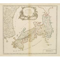
L'Empire du Japon..
Very similar to Joan Blaeu's map of 100 years previously: Europeans by then had been expelled, except the Dutch, whose movements were so curtailed that they were not able...
Date: Paris, 1756
