Browse Listings in America > North America > North America
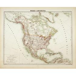
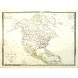
Nord-America
Large and detailed map of North and Central America. With inset key to the different possessions, Republic of Mexico, - Central America, States and territories.Lithograph...
- $150 / ≈ €128
Date: Berlin, 1872
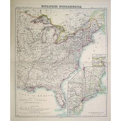
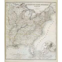
Östliches Nordamerica. . .
An extensive and detailed map of North America. With inset map lower right of "Die Nordöstlichen Staten". With color key in lower left.The map is prepared by H...
- $200 / ≈ €171
Date: Weimar 1874
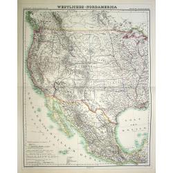
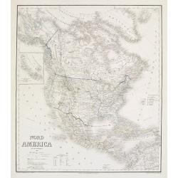
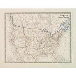
Westliches-Nordamerica.
An extensive and detailed map of North America. With color key in lower left. The map is prepared by H. Kiepert and published in Berlin by Dietrich Reimer and engraved b...
- $200 / ≈ €171
Date: Weimar, 1874
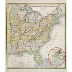
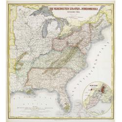
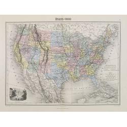
Die Vereinigten Staten von Nordamerika (Ostlicher theil).
Detailed map of eastern part of the United states. In lower right hand corner inset map of New York Bay, including, NY, Newark, Staten Island.The map is prepared by C.Gr�...
- $450 / ≈ €385
Date: Weimar, 1874
Die Vereinigten Staten von Nordamerika (Ostlicher theil).
Detailed map of eastern part of the United states until the border of Texas. In lower right hand corner inset map of New York Bay, including, NY, Newark, Staten Island.Th...
- $450 / ≈ €385
Date: Weimar, 1874
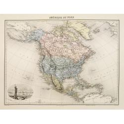
Amérique du Nord.
Decorative map of Northern America from Géographie Universelle, Atlas Migeon. published by J. Migeon. Nice engraving at the lower left hand of New York with the Statue o...
Date: Paris, 1874
Die Vereinigten Staten von Nordamerika nebst Canada.
Large and very detailed German map issued before the outbreak of the Civil War. It covers the United States, parts of Canada, and Mexico. The states and territories are s...
- $400 / ≈ €342
Date: Weimar, 1874
Nord America mit Westindien.
Detailed map of North America. With a color key indicating US, English, French, Dutch, Spanish, Portuguese, Danish possessions in the region with original outline color d...
- $300 / ≈ €256
Date: Weimar, 1874
Etats-Unis.
Decorative map of the United States from Géographie Universelle, Atlas Migeon. Oklahoma is Indian Territory with Public Lands in the panhandle. With an engraving lower l...
- $75 / ≈ €64
Date: Paris, 1874
Nouvelle carte de l'Amérique Septentrionale et des iles qui en dépendent dressée par H. Brué. . .
Very large, highly detailed, and uncommon issue of the map of North and Central America (ca. 1:13,888,000) prepared by H. Brué and improved by A.Vuillemin. Showing main ...
- $500 / ≈ €427
Date: Paris, 1875
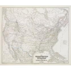
Die Vereinigten Staaten von Nordamerika (Ostlicher theil).
This is a 1876 example of C. Graf's map of the United States of America. The map covers the eastern part of the United States from eastern Texas to the Atlantic, extendin...
- $300 / ≈ €256
Date: Weimar, 1876
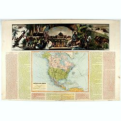
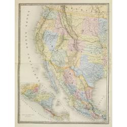
América del Norte.
Beautiful, large map of North America with a stunning panorama at the top of figures representing the continents, etc. A rare and decorative map. From "Atlas geográ...
- $550 / ≈ €470
Date: Madrid, 1877
États-Unis et Nouvelle Bretagne.
A detailed map of the United States. All different States are divided by an orange border line.
- $120 / ≈ €103
Date: Paris, 1880
Etats Unis (Etats de l' Ouest).
Large format highly detailed map of the states and territories of the West, with Central America, included in a large inset titled "Etats de l'Amerique Centrale"...
Date: Paris, 1889
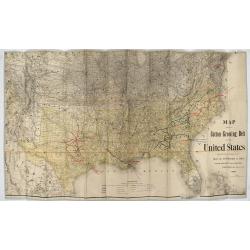
Map showing the cotton growing belt in the United States Prepared for and copyrighted by Geo. H.Mc.Fadden & Bro., cotton merchands based in Phiiladelphia, USA 1892.
The cotton-growing Belts in the Southern States for 1892 A rare map showing the cotton-growing Belts in the Southern States for 1892. Prepared for and copyrighted by G...
Date: Philadelphia, 1892
![[North America].](/uploads/cache/46142-250x250.jpg)
[North America].
Alexey Afinogenovich Ilyin was a lieutenant general and cartographer (1832-1889). In 1856, after graduating from the Academy of the General Staff, he was at the military ...
- $150 / ≈ €128
Date: St. Petersburg, 1899
![[United States map with Ottoman script.]](/uploads/cache/44314-250x250.jpg)
[United States map with Ottoman script.]
Postcard-size map in Ottoman script showing the United States, prepared by Mehmet EŞREF in a small atlas: عمومولاياةىشهانيىحاوىكوچكاطلاس [...
Date: Istanbul, 1325 or 1909
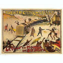
Théâtre du Châtelet. Le Tour du Monde en 80 jours. (The attack of the train).
Theatre poster for "Around the World in Eighty Days by A. Dennery and Jules Verne, for Théâtre du Châtelet, Paris. Printed by : Imprimerie Ch. Wall et Cie, 14 rue...
- $1200 / ≈ €1026
Date: Paris, Imp. Ch. Wall et Cie, ca.1900-1914

Guaranty Trust Company of New York. Emprunt national 6%.n Souscrivez.
Very decorative propaganda poster with design by Mark All of Paris for "Guaranty Trust Company of New York", a JPMorgan Chase predecessor in order to promote th...
Date: Paris, 1918

United States At-A-Glance.
A clever device for demonstrating the statistics of each state, the Area, Population, Highest Elevation, Principal River, Capital, railroad Mileage, Date Entered Union, P...
Date: New York / London: International At-A-Glance Chart Co. 1931

The Greyhound Map of This Amazing America. . .
A large colored lithograph map of the USA, published by the Greyhound Corporation during the Second World War. The map demonstrates where all the Greyhound bus routes int...
Date: United States, 1941

Alabama. Official Highway map 1942.
Folding road map of Alabama. Published in Montgomery, Alabama by Paragon Press. Mileage chart and six city plans in margin; verso includes text and photos. Scale [ca. 1:8...
Date: Alabama, Paragon Press, 1942

Coast to Coast.
A game board that features a map of the U.S. with a built-in spinner. Players travel a circular track around the map visiting landmarks as they go. A fun way to learn geo...
Date: New York, ca. 1950
![[In Arabic, translates : A map of the United States of America shows its major regional ressources and its natural products]](/uploads/cache/43010-250x250.jpg)
[In Arabic, translates : A map of the United States of America shows its major regional ressources and its natural products]
Chromolithographed pictorial poster of the United States in Arabic. Showing the United States' main products, regional resources and physical features. The map is covered...
Date: Washington D.C., ca. 1965

