Browse Listings in America > North America
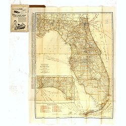
Rand Mc.Nally indexed pocket map Tourits' and Shipper' Guide of Florida. . .
This fine pocket map has on both side a map of Florida. Folding color map (approximately 640 x 495mm) is titled "Rand McNally standard map of Florida" and one h...
Place & Date: Chicago & New York, ca.1915

.Pascaerte Vande Zuyd-Zee tusschen California, en Ilhas de Ladrones. . .
A decorative and most interesting map - being one of the earliest of the Pacific to record the observations of Tasman's voyages. The northern part of the island of Califo...
Place & Date: Amsterdam, 1666
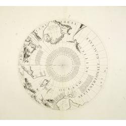
Two polar calottes from a globe.
Two polar calottes from 110 centimeters in diameter globe of 1688 including the northern part of Baffin Bay, Greenland, Iceland, Nova Zembla. Coronelli elected to follow ...
Place & Date: Venice, 1696
![A Map of the United States and Canada, New-Scotland, New-Brunswick and New-Foundland ... [together with] A Map of the West-Indies and of the Mexican-Gulph...](/uploads/cache/39235-250x250.jpg)
A Map of the United States and Canada, New-Scotland, New-Brunswick and New-Foundland ... [together with] A Map of the West-Indies and of the Mexican-Gulph...
A Map of the United States and Canada, New-Scotland, New-Brunswick and New-Foundland / Carte des Etats Unis, avec Le Canada, la Nouvelle Ecosse, le Nouveau Brunswick &...
Place & Date: Paris, 1806

Polus Arcticus cum vicinis regionibus.
Map of the North Pole regions from the 1608 second edition of Jodocus Hondius' Atlas Minor.A reduction of the 1606 Mercator-Hondius folio map (which is a later state of t...
Place & Date: Amsterdam, 1608
Selling price: $500
Sold in 2012
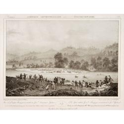
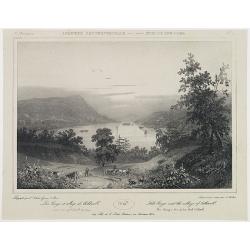
The spot where General Burgoyne surrendered to General Gates.
Decorative print after Jacques Milbert, and lithographed by Sabatier and the figures by Victor Adam.From Amérique Septentrionale. Printed by de Bove and Noöl ainé &...
Place & Date: Paris, 1829

Bison Iubatus.
Etching of a bison by Leendert Brasser (1727 - 1793) after a painting of the Dutch artist Gerrit van den Heuvel.An early portrait of a bison, etched by Leendert Brasser (...
Place & Date: Rotterdam, 1766-1793
![Noweav Mexiqve [California as an Island]](/uploads/cache/03796-250x250.jpg)
Noweav Mexiqve [California as an Island]
Uncommon miniature map of California as a island, from Pierre Duval's La Geographie Universeille in a second state. The map is derived from Audience de Guadalajara (1657)...
Place & Date: Paris, 1663
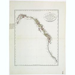
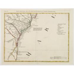
Carte de la partie de la cote nord-ouest de l'Amerique. Reconnue pendant les Etes de 1792, 1793 et 1794 depuis 29054' de latitude nord et 244033' de. . .
Detailed and rare map of the Gulf of Alaska, British Columbia, south to St.Francisco.Prepared by Edward Roberts after information by George Vancouver. Engraved by Tardieu...
Place & Date: Paris, 1820
Selling price: $150
Sold in 2011

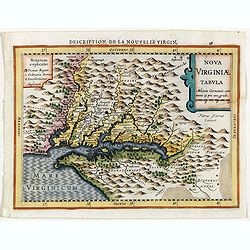
Nova Virginiae tabula.
A fine example of Blaeu's map of Virginia and the Chesapeake region is based on the first state of Smith's map, 1612, and is slightly larger and more expertly engraved.Th...
Place & Date: Amsterdam, 1635/1660
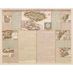
Carte qui contient..Iles & Terres..L'Amerique..Jamaique..
Eight maps on one sheet. From Chatelain's Atlas Historique et Méthodique . Including maps of Bermuda, Jamaica, New England with Long Island, Carolina, Chesapeake and Del...
Place & Date: Amsterdam, 1728
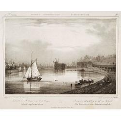
Pierpont's distillery on Long Island.
Decorative print after Jacques Milbert, and lithographed by Sabatier and the figures by Victor Adam.From Amérique Septentrionale. Printed by E.Ardit, Rue Vivienne, Paris...
Place & Date: Paris, 1829

Carte des Possessions Françoises et Angloises dans le Canada, et partie de la Louisiane.
First state of this separately published map of the European Colonies in the New World east of the Mississippi River. This map was published in 1756 to provide informatio...
Place & Date: Paris, 1756

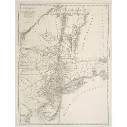
Connecticut and Parts adjacent at Amsterdam. .
A nice example of this early map of the state of Connecticut with part of Rhode Island to the east, Long Island to the south, and New York to the east. Rivers, roads, t...
- $30000 / ≈ €28072
Place & Date: Amsterdam, 1780

Avantures du Sr. C. Le Beau, avocat en parlement ou Voyage curieux et nouveau parmi les Sauvages de l'Amérique Septentrionale. Dans lequel on trouvera une Description du Canada… Ouvrage enrichi d'une Carte et des figures necessaires.
A description of Huron, Iroquois, and Algonquin customs, written in charming style and based, the Author claims, on observations made on a trip to America in 1729." ...
- $2500 / ≈ €2339
Place & Date: Amsterdam, 1738

Alabama. Official Highway map 1942.
Folding road map of Alabama. Published in Montgomery, Alabama by Paragon Press. Mileage chart and six city plans in margin; verso includes text and photos. Scale [ca. 1:8...
- $100 / ≈ €94
Place & Date: Alabama, Paragon Press, 1942
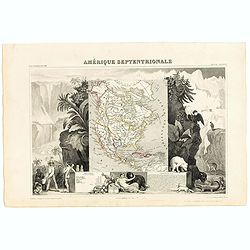
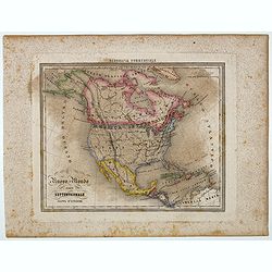
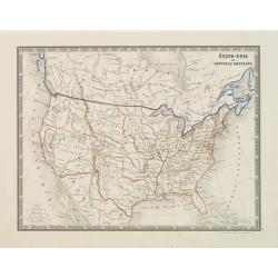
Amerique Septentrionale.
Beautiful map with the United States extending into present day Canada, Russia in control of Alaska and Mexico's northern border according to the Treaty of 1810. Surround...
- $175 / ≈ €164
Place & Date: Paris, A. Combette, 1852
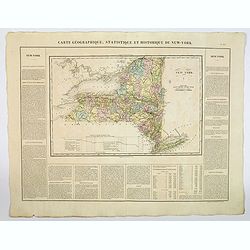
Carte Geographique, Statistique et Historique du New York.
A detailed map of State of New York, from Buchon's Atlas Gégraphique Statistique, historique et chronologique des deux Ameriques et des isles adjacentes, traduit de l'at...
- $100 / ≈ €94
Place & Date: Paris, 1825
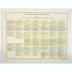
Carte Chronologiquedes Etats-Unis.
A hand colored historical timeline table (in French), highlighting "the main [historical] events in the years from their establishment to the declaration of independ...
- $100 / ≈ €94
Place & Date: Paris, 1825
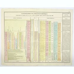
Pantographie de l'Histoire d'Amerique, ou Description de la situation relative des etats et colonies de l'Amerique. . .
An attractivelooking hand colored historical timeline table (in French), charting important historical events and discoveries of America and their States and Colonies sin...
- $100 / ≈ €94
Place & Date: Paris, 1825
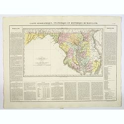
Carte Geographique, Statistique ey Historique du Maryland.
A lovely, detailed map of Maryland, from Buchon's, Atlas Gégraphique Statistique, historique et chronologique des deux Ameriques et des isles adjacentes, traduit de l'at...
- $100 / ≈ €94
Place & Date: Paris, 1825
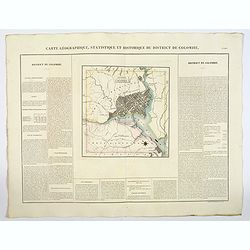
Carte Geographique, Statistique ey Historique du District de Colombie.
A lovely, detailed map of the District of Columbia, (Washington) from Buchon's, Atlas Gégraphique Statistique, historique et chronologique des deux Ameriques et des isle...
- $100 / ≈ €94
Place & Date: Paris, 1825
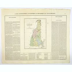
Carte Geographique, Statistique et Historique du New Hampshire.
A detailed map of New Hampshire, from Buchon's Atlas Gégraphique Statistique, historique et chronologique des deux Ameriques et des isles adjacentes, traduit de l'atlas ...
Place & Date: Paris, 1825
Selling price: $50
Sold in 2019
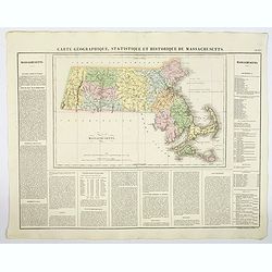
Carte Geographique, Statistique et Historique de Massachusetts.
A detailed map of Massachusetts, from Buchon's Atlas Gégraphique Statistique, historique et chronologique des deux Ameriques et des isles adjacentes, traduit de l'atlas ...
- $100 / ≈ €94
Place & Date: Paris, 1825
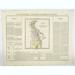
Carte Geographique, Statistique et Historique du Delaware.
A nice detailed map of Delaware, from Buchon's Atlas Gégraphique Statistique, historique et chronologique des deux Ameriques et des isles adjacentes, traduit de l'atlas ...
- $100 / ≈ €94
Place & Date: Paris, 1825
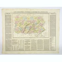
Carte Géographique, Statistique et Historique de la Pensylvanie.
A detailed map of Pennsylvania, from Buchon's Atlas Gégraphique Statistique, historique et chronologique des deux Amériques et des isles adjacentes, traduit de l'atlas ...
- $100 / ≈ €94
Place & Date: Paris, 1825
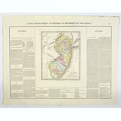
Carte Géographique, Statistique et Historique du New-Jersey.
A detailed map of New Jersey, from Buchon's Atlas Gégraphique Statistique, historique et chronologique des deux Amériques et des isles adjacentes: traduit de l'atlas ex...
Place & Date: Paris, 1825
Selling price: $50
Sold in 2019
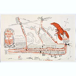
Map of Atlantic City to Hackney's Famous Garden of Sea Food . . .
A mid 1950s brochure for the famous Atlantic City Seafood Restaurant - 'Hackneys'. One side proclaims that "All Roads lead to Hackney's". It shows a nice plan o...
- $50 / ≈ €47
Place & Date: New Jersey, ca 1954
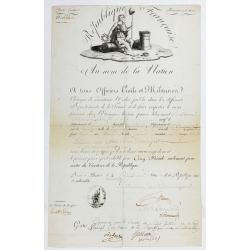
Passeport.
Passport for the United States in the name of Madeleine Lavit Femme Lory, issued by the Commission of Interior Relations and approved by the Committee of Public Safety.Th...
- $750 / ≈ €702
Place & Date: Paris, 1795
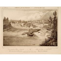
Falls of mount Ida, above the town of Troy.
Decorative print after Jacques Milbert, and lithographed by Bichbois, Showing the Water Falls of mount Ida, above the town of Troy.From Amérique Septentrionale. Printed ...
- $150 / ≈ €140
Place & Date: Paris, 1829
![Hudson Fall at the village of Gleens. . . [title in French, English, German & Latin] N°22. Pl. 2.](/uploads/cache/26656-250x250.jpg)
Hudson Fall at the village of Gleens. . . [title in French, English, German & Latin] N°22. Pl. 2.
A view of the Hudson Fall at the village of Gleens.From 6e Livraison Amérique Septentrionale - Etat de New York. After Jacques Milbert and lithographed by Tirpenne. Prin...
- $150 / ≈ €140
Place & Date: Paris, Bove dirigée par Nöel ainé & Cie, 1829
Lake George and the village of Caldwell. . . N°24.
A view of Lake George and the village of Caldwell.From 6e Livraison Amérique Septentrionale - Etat de New York. After Jacques Milbert and lithographed by L. Sabatier, th...
- $150 / ≈ €140
Place & Date: Paris, E. Ardit, 1829
![Extremity of Adley's Falls. . . [title in French, English, German & Latin] N°27. Pl. 3.](/uploads/cache/26659-250x250.jpg)
Extremity of Adley's Falls. . . [title in French, English, German & Latin] N°27. Pl. 3.
A view of the extremity of Adley's Falls..From 7e Livraison Amérique Septentrionale - Etat de New York. After Jacques Milbert and lithographed by L. Sabatier. Printed by...
- $120 / ≈ €112
Place & Date: Paris, E. Ardit, 1829
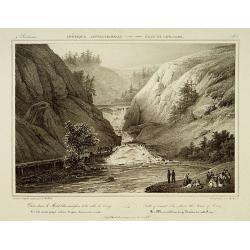
Bridge on the Hudson River near Luzerne. . . N°25. Pl. 1.
A view of a bridge on the Hudson River near Luzerne. .From 7e Livraison Amérique Septentrionale - Etat de New York. After Jacques Milbert and lithographed by Bichebois. ...
- $120 / ≈ €112
Place & Date: Paris, Henri Gaugain & Cie, 1829
General view of the Hudson at Adley's. . . N°29.
A panoramic view of the Hudson River at Adley's.From 8e Livraison Amérique Septentrionale - Etat de New York. After Jacques Milbert and lithographed by Jacottet, the fig...
- $120 / ≈ €112
Place & Date: Paris, Henri Gaugain & Cie, 1829
![[Waterfall in New York State] Pl. 2.](/uploads/cache/26821-250x250.jpg)
[Waterfall in New York State] Pl. 2.
View of a waterfall.An outstanding view most probably from Milbert's Itinéraire pittoresque du fleuve Hudson et des parties latérales de l'Amérique du Nord.Milbert arr...
- $100 / ≈ €94
Place & Date: Paris, Bove dirigée par Nöel ainé & Cie, 1829
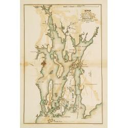
Plan of part of RHODE ISLAND..
Map showing vicinity around New Port. It Shows American and British armies at the siege of Newport and the subsequent action on the 29th of August 1778. Depicting the Fre...
- $100 / ≈ €94
Place & Date: Philadelphia, 1806 or 1834
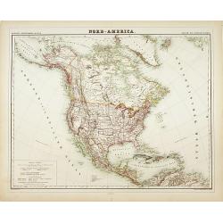
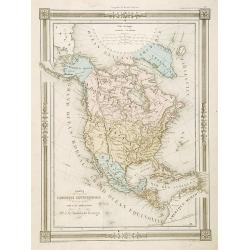
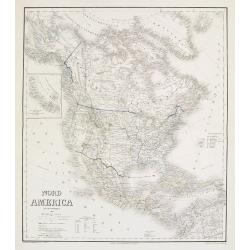
Nord-America
Large and detailed map of North and Central America. With inset key to the different possessions, Republic of Mexico, - Central America, States and territories.Lithograph...
- $150 / ≈ €140
Place & Date: Berlin, 1872

La Florida/ Peruviae Auriferae regionis Typus/ Guastecan.
The Chaves map of Florida is a prime example of an explorer's map since it records the recent discoveries of Cabeza de Vaca, De Soto, and Moscoso. The map revealed little...
- $1400 / ≈ €1310
Place & Date: Antwerp, 1592
De vereenigde staten van Noord America.
Rare miniature map of Eastern United States. The map carries the signatures of W.Holtrop and the engraver H.Klokhoff. Steven van Esveldt's business was carried on by his ...
- $450 / ≈ €421
Place & Date: Amsterdam, 1791
AMERIQUE SEPTENTRIONALE dressée sur les Relations les plus modernes des Voyageurs et Navigateurs ou se remarquent LES ETATS UNIS. . .
This large map of North America and the West Indies was originally published in 1750: however after the Treaty of Paris recognized the United States in 1783 the map was '...
Place & Date: Paris, after 1786
Selling price: $750
Sold in 2011
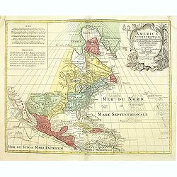
America Septentrionalis, Concinnata juxta Observationes..
This exemplar represents Lotter's version of Delisle's foundation map of North America, published in 1700. The Great Lakes show the French strong holds at Quebec, Montrea...
- $875 / ≈ €819
Place & Date: Augsburg, ca. 1770

Map of Pensylvania and New Jersey by H.S. Tanner.
First edition of this rare and important map of Pennsylvania and New Jersey by H.S. Tanner and published in his "New American Atlas" from 1823. Includes roads, ...
- $1000 / ≈ €936
Place & Date: Philadelphia, Henry Tanner, 1823
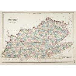
Kentucky.
A detailed lithographed map of Kentucky. Published by Adam (1784-1874) and Charles Black, publishers active in Edinburgh.
- $100 / ≈ €94
Place & Date: Edinburg, 1874

City of Boston.
A handsome mid 19th century panoramic view of the city of Boston as seen from the southern part of it's harbor. Many monuments are clearly visible, including the State Ho...
- $250 / ≈ €234
Place & Date: New York, 1872-1874
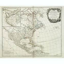
L'Amerique septentrionale, Dressée sur les memoires les plus recens. . .
A very detailed map extending from Hudsons Bay to Panama, and including the West Indies. The map is a later copy of Guillaume de L'Isle's foundation map of North America,...
- $1500 / ≈ €1404
Place & Date: Amsterdam, 1740
Östliches Nordamerica. . .
Large and detailed map of North America. With inset map lower right of ""Die Nordöstlichen Staten"". With color key in lower left.The map is prepared...
- $200 / ≈ €187
Place & Date: Weimar 1874
Carte d' Amérique Septentrionale 1817.
Map of North and Central America. Engraved by E.Collin, active at 23, quai des Augustins, Paris.
- $300 / ≈ €281
Place & Date: Paris, 1817
Carte de la Louisiane et du Cours du Mississipi Dressée sur un grand nombre de Memoires..
Covens & Mortier's issue of Delisle's influential map of the French possession of Louisiana. Updated to include New Orleans. When originally published in 1718, it was...
- $2400 / ≈ €2246
Place & Date: Amsterdam, c. 1745
![Etats-Unis de L'Amerique Septentrionale. [Two sheets in manuscript ]](/uploads/cache/03972-250x250.jpg)
Etats-Unis de L'Amerique Septentrionale. [Two sheets in manuscript ]
Two sheets giving an detailed information in French, about population in the year 1810, principal cities, products of industry and commerce, financial situation for the y...
- $2000 / ≈ €1871
Place & Date: France, ca. 1819
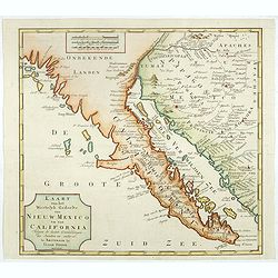
Kaart van het Westelyk Gedeelte van Nieuw Mexico en van California. . . MDCCLXV ..
A detailed map of the Baja California and Sonora, bounded on the north by the Colorado and Gila Rivers and approximately Mozatlan in the south, thus including parts of mo...
- $875 / ≈ €819
Place & Date: Amsterdam, 1765
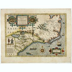
Virginiae item et Floridae. . .
Cummings describes it as one of the most beautifully executed maps ever made of the Southeast. In detail and in general conception it surpasses all earlier maps of the re...
- $2500 / ≈ €2339
Place & Date: Amsterdam, 1630
Virginiae item et Floridae . . .
Map of Virginia from the rare Cloppenburg edition slightly larger format and more scarce edition of the Mercator/Hondius "Atlas Minor". Engraved by Pieter Van D...
- $750 / ≈ €702
Place & Date: Amsterdam, 1630

System of Penal Law, prepared for the State of Louisiana , comprising codes of offenses and punishments, of procedure, of prison discipline, and of evidence applicable as well to civil as to criminal cases.
The "Enquiries" of Rush and Bradford and the Pennsylvania movement toward abolition of the death penalty had a little immediate impact on the practices of other...
- $2500 / ≈ €2339
Place & Date: New-Orleans, Benjamin Levy, 1824
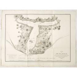
Plan du Port des Francais sur la Cote du Nord-Ouest de l'Amerique, par 58°37' de Latitude Nord et 139°50' de Longitude Occidentale, Decouverte le 2 Juillet 1786, par les Fregates Francaise la Boussole et l'Astrolabe.
Chart of the entrance of Bassin de L'Quest , visited on July 2nd 1786 by La Perouse. On many 18th century maps we find a depiction of Mer de L'Quest or Sea of the West a ...
- $500 / ≈ €468
Place & Date: Paris, 1798

Portrait de George Washington.
Portrait of the first president of the united states of America.From Giulio Ferrario's work Le Costume ancien et moderne ou histoire du gouvernement, de la milice, de la ...
- $150 / ≈ €140
Place & Date: Milan 1827
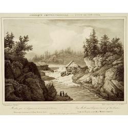
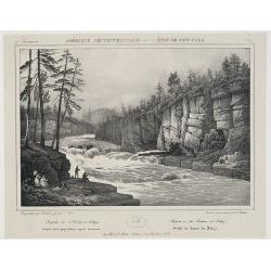
Saw Mill near Luzerne source of the Hudson.
Decorative print of Saw Mill near Lucerne, Warren County, after Jacques Milbert, and lithographed by Bichebois.Printed by de Bove and Noöl ainé &Cie. An outstanding...
- $150 / ≈ €140
Place & Date: Paris 1829
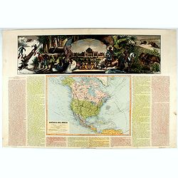
América del Norte.
Very attractive large map of North America with stunning panorama at top of figures representing the continents, etc. A rare and decorative map. From "Atlas geográf...
- $550 / ≈ €515
Place & Date: Madrid, 1877
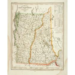
Neueste Karte von New Hampshire und Vermont.
Detailed map of New Hampshire and Vermont with numerous physical and political features including mines, settlements, trails/roads, forts and Indian areas. From Meijers H...
- $150 / ≈ €140
Place & Date: Hildburghausen/ Philadelphia, 1846
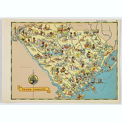
South Carolina.
A fun, humorous, whimsical map of South Carolina by Ruth Taylor White. With vibrant colors.The state is filled with delightful cartoonish characters, some pursuing assort...
- $125 / ≈ €117
Place & Date: Boston, ca 1935
Parte Orientale della Florida, della Giorgia, e Carolina. . .
Attractive map covering the coast from S.Augustine till Long Bay, including Jacksonville, Savannah. From Zatta's Atlante Novissimo.
- $350 / ≈ €328
Place & Date: Venice, 1778
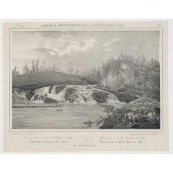
Falls of the Hudson at Sandy Hill.
Decorative print of the Falls on the river Hudson near Sandy Hill, after Jacques Milbert, and lithographed by Bichbois and the figures by Victor Adam.An outstanding view ...
- $150 / ≈ €140
Place & Date: Paris, 1829
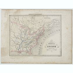
Stati Orientali della Unione Americana.
Uncommon map of Northeastern America prepared by Francesco Costantino Marmocchi. Above the map "Geografia Commerciale". From "Il Globo Atlante di carte Geo...
- $50 / ≈ €47
Place & Date: Genova, Paolo Rivara fu Giacomo, 1858

Amérique Septentrionale .. Les Etats Unis..
Very rare state: probably separately issued. Published the same year the Treaty of Paris was signed, this is one of the first maps to provide printed boundary lines for t...
- $3000 / ≈ €2807
Place & Date: Paris, 1786
Nuovo Mondo parte Settentrionale.
Uncommon map of North America prepared by Francesco Costantino Marmocchi. Above the map "Geografia Commerciale". From "Il Globo Atlante di carte Geografich...
- $50 / ≈ €47
Place & Date: Genova, Paolo Rivara fu Giacomo, 1858

Course of the Hudson and the Millsnear Sandy Hill.
Decorative print after a design of Jacques Milbert, and lithographed by Sabatier, showing the River Hudson with the falls near Sandy Hill.From Amérique Septentrionale. P...
- $150 / ≈ €140
Place & Date: Paris, 1829
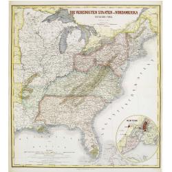
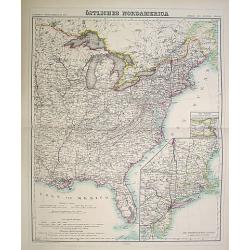
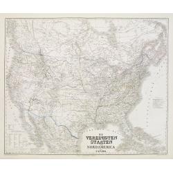
Die Vereinigten Staten von Nordamerika (Ostlicher theil).
Detailed map of eastern part of the United states until the border of Texas. In lower right hand corner inset map of New York Bay, including, NY, Newark, Staten Island.Th...
- $450 / ≈ €421
Place & Date: Weimar, 1874
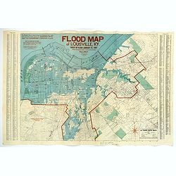
Flood Map of Louisville, KY.
A scarce poster of the great flood of Louisville, KY in 1937. The blue coloring highlights the flooded areas of the city, while the red numbers show the depth of the floo...
- $500 / ≈ €468
Place & Date: Louisville, 1938

A Hysterical Map of the Yellowstone Park. . .
A funny 1936 pictorial map of Yellowstone Park, that was 'hatched and scratched' by the American printer and humourist Jolly Elmer Lindgren. This wonderful map covers the...
- $475 / ≈ €444
Place & Date: Spokane, 1936
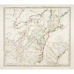
Gedeelte van den Vereenigden Staat van Noord Amerika.
A rare an detailed map of the eastern part of the United States of America. After Isaac Weld's map from his Travels through the States of North America 1799. Barbara Back...
- $650 / ≈ €608
Place & Date: Netherlands c. 1820
Die Vereinigten Staten von Nordamerika nebst Canada.
Large and very detailed German map issued prior to the outbreak of the Civil War. It covers the United States with parts of Canada and Mexico. The states and territories ...
- $400 / ≈ €374
Place & Date: Weimar, 1874
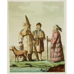
Les Aleuts.
From Giulio Ferrario's work Le Costume ancien et moderne ou histoire du gouvernement, de la milice, de la religion, des arts, etc. published in Milan by the author betwee...
- $50 / ≈ €47
Place & Date: Milan, 1827
Carte L'Amérique Septentrionale..
Detailed map of North America, prepared by J.G.Barbié du Bocage.Engraved by Ch.Smith, published by Basset who was established in Paris, rue de Seine 33.
- $100 / ≈ €94
Place & Date: Paris, 1848
États-Unis et Nouvelle Bretagne.
Detailed map of the United States. All different States are divided by an orange border line.
- $120 / ≈ €112
Place & Date: Paris, 1880

A new & accurate map of Louisiana, with part of Florida. . .
An English view of North America compiled from available French maps, especially those of Bellin used in Charlevoix's History of New France. English cartographers had lit...
- $1000 / ≈ €936
Place & Date: London, 1744
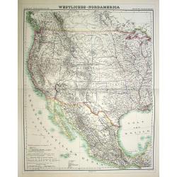
Westliches-Nordamerica.
Large and detailed map of North America. With color key in lower left.The map is prepared by H.Kiepert and published in Berlin by Dietrich Reimer. Engraved by C.L.Ohmann.
- $200 / ≈ €187
Place & Date: Weimar, 1874
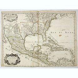
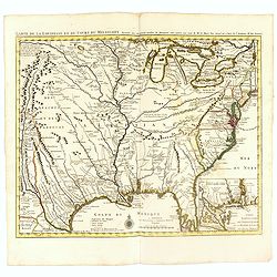
Carte du Mexique et de la Floride des Terres Angloises et des Isles Antilles...
Scarce state not listed by Tooley with the imprint : "Chez l’Auteur sur le Quai de l’Horloge a la Cour.r de Diamãs. Avec Privilege du Roy po.r 20 ans, 1703"...
- $1500 / ≈ €1404
Place & Date: Paris, 1703
Nord America mit Westindien.
Detailed map of North America. With a color key indicating US, English, French, Dutch, Spanish, Portuguese, Danish possessions in the region with original outline color d...
- $300 / ≈ €281
Place & Date: Weimar, 1874
Carte des troubles De L'Amerique Levée par Ordre du Chevalier Tryon. . . New-York.. Jersey..
A French edition of this uncommon Revolutionary War map describes the region from Salem Massachusetts to Buzzard's Bay south to the Delaware River and west to Lake Ontari...
- $1500 / ≈ €1404
Place & Date: Paris, 1778
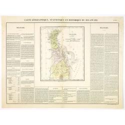
Carte Géographique .. Delaware.
Detailed map of Delaware. From J.A. Buchon, Atlas Gégraphique Statistique, historique et chronologique des deux Ameriques et des isles adjacentes, traduit de l'atlas ex�...
- $300 / ≈ €281
Place & Date: Paris, 1825