Browse Listings in Europe
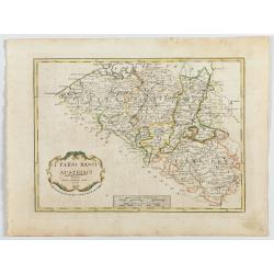
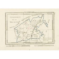
I Paési Bassi Austriaci.
A rare and detailed map of Belgium by Pazzini, Carli (1707-1769) and Bartolomeo Borghi (1750-1821). Features decorative title cartouche. Included in "Atlante Geogra...
- $125 / ≈ €108
Date: Siena, 1796
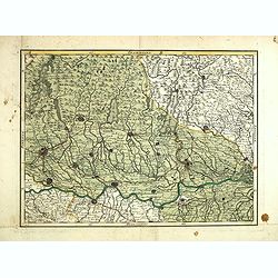
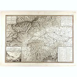
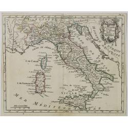
(Untitled map of northern Italy)
Including the towns of Milan, Bergamo, Mantova, Verona with the river Po in the bottom. One page from his multi sheet map "Carta del Territorio della Repubblica Casa...
- $250 / ≈ €216
Date: Florence, 1797
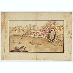
Piano di Nizza.
Rare 1797 manuscript map of Nice, with the French navy attacking from the sea. Unknown author, Italian, but map attributed to an original, probably broadsheet map by Moll...
Date: Italy, after 1797
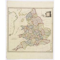
Present Britain.
A fully colored map of England and Wales from An Universal Atlas Consisting of a Complete Set of Maps, peculiarly adapted to illustrate and explain ancient and modern geo...
Date: London, 1797

Vue de Malthe du cote du Fort.
A so-called optical print of Valletta seen from the castle. This rare optical print shows people in typical French dresses in the foreground and placed in boats.In the ei...
Date: Paris, 1798
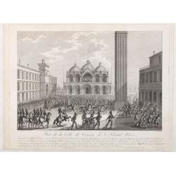
Prise de la ville de Venise le 3 floréal an 5.
Capture of the City of Venice on 3 Floréal, Year V", engraved by Pierre-Adrien Le Beau after Thomas-Charles Naudet. Deposited at the Bibliothèque nationale.During ...
Date: Paris, chez Jean, c. 1798
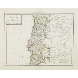
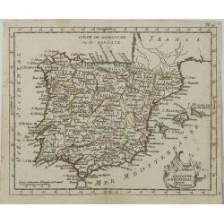
Royaume de Portugal Carte Générale.
Map of Portugal in attractive out-line color.
- $100 / ≈ €86
Date: Paris, 1799
![[Set of 6 maps] Charta öfver Storfurstendömet Finland på Friherre S. G. Hermelins Anstalt och Omkostnad. Sammandragen och författad af C. P. Hällström. Philos. Magister och Auscultant i Kongl. BergsColl. 1799.](/uploads/cache/34482-250x250.jpg)
[Set of 6 maps] Charta öfver Storfurstendömet Finland på Friherre S. G. Hermelins Anstalt och Omkostnad. Sammandragen och författad af C. P. Hällström. Philos. Magister och Auscultant i Kongl. BergsColl. 1799.
This is a beautiful set of a key map and five separate maps of Samuel Gustav Hermelin's map of Finland. The maps have been engraved by Fredrik Akrel, a very skilled and p...
Date: Källa: J.Strang & E.- S. Harju: Suomen karttakirja 1799
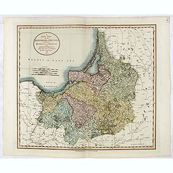
A New Map of the Kingdom of Prussia with its Divisions Into Provinces and Governments . . .
Highly detailed regional map of Prussia, including the Baltic regions and part of Poland, from Cary's Universal Atlas, one of the finest atlases of the period.
- $275 / ≈ €237
Date: London, 1799
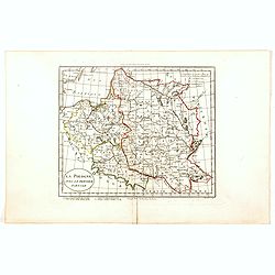
La Pologne avec le dernier partage.
Uncommon map of Poland and Lithuania. Engraved by Alexandre Blondeau (1799-1828), with Brezesci in the center of the map.From "Atlas universal pour la géographie de...
- $200 / ≈ €173
Date: Paris, Hyacinthe Langlois, 1799
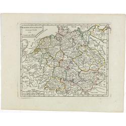
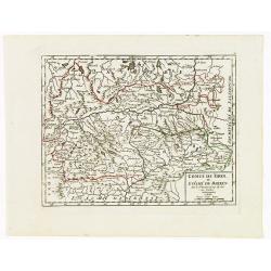
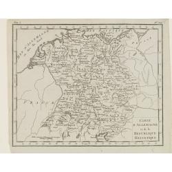
Empire d'Allemagne divisé par Cercles et Cours du Rhin.
Small detailed map of Germany, the Low Countries, Switzerland, Austria, Czechoslovakia and part of Poland.From Atlas Portatif Universel, by Robert de Vaugondy. Edited by ...
- $40 / ≈ €35
Date: Paris, 1799
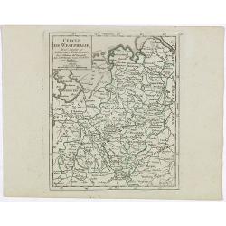
Cercle de Westphalie, divisé suivant ses différentes Principautés.
Small detailed map of the north western part of Germany, centred on Münster. From Atlas Portatif Universel, by Robert de Vaugondy.Edited by : "Au dépôt de Géogra...
- $30 / ≈ €26
Date: Paris, 1799
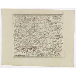
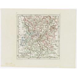
Cercle de Souabe où sont distingués les Enclaves de la Maison d'Autriche.
Small detailed map showing the state Baden-Württemberg, part of Bavaria and part of Austria.From Atlas Portatif Universel, by Robert de Vaugondy. Edited by : "Au d�...
- $70 / ≈ €60
Date: Paris, 1799
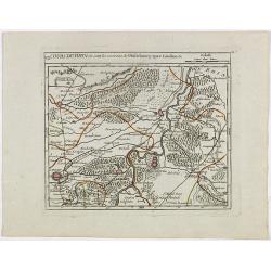
VII. Cours du Rhin où sont les environs de Philisbourg, Spire Landaw &c.
Small detailed map illustrating the stretch of the Rhine which flows between Germersheim and Speyer.From Atlas Portatif Universel, by Robert de Vaugondy. Edited by : &quo...
- $25 / ≈ €22
Date: Paris, 1799
Comté de Tirol, et Evêché de Brixen.
Small detailed map of Tirol and the Italian Alto-Adige region, centered on Innsbruck. From Atlas Portatif Universel, by Robert de Vaugondy.Edited by : "Au dépôt de...
Date: Paris, 1799
Cercle des quatre Electeurs.
Small detailed map of part of western Germany, centered on Frankfurt. From Atlas Portatif Universel, by Robert de Vaugondy.Edited by : "Au dépôt de Géographie, Ru...
Date: Paris, 1799
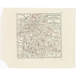
Cercle de Baviere où se trouvent le Palatinat de Baviere et l'Archev. De Saltzbourg.
Small detailed map of the southeastern part of Bavaria, including part of Austria. From Atlas Portatif Universel, by Robert de Vaugondy.Edited by : "Au dépôt de G�...
Date: Paris, 1799
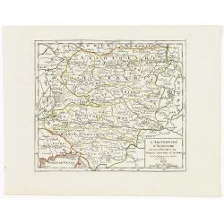
L'Archiduché d' Autriche et les Duchés de Stirie, Carinthie et Carniole.
Small detailed map of the eastern part of Austria, including Slovenia and part of Italy.From Atlas Portatif Universel, by Robert de Vaugondy. Edited by : "Au dépôt...
Date: Paris, 1799
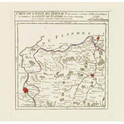
I. Carte du Comté du Haynaut.. Tournay.
Attractive small map encompassing part of Hainaut, between Tournai and Ath. From Atlas Portatif Universel, by Robert de Vaugondy.Edited by : "Au dépôt de Géograph...
Date: Paris, 1799
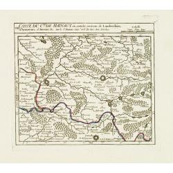
VIII. Carte du C.té de Haynaut où sont les environs de Landrechies..
Attractive small map showing an area straddling the regions Picardy and Nord. It shows the towns of La Capelle, Landrecies and Avesnes-sur-Helpe.From Atlas Portatif Unive...
Date: Paris, 1799
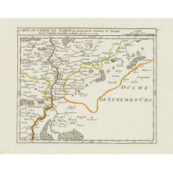
X. Carte du Comté de Namur où se trouvent les environs de Dinant.
Attractive small map showing an area straddling the border between France and Belgium.It shows Dinant, Ciney, and the fort of Charlemont, built by Charles V on the French...
Date: Paris, 1799

Erfolgte Kapitulation zwischen dem General Bonaparte und den Gross Leister von Malta. Vor der Hauptstadt Walette zu Maltha, am 10 Juni 1798.
Copper engraving with three scenes and one portrait on one sheet. In upper a view of Bonaparte arriving at Valletta. Published in "Allgemeine Welt-Chronik oder neue ...
Date: Zittau, 1798-1800
![[ Manuscript map of the Ligurian coast from Pietra to Genova ].](/uploads/cache/26627-250x250.jpg)
[ Manuscript map of the Ligurian coast from Pietra to Genova ].
Very detailed French manuscript map of the Ligurian coast from Pietra and Finale, Savone to Genoa with the Maritime Alps in the background. The Liguria coast borders to n...
Date: France, ca. 1790-1800
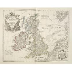
Les Isles Britanniques ou sont le Rme. D'Angleterre . . . Par G. De L'Isle. . . A Paris Chez Dezauche. . .
Uncommon late edition, (dated An 8, 1800 ) of this map of the British Isles prepared by DeL'Isle and published during the French Revolution by Dezauche / Buache. The bott...
Date: Paris, 1800
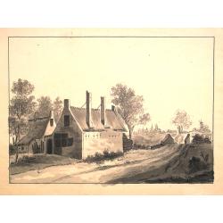
Dutch landscape.
Finely executed water color in pen and ink and gray wash color. Showing a Dutch landscape with farm house and windmills on the horizon.
- $60 / ≈ €52
Date: Probably The Netherlands, ca. 1800
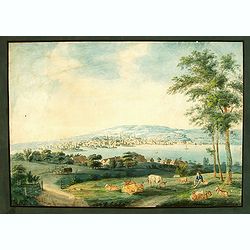
Vue de Zurich.
Good sized panoramic view of Zürich in the style of BLEULER with the foreground a resting shepherd with his sheep's under a tree. The engraving/etching is hand colored a...
- $900 / ≈ €777
Date: Ca. 1800

Deutschlands Postkarte begraenzt von Oesterreich, Preussen, Frankreich, Holland, Italien und der Schweiz. . .
A detailed and crucial post-road map prepared by Ignaz Heymann. The map shows the Low Countries, Germany, Poland, Austria, Hungary, etc.Borders in original outline colo...
Date: Triest, 1800
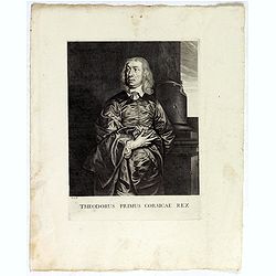
Theodorus Primus Corsicae Rex.
Portrait of Everard Jabach, three-quarter length, standing by the fragment of a column, facing left, wearing a cloak and doublet with plain collar, his left arm held behi...
Date: Paris, 1652 - 1800
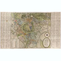
Plan de la ville de Rome, d'après celui publié par J.B. Nolli . . .
Beautiful town-plan of Rome, drawn up after the famous plan of Rome, executed by Giambattista Nolli in 1748. Decorated with a beautiful title cartouche topped by the coat...
- $1000 / ≈ €863
Date: Paris, Jean, 1801
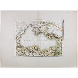
Carte de la Mer Noire ou Kara Degniz.
Original antique copper engraved map of the Black Sea with attractive original hand coloring.
- $200 / ≈ €173
Date: Paris, 1791-1801
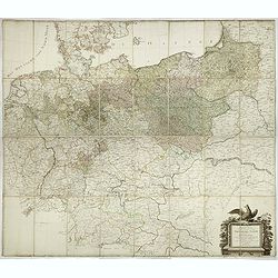
General Karte von den saemtlichen Kšnig. Preussischen Staaten welche zugleich als POSTKARTE durch die Länder der Preussischen Monarchie und durch ganz Deutschland diendt. . .
Large wall map (1,25 x 1,38 meters) of Prussia and present-day Poland, prepared by D.F. Sotzmann and published by Königl. Preuss. Academie Kunst und Buchhandlung.A detai...
- $1500 / ≈ €1295
Date: Berlin, 1802
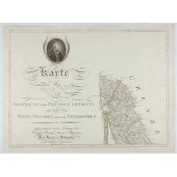
Karte von Ost-Preussen nebst Preussisch Litthauen und West-P
The title section of this important multi-sheet map of Prussia, Lithuania and Poland, showing territories of present Lithuania. With a medallion representing the King of ...
Date: Berlin, 1802

Teatro della guerra nelle Flandre Austriache e Francesi. . .
Rare folio-sized map of Belgium by Antonio Zatta e Figli, from a never-finished atlas by the ‘Società Calcografia’, a partnership of the two main Venetian publishers...
Date: Venise, 1803
![[2 maps] Des europäischen Russlands nördlicher Theil. / Des europäischen Russlands sûdlicher Theil.](/uploads/cache/34707-250x250.jpg)
[2 maps] Des europäischen Russlands nördlicher Theil. / Des europäischen Russlands sûdlicher Theil.
Detailed map of Russia in two sheets, published by Johannes Wach of Augsburg.
- $250 / ≈ €216
Date: Augsburg, 1803
Charte der Laender am Caucasus nach dem besten vorhanden Charten, Reisen, und astronomischen Ortbestimungen gezeichnet von I.C.Reinecke .
Scarce map of the Ukraine and Caucasus filled with great topographical detail, as well as numerous place names. According to the title the map has been drawn by Johann Ma...
- $750 / ≈ €647
Date: Weimar, 1803
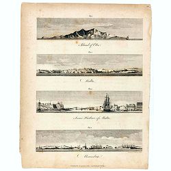
Island of Elba / Malta / Inner harbour of Malta / Alexandria.
Four views on a sheet, engraved by S.I Neele. Profile views of the island of Elba, Alexandria and two profile views of Malta and the Inner Harbour in Valletta.
Date: London, 1803
Carte générale des marches, positions, combats et batailles de l'Armée de réserve. . . (N°12)
Very detailed map centered on the Italian Alps showing the marches, positions, combats and battles of the famous Napoleon's crossing the Alps in the year 8 (1799) . In an...
- $750 / ≈ €647
Date: Paris, 1803
Carte de l'Europe dediée a Son Altesse royale Monseigneur Charles Louis archiduc d'Autriche, prince royal de Hongrie et de Bohéme, chevalier de la Toison d'Or, Grand-Croix de l'ordre...
Probably the largest published map of Europe during the regime of Napoleon.In upper left corner a large title cartouche with coats of arms and a dedication to Archduke Ch...
- $4000 / ≈ €3453
Date: Paris, 1803
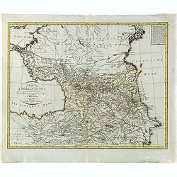
Niederungern Ivtes Blatt enthaltend die Schumegher, Tolner, Baranyer. . . Partie IVè de la basse hongrie contenant les comtes de Schumegh, de Tolna, de Baranya. . .
Map of Hungary. In the lower explicative key. Detailed map of the Southern part of Hungary with Kopreinitz until Lake Balaton, which is one of the most popular summer des...
Date: Kunst u. Industrie Compt., Vienna, 1803
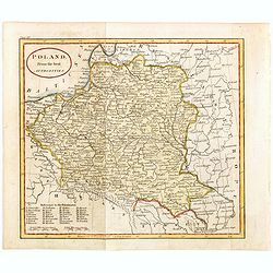
Poland from the best authorities.
Detailed map of Poland from "A New Geographical, Historical, and Commercial Grammar", by William Guthrie. William Guthrie (later engraver for Carey) London, UK....
Date: London, 1805
Die Götha-Elf. Nach Friedr. Akrel's Plancharta öfver Trollhättan reducirt.
Uncommon map prepared by Carl Frederik Akrell. Showing the River Gotha from Gothenburg till Vänersborg.Published by Geographisen Institut in Weimar. A scale in Swedish m...
- $100 / ≈ €86
Date: Weimar, 1805
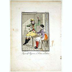
Paysan & Paysanne d'Hanas en Boheme.
Originally hand-colored mezzotint from 'Costumes civils actuels de tous les peuples connus'. Engraved by Lachaussée Jeune after Jacques Grasset de Saint-Sauveur.As an et...
- $50 / ≈ €43
Date: Paris,1805
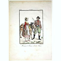
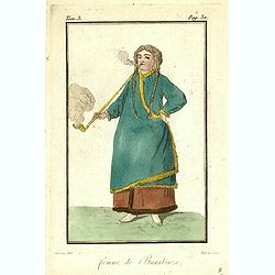
Homme & et Femme de la Sirie.
Originally hand-colored mezzotint from 'Costumes civils actuels de tous les peuples connus'. Engraved by Félix Mixelle after Jacques Grasset de Saint-Sauveur.As an etche...
- $50 / ≈ €43
Date: Paris,1805
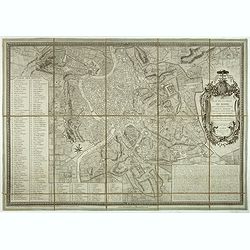
Plan de la ville de Vienne et de ses faubourgs divisés en quartiers.
Fine plan of Vienna, engraved by Franz T. Müller and published by Jean Crappi. On both side an extensive key and a color key to the different sectors in town.
- $900 / ≈ €777
Date: Vienna, 1805
L'Isle de CORSE Divisée en ses departemens.
Nice map of Corsica, with a decorative cartouche in the left low corner. Small inset map of Sicily in the upper right corner: "Pointe de Capo Corso".This is the...
- $1750 / ≈ €1511
Date: Venise,1805
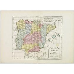
L'Espagne et le Portugal. Divisés Par Gdes. Provinces.
Map of Spain and Portugal, including the Balearic Islands archipelago. From Atlas de la Géographie de toutes les parties du monde .. Ouvrage destiné pour l'education, e...
- $80 / ≈ €69
Date: Paris, Prudhomme, Levrault, Debray, 1806
Royaumes d'Espagne et du Portugal.
Map of Spain and Portugal. By C. F. Delamarche, successor of Robert de Vaugondy, Geographer.
- $80 / ≈ €69
Date: Paris, 1794 - 1806
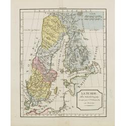
La Suède.
Map of Sweden and Finland. By C. F. Delamarche, successor of Robert de Vaugondy, Geographer.
Date: Paris, ca.1806
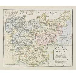
Cercle de Haute Saxe et de Basse Saxe. . .
Map of the duchies of Saxony (upper & lower). By C. F. Delamarche, successor of Robert de Vaugondy, Geographer.
- $50 / ≈ €43
Date: Paris, 1794 - 1806
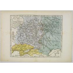
Partie Méridionale de la Russie Européenne, Tartarie, Russienne, Petite Tartarie.
Map of the southern part of Russia and Tartary. By C. F. Delamarche, successor of Robert de Vaugondy, Geographer.
- $90 / ≈ €78
Date: Paris, 1806
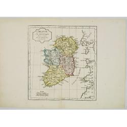
L' Irlande.
Map of Ireland. By C. F. Delamarche, successor of Robert de Vaugondy, Geographer.
- $90 / ≈ €78
Date: Paris, 1794 - 1806
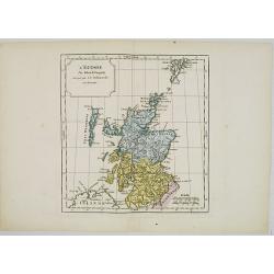
L' Ecosse.
Map of Scotland. By C. F. Delamarche, successor of Robert de Vaugondy, Geographer.
- $50 / ≈ €43
Date: Paris, 1794 - 1806
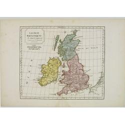
Les Isles Britanniques.
Map of British Isles. By C. F. Delamarche, successor of Robert de Vaugondy, Geographer.
- $80 / ≈ €69
Date: Paris, 1794 - 1806
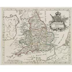
Carte du Royaume d' Angleterre . . .
Map of England and its counties, from Atlas moderne portatif composé de vingt-huit cartes sur toutes les parties du globe terrestre .. A l'usage des Colléges, des Pensi...
Date: Paris, Prudhomme, Levrault, Debray, 1806
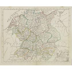
L'Allemagne . . .
Map of Germany, from Atlas moderne portatif composé de vingt-huit cartes sur toutes les parties du globe terrestre .. A l'usage des Colléges, des Pensions & des Mai...
- $50 / ≈ €43
Date: Paris, Prudhomme, Levrault, Debray, 1806
Carte d' Italie . . .
Map of Italy from Atlas moderne portatif composé de vingt-huit cartes sur toutes les parties du globe terrestre .. A l'usage des Colléges, des Pensions & des Maison...
Date: Paris, Prudhomme, Levrault, Debray, 1806
L' Espagne et le Portugal . . .
Map of Spain and Portugal, from Atlas moderne portatif composé de vingt-huit cartes sur toutes les parties du globe terrestre .. A l'usage des Colléges, des Pensions &a...
Date: Paris, Prudhomme, Levrault, Debray, 1806
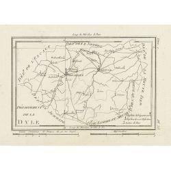
Département de la Dyle.
Map centered on Bruxelles with a short key list in the lower right corner. From Atlas de la Géographie de toutes les parties du monde .. Ouvrage destiné pour l'educatio...
- $40 / ≈ €35
Date: Paris, Prudhomme, Levrault, Debray, 1806
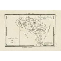
Département de Jemmape.
Map representing the area around Mons, with a short key list in the lower right corner.From Atlas de la Géographie de toutes les parties du monde .. Ouvrage destiné pou...
- $30 / ≈ €26
Date: Paris, Prudhomme, Levrault, Debray, 1806
Département de la Meuse Inf.re.
Map representing the area around Maastricht, with a short key list in the lower right corner.From Atlas de la Géographie de toutes les parties du monde .. Ouvrage destin...
- $40 / ≈ €35
Date: Paris, Prudhomme, Levrault, Debray, 1806
Carte d'Allemagne et de la Republique Helvetique.
Map of central Europe centered on Germany, extending southwards and eastwards to include Poland, the Czech Republic, Austria, Switzerland, Slovenia and part of Italy.From...
Date: Paris, Prudhomme, Levrault, Debray, 1806
Femme Mordivine.
Originally hand-colored mezzotint of a Mordvinian woman from Ural region dressed in native garb, engraved by Félix Mixelle and Lachaussée Jeune after Jacques Grasset de...
Date: Paris,1801-1806
Femme de Barabinze.
Originally hand-colored mezzotint of a woman from Barabinze, engraved by Félix Mixelle and Lachaussée Jeune after Jacques Grasset de Saint-Sauveur.As an etcher, drawer ...
Date: Paris,1801-1806
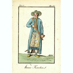
Homme Kouritien.
Originally hand-colored mezzotint of a Siberian man dressed in native garb, engraved by Félix Mixelle and Lachaussée Jeune after Jacques Grasset de Saint-Sauveur.As an ...
Date: Paris,1801-1806
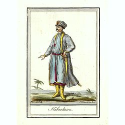
Kabardinien.
Originally hand-colored costume mezzotint of a Kabardian from the Northwest Caucasus, engraved by Félix Mixelle and Lachaussée Jeune after Jacques Grasset de Saint-Sauv...
Date: Paris,1801-1806
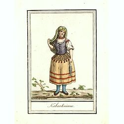
Kabardinienne.
Originally hand-colored costume mezzotint of a Kabardian woman from the Northwest Caucasus, engraved by Félix Mixelle and Lachaussée Jeune after Jacques Grasset de Sain...
Date: Paris,1801-1806
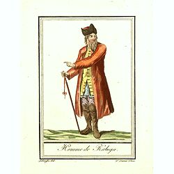
Homme de Kaluga.
Originally hand-colored costume mezzotint of a man from Kaluga engraved by Félix Mixelle and Lachaussée Jeune after Jacques Grasset de Saint-Sauveur.As an etcher, drawe...
Date: Paris,1801-1806
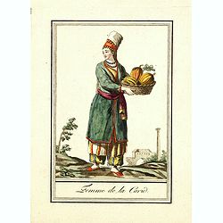
Femme de la Carie.
Originally hand-colored mezzotint costume plate of a woman from the Republic of Karelia, engraved by Félix Mixelle and Lachaussée Jeune after Jacques Grasset de Saint-S...
Date: Paris,1801-1806
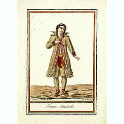
Femme Samoïede.
Originally hand-colored mezzotint of a Samoïede woman engraved by Félix Mixelle and Lachaussée Jeune after Jacques Grasset de Saint-Sauveur.As an etcher, drawer and wr...
Date: Paris,1801-1806
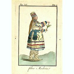
![Fille Mordwine en habits de nôces [together with] Fille Mordwine.](/uploads/cache/36932-250x250.jpg)
Fille Mordwine en habits de nôces [together with] Fille Mordwine.
Set of two originally hand-colored mezzotints of Native Russians engraved by Félix Mixelle and Lachaussée Jeune after Jacques Grasset de Saint-Sauveur.As an etcher, dra...
- $50 / ≈ €43
Date: Paris,1801-1806
![Femme Baschkir [together with] Homme Baschkir.](/uploads/cache/36933-250x250.jpg)
Femme Baschkir [together with] Homme Baschkir.
Set of two originally hand-colored mezzotints of Native Russians engraved by Félix Mixelle and Lachaussée Jeune after Jacques Grasset de Saint-Sauveur.As an etcher, dra...
- $50 / ≈ €43
Date: Paris,1801-1806
![Kirguise [together with] Fille Fatar Kastchintz.](/uploads/cache/36937-250x250.jpg)
Kirguise [together with] Fille Fatar Kastchintz.
Set of two originally hand-colored mezzotints of Native Russians engraved by Félix Mixelle and Lachaussée Jeune after Jacques Grasset de Saint-Sauveur.As an etcher, dra...
- $50 / ≈ €43
Date: Paris,1801-1806
![Homme Fatar Kastchintz [together with] Femme Fatar Kastchintz.](/uploads/cache/36938-250x250.jpg)
Homme Fatar Kastchintz [together with] Femme Fatar Kastchintz.
Set of two originally hand-colored mezzotints of Native Russians engraved by Félix Mixelle and Lachaussée Jeune after Jacques Grasset de Saint-Sauveur.As an etcher, dra...
- $50 / ≈ €43
Date: Paris,1801-1806
![Homme de Tobolsk [together with] Femme Fatar Tobolsk.](/uploads/cache/36939-250x250.jpg)
Homme de Tobolsk [together with] Femme Fatar Tobolsk.
Set of two originally hand-colored mezzotints of Native Russians engraved by Félix Mixelle and Lachaussée Jeune after Jacques Grasset de Saint-Sauveur.As an etcher, dra...
- $50 / ≈ €43
Date: Paris,1801-1806
![Homme Morwine [together with] Femme Mordwine.](/uploads/cache/36920-250x250.jpg)
Homme Morwine [together with] Femme Mordwine.
Set of two originally hand-colored mezzotints of Native Russians engraved by Félix Mixelle and Lachaussée Jeune after Jacques Grasset de Saint-Sauveur.As an etcher, dra...
- $50 / ≈ €43
Date: Paris,1801-1806
![Femme Tscheremisse [together with] Homme Tscheremisse.](/uploads/cache/36921-250x250.jpg)
Femme Tscheremisse [together with] Homme Tscheremisse.
Set of two originally hand-colored mezzotints of Native Russians engraved by Félix Mixelle and Lachaussée Jeune after Jacques Grasset de Saint-Sauveur.As an etcher, dra...
- $50 / ≈ €43
Date: Paris,1801-1806
![Homme Kamtschadale [together with] Femme Kamtschadale.](/uploads/cache/36922-250x250.jpg)
Homme Kamtschadale [together with] Femme Kamtschadale.
Set of two originally hand-colored mezzotints of Native Russians engraved by Félix Mixelle and Lachaussée Jeune after Jacques Grasset de Saint-Sauveur.As an etcher, dra...
Date: Paris,1801-1806
![Femme Samoïede [together with] Homme Samoïede.](/uploads/cache/36923-250x250.jpg)
Femme Samoïede [together with] Homme Samoïede.
Set of two originally hand-colored mezzotints of Native Russians engraved by Félix Mixelle and Lachaussée Jeune after Jacques Grasset de Saint-Sauveur.As an etcher, dra...
- $50 / ≈ €43
Date: Paris,1801-1806
![Femme Ostyack [together with] Homme Ostyack.](/uploads/cache/36924-250x250.jpg)
Femme Ostyack [together with] Homme Ostyack.
Set of two originally hand-colored mezzotints of Native Russians engraved by Félix Mixelle and Lachaussée Jeune after Jacques Grasset de Saint-Sauveur.As an etcher, dra...
- $50 / ≈ €43
Date: Paris,1801-1806
![Kabardinien [together with] Kabardinienne.](/uploads/cache/36925-250x250.jpg)
Kabardinien [together with] Kabardinienne.
Set of two originally hand-colored mezzotints of Native Russians engraved by Félix Mixelle and Lachaussée Jeune after Jacques Grasset de Saint-Sauveur.As an etcher, dra...
- $50 / ≈ €43
Date: Paris,1801-1806