Browse Listings in Europe
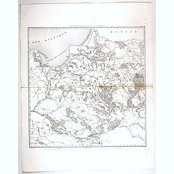
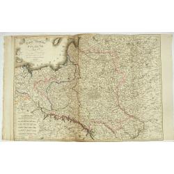
![[Untitled map of a part of Poland and Prussia].](/uploads/cache/25710-250x250.jpg)
[Untitled map of a part of Poland and Prussia].
Large folding map, being upper right part of a multi-sheet map, showing the northern part of Poland with good detail around Gdansk. Published by Jean Claude Dezauche (17...
- $400 / ≈ €345
Date: Paris, ca. 1816-1824
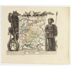
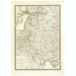
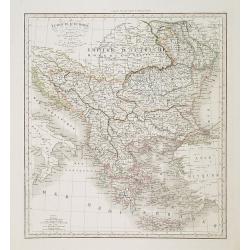
Russie
Attractive map of Russia with decorative borders depicting typical artefacts and produce of the continent. Published in Les jeunes voyageurs en Europe.. . Engraved by J.G...
- $100 / ≈ €86
Date: Brussels, 1824

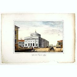
Le Chantier d'Amsterdam.
Decorative lithography representing the head quarters of the V.O.C. and shipyard in Amsterdam. The building serves nowadays as the Maritime Museum. After a painting by A....
Date: Brussels, J. B. A. Jobard, 1825
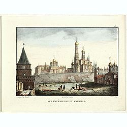
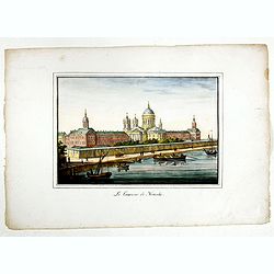
Vue du Kremlin à Moscou.
View of the Kremlin, lithographed by Brocas after a design by Edouard de Montulé. Lithography was printed by Langlumé in Paris. Taken from : Voyage en Angleterre et en ...
- $125 / ≈ €108
Date: Paris, Arthus Bertrand, 1825
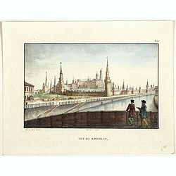
Vue du Kremlin.
View of the Kremlin, lithographed by Brocas after a design by Edouard de Montulé. Lithography was printed by Langlumé in Paris. Taken from : Voyage en Angleterre et en ...
- $125 / ≈ €108
Date: Paris, Arthus Bertrand, 1825
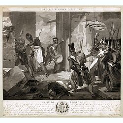
Dédié à l'armée d'Espagne. Prise de Logrono.
Very decorative plate showing the taking of Logrono in 1823, decorative mezzotint by Louis-François Charon (1783-1839) after F.N.Martinet. Published by Jean, Editeur, Ma...
Date: Paris, 1825

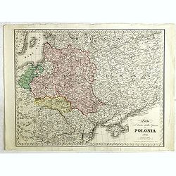
Province de Pologne contenant 22 Col. une M.on Prof 5 Pen. 2 Nov. 6 Rés. 30 Maisons 1050 Jésuites.
Rare map of Poland from "Atlas Universel indiquant les établissemens des Jésuites: avec la manière dont ils divisent la terre, suivi desévénemens remarquables d...
Date: Paris, Ambroise Dupont , 1826
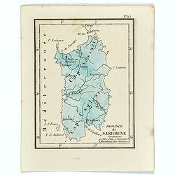
Province de Sardaigne.
Province de Sardaigne Contenant 9 Col. 1 Sem. 1 Noviciat, 2 Résidences 300 Jésuites". Publiée dans "Atlas Universel indiquant les établissemens des Jésuite...
Date: Paris, Ambroise Dupont , 1826
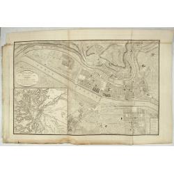
Nouveau Plan Géométral de la Ville de Lyon, Avec ses projets d'agrandissement & d'embellissement, Divisé par Arrondissements;
Large map of Lyon with, at the bottom left, a large inset depicting "The surroundings of Lyon, according to Cassini" and at the bottom right, a double table of ...
Date: Lyon, Chez Vegezzy, M.d d'Estampes,1826
Habillement des Groënlandais.
Natives of Greenland. This aquatint engraved plate was color printed on fine wove paper of a soft aged white color, bearing the embossed seal of authenticity impressed at...
- $75 / ≈ €65
Date: Milan, 1827

Bernoise.
A decorative costume print from "Costume de div. Pays", No.17. Engraved by Getine after Lanté.
- $80 / ≈ €69
Date: Paris, c. 1827
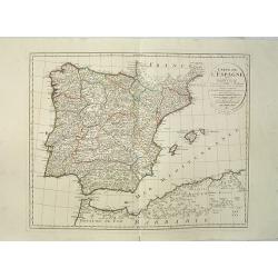
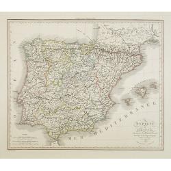
Carte de l'Espagne Dressée par Guillaume Delisle sur la description de Rodrigo Mendez Sylva . . .. Le tout augmenté et vérifié en 1789. Par Phil. Buache, de l'Académie des Sciences.
Map of Spain and Portugal, including the North African coast and good detail for Majorca, Minorca and Ibiza. Published by Dezauche at his address Rue de Sorbonne, n°9, a...
Date: Paris, 1827
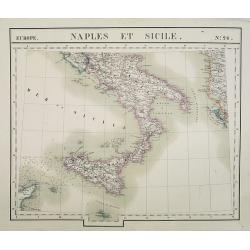
Europe. Naples et Sicile. N.26.
Detailed map including lower half of Italy with the island of Sicily.From his famous Atlas Universel . This atlas was one of the most remarkable world atlases ever produc...
Date: Brussels, 1825-1827
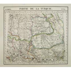
Europe. Partie de la Turquie. N°21.
Detailed map including Hungary and Romania.From his famous Atlas Universel . This atlas was one of the most remarkable world atlases ever produced, anticipating the Inter...
Date: Brussels, 1825-1827
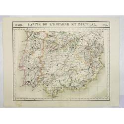
Europe. Partie de l'Espagne et Portugal. N°24.
Detailed map including Southern part of Spain and Portugal.From his famous Atlas Universel . This atlas was one of the most remarkable world atlases ever produced, antici...
Date: Brussels, 1825-1827
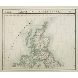
Europe. Partie de l'Angleterre. N°7.
Detailed map including Northern part of England.From his famous Atlas Universel . This atlas was one of the most remarkable world atlases ever produced, anticipating the ...
- $100 / ≈ €86
Date: Brussels, 1825-1827
![[ Spitzbergen ]](/uploads/cache/27541-250x250.jpg)
[ Spitzbergen ]
Two aquatints depicting the northern coasts of the Spitzbergen engraved by Fumagalli. From Giulio Ferrario's work Le Costume Ancien et Moderne ou Histoire du gouverneme...
Date: Milan, 1827
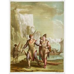
![[Costume plate of Grebenski Cossacks in the Caucasus]](/uploads/cache/62339-250x250.jpg)
[Costume plate of Grebenski Cossacks in the Caucasus]
Aquatint costume plate of Grebenski Cossacks in the Caucasus. Plate N° 10. From Giulio Ferrario's work Le Costume ancien et moderne ou histoire du gouvernement, de la mi...
Date: Milan, 1827
![[Costumes des Karabulaks - Caucase]](/uploads/cache/62344-250x250.jpg)
[Costumes des Karabulaks - Caucase]
Four men from the Caucasus in typical dress from the Karabulaks tribe. Plate N° 15. from Giulio Ferrario's work "Le Costume Ancien et Moderne ou Histoire du gouvern...
Date: Milan, 1827

Intérieur d'une maison groënlandaise.
This aquatint engraved plate was color printed on fine move paper of a soft aged white color, bearing the embossed seal of authenticity impressed at the time of publicati...
- $75 / ≈ €65
Date: Milan 1827
![[Calmucchi].](/uploads/cache/34988-250x250.jpg)
[Calmucchi].
Aquatint costume plate of the Kalmyk people. The name is given to the Oirats in Russia, whose ancestors migrated from Dzungaria in 1607. They created the Kalmyk Khanate i...
- $50 / ≈ €43
Date: Milan, 1827
Carte de la Russie occidentale et du Royme. de Pologne par A. Brue, Geographe du Roi . . .
Steel engraved map of Russia and Poland from his "Universal Atlas of physical geography, politics, ancient & modern."
- $150 / ≈ €129
Date: Paris, 1827
Le couvent de Nenski.
A rare lithography published by Alexandre Ivanovitch Pluchard (1777-1832) in St.-Petersburg, one of the first lithographs made in St. Petersburg. The lithographs are publ...
- $550 / ≈ €475
Date: St.-Petersburg, 1827
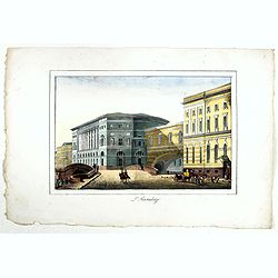
![[Untitled]. St. Petersburg.](/uploads/cache/37444-250x250.jpg)
[Untitled]. St. Petersburg.
A rare lithography published by Alexandre Ivanovitch Pluchard (1777-1832) in St.-Petersburg, one of the first lithographs made in St. Petersburg. The lithographs are publ...
- $400 / ≈ €345
Date: St.-Petersburg, 1827
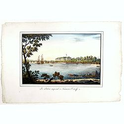
Le Palais imperial a Kamenoi Ostroff.
Fine lithography published by Alexandre Pluchart in St.-Petersburg, one of the first lithographs made in St. Petersburg. The lithographs are published in installments. Th...
- $450 / ≈ €388
Date: St.-Petersbourg, 1827
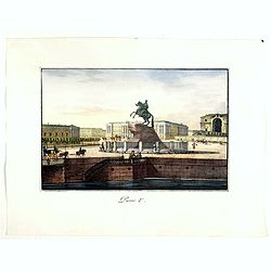
Pierre Ier.
A rare lithography published by Alexandre Ivanovitch Pluchard (1777-1832) in St.-Petersburg, one of the first lithographs made in St. Petersburg. The lithographs are publ...
- $500 / ≈ €432
Date: St.-Petersburg, 1827
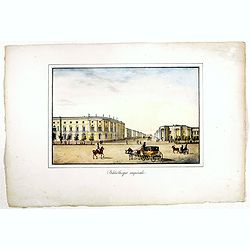
Bibliotheque imperiale.
Fine lithography published by Alexandre Ivanovitch Pluchard (1777-1832) in St.-Petersburg, one of the first lithographs made in St. Petersburg. The lithographs are publis...
- $450 / ≈ €388
Date: St.-Petersburg, 1827
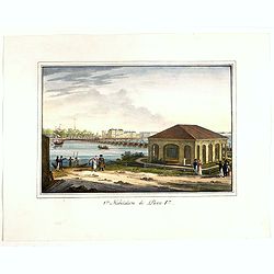
1ère habitation de Pierre 1er.
A rare lithography published by Alexandre Ivanovitch Pluchard (1777-1832) in St.-Petersburg, one of the first lithographs made in St. Petersburg. The lithographs are publ...
- $275 / ≈ €237
Date: St.-Petersburg, 1827
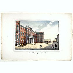
Le palais du Grand Duc Nicolas.
Fine and rare lithography published by Alexandre Ivanovitch Pluchard (1777-1832) in St.-Petersburg, one of the first lithographs made in St. Petersburg. The lithographs a...
- $750 / ≈ €647
Date: St.-Petersburg, 1827
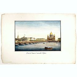
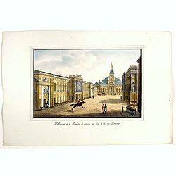
Pont d'Isaac et nouvelle Eglise.
A rare lithography published by Alexandre Pluchart in St.-Petersburg, one of the first lithographs made in St. Petersburg. The lithographs are published in installments. ...
- $500 / ≈ €432
Date: St.-Petersburg, 1827
L'Hermitage.
A rare lithography published by Alexandre Pluchart in St.Petersburg, one of the first lithographs made in St. Petersburg. The lithographs are published in installments. T...
- $500 / ≈ €432
Date: St.Petersburg, 1827
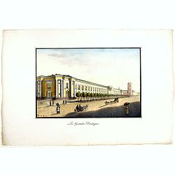
Les Grandes Boutiques.
Fine lithography published by Alexandre Ivanovitch Pluchard (1777-1832) in St.-Petersburg, one of the first lithographs made in St. Petersburg. The lithographs are publis...
- $400 / ≈ €345
Date: St.-Petersburg, 1827
Arsenal et la Fonderie de canons, au bout de la rue Litaiyana.
A rare lithography published by Alexandre Ivanovitch Pluchard (1777-1832) in St.-Petersburg, one of the first lithographs made in St. Petersburg. The lithographs are publ...
- $450 / ≈ €388
Date: St.-Petersburg, 1827
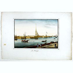
La Forteresse.
Fine lithography published by Alexandre Ivanovitch Pluchard (1777-1832) in St.-Petersburg, one of the first lithographs made in St. Petersburg. The lithographs are publis...
- $450 / ≈ €388
Date: St.-Petersburg, 1827
Eglise de la Vierge des Affligés.
A rare lithography published by Alexandre Ivanovitch Pluchard (1777-1832) in St. Petersburg, one of the first lithographs made in St. Petersburg. The lithographs are publ...
- $500 / ≈ €432
Date: St.-Petersburg, 1827
Espagne et Portugal . . .
Detailed map of Spain and Portugal, Majorca and Minorca, etc., prepared by A. H. Basset, rue Saint-Jacques, no. 64, Paris and published in Atlas Classique et Universel de...
- $100 / ≈ €86
Date: Paris, A.H. Basset, 1828
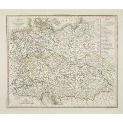
Allemagne . . .
Detailed map of Germany and Austria, prepared by A. H. Basset, rue Saint-Jacques, no. 64, Paris and published in Atlas classique et Universel de Géographie . . . .The en...
- $80 / ≈ €69
Date: Paris, A.H. Basset, 1828
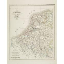
Royaume des Pays-Bas . . .
Detailed map of the Netherlands, Belgium and Luxembourg, prepared by A. H. Basset, rue Saint-Jacques, no. 64, Paris and published in Atlas classique et Universel de Géog...
Date: Paris, A.H. Basset, 1828
Turquie d'Europe . . .
Detailed map of Grrece, Marcedonia, Bulgaria, Servia, Roumania, prepared by A. H. Basset, rue Saint-Jacques, no. 64, Paris and published in Atlas classique et Universel d...
- $80 / ≈ €69
Date: Paris, A.H. Basset, 1828
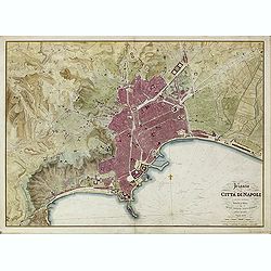
Pianta della Citta di Napoli e de' soui contorni.
Uncommon large scale town-plan of Naples. Drawn and engraved by the "Reale officio topografico".
- $1500 / ≈ €1295
Date: Naples, 1828
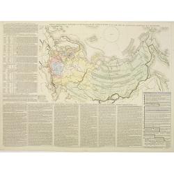
Tablaeu géographique statistique &C. de l'empire Russe actuel en Europe et en Asie avec ses aquisitions graduelles et caractérisées.
Map showing the extension of the Russian Empire at the beginning of the 19th century. Several letterpress notations are present on the map.Surrounding letterpress explana...
Date: Paris, Paul Renouard, 1828
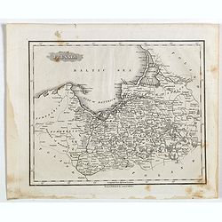
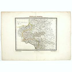
Part of Prussia.
Attractive example of the scarce 1828 Malte-Brun map of modern day Poland and Lithuania. Published by Samuel Walker in 1828 as part of the American edition of Conrad Malt...
- $100 / ≈ €86
Date: Boston, 1828

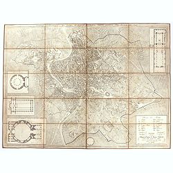
Pianta Della Citta di Roma con la Indicazione di tutte le Antichita e Nuovi Abbelliment.
Beautifully engraved town plan of Rome, featuring side borders that depict the 16 most important monuments, along with a legend that locates the significant places and bu...
Date: Venanzio Monaldini, Rome, 1829
Pianta topografica di Roma moderna estratta dalla grande del Nolli an 1829
Town plan of Rome based on map by Giovanni Battista Nolli, ( fl. 1692-1756). Engraved by Pietro Ruga. With a key (I - XIV), scale and text "Nuova pianta di Roma mode...
Date: Rome, 1829
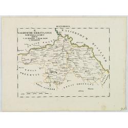
B. Galizische Erbstaaten Koenigr: Galizien Kreis 1. Lemberg 2. Zloczow 3. Zolkiew.
Map depict the western part of the Ukraine, centered on the town of Lviv (Lemberg) the former capital of the region of Galicia. Other cities are Zolkiew, Brody, Belz.From...
- $300 / ≈ €259
Date: Leipzig, G. J. Göschen, ca 1825-1830
![[No title] Russland.](/uploads/cache/28943-250x250.jpg)
[No title] Russland.
Map depict the area north of the Black Sea, including the cities of Odessa, Kischenau, Jelisawetgrad, Kherson.From "W. E. A. von Schliebens Atlas von Europa nebst Ko...
- $250 / ≈ €216
Date: Leipzig, G. J. Göschen, ca 1825-1830
![[No title] Russland.](/uploads/cache/28944-250x250.jpg)
[No title] Russland.
Map depict the area north of the Black Sea, including the cities of Jekaterinoslaw, Bachmut, Alexandrowsk.From "W. E. A. von Schliebens Atlas von Europa nebst Koloni...
- $300 / ≈ €259
Date: Leipzig, G. J. Göschen, ca 1825-1830
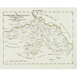
Oesterreich. B. Galizische Erbstaaten Koenigr: Galizien Kreis 1. Lemberg 2. Zloczow 3. Zolkiew.
Map depict the area north of the Black Sea, including the cities of Lemberg, Zolkiew, Brody.From "W. E. A. von Schliebens Atlas von Europa nebst Kolonien für Gesch�...
- $150 / ≈ €129
Date: Leipzig, G. J. Göschen, ca 1825-1830
![[No title] Oesterreich. B. Galizische erbstaaten Koenigr. Galizien Kreis 12. Sambor 13. Stry 17. Stanislawow.](/uploads/cache/28948-250x250.jpg)
[No title] Oesterreich. B. Galizische erbstaaten Koenigr. Galizien Kreis 12. Sambor 13. Stry 17. Stanislawow.
Map depict the area north of the Black Sea, including the cities of Stanislawow, Drobicz, Sambor.From "W. E. A. von Schliebens Atlas von Europa nebst Kolonien für G...
- $300 / ≈ €259
Date: Leipzig, G. J. Göschen, ca 1825-1830
![[No title] Russland. Gouv. 24 Woronesh 28. Slobodsk Ukraine.](/uploads/cache/28949-250x250.jpg)
[No title] Russland. Gouv. 24 Woronesh 28. Slobodsk Ukraine.
Map depict the area north of the Black Sea, including the cities of Kharkow, Achtyrka, Woronesh, etc.From "W. E. A. von Schliebens Atlas von Europa nebst Kolonien f�...
- $300 / ≈ €259
Date: Leipzig, G. J. Göschen, ca 1825-1830
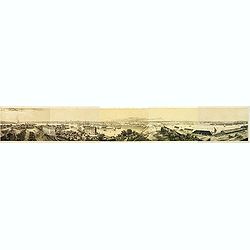
Panorama de Stockholm, Pris de la Coupole de L'Eglise de Skeppsholmen (5 sheets)
Panorama of Stockholm, with numerous captions describing buildings, showing the city as it was in the mid-19th century. On five sheets not joined, total 283 x 2175 mm, fr...
- $400 / ≈ €345
Date: Paris, 1830
Carte du pays compris entre Vistule et la Pregel.
Map of Poland regions, including Warsaw, part of Russia and Danzig bay, prepared by Auguste Henri Dufour (1798-1865). Engraved by Ch. Dyonnet.
- $75 / ≈ €65
Date: Paris, 1830
Carta del Teatro della Guerra in Polonia - 1831.
Oversized rare 1831 war map of Poland and Lithuania published during the Polish - Russian War in 1831, published by Presso l'incisore Stanislao Stucchi. Stucchi, was born...
- $900 / ≈ €777
Date: Milan, 1831
Reino de Polonia ò sea la parte unida a la Rusia por el repartimiento de 1795 que conserva el nombre de aquel antiguo reino.
Uncommon Spanish map of Poland from "Coleccion de mapas geograficos antiguos y modernos de autores clascicos", published by José Torner in Barcelona in 1831.R....
Date: José Torner, Barcelona, 1831
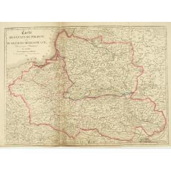
Carte des Etats de Pologne et du Grand Duché de Lithunanie.
Uncommon map of Poland prepared by Sanson and revised by Eustache Hérisson (1759-18.. ) and engraved by Cordier. The map was published by the last family member of the J...
Date: Paris, Jean, 1831
Carte Routière de la Pologne indiquant les partages de ce Royaume…
Carte Routière de la Pologne indiquant les partages de ce Royaume qui ont été faits depuis 1772, 1795 &a". Map prepared by Hérisson and published by Basset. ...
Date: Paris, Basset, 1831

Nouveau Plan Routier de la Ville et Faubourgs de Paris // Avec ses principaux Edifices et Nouvelles Barrieres.
Decorative large-scale wall map of Paris, published by M. P|chon in Paris and engraved by Michel Glot. The plan is framed by a floral border and there are 27 Parisian vie...
Date: Paris, 1834
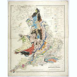
The Inland Navigation, Rail Roads, Geology and Minerals of England & Wales.
A beautifully color-coded and robustly labelled map describes the geology of England and Wales. The colors indicate particular rock materials in accordance with a key at ...
Date: London, 1834
Sewastopol. (Sebastopol)
View of Sebastopol. Engraved by Leopold Zechmayer who was active in Vienna.
- $20 / ≈ €17
Date: Vienna, ca. 1835
Quartier de Tivoli Nouveaux pereements de Rues.
Plan of the center of Paris showing Tivoli district with Madalene and Clichy. Lithography and pen and ink. Drawn in are the planned workshop of Serrurerie Théophile Mign...
Date: Paris, ca.1835
![Portatori d'acqua. Porteurs d'eau. [Water Carriers of Venice]](/uploads/cache/49432-250x250.jpg)
Portatori d'acqua. Porteurs d'eau. [Water Carriers of Venice]
Water Carriers. From a series of lithographs depicting various Venetian trades, published in Venice by Galvani. Subjects include genre figures such as fishmongers, chimne...
Date: Venice, c. 1835
![Venditori du zucca. Vendeurs de courge. [Pumpkin Sellers of Venice]](/uploads/cache/49433-250x250.jpg)
Venditori du zucca. Vendeurs de courge. [Pumpkin Sellers of Venice]
Pumpkin Sellers. From a series of lithographs depicting various Venetian trades, published in Venice by Galvani. Subjects include genre figures such as fishmongers, chimn...
Date: Venice, c. 1835
![Venditrici di latte. Laitières. [Milkmaids of Venice]](/uploads/cache/49429-250x250.jpg)
Venditrici di latte. Laitières. [Milkmaids of Venice]
Milkmaids. From a series of lithographs depicting various Venetian trades, published in Venice by Galvani.Subjects include genre figures such as fishmongers, chimney swee...
Date: Venice, c. 1835
![Venditori di pesci (Anguele). Marchands de petite poissons. [Fish Sellers of Venice]](/uploads/cache/49430-250x250.jpg)
Venditori di pesci (Anguele). Marchands de petite poissons. [Fish Sellers of Venice]
Small Fish Sellers. From a series of lithographs depicting various Venetian trades, published in Venice by Galvani. Subjects include genre figures such as fishmongers, ch...
Date: Venice, c. 1835
![Gondolieri privati. Les Gondoliers particuliers. [Private Gondoliers of Venice]](/uploads/cache/49431-250x250.jpg)
Gondolieri privati. Les Gondoliers particuliers. [Private Gondoliers of Venice]
Private Gondoliers. From a series of lithographs depicting various Venetian trades, published in Venice by Galvani. Subjects include genre figures such as fishmongers, ch...
Date: Venice, c. 1835
![Fruttajuoli. Fruittiers. [Fruit Sellers of Venice]](/uploads/cache/49434-250x250.jpg)
Fruttajuoli. Fruittiers. [Fruit Sellers of Venice]
Fruit Sellers. From a series of lithographs depicting various Venetian trades, published in Venice by Galvani.Subjects include genre figures such as fishmongers, chimney ...
Date: Venice, c. 1835
![Carbonaj. Charbonniers. [Charcoal Sellers of Venice]](/uploads/cache/49435-250x250.jpg)
Carbonaj. Charbonniers. [Charcoal Sellers of Venice]
Charcoal Sellers. From a series of lithographs depicting various Venetian trades, published in Venice by Galvani. Subjects include genre figures such as fishmongers, chim...
Date: Venice, c. 1835
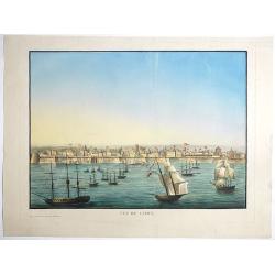
Vue de Cadix.
Very rare view of Cadiz and its seafront drawn and engraved by Renouard, published in Paris by Fatout et Avice, Quai Malaquais, 9. Beautifully hand colored at the time of...
- $2750 / ≈ €2374
Date: Paris, Fatout et Avice, Quai Malaquais 9 , c.1838
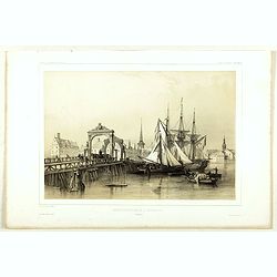
Pont de Knippelsbroe a Copenhague.
View of Knippelsbroe's bridge in Copenhagen. From "Voyage en Scandinavie, en Laponie, etc" - Atlas Pirtoresque (complément). Designed by A.Mayer.
Date: Paris, ca 1834-1838
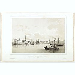
Stockholm, 2e vue en panorama, prise sur le Velar.
Lithography on tinted grounds. View of Stockholm. From "Voyage en Scandinavie, en Laponie, etc" - Atlas Pirtoresque (complément). Designed by A.Mayer and litho...
Date: Paris, ca 1834-1838

Carte du pays de Montenegro dressée d'après les opérations géodétiques . . .
Rare map of Montenegro prepared by Mr. le Comte Fedor de Karacsay (1787-1859) and engraved by Pietro Allodi. The title is in Russian, Arabic and French.In lower left corn...
Date: Vienna, ca. 1838
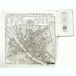
Guide de Florence et de ses environs Redige´ sur un plan entierement nouveau par l'Abbé A. Bulgarini et Traduit en français par A. Le Rendu. Deuxième édition.
Second edition. With 1 engr. folding plan (Pianta della Citta di Firenze. I. Balatri inc. e scris.) and 12 copper plates with views in Florence. The folding plan has meas...
- $550 / ≈ €475
Date: Florence, Gaspard Ricci, 1839
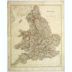
England.
A large and detailed steel engraved map of England, with each county divided by a different color. Many place names and physical features shown - it shows how densely pop...
Date: London, 1839
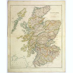
Scotland.
An attractive steel engraved map of Scotland, with each county divided by a different color. Many place names and physical features shown.The Arrowsmith family members we...
Date: London, 1839
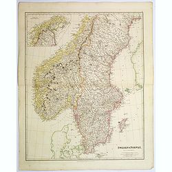
Sweden & Norway.
An attractive steel engraved map of Sweden & Norway. An inset map which is the continuation from Tornea to North Cape. Many place names and physical features shown.Th...
Date: London, 1839
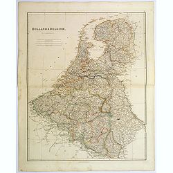
Holland & Belgium.
An attractive steel engraved map of Holland and Belgium. Map flanked by France and Prussia. Duchy of Luxembourg included. Many place names and physical features shown. 4 ...
Date: London, 1839
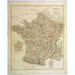
France.
A lovely, large steel engraved map of France, with an inset sketch of France divided into provinces, plus small inset map of the French Mediterranean island of Corsica . ...
Date: London, 1839
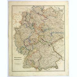
Western Germany.
A lovely, large steel engraved map of Western Germany. Some of the states engraved are: Holstein, Hannover, Mecklenburg, Saxony, Bavaria, Württemberg and Nassau. An extr...
Date: London, 1839
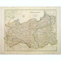
Prussia & Poland.
A glorious, large steel engraved map of Prussia and Poland. Some of the states covered are: Saxony, Pomerania, Posen, Brandenburg, Western & Eastern Prussia and the K...
Date: London, 1839
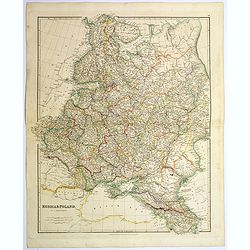
Russia & Poland.
A glorious, large steel engraved map of Russia and Poland. Covering Poland and Finland in the west, as far south as to the very edges of Persia, the Black sea, and to the...
Date: London, 1839