Browse Listings in Europe
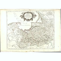
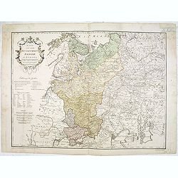
La Prusse divisée en Prusse Royale et Prusse Ducale.
The map extends from Memem, Danzig and Rosienne in the North to Novigrod in the southeast and Thorn on the Wessel in the southwest. Shows the Gulf of Danzig and part of P...
Date: Venice, 1776 - 1784
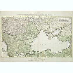
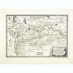
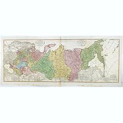
Carte de l'empire des Russies en Europe partie meridionale
Uncommon and detailed map of Ukraine.Published by Pierre Bourgoin in 1784 in his uncommon "Atlas Élémentaire de la Géographie", published at rue de la Harpe ...
- $350 / ≈ €302
Date: Paris, 1784
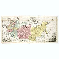
Tabula geographica generalis Imperii Russici ad normam novissimarum observationum astronomicarum concinnata. . .
Important three-sheet map of the Russian Empire under Catherine the Great. This map was first published in St Petersburg in 1775.Scale cartouche is decorated with a rocky...
- $2200 / ≈ €1899
Date: Augsburg, C.Lotter, c.1784
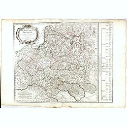
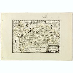
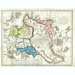
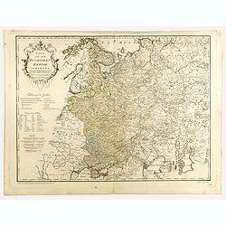
Royaume de Pologne.
Detailed map encompassing present-day Poland. The table provides a breakdown of the sub-regions of the Polish Crown.Venetian edition of the map by R. de Vaugondy, to whom...
- $350 / ≈ €302
Date: Venice, 1776 - 1784

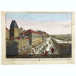
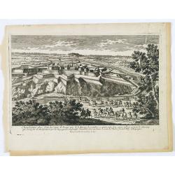
Plan de St. Jean de Luz avec les différents projets d'agrandissem.t du port.
Very rare and beautiful plan of the city and bay of Saint-Jean-de-Luz, detailing the projects of expansion of the port undertaken in 1780.The plan indicates the Artha Roc...
- $2200 / ≈ €1899
Date: Paris, 1784
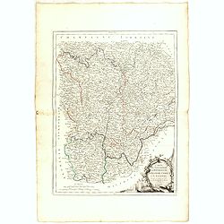
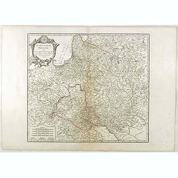
Gouvernements de Bourgogne, de Franche Comté et de Lyonnois.
Detailed map encompassing Bourgogne, Franche Comté and Lyonnois.Venetian edition of the map by Bonne, to whom Santini gives credit in the cartouche.From "Atlas Univ...
- $100 / ≈ €86
Date: Venice, 1776 - 1784

Carte De La Prusse Occidentale ou sont tracees les Provinces cedees Par la Pologne au Roi De Prusse . . . 1775
Finely and crisply engraved map of Western Prussia, now part of Poland on the Baltic Sea, including the Bay of Danzig. With ornamental title cartouche and noteworthy topo...
Date: Venice, 1776 - 1784
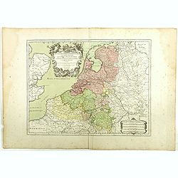
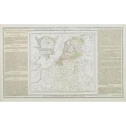
Les Dix-Sept Provinces des Pays-Bas. . .
Map of the present-day Benelux by L.C. Desnos. Engraved by Cordier.
- $100 / ≈ €86
Date: Paris, 1784
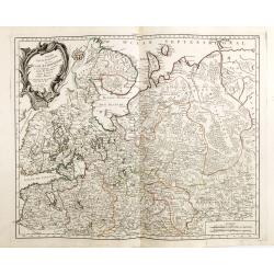
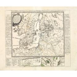
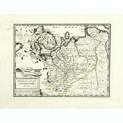
Partie Septentrionale de la Russie Europeenne ou sont distinguees exactement toutes les Provinces, d'apres le detail de l'Atlas Russien, Par le Sr. Robert de Vaugondy fils, Geog. Ordin? Du Roi.
Detailed map of northern European Russia, including Finland. The map was first published by the Venetian cartographer and publisher François (Père) Santini and first pu...
Date: Venice, 1784
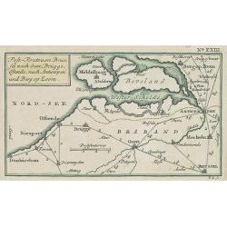
Post-Route von Brüssel nach Gent, Brügge, Ostende, nach Antwerpen und Bergen op Zoom. N°XXIII
Very rare post route maps map centered on Gent, and showing the postal routes in-between Oostende, Bruges, Gent, Brussels, Mechelen, Lier, Antwerp, Bergen op Zoom, etc. f...
- $250 / ≈ €216
Date: Nürnberg, Weigel and Schneider, ca.1785

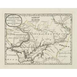
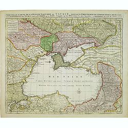
Carte de la Petite Tartarie Dresee par ordre de l'Imperatries de toutes las Russies.
The very rare first edition of De Leth's map of the southern part of Ukraine, with detailed annotations regarding the Cossacks and an explanatory key. Based on a Russian ...
- $1750 / ≈ €1511
Date: Amsterdam, ca. 1785
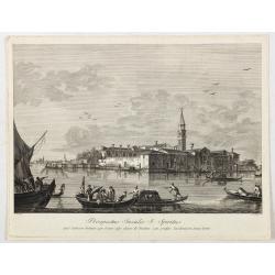
Prospectus Insulae S: Spiritus.
View depicting Burano after Francesco Tironi (Venise, 1745 - 1797), engraved by Antonio Sandi (1733 - 1817).The problems of Canaletto’s school and studio practice remai...
Date: Venice, c. 1785
![[Crimea]. Carte de la Cromée.](/uploads/cache/25719-250x250.jpg)
[Crimea]. Carte de la Cromée.
Mapmaker, Captain Jan Hendrik van Kinsbergen (1735-1819). Published by H. Friesman in 1787. This map first appeared in 1776 and was the first Russian map of the newly ann...
Date: Amsterdam, H. Frieseman, 1787
Carte de la Marche, du Bourbonnois, de Limousin, et de l'Auvergne.
Very fine map of Auvergne, Limousin, Bourbonnois and Marche regions in France. Engraved by Ballet and included in the rare atlas "Atlas Universelle" by Philippe...
- $150 / ≈ €129
Date: Paris, 1787
L'Allemagne dressée sur les observations. . .
Map of Germany, Low Countries, Poland, Switzerland, Northern Italy. Prepared by G.De L'Isle after observations by Kepler and Tycho Brahe.Engraved by Jean Batiste Liébaux...
- $300 / ≈ €259
Date: Paris, 1788
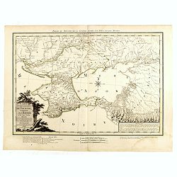
Carte du Gouvernement de Tauride, comprenant la Krimée et les pays voisins: dressée principalement d'après la carte faite sur les lieux pour le voyage de S.M. l'impératrice de Russie. . .
Very rare map of the Crimea area published Jean-Claude Dezauche, who was active in Paris 1770-1824. The map includes borders and a road system.Dezauche is giving credit t...
- $850 / ≈ €734
Date: Paris, 1788
Kriegstheater oder Graenzkarte Oesterreichs, Russlands, und der Türkey. . .
Map of the theatre of war in the Balkans, Ukraine and around the Black Sea, indicating the Austrian, Russian and Turkish spheres of influence. Printed on two sheets and j...
Date: Artaria und Compagnie, Vienna, 1788

Tableau des guerres de Frédéric le Grand: ou plans figurés de vingt-six batailles rangées, ou combats essentiels donnés dans les trois guerres de Silésie. . .
The book includes a large folded map "Tableaux des Guerres de Frédéric le Grand", showing a map of Prussia, with present-day Poland and Eastern Germany surrou...
Date: Potzdam, Strasbourg, Paris, 1788
![Matelot Hollandais [Dutch sailor]](/uploads/cache/28927-250x250.jpg)
Matelot Hollandais [Dutch sailor]
Etching showing a typical Dutch sailor, after Jacques Grasset de Saint-Sauveur (1757–1810). Taken from "Costumes Civils actuels de tous les peuples connus, dessin�...
Date: Paris, Pavard, 1788
![[Manuscript] Plan du siege de la forteresse d'Oczakow avec les détails... aux ordres du Prince Potemkin, le 17 Decemb: 1788.](/uploads/cache/34599-250x250.jpg)
[Manuscript] Plan du siege de la forteresse d'Oczakow avec les détails... aux ordres du Prince Potemkin, le 17 Decemb: 1788.
Very detailed well executed manuscript plan of the Turkish Fortress Ochakov captured by Russian Troops on December 17, 1788 by the Maréchal Prince Potemkin. In lower lef...
- $2000 / ≈ €1726
Date: ca. 1788
Carte du Gouvernement de Tauride, comprenant la Krimée et les pays voisins: dressée principalement d'après la carte faite sur les lieux pour le voyage de S.M. l'impératrice de Russie. . .
Rare map of southern Ukraine and the Crimea during the Second Russo-Turkish War (1787-92). Antique map of the Crimea during the Second Russo-Turkish War (1787-92), fought...
- $2500 / ≈ €2158
Date: Paris, 1788

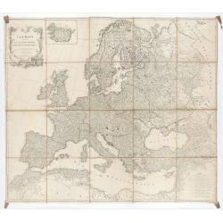
Carte d'Europe divisée en ses Empires et Royaumes.
Uncommon and decorative wall map of Europe, prepared by Clouet. Superb decoration including a wonderful rococo border with vignettes describing historical scenes. Below t...
Date: Paris, Mondhare, 1788

Femme Samoyeds.
Originally hand-colored mezzotint from 'Costumes civils actuels de tous les peuples connus', showing a woman and child from Samojedin, Siberia in Russia. Engraved after J...
- $30 / ≈ €26
Date: M. Sylvain Maréchal. Paris, 1788

Fille de Barabinze.
Originally hand-colored mezzotint from 'Costumes civils actuels de tous les peuples connus', showing a girl from Barabinze in Siberia, Russia engraved by Félix Mixelle a...
- $30 / ≈ €26
Date: M. Sylvain Maréchal. Paris, 1788
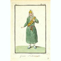
Femme Tschouwache.
Originally hand-colored mezzotint from 'Costumes civils actuels de tous les peuples connus' engraved by Félix Mixelle and Lachaussée Jeune after Jacques Grasset de Sain...
- $30 / ≈ €26
Date: M. Sylvain Maréchal. Paris, 1788
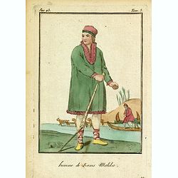
Homme de Kams Malika.
Originally hand-colored mezzotint from 'Costumes civils actuels de tous les peuples connus'. Showing a man from Russia, by M. Sylvain Maréchal. Paris, 1788.As an etcher,...
- $25 / ≈ €22
Date: M. Sylvain Maréchal. Paris, 1788
Neue Karte von den gegenwärtigen Kriegs-Schauplatze zwischen den Russisch-Kayserl.
Very rare separately published map showing the Russian War seat including Finland, Lithuania, Denmark and parts of Poland, Norway and Sweden. In lower part inset maps of ...
Date: Leipzig, 1788
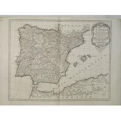
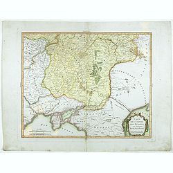
Carte de l'Espagne Dressée par Guillaume Delisle sur la description de Rodrigo Mendez Sylva . . .. Le tout augmenté et vérifié en 1789. Par Phil. Buache, de l'Académie des Sciences.
Map of Spain published at the outbreak of the French Revolution. Taken from the Atlas Géographique.. published by Dezauche, as successors to De l'Isle & Buache. Publ...
Date: Paris, 1789
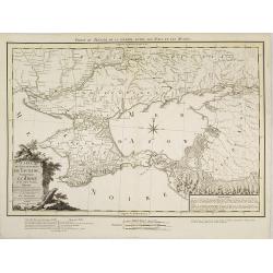
Des Russischen Reiches Statthalterschaften Neurussland, Asow, und das Oestliche Nogay
Map showing Lake Asow and the Crimea. The river Dnepr until Krementschug, and the river Don until Pawlowsk. Published by Franz Johann Joseph von Reilly.
Date: Vienna, 1789
Geographische General Karte Der Gränzen zwischen denen dreyen Kaiserthümern und ihren nach und nach geschehenen Veränderungen vom Jahr 1718 bis heutigen Tags. . .
Detailed map of present-day Bulgaria, which is carved into the Ottoman provinces of Bulgaria, Macedonia, and Romania (Rumelia), the Crimea and the Black Sea. Prepared by ...
- $1250 / ≈ €1079
Date: Vienna, 1788-1789
Des Russischen Reiches Statthalterschaften Pleskow, Polozk, Mohilew, Twer, Moskau, Koluga, Wolodimer, Iaroslaw, Tula, Smo, Lensko und Nischgorod. Nro.64
Map of the European part of Russia, centered on Moscow. Published by Franz Johann Joseph von Reilly, 1766-1820, who was a Viennese art dealer who turned to map publishing...
- $150 / ≈ €129
Date: Vienna, 1789
Des Russischen Reiches Statthalterschaft Archangel Nro.66
Map of the North Western part of Russia. Published by Franz Johann Joseph von Reilly, 1766-1820, who was a Viennese art dealer who turned to map publishing in his early t...
- $150 / ≈ €129
Date: Vienna, 1789
Des Russischen Reiches Statthalterschaften Pleskow, Polozk, Mohilew, Twer, Moskau, Koluga, Wolodimer, Iaroslaw, Tula, Smo, Lensko und Nischgorod. Nro.64
Map of the European part of Russia, centered on Moscow. Published by Franz Johann Joseph von Reilly, 1766-1820, who was a Viennese art dealer who turned to map publishing...
- $150 / ≈ €129
Date: Vienna, 1789
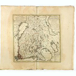
MAGNI PRINCIPATUS, ceu Provinciae REGNI SUECIAE, FINNLANDIAE Mappa generalis geographica : ex HASIANIS aliisque certissimis subsidiis, in suas Provincias minores sive speciales, tanquam statum politicum modernum . . .
A large and rarely seen map of Finland prepared by Haas. Extends from St. Petersburg north to well above the Gulf of Bothnia.
- $700 / ≈ €604
Date: Nuremberg, 1789
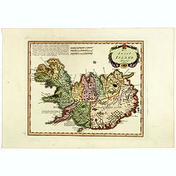
Die Insel Island Nro. 76.
An attractive map of Iceland based on the unpublished Knoff survey. The map locates villages and churches and graphically delineates the mountains, rivers, lakes and fore...
- $600 / ≈ €518
Date: Vienna, 1789
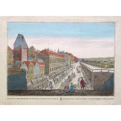
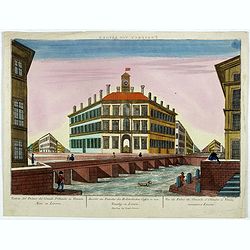
Prospectus primarii.. turrim rubram Viennae.
So-called optical print, showing Red tower in Vienna.In the eighteenth and nineteenth centuries there were many popular speciality establishments in Paris, Augsburg and L...
- $175 / ≈ €151
Date: Italy c.1790
Les Pays Bas François, Autrichiens, et Hollandois..
Finely engraved map centered on the Netherlands, extending to include Belgium and Luxembourg.Finely embellished with a large title cartouche surmounted by Mercury's head....
Date: Paris, 1790
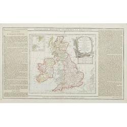
Les Isles Britanniques..
An attractive map of the British Isles including an inset of the Orkney and Shetland Islands. Finely embellished with a large title cartouche.The map is flanked by two co...
- $90 / ≈ €78
Date: Paris, 1790
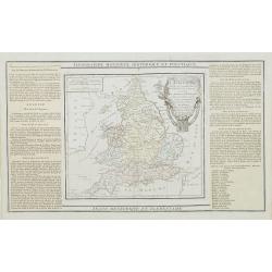
L'Angleterre divisée en 5 grandes Parties. . .
A very attractive map of England and Wales showing its 52 counties and the major cities as well as five large regional divisions.Finely embellished with a large title car...
- $100 / ≈ €86
Date: Paris, 1790
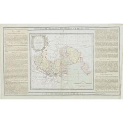
L'Etat de Venise et le Duché de Mantoue..
Attractive map covering the region centered on today region Veneto and its chief town Venice.Extending westwards to include part of Lombardy and eastward to Trieste and I...
- $100 / ≈ €86
Date: Paris, 1790
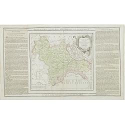
Partie de l' Italie, comprenant les Etats du Roy de Sardaigne. . .
Decorative map of northwest Italy and the Golfo di Genova. With ornamental title cartouche.Flanked by two columns of French text containing geographical information about...
- $100 / ≈ €86
Date: Paris, 1790
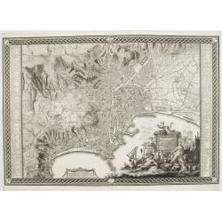
Planta della citta di Napoli come esifte nel prefeute Anno MDCCXC.
This stunning large-scale plan of Naples was prepared by Rizzi-Zannoni and engraved by Giuseppe Guerra from Naples. To the right and left a key to the important places of...
Date: Naples, 1790

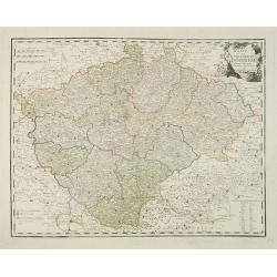
Le Royaume de Boheme, le Duché de Silesie, et les Marquisats de Moravie et Lusace, dresses d'apres les cartes de Muller . .
Map of Poland, Bohemia, Silesia, Moravia and Lusatia. Large decorative title cartouche in upper right. In upper left corner inset plan of Breslau and in lower right a ins...
Date: Paris, 1790
Prospectus primarii telonii caesarei prope turrim rubram Viennae. . .
So-called optical print, showing Red tower in Vienna.In the eighteenth and nineteenth centuries there were many popular specialty establishments in Paris, Augsburg and Lo...
- $80 / ≈ €69
Date: Italy c.1790
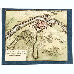
(Manuscript map of Narva und Ivangorod.)
An early manuscript very finely executed watercolor town-plan of the town of Narva, located at the eastern tip of Estonia, on the Russian border.With a key in lower left ...
- $1000 / ≈ €863
Date: Germany?, c. 1790
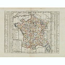
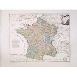
La France divisée en 83 départemens suivant les décréts de l'Assemblée Nationale, sanctionnés per le Roi. . .
An interesting folding map of France divided in 83 departments, to the right the 83 departments added on past-on slips. Another past-on is advertising Desnos' atlas in la...
Date: Paris, 1790
Prospect von Livorn. - Venduta del Palazo del Console D'Olanda in Venezia Nova in Livorne.
So called optical print published by Joseph Carmine showing the home of the Dutch consul in Livorno. Engraved after a design of Antonio Piemontesi. A well-known publisher...
- $100 / ≈ €86
Date: Augsburg, ca. 1790
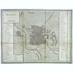
Madrid.
Plan of Madrid, by Tardieu. With numbered key (1-74) of the main buildings and buildings of the city. Table with translations of Spanish words in the right bottom.
- $150 / ≈ €129
Date: Paris?, ca. 1790
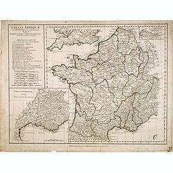
Gallia Antiquae. . .
A fine map of ancient France.
Date: London, 1790

Turquie Européenne, Avec les Pays limitrophes. . .
Copper engraved map centered on Greece, extending northwards and eastwards to include the Balkans and Ukraine as well as Cyprus.The map is flanked by two columns of Frenc...
- $50 / ≈ €43
Date: Paris, 1790
Des Hochstifts Luttich..
Uncommon map covering the area of Limburg in present day Belgium. Also including western borderline of the Dutch province of Limburg.
Date: Vienna, 1791
L'alta Lombardia, Terzo Foglio Che comprende parte degli Stati del Re di Sardegna e parte della Repubblica di Genova.
Interesting map covering the border between France and Italy. In Nuovo Atlante Geografico Universale.
- $200 / ≈ €173
Date: Rome, 1791
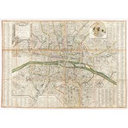
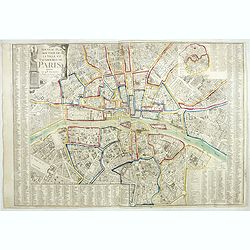
Nouveau plan routier de la ville et faubourgs de Paris. 1791
Plan quadrillé en segments, entoilé. De part et d'autre "Table alphabétique des rues". Plan mis à jour auquel on a ajouté dans un cartouche en bas : un pla...
Date: Paris, 1791

Prospectus novi Circi pro Nundinis in Solemnitate Ascensionis Venetiis in Foro maximo.
After a painting by Francesco Guardi, preserved at the Kunsthistorisches Museum, Vienna, the engraving depicts the wooden scenographic structure created in 1776 by Maccar...
Date: Venice, after 1791
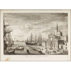
S. Georgii Majoris Ecclesiae prospectus.
S. Georgii Majoris Ecclesiae prospectus". S. Giorgio with the church and quay in sharp perspective.From the series "Prospectum Urbis Venetiarum" (Views of ...
Date: Venice, ca. 1791
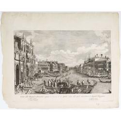
Veduta della Magnifica REGATA seguita in Venezia li 2. Aprile 1791 alla quale intervennero li Augusti Viaggiator.
Decorative engraving of a Venice regatta on the Grand Canal, by Teodoro Viero (1740-1819) after a paining by Canaletto.The tradition of Venetian origin of the race is lin...
Date: Venice, c. 1791
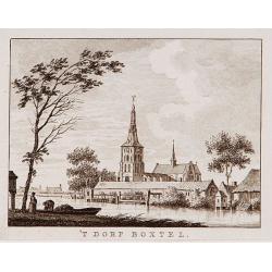
't dorp Boxtel.
Rare print of a view on the town of Boxtel (near Eindhoven), from Vaderlandsche gezichten of afbeeldingen.. by J.Bulthuis, printed by H.Gartman in Amsterdam.
- $150 / ≈ €129
Date: Amsterdam, 1786-1792

't dorp Aalst.
Rare print of the old church of Aalst (near Eindhoven), from Vaderlandsche gezichten of afbeeldingen.. by J.Bulthuis, printed by H.Gartman in Amsterdam.
Date: Amsterdam 1786-1792
Charleroy place forte du Comte de Namur pres de la Riviere de Sambre. . .
A very decorative and extremely rare town-view of Charleroi. Engraved by Pierre-Alexandre Aveline. With "fait par Aveline avec privilege du Roy" in lower margin...
Date: Paris, ca.1792

Il Governo di Guascogna con porzione del Governo di Guienna.
Rare regional map of France of the Périgord, Guienne, Gascogne and the Béarn published by Carli Pazzini in Siena.
Date: Siena, 1792
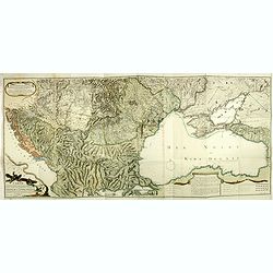
Nouvelle Carte de la Petite Tartarie et la Mer Noire, montrant les Frontieres de l'Impératrice de Russie et de l'Empereur des Turcs, tant en Europe qu'en Asie, Dessigné selon la proposition de G. De L'Isle et d'autres Auteurs.
Shows Ukraine and the Black Sea in a fine impression with original 18th-c. hand-coloring. Elwe published an atlas in 1792, mainly using the copperplates of Joachim Ottens...
- $500 / ≈ €432
Date: Amsterdam, 1792

't dorp Aalst.
Rare print of the old church of Aalst (near Eindhoven), from Vaderlandsche gezichten of afbeeldingen.. by J.Bulthuis, printed by H.Gartman in Amsterdam.
Date: Amsterdam, 1786 / 1792
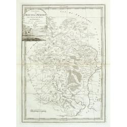
La France Divisée en IX Régions, 10 Métropoles, et 85 Départements ..
Scarce map of France prepared after J.B.Nolin and published by Mondhare for his Atlas Général a l'usage des colleges et maisons d'education.. Lower right inset map of C...
- $60 / ≈ €52
Date: Paris, 1793
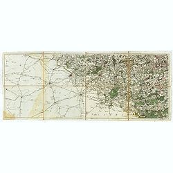
Les environs de Mons, Beaumont, Chimay, Valenciennes, Condé, &c.
Detailed map of Northern France, centered on Valenciennes and Mons. The map was prepared by Jean Baptiste de Bouge (1757-1833), who prepared one of the first very detaile...
- $50 / ≈ €43
Date: Bruxelles 1789 - 1793
Nouveau plan routier de la ville de Paris.
Detailed plan of Paris. There is a street index down both margins and a list of theatres and public libraries. The plan now shows Place de la Révolution, Place des Pique...
- $1000 / ≈ €863
Date: Paris, 1793
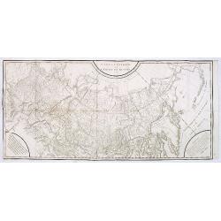
Carte générale de l'empire de Russie.
Map of Russia. Map from a second French edition of Peter Simon Pallas' Voyages du Professeur Pallas, dans Plusieurs Provinces de l’Empire de Russie et dans l’Asie Sep...
Date: Paris, Maradan, 1794
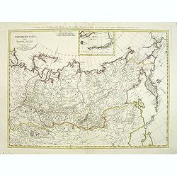
Imperii Russici Pars Orientem Spectans Tab. II da. ex optimis subsidiis delineata a. C. Mannert Norimberge Prostat in Officina A. G. Schneideriana. . .
The Russian empire eastward from the Dvina River, indicating some unexplored coastlines in Nova Zemlya and northeastern Siberia. Includes an inset with a portion of Alask...
Date: Nurernberg, 1794
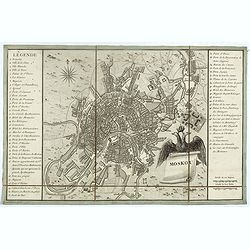
Moskou.
Charming little town-plan of Moscow engraved by Tardieu. Separately issued and also included in "l’Histoire de la Russie" by Leclerc. This plan is decorated w...
- $750 / ≈ €647
Date: Paris, 1794
The European Part of the Russian Empire . . .
Highly detailed map of the Russian Empire at the end of the 18th Century, by William Faden.The map is a significant advance from the earlier maps by Kitchin, Sayer and Je...
- $800 / ≈ €691
Date: London, 1794
L'Europe divisée en des Etats, Empires, Royaumes et Républiques.
Large wall map of Europe with inset map of Iceland and cartouche drawn and etched by Arrivet. Revised edition by Charles François Delamarche (1st ed.: 1767), entitled &q...
Date: Paris, (n.d.) c. 1793/1794
Karte von Frankreich.
An attractive oversized map of France. With a decorative title cartouche in the upper right-hand corner and a legend on the left side. Engraved by Ant.Amon.Franz Johann J...
Date: Vienna, 1795
I Governi Di Moscovia E Woronez Nell' Impero Della Russia In Europa . . .
Rare and highly decorative regional map of Russia. The map is centered on Moscow and covers the region bounded by the course of the Volga River from north of Romanow to t...
- $350 / ≈ €302
Date: Rome, 1795
Carte générale de la Pologne : avec ses différens démembremence par les puissances partageantes en 1773 et 1795 / dessinée et dressée par Mariaval. . .
Very rare map of Poland, engraved by Tardieu l’Ainé, active at rue de Sorbonne 385.
Date: Paris, ca. 1795
Karte von dem Konigreiche Boheim.
An attractive map of Bohemia. With a nice title cartouche decorated with cherubs in the upper right-hand corner. Engraved by Kil. Ponheimer.Franz Johann Josef von Reilly ...
- $300 / ≈ €259
Date: Vienna, 1796
I Governi di Olonechoi, Carella, Bielozero, e'd Ingria nell Impero della Russia in Europa con la Lapponia Russa. . .
An uncommon map of Finland, Lapland and part of Russia with highly decorative title cartouche. From 'Nuovo Atlante Geografico Universale'.
Date: Rome, 1796
Il governo di arcangelo nell' impero della russia diviso. . .
Detailed map of the northern part of the Russian Empire with a decorative title cartouche. In the upper left corner part of the Baltic Sea with Lapland. Published in the ...
Date: Rome, 1795-1796
Karte von dem Russischen Reiche in Europa . . .
An attractive map of European Russia. Very detailed with rivers lakes mountains etc. Russia with a decorative title cartouche in the upper left-hand corner. Engraved by F...
- $650 / ≈ €561
Date: Vienna, 1796
Karte von dem Russischen Reiche in Europa . . .
An attractive large map of European Russia, including Finland. Very detailed with rivers lakes mountains etc. Russia with a decorative title cartouche in the upper left-h...
- $650 / ≈ €561
Date: Vienna, 1796
Le Royaume De Pologne, divise selon les Partages faits en 1772, 1793 et 1795, etnre la Russie, la Prusse et l'Autriche . . .
The uncommon later edition of this detailed map of Poland, showing the lands lost to Russia, Prussia and Austria in 1772, 1793 and 1795. with a color key added underneath...
Date: Paris, ca. 1796
Karte von Polen.
An attractive map of Poland. With a decorative title cartouche in the upper left-hand corner. Engraved by Ant. Amon. Franz Johann Josef von Reilly (Vienna 18 august 1766 ...
- $950 / ≈ €820
Date: Vienna, 1796