Featured Listings in Recent acquisitions
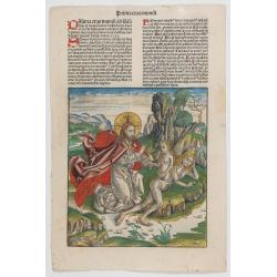
Prima Etas Mundi. VI
A very fine presentation of Eve, being created by God from Adam’s side.Page from the richest illustrated Incunable, the famous: Nuremberg Chronicle, published the year th...
Date: Nuremberg, 12 July 1493
![[Sea monsters] De regni Settentrionali Monstri marini & terrestri…](/uploads/cache/49169-250x250.jpg)
[Sea monsters] De regni Settentrionali Monstri marini & terrestri…
Münster's plate of monsters of both land and sea, taken from an Italian text edition of Münster's Cosmographia, which is a short and complete summary of Renaissance knowl...
Date: Basel, 1558
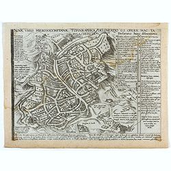
Novae Urbis Hierosolymitanae topographica delineatio . . .
A very rare plan of modern Jerusalem oriented to the east, according to a note on the map the map was drawn after a map by Peter Laicstain. A lettered key to the right.Up...
Date: Antwerp, 1571
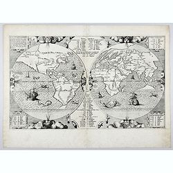
Benedict. Arias Montanus Sacrae Geographiae Tabulam Ex Antiq
THE EXTREMELY RARE FIRST STATE landmark world map, famed for its depiction of the Australian landmass.One of the earliest printed maps to depict the “terra incognita” of...
Date: Anvers 1571 /1572
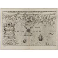
De Zee-Kuste vant Landt te Noort-oosten sorterende onder Norweghen ende eendeels onder Sweden alsoe tlandt aldaer in zijn gedaente is, van Distelberch tot Waersberghe.
A rare Latin text edition of this early and detailed chart of the coast of Norway of this landmark contribution to the science of navigation. Decorated by a large title c...
Date: Leiden, Plantijn, 1585
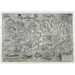
Islandia.
1603 ORTELIUS, A. - Perhaps the most famous map of Iceland. On the south side of the island, a collection of all possible sea monsters is depicted. Polar bears on ice flo...
Date: Antwerp, 1603
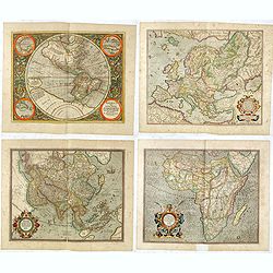
Set of four continents.
Fine set of 4 continents prepared by Gerard Mercator. The general map of Europe, as well as Americae Pars, Greenland, Iceland, a Polar landmass, along with the mythical i...
Date: Amsterdam, 1628
![(Chatelain "Atlas Historique" in 7 volumes.]](/uploads/cache/47053X-250x250.jpg)
(Chatelain "Atlas Historique" in 7 volumes.]
Henri Abraham Chatelain, whose Atlas Historique was one of the most expansive encyclopedias of the age. First published in 1705, Chatelain's Atlas Historique was part o...
Date: Amsterdam: Chez Zacharie Châtelain, 1732 - 1739
![[Manuscript chart on vellum of the Java Sea]](/uploads/cache/33613-250x250.jpg)
[Manuscript chart on vellum of the Java Sea]
One of the few manuscript charts on vellum in private hands, signed by Isaac de Graaf. ORIGINAL MANUSCRIPT MAP IN RED, GREEN AND BLACK INK showing the Java Sea centered o...
Date: Amsterdam, 1743

Carta Topografica dell' Isola Del Maritaggio di Monsieur le Boble per la prima volta. Tradotta dal francese in italiano.
Second Italian printing of Eustache Le Noble’s "Carte de l’isle de marriage." The book’s text offers instructions on how to reach this matrimonial island and de...
Date: Cosmopoli, 1766
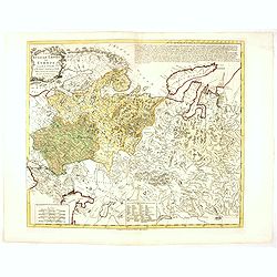
Russian Empire in Europe from the Dr. D'Anville of the Royal Academy. . .
Rare map of Russia, prepared by John Bayly (active 1755-1794) after D'Anville. In the lower-left corner parts of the Caspian and Black Sea. In the upper right corner Nova...
Date: London, ca. 1782
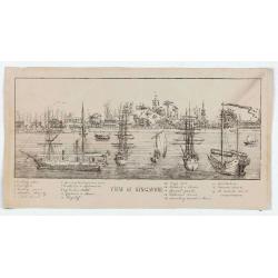
View of Singapore
Very rare view of Singapore from the Singapore River Basin. With a numbered key (1-19) underneath the illustration. In the center Government Hill with Governer's House (1...
Date: ca. 1850
Volume III of the monumental atlas, ‘L’Orbe Cattolico ossia Atlante Geografico Storico Ecclesiastico’.
PETRI Girolamo's extremely rare Atlas volume III of the monumental atlas, ‘L’Orbe Cattolico ossia Atlante Geografico Storico Ecclesiastico’, respectively depicting eccl...
Date: Rome, 1858
![[Lot of 9 maps] Plan général de Sébastopol avec indication des travaux du siege et de la defense au 28 mars - 9 avril 1855. Feuille 10. xiii](/uploads/cache/33907-250x250.jpg)
[Lot of 9 maps] Plan général de Sébastopol avec indication des travaux du siege et de la defense au 28 mars - 9 avril 1855. Feuille 10. xiii
A group of nine (of 14) very rare panoramic town-plans of the siege of Sebastopol or maps of the Crimea. In lower margin : "Gravé au Dépôt topographique de la Guerre...
Date: St. Petersburg, N. Thieblin, 1863

Mapa Polski i Krajów Osciennych - Wydanie trzecie. Opracowal Stanislaw Max. Wydani M. Arcta.
‘The Birth of Modern Poland on a map’ - an excellent wall map of Poland and surrounding regions, published in Warsaw near the end of World War I, when Poland’s fate was u...
Date: Warsaw, [H. Sklodowski], 1918
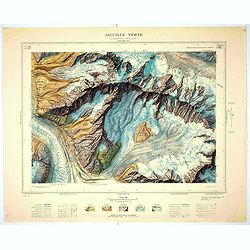
Aiguille verte - Chamonix N°6 Sud
Magnificent 1:10,000 scale color printed map of l'Aiguille verte (Chamonix N°6 Sud) based on stereotopographic ground and aerial surveys carried out in the field in 1950 ...
Date: Paris, 1953
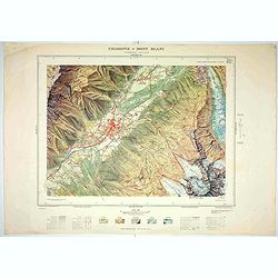
Chamonix - Mont Blanc - Chamonix N°5 Sud.
Magnificent 1:10,000 scale color printed map of Chamonix - Mont Blanc (Chamonix N°5 Sud) based on stereotopographic ground and aerial surveys carried out in the field in ...
Date: Paris, 1953
![[A collection of 100 Soviet propaganda poster published in the 1980's]](/uploads/cache/47076-250x250.jpg)
[A collection of 100 Soviet propaganda poster published in the 1980's]
A collection of 100 Soviet propaganda posters published during the early years of the Perestroika & Glasnost period. Most posters are made by Plakat (All-Union Poster...
Date: Moscow, ca. 1980-1989
