Browse Listings in Asia > South East Asia > Java / Bali > maps

Iava Maior.
Very fine miniature map of Java, engraved by Benjamin Wright (1575-1613). This early map contains detailed geography and nomenclature around the northern coastline of the...
Date: Amsterdam, Cornelis Claes, 1606
![[Bantam].](/uploads/cache/37970-250x250.jpg)
[Bantam].
Text engravings from "Premier livre de l'histoire de la navigation aux Indes Orientales, par les hollandois, et des choses a eux advenues . . . ", being the cla...
Date: Amsterdam, Cornille Nicolas, 1609

Carte de l'Ile de Java.
An inset plan of Batavia and clearly indicated rice fields, mountains, forests, towns in profile and even elephants suggest the wealth of detail found on this map. Modele...
Date: Amsterdam, 1720

Kaart van een gedeelte van de Noord Kust van Java en Straat Sunda van Tanjong Kaik tot den vierden hoek bij Anjer..
Very large and rare chart depicting Java's northern seacoast.Coastal profiles are present at the bottom of the map.The chart is prepared by B.H.Staring, J.A.G.Rietveld an...
Date: Amsterdam 1843-1844

Straat Sunda en Westkust van Java.
Very large and rare chart depicting Java's western seacoast close to the Sunda Strait.Showing part of Sumatra on top and the West Java tip, today hosting the Ujung Kulon ...
Date: Amsterdam (1841)1846

Kaart van de Reede van Batavia met de verschillende vaarwaters naar dezelve trigometrisch opgenomen op last van deb schout bijnacht E.Lucas.
Very large and rare so-called blue-black chart centered on Jakarta's harbor.The chart is prepared by B.G.Escher, I.A.C. Eschauzier, B.H.Staring and E.H.Boom during an exp...
Date: Amsterdam (1841) 1847

Kaart der Moluksche eilanden en vaarwateren … F.A.A. Gregory Luitenant ter zee …
Huge sailing chart centered on the Moluccas Islands. Published by Widow Gerard Hulst van Keulen.The publishing house van Keulen, were the most prominent chart makers at ...
Date: Amsterdam, 1847
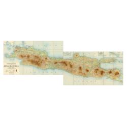
Overzichtskaart van Java en Madoera schaal 1:500.000. Met aanduiding van de politieke indeeling, de organisatie van het bestuur, de bestaande en nog aan te leggen verkeerswegen en van de groote cultuur- en industrieele centra…
If assembled a very large color-printed map (60x 218cm.) of Java and Madoera (Madura Island) on four sheets, each measuring 60 x 54.5 cm, dissected into 12 sections and l...
Date: Atelier Kurkdjian-Soerabaia, 1912
