Please login to see price!.
Subscribe to be notified if similar examples become available.
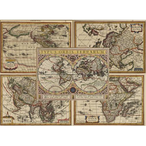
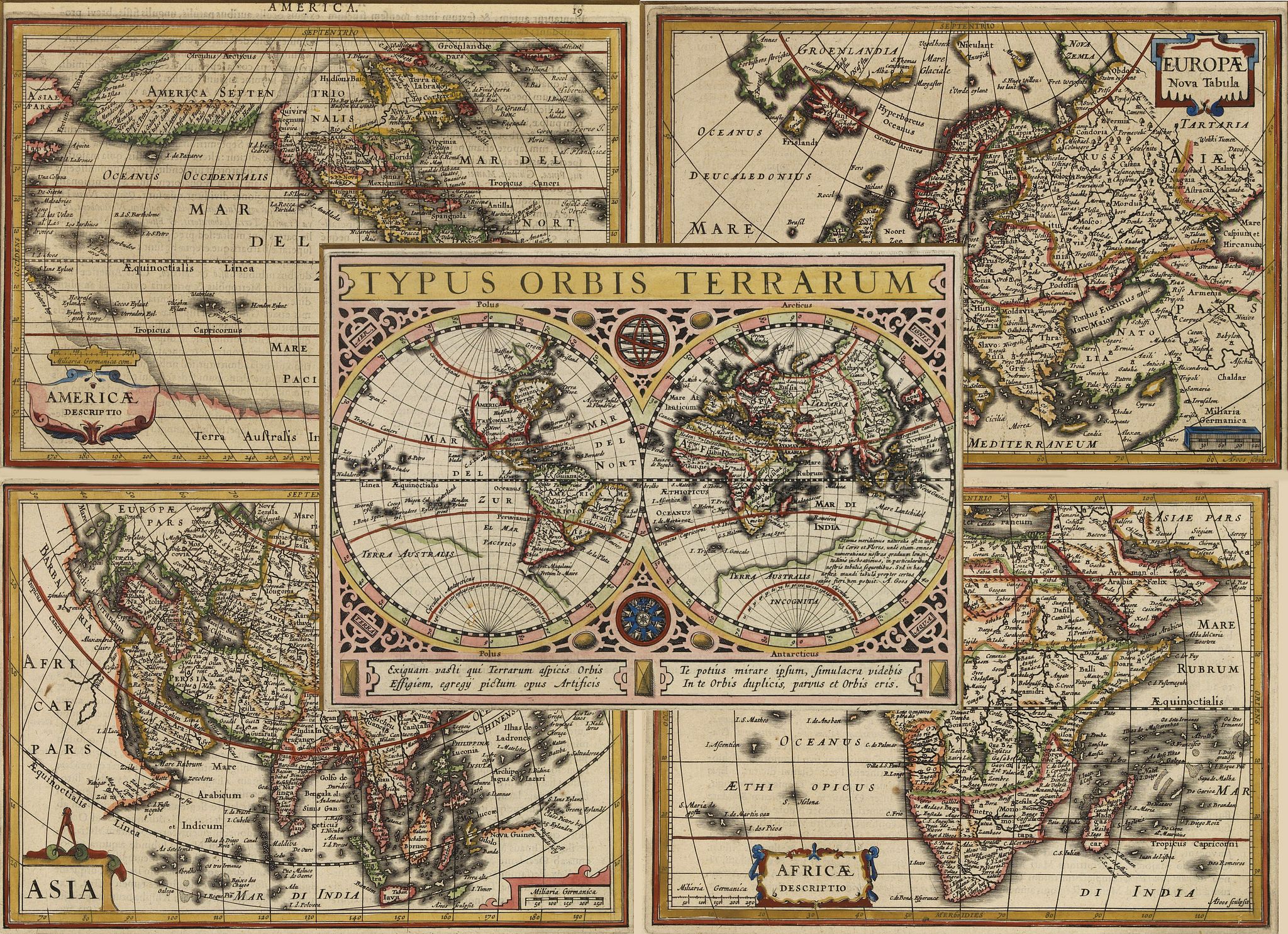
[World and Four Continents]. |
||||||||||||||||||||
|
||||||||||||||||||||
|
|
||||||||||||||||||||
|
Selling price: $...
Please login to see price! Sold in 2020 Missed this item! Be the first to get notified about our newly added listings. Add your name to our mailing list. Feel free to contact us if you have a question about this item. |
Virtual Collection - Save and collect this or any of your favorite items in one place.
If you want to save the items permanently, please sign in or create account first. |
|||||||||||||||||||
Description
A beautiful set of maps engraved by Goos of the World and four continents. The first map is the striking World double hemisphere map.
This map is from Jan Janssonius pocket-size " Atlas Minor".
California is shown as an island, and there are remnants of the unknown southern continent, "Terra Australis Incognita", which remains, with an elaborate explanation of the region where Australia would later appear.
It includes an elaborate strapwork border, two notes in Latin, an elaborate compass rose and sphere, references to the 4 elements in the corners (air, fire, earth and water) and other embellishments.
The second map is a fine small map of Africa. There are many places named and rivers noted, including Madagascar and many small Indian Ocean islands. It is decorated with a delicate title cartouche.
The third map is Americae Descriptio. The most dominant feature of the map is the curious depiction of the west coast of North America, which is completely bisected by an unnamed straight (Northwest Passage), possibly derived from reports of Juan de Fuca's disputed voyage. The bulging northwest coast of North America continues another 65 degrees and is separated from Asia by a narrow Fretum Anian.
These features were derived from the Van den Keere and Plancius globe of 1614 and this is the first time they appear on a map of the Americas. Previous maps had depicted the supposed Northwest Passage through the Strait of Anian. Other interesting features include the St. Lawrence River flowing from a small lake in the west, no Great Lakes, and an area of shading in Virginia alluding to the possibility of a Verrazano-type inland sea.
The fourth map is that of Asia. Although engraved by Goos, it strongly resembles Pieter van den Keere's configuration with Japan on the Teixeira model and the island of Korea, here called Cory. Van den Keere engraved many of the other maps in Jansson's Atlas Minor.
The fifth and final map is of Europae Nova Tabula. It shows the discoveries of Willem Barents in his quest to find a Northeast Passage to Asia.
Reference: Koeman, Me.194 Shirley 355 Burden 221,
FAQ - Guarantee - Shipping
Buying in the BuyNow Gallery
This item is available for immediate purchase when a "Add to Cart" or "Inquire Now" button is shown.
Items are sold in the EU margin scheme
Payments are accepted in Euros or US Dollars.
Authenticity Guarantee
 We provide professional descriptions, condition report (based on 45 years experience in the map business)
Paulus Swaen warrants the authenticity of our items and a certificate of authenticity is provided for each acquired lot.
Condition and Coloring
We indicate the condition of each item and use our unnique HiBCoR grading system in which four key items determine a map's value: Historical Importance, Beauty, Condition/Coloring and Rarity.
Color Key
We offer many maps in their original black and white condition. We do not systematically color-up maps to make them more sellable to the general public or buyer.
Copper engraved or wood block maps are always hand colored. Maps were initially colored for aesthetic reasons and to improve readability. Nowadays, it is becoming a challenge to find maps in their original colors and are therefor more valuable.
We use the following color keys in our catalog:
Original colors; mean that the colors have been applied around the time the map was issued.
Original o/l colors; means the map has only the borders colored at the time of publication.
Colored; If the colors are applied recently or at the end of the 20th century.
Read more about coloring of maps [+]
Shipping fee
A flat shipping fee of $ 30 is added to each shipment by DHL within Europe and North America. This covers : International Priority shipping, Packing and Insurance (up to the invoice amount).
Shipments to Asia are $ 40 and rest of the world $50
We charge only one shipping fee when you have been successful on multiple items or when you want to combine gallery and auction purchases.
Read more about invoicing and shipping
FAQ
Please have a look for more information about buying in the BuyNow gallery
Many answers are likely to find in the general help section.
Virtual Collection
![]()
With Virtual Collection you can collect all your favorite items in one place. It is free, and anyone can create his or her Virtual map collection.
Unless you are logged in, the item is only saved for this session. You have to be registed and logged-in if you want to save this item permanently to your Virtual Collection.
Read More[+]
Register here, it is free and you do not need a credit card.
Add this item to
Virtual Collection
or click the following link to see my Virtual Collection.
| Digital Image Download | |
|
Paulus Swaen maintains an archive of most of our high-resolution rare maps, prints, posters and medieval manuscript scans. We make them freely available for download and study. Read more about free image download |
Click the image for a free small image download. |
![Rare, antique map of [World and Four Continents].](/uploads/42468.jpg)
In accordance with the EU Consumer Rights Directive and habitually reside in the European Union you have the right to cancel the contract for the purchase of a lot, without giving any reason.
The cancellation period will expire 14 calendar days from the day after the date on which you or a third party (other than the carrier and indicated by you) acquires, physical possession of the lot. To exercise the right to cancel you must inform Paulus Swaen Inc, of your decision to cancel this contract by a clear statement (e.g. a letter sent by post, or e-mail (amsterdam@swaen.com).
To meet the cancellation deadline, it is sufficient for you to send your communication concerning your exercise of the right to cancel before the cancellation period has expired.
