Subscribe to be notified if similar examples become available.
1572 BRAUN, G. / HOGENBERG, F. - Wittenburga Saxoniae oppidum. . .[on sheet with] Civitas Francfordiensis In Marchionatu Brandeburgensi. . .Wismaria. . .Rostochium. . .
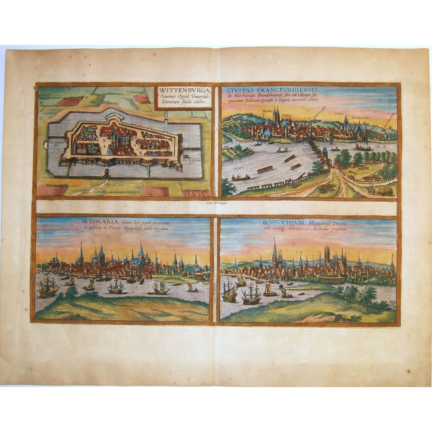
Wittenburga Saxoniae oppidum. . .[on sheet with] Civitas Francfordiensis In Marchionatu Brandeburgensi. . .Wismaria. . .Rostochium. . .
| Maker: | BRAUN, G. / HOGENBERG, F. | |
| Date: | Cologne, 1572 | |
| Colored: | Colored. | |
| Size: | 296 x 455 mm / 11.7 x 17.9 inches | |
| Condition: | In generally good condition, with uniform natural age toning of the paper by age, occasional foxing mostly in the margins. | |
Selling price: $ Please login to see price!
Sold in 2021
Missed this item !
Add your name to our mailing list and be the first to get notified about our newly added listings.
.





Description
A fine antique copper engraved sheet with one map/plan and three panoramic views by Braun and Hogenberg: Wittenberg, Frankfurt an der Oder, Wismar and Rostock . From 'Civitates Orbis Terrarum', liber primus, 1572.
WITTENBERG. CARTOUCHE: Wittenberg, the Saxon town, universally famous for its cultivation of the sciences.
COMMENTARY BY BRAUN: "Wittenberg, in our day the seat of the Dukes of Saxony, is supposed to take its name, so some people think, from Widukind of Saxony, the first Christian prince of Saxony. In 1502 Elector Frederick III, the son of Ernst, Elector of Saxony, founded a university in this town following the example of Leipzig and Tübingen."
The view of Wittenberg across the Elbe is unspectacular: the single church rising above the town centre, its two massive towers topped by octagonal turrets, is the town church of St Mary, which became the mother church of the Reformation.
Wittenberg's palace and palace church are rendered in a relatively inconspicuous manner on the far left of the picture. In 1293 Duke Albert II made Wittenberg his residence. 1502 saw the foundation of the Leucorea University, where from 1508 onwards Martin Luther taught as professor of biblical exegesis.
FRANKFURT AN DER ODER. CAPTION: The city of Frankfurt an der Oder in the Margraviate of Brandenburg, famous for a university with the best opportunities for learning and as a centre of commerce.
COMMENTARY BY BRAUN: "Frankfurt is a magnificent city situated in the Brandenburg March; to the east it lies on the Oder, abounding in fish, and to the west, south and north it has countless vineyards. The wine these produce is sold via the Oder to Pomerania, Denmark, Prussia and other surrounding lands.
A university was founded here in 1506, following the example of Leipzig, which was granted privileges by His Most Serene Highness, Elector Joachim, and Pope Alexander VI and Julius II, and also by Emperor Maximilian I."
The engraving shows a view of Frankfurt an der Oder as seen from the east. A number of boats are plying the river in the foreground. Behind them, the city skyline is hallmarked above all by the towers of the parish churches of St Mary (Pfarrkirch) and St Nicholas, today the Friedenskirche.
The city is surrounded by a fortified wall built in the late 13th century, with three gates and some 50 guardhouses and watchtowers. Founded in the 1200s, the settlement rapidly expanded due to its position on crossroads between Paris-Aachen-Berlin-Warsaw-Moscow and the Prague-Meissen-Stettin trade routes.
In 1253 it was granted its charter and in 1430 joined the Hansa. The lively river traffic and the captions signposting the roads to Meissen and Berlin reflect Frankfurt's commercially advantageous location at the intersection of the two trade routes and beside the Oder.
ROSTOCK. [The names of Rostock and Wismar have been transposed and the present plate erroneously identified as Wismar.]
CAPTION: Rostock, a town in the Duchy of Mecklenburg, distinguished for its famous name and academy.
COMMENTARY BY BRAUN: "The port of Rostock lies on the border of Saxony and belongs to the Duke of Mecklenburg; it was once only a castle surrounded by a few farmhouses, but in 1170 the settlement was fortified, surrounded by an embankment, and grew into a town.
It suffered harsh setbacks on several occasions due to internal unrest, fire and other difficulties. It possesses a university, which was founded in 1419 by their Most Serene Highnesses John IV and Albert IV, Princes of Mecklenburg, by the town council, which pays the professors, and with the support of the local inhabitants."
WISMAR. [The names of Rostock and Wismar have been transposed and the present plate erroneously identified as Rostock.]
CAPTION: Wismar, a town in the Duchy of Mecklenburg known for its location, its large population and its buildings.
COMMENTARY BY BRAUN: "A piteous event took place in this city: a carpenter, who sometimes lost his wits and fell into a rage, e.g. while working, took an axe, ran home and with a terrible bellow cleaved his own children in half and also cut down their pregnant mother - so that he murdered two at one stroke. Dear God, is it possible to imagine anything more dreadful than this murder?"
Interestingly, this is the first time that Braun recounts a tale of horror of the kind frequently found in the earlier city chronicles of Hartmann Schedel and Sebastian Munster. These stories were published in the Newen Zeytungen broadsheets that were the forerunners of today's newspapers (Taschen).
The 'Civitates Orbis Terrarum', or the "Braun & Hogenberg", is a six-volume town atlas and the greatest book of town views and plans ever published: 363 engravings, sometimes beautifully colored. It was one of the best-selling works in the last quarter of the 16th century. Georg Braun wrote the text accompanying the plans and views on the verso.
A large number of the plates were engraved after the original drawings of Joris Hoefnagel (1542-1600), who was a professional artist. The first volume was published in Latin in 1572, the sixth volume in 1617. Frans Hogenberg created the tables for volumes I through IV, and Simon van den Neuwel created those for volumes V and VI.
Other contributors were cartographer Daniel Freese, and Heinrich Rantzau. Works by Jacob van Deventer, Sebastian Münster, and Johannes Stumpf were also used. Translations appeared in German and French.
Reference: Van der Krogt 4 - #4859, State 2 (with privilege); Taschen, Br. Hog. - p. 87; Fauser - #15599, #4125, #15573, #12024
Civitates Orbis Terrarum
The Civitates Orbis Terrarum (Atlas of Cities of the World) was the second-oldest printed atlas in world cartography and the first atlas of towns. Its principal creators and authors were the theologian and editor Georg Braun, the most important engraver and publisher Frans Hogenberg, the engraver Simon van den Neuvel, the artist and draftsman Georg (Joris) Hoefnagel, the topographer Jacob van Deventer and others. Although published outside the Netherlands, the Civitates is nevertheless one of the best examples of the Antwerp school of cartography.Key figures in the school included Abraham Ortelius, Gerardus Mercator, and several other geographers. The Civitates reflects the Flemish engraving style typical of Dutch atlases of the period. In addition, correspondence among Braun, Hogenberg, and Ortelius clearly indicates that they conceived the atlas in Antwerp.
The atlas contains more than 500 maps and represents an entire era in the history of town mapping. The atlas was published in six volumes between 1572 and 1617. To obtain the originals for his work, Braun corresponded extensively with map sellers and scholars in different cities and countries. The authors also conducted their own investigations.
However, these were not true geodetic surveys, but detailed on-location drawings of panoramic views of the towns made from some high point. Georg Hoefnagel made most of the engravings that decorate the Civitates, from its first volume to its last, from such drawings. Hoefnagel drew images of many towns in France, Italy, England, and Spain.
He and his son Jacob subsequently created representations of Austrian and Hungarian towns for the Civitates. In addition to these overview plans, the atlas includes more detailed maps based on topographic surveys, particularly those of Jacob van Deventer (15??-1575). Accordingly, the maps show the systematic structure of the towns' layout, with perspective representations of various quarters and individual buildings.
The town usually appears in the background, while the foreground shows the surrounding countryside and detailed depictions of typical town inhabitants.
These visual representations of people not only augmented the maps' content but also served another purpose. Braun and Hogenberg illustrated the Civitates pages with figures of local inhabitants to prevent Turks from using the maps for military purposes, since Islam forbids images of humans.
Of the total number of towns, only a couple of dozen lie outside Europe, in Asia, Africa, and South America. This shows extremely limited cartographic knowledge of the world, due to the insufficient development of science and mapmaking practices in the second half of the sixth century. At the same time, one cannot help but be astonished by the huge quantity of material included in the atlas by the standards of the time.
Braun and Hogenberg's Civitates was an enormous success. It was republished many times and supplemented with new sections. Its maps became exemplary; other publishers frequently reproduced them in smaller formats as illustrations for books and maps.
After Franz Hogenberg's death, Abraham Hogenberg kept the atlas's typographic plates in Cologne. When Abraham died in 1653, his heirs evidently sold them to Johannes Janssonius, an active and skilled publisher of books and atlases in Amsterdam. In 1657, Janssonius issued the atlas in eight volumes in a completely revised edition, with illustrations arranged by country. A large number of quite new engravings were added to it, while outdated prints were omitted. After Janssonius's death in 1664, his grandson Johannes Janssonius van Waesberge acquired the engravings and used some to compile his own atlas, which appeared in 1682. In 1694, the energetic Amsterdam publisher Frederick de Wit purchased van Waesberge's copper plates and equipment at auction; he was well known for his numerous maps and atlases. De Wit organized a new edition, enriched with new engravings.
After de Wit's time, at the turn of the eighteenth century, the copper plates for the atlas passed to the publisher Pieter van der Aa (1659 - 1733). He acquired them in Leyden and used them for an atlas published in 1729. This publication included a diverse mixture of engravings from the sixteenth to eighteenth centuries.
After van der Aa, the publishing house of Covens and Mortier acquired town maps bearing the publisher's imprint of de Wit. Over the centuries, various publishers reproduced these 16th-century perspective views and maps because of their rich historical and geographical content. At the same time, no atlas of the world's cities in the history of global cartography matches the Civitates Orbis Terrarum in size and fullness.
Beyond its historical, geographical, and cartographic significance, the Civitates is also highly artistic. That is why, to this day, the atlas's town maps have adorned the most exquisite interiors and attracted not only specialists in the field but also admirers of fine art.
FAQ - Guarantee - Shipping
This item is available for immediate purchase when a "Add to Cart" or "Inquire Now" button is shown.
Items are sold in the EU margin scheme
Payments are accepted in Euros or US Dollars.
Authenticity Guarantee
 We provide professional descriptions, condition report (based on 45 years experience in the map business)
Paulus Swaen warrants the authenticity of our items and a certificate of authenticity is provided for each acquired lot.
Condition and Coloring
We indicate the condition of each item and use our unique HiBCoR grading system in which four key items determine a map's value: Historical Importance, Beauty, Condition/Coloring and Rarity.
Color Key
We offer many maps in their original black and white condition. We do not systematically color-up maps to make them more sellable to the general public or buyer.
Copper engraved or wood block maps are always hand colored. Maps were initially colored for aesthetic reasons and to improve readability. Nowadays, it is becoming a challenge to find maps in their original colors and are therefor more valuable.
We use the following color keys in our catalog:
Original colors; mean that the colors have been applied around the time the map was issued.
Original o/l colors; means the map has only the borders colored at the time of publication.
Colored; If the colors are applied recently or at the end of the 20th century.
Read more about coloring of maps [+]
Shipping fee
A flat shipping fee of $ 30 is added to each shipment by DHL within Europe and North America. This covers : International Priority shipping, Packing and Insurance (up to the invoice amount).
Shipments to Asia are $ 40 and rest of the world $50
We charge only one shipping fee when you have been successful on multiple items or when you want to combine gallery and auction purchases.
Read more about invoicing and shipping
FAQ
Please have a look for more information about buying in the BuyNow gallery
Many answers are likely to find in the general help section.
MyCollection+

With My Collection+ you can collect all your favorite items in one place. It is free, and anyone can create his or her virtual collection.
Unless you are logged in, the item is only saved for this session. You have to be registered and logged-in if you want to save this item permanently to My Collection+. Read More[+]
Register here, it is free and you do not need a credit card.
Add this item to My Collection+ or click the following link to see My Collection+.
|
Digital Image Download Paulus Swaen maintains an archive of most of our high-resolution rare maps, prints, posters and medieval manuscript scans. We make them freely available for download and study. Read more about free image download |
Click the image for a free small image download. |

YOUR RIGHT TO CANCEL THE PURCHASE OF A LOT
In accordance with the EU Consumer Rights Directive and habitually reside in the European Union you have the right to cancel the contract for the purchase of a lot, without giving any reason.
The cancellation period will expire 14 calendar days from the day after the date on which you or a third party (other than the carrier and indicated by you) acquires, physical possession of the lot. To exercise the right to cancel you must inform Paulus Swaen Inc, of your decision to cancel this contract by a clear statement (e.g. a letter sent by post, or e-mail.
To meet the cancellation deadline, it is sufficient for you to send your communication concerning your exercise of the right to cancel before the cancellation period has expired.
