Subscribe to be notified if similar examples become available.
1575 BRAUN, G. / HOGENBERG, F. - Wissenburgum. Weissenburg [on sheet with] Rubeacum, Vulgo Russach. . .Colmaria, vulgo Kolmar. . .Badense Oppidum Vulgo Ober Badenn.
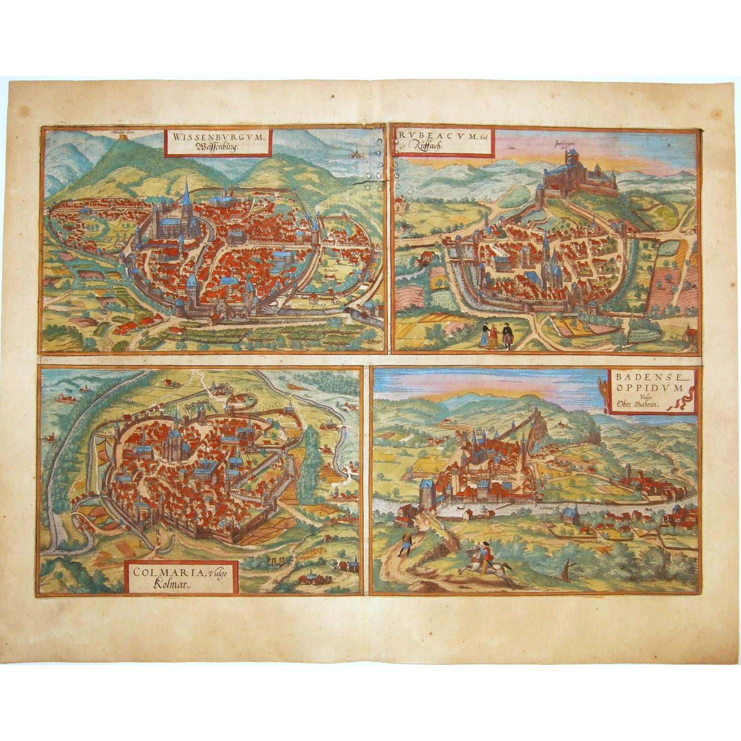
Wissenburgum. Weissenburg [on sheet with] Rubeacum, Vulgo Russach. . .Colmaria, vulgo Kolmar. . .Badense Oppidum Vulgo Ober Badenn.
| Maker: | BRAUN, G. / HOGENBERG, F. | |
| Date: | Cologne, 1575 | |
| Colored: | Colored. | |
| Size: | 335 x 477 mm / 13.2 x 18.8 inches | |
| Condition: | In generally good condition, with uniform natural age toning of the paper by age, occasional foxing in mostly in the margins. | |
Selling price: $ Please login to see price!
Sold in 2021
Missed this item !
Add your name to our mailing list and be the first to get notified about our newly added listings.
.
You can choose from more than 30,000 items from our BuyNow Catalog or Archive.
It's free, and you can delete items anytime.
 Add/Remove this item to MyCollection+




Description
A fine antique copper engraved sheet with four bird's-eye views / plans by Braun and Hogenberg: Wissembourg, Rouffach, Colmar, Baden in Aargau. From: 'Civitates Orbis Terrarum,' ... Part 2.
WISSEMBOURG. COMMENTARY BY BRAUN: "Wissembourg is an old imperial city, and possesses an excellent, good wine, which is almost the only source of income for the burghers of Wissembourg and other nearby small towns; because of its high quality the wine is fetched from a great distance by foreign carters and exported as far as Swabia, Bavaria, Brabant and the Netherlands."
This near bird's-eye view of the city of Wissembourg gives a detailed impression of the layout of this Free Imperial City (1306-1697), which has preserved its medieval character up to today; it is dominated by the abbey church of Saint-Pierre-et Saint-Paul, a Gothic building with a Romanesque bell tower.
Behind it to the right in the plate is the 15th-century Gothic parish church of Saint-Jean. The next biggest building to the right of the town hall was built in 1506 and served up to the 18th century as a stagecoach post where the horses were changed.
The Mundat Stein (top left) marks the boundary of the area received by the Wissembourg monastery in the 8th century as a gift from Pippin the Short. (Mundat is a legal term, derived from the Latin immunitas, marking an area with its own jurisdiction).
ROUFFACH.
CARTOUCHE: Rubeacum, in the vernacular Rouffach.
COMMENTARY BY BRAUN: "Rouffach really is a very old town that was first erected by the Romans. The town had fine buildings and suburbs and was favoured by the nobility because of the great fertility of the farmland, which meant that all the necessities of life could be had here.
But nothing on this earth is constant and everything goes up and down according to good luck and misfortune, so that the town of Rouffach, too, has suffered misfortune several times during its 1,000 years of felicity."
This view in cavalier perspective shows the small Alsatian town of Rouffach, which in the Middle Ages was the residence of the Merovingian kings and was then given to the archbishopric of Strasbourg as a gift.
We can clearly see the church of Notre-Dame de l'Assomption, built in yellow sandstone, on the left the church and monastery of the Franciscans (Fratres Minores) and, below the castle of Isenbourg, the so-called Witch Tower, a jail dating from the 13th to the 15th century.
As the chief town of the archiepiscopal fief, Rouffach quickly became a wealthy city. Its prosperity ended with the Thirty Years' War, for the Swedes destroyed Rouffach irreparably.
COLMAR. CARTOUCHE: Colmaria, in German Colmar. COMMENTARY BY BRAUN: "Colmar lies on fertile soil, for vines and corn grow there. The city is in the middle of Alsace, one mile away from Kaiserberg, Ammersweiler, Reichenweier and Rappoltsweiler, where the best vineyards in the Alsace are found."
This view in cavalier perspective shows the vineyards surrounding Colmar and the layout of the city. Large parts of its medieval silhouette are still preserved today. The church labelled Summum Templum is the Gothic parish church of St Martin, which, with its 71-m-high tower, rises above all other buildings in Colmar.
To the left of the parish church is the 13th-century Dominican church. By 1575 the Reformation made its way to Colmar. Colmar grew out of a Carolingian royal court. It was granted market and city rights in the early 13th century, and from 1282 onwards it was extended to become one of the mightiest fortresses in the Empire; the fortifications, which can be seen here, have partially been preserved and today form promenades in the inner city.
BADEN IN AARGAU. CARTOUCHE: The town of Oppidum Badense, in German Baden. COMMENTARY BY BRAUN: "This town was known and inhabited at the time of Tacitus and even long before; he described it in these words: It is said to be a charming town with beneficial hot-spring water and a fortified castle on the Limmat. Today Baden is a small town with two castles or fortresses, although the upper castle is ruined. [...] There are over 30 different baths, in which even the common man and the peasants can bathe."
View of the little town of Baden in Aargau from the far side of the Limmat. On the far right is the spa with the sulphur springs that have been known since Roman times as Vicus Aqua Helveticae, or Badenia. Visible are the 15th-century tower (with the city wall to its right) and the medieval castle on the hill (Arx), built in the 11the century by the Counts of Lenzburg.
At the end of the bridge is the bailiff's castle, which at the time of Braun and Hogenberg was the official residence of the Confederate governor of Baden. At the foot of the castle hill lies the late Gothic parish church of St Mary's Assumption. In a public disputation on the Reformation in 1526 the citizens of Baden decided in favour of Catholicism. (Taschen)
The four views are engraved after woodcuts published in Münster's 'Cosmographia', 1550.
The 'Civitates Orbis Terrarum', or the "Braun & Hogenberg", is a six-volume town atlas and the greatest book of town views and plans ever published: 363 engravings, sometimes beautifully colored. It was one of the best-selling works in the last quarter of the 16th century. Georg Braun wrote the text accompanying the plans and views on the verso.
A large number of the plates were engraved after the original drawings of Joris Hoefnagel (1542-1600), who was a professional artist. The first volume was published in Latin in 1572, the sixth volume in 1617. Frans Hogenberg created the tables for volumes I through IV, and Simon van den Neuwel created those for volumes V and VI.
Other contributors were cartographer Daniel Freese, and Heinrich Rantzau. Works by Jacob van Deventer, Sebastian Münster, and Johannes Stumpf were also used. Translations appeared in German and French.
Reference: Van der Krogt 4, 4855; Taschen, Braun and Hogenberg, p.173.
Civitates Orbis Terrarum
The Civitates Orbis Terrarum (Atlas of Cities of the World) was the second-oldest printed atlas in world cartography and the first atlas of towns. Its principal creators and authors were the theologian and editor Georg Braun, the most important engraver and publisher Frans Hogenberg, the engraver Simon van den Neuvel, the artist and draftsman Georg (Joris) Hoefnagel, the topographer Jacob van Deventer and others. Although published outside the Netherlands, the Civitates is nevertheless one of the best examples of the Antwerp school of cartography.Key figures in the school included Abraham Ortelius, Gerardus Mercator, and several other geographers. The Civitates reflects the Flemish engraving style typical of Dutch atlases of the period. In addition, correspondence among Braun, Hogenberg, and Ortelius clearly indicates that they conceived the atlas in Antwerp.
The atlas contains more than 500 maps and represents an entire era in the history of town mapping. The atlas was published in six volumes between 1572 and 1617. To obtain the originals for his work, Braun corresponded extensively with map sellers and scholars in different cities and countries. The authors also conducted their own investigations.
However, these were not true geodetic surveys, but detailed on-location drawings of panoramic views of the towns made from some high point. Georg Hoefnagel made most of the engravings that decorate the Civitates, from its first volume to its last, from such drawings. Hoefnagel drew images of many towns in France, Italy, England, and Spain.
He and his son Jacob subsequently created representations of Austrian and Hungarian towns for the Civitates. In addition to these overview plans, the atlas includes more detailed maps based on topographic surveys, particularly those of Jacob van Deventer (15??-1575). Accordingly, the maps show the systematic structure of the towns' layout, with perspective representations of various quarters and individual buildings.
The town usually appears in the background, while the foreground shows the surrounding countryside and detailed depictions of typical town inhabitants.
These visual representations of people not only augmented the maps' content but also served another purpose. Braun and Hogenberg illustrated the Civitates pages with figures of local inhabitants to prevent Turks from using the maps for military purposes, since Islam forbids images of humans.
Of the total number of towns, only a couple of dozen lie outside Europe, in Asia, Africa, and South America. This shows extremely limited cartographic knowledge of the world, due to the insufficient development of science and mapmaking practices in the second half of the sixth century. At the same time, one cannot help but be astonished by the huge quantity of material included in the atlas by the standards of the time.
Braun and Hogenberg's Civitates was an enormous success. It was republished many times and supplemented with new sections. Its maps became exemplary; other publishers frequently reproduced them in smaller formats as illustrations for books and maps.
After Franz Hogenberg's death, Abraham Hogenberg kept the atlas's typographic plates in Cologne. When Abraham died in 1653, his heirs evidently sold them to Johannes Janssonius, an active and skilled publisher of books and atlases in Amsterdam. In 1657, Janssonius issued the atlas in eight volumes in a completely revised edition, with illustrations arranged by country. A large number of quite new engravings were added to it, while outdated prints were omitted. After Janssonius's death in 1664, his grandson Johannes Janssonius van Waesberge acquired the engravings and used some to compile his own atlas, which appeared in 1682. In 1694, the energetic Amsterdam publisher Frederick de Wit purchased van Waesberge's copper plates and equipment at auction; he was well known for his numerous maps and atlases. De Wit organized a new edition, enriched with new engravings.
After de Wit's time, at the turn of the eighteenth century, the copper plates for the atlas passed to the publisher Pieter van der Aa (1659 - 1733). He acquired them in Leyden and used them for an atlas published in 1729. This publication included a diverse mixture of engravings from the sixteenth to eighteenth centuries.
After van der Aa, the publishing house of Covens and Mortier acquired town maps bearing the publisher's imprint of de Wit. Over the centuries, various publishers reproduced these 16th-century perspective views and maps because of their rich historical and geographical content. At the same time, no atlas of the world's cities in the history of global cartography matches the Civitates Orbis Terrarum in size and fullness.
Beyond its historical, geographical, and cartographic significance, the Civitates is also highly artistic. That is why, to this day, the atlas's town maps have adorned the most exquisite interiors and attracted not only specialists in the field but also admirers of fine art.
FAQ - Guarantee - Shipping
This item is available for immediate purchase when a "Add to Cart" or "Inquire Now" button is shown.
Items are sold in the EU margin scheme
Payments are accepted in Euros or US Dollars.
Authenticity Guarantee
 We provide professional descriptions, condition report (based on 45 years experience in the map business)
Paulus Swaen warrants the authenticity of our items and a certificate of authenticity is provided for each acquired lot.
Condition and Coloring
We indicate the condition of each item and use our unique HiBCoR grading system in which four key items determine a map's value: Historical Importance, Beauty, Condition/Coloring and Rarity.
Color Key
We offer many maps in their original black and white condition. We do not systematically color-up maps to make them more sellable to the general public or buyer.
Copper engraved or wood block maps are always hand colored. Maps were initially colored for aesthetic reasons and to improve readability. Nowadays, it is becoming a challenge to find maps in their original colors and are therefor more valuable.
We use the following color keys in our catalog:
Original colors; mean that the colors have been applied around the time the map was issued.
Original o/l colors; means the map has only the borders colored at the time of publication.
Colored; If the colors are applied recently or at the end of the 20th century.
Read more about coloring of maps [+]
Shipping fee
A flat shipping fee of $ 30 is added to each shipment by DHL within Europe and North America. This covers : International Priority shipping, Packing and Insurance (up to the invoice amount).
Shipments to Asia are $ 40 and rest of the world $50
We charge only one shipping fee when you have been successful on multiple items or when you want to combine gallery and auction purchases.
Read more about invoicing and shipping
FAQ
Please have a look for more information about buying in the BuyNow gallery
Many answers are likely to find in the general help section.
MyCollection+

With My Collection+ you can collect all your favorite items in one place. It is free, and anyone can create his or her virtual collection.
Unless you are logged in, the item is only saved for this session. You have to be registered and logged-in if you want to save this item permanently to My Collection+. Read More[+]
Register here, it is free and you do not need a credit card.
Add this item to My Collection+ or click the following link to see My Collection+.
|
Digital Image Download Paulus Swaen maintains an archive of most of our high-resolution rare maps, prints, posters and medieval manuscript scans. We make them freely available for download and study. Read more about free image download |
Click the image for a free small image download. |

YOUR RIGHT TO CANCEL THE PURCHASE OF A LOT
In accordance with the EU Consumer Rights Directive and habitually reside in the European Union you have the right to cancel the contract for the purchase of a lot, without giving any reason.
The cancellation period will expire 14 calendar days from the day after the date on which you or a third party (other than the carrier and indicated by you) acquires, physical possession of the lot. To exercise the right to cancel you must inform Paulus Swaen Inc, of your decision to cancel this contract by a clear statement (e.g. a letter sent by post, or e-mail.
To meet the cancellation deadline, it is sufficient for you to send your communication concerning your exercise of the right to cancel before the cancellation period has expired.
