Subscribe to be notified if similar examples become available.
1482 PTOLEMY, C. - [Untitled world map] 'Insculptum est per Iohanne Schnitzer de Artmsheim' ]
[Untitled world map] 'Insculptum est per Iohanne Schnitzer de Artmsheim' ]
| Maker: | PTOLEMY, C. | |
| Date: | Ulm, 1482 | |
| Colored: | Colored. | |
| Size: | 360 x 508 mm / 14.2 x 20 inches | |
| Condition: | colored wood block print on paper. The upper, right- and upper half of left hand margin cropped till the outer border line. Lower margin is 10 till 12mm, with some reinforcement of marginal tears. Two small wormholes in lower part center fold filled up. | |
 Add/Remove this item to MyCollection+




Description
The map is the first to be signed with the signature of the engraver ?Johanne Schnitzer de Armssheim.?
The world map shows for the first time some changes in Ptolemy?s traditional conceptions.
-- The World Encompassed. Geographically, the Ulm Ptolemy ?ventures to represent some features which update the Ptolemaic world picture and which were very probably based on a manuscript of Donnus Nicolaus Germanus of the 1470s?
-- Shirley. It shows the beginnings of an expansion of the circumscribed, pre-Columbian view of the world. Unlike previous maps, which show the northern limit of the known world to be Scotland, here we have a rudimentary appearance of Scandinavia.
The Ulm Ptolemy was printed by Leinhart Holle, whose business went bankrupt shortly after publication. His stock was taken over by Johann Reger, who published another edition in 1486 using the same blocks.
This wood block print is printed on heavy paper. The map has as often, trimmed margins. A few small marginal splits are professionally verso reinforced. Centerfold is verso reinforced due to the usual paperthinning, a small horizontal tear of 12mm (next to the Arabian peninsular) has been reinforced also. The colors are applied recently but are definitely period correct. The map makes great presentation and is generally in very good condition.
Following is a high resolution scan of the verso of the map. The earlier mentioned restorations are very hardly notable on the scan, simply because they are minor, well done, and only visible when holding the map against light!
Reference: Shirley, The Mapping of The World, 10, plate 20, Rarity Index R; The World Encompassed, #37, plate XI.
Claudius Ptolemy (c. 85-165)
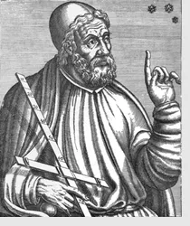 Claudius Ptolemaeus, better known as Ptolemy, was the most accomplished and influential astronomer of the ancient world, and his work dominated the field until the mid-17th century. He lived in Alexandria, Egypt. Almost nothing is known about Ptolemy's life, as historical sources from the time period are scarce. Today, Ptolemy is known almost exclusively through his work and they have influenced other thinkers over the centuries.
Ptolemy wrote his Geographia around the year 150 AD which compiled existing knowledge about the world’s geography at the time. The work refered to a system of latitude and longitude, as well as a means of describing locations on earth based on astronomical observations from those areas. Ptolemy’s original maps from the work were never found, having presumably been lost over the years, but his work was descriptive enough that cartographers were able to recreate his observations in 1300 AD, and create the Ptolemy map.
His world map is notable for its probable role in the Roman expansion. Ptolemy’s idea of using a latitude and longitude system had a significant impact on the work of later cartographers.
Astronomy
There were many accomplished Greek astronomers before Ptolemy (and many Babylonian astronomers before them), but Ptolemy stands out because he wrote a complete treatise on the principles and techniques of astronomy, and that treatise survived to be translated into Arabic and Latin and shape the course of medieval and Renaissance astronomy. Ptolemy's book is often referred to as the Almagest, from an Arabic title meaning "the greatest," i.e., the largest of his astronomical treatises.
The Almagest was translated into Arabic during the Golden Age of Islam, and later, in the medieval West, into Latin, first from Arabic, and eventually from the original Greek, when Greek manuscripts became available in the Renaissance.
FAQ - Guarantee - Shipping
Buying in the BuyNow Gallery
This item is available for immediate purchase when an "Add to Cart" or "Inquire Now" button is shown.
Items are sold in the EU margin scheme.
Payments are accepted in Euros or US Dollars.
Authenticity Guarantee
 We provide professional descriptions and a condition report (based on 45 years experience in the map business).
Paulus Swaen warrants the authenticity of our items and a certificate of authenticity is provided for each acquired lot.
Condition and Coloring
We indicate the condition of each item and use our unique HiBCoR grading system in which four key items determine a map's value:
Historical Importance, Beauty, Condition/Coloring and Rarity.
We offer many maps in their original black and white condition. We do not systematically color-up maps to make them more sellable to the general public or buyer.
Copper engraved or wood block maps are always hand colored. Maps were initially colored for aesthetic reasons and to improve readability.
Nowadays it is becoming a challenge to find maps in their original colors, and these are therefore more valuable.
We use the following color keys in our catalog:
- Original colors: the colors were applied around the time the map was issued.
- Original o/l colors: only the borders were colored at the time of publication.
- Colored: the colors were applied recently or at the end of the 20th century ("attractive colors" may also be used).
Read more about coloring of maps [+]
Shipping fee
A flat shipping fee of $30 is added to each shipment by DHL within Europe and North America. This covers international priority shipping, packing and insurance (up to the invoice amount).
Shipments to Asia are $40 and rest of the world $50.
We charge only one shipping fee when you have been successful on multiple items or when you want to combine gallery and auction purchases.
Read more about invoicing and shipping
FAQ
Please have a look for more information about buying in the BuyNow gallery.
Many answers are likely to be found in the general help section.
MyCollection+

With MyCollection+ you can collect all your favorite items in one place. It is free, and anyone can create his or her virtual collection.
Unless you are logged in, the item is only saved for this session. You have to be registered and logged in if you want to save this item permanently.
Read more [+]
Register here, it is free and you do not need a credit card.
Add this item to
MyCollection+
or see MyCollection+.
Paulus Swaen maintains an archive of most of our high-resolution rare maps, prints, posters and medieval manuscript scans.
We make them freely available for download and study.
Read more about free image download
Click the image for a free small image download.
![Rare, antique map of [Untitled world map] 'Insculptum est per Iohanne Schnitzer de Artmsheim' ]](/uploads/23731.jpg)
YOUR RIGHT TO CANCEL THE PURCHASE OF A LOT
In accordance with the EU Consumer Rights Directive and habitually reside in the European Union you have the right to cancel the contract for the purchase of a lot, without giving any reason.
The cancellation period will expire 14 calendar days from the day after the date on which you or a third party (other than the carrier and indicated by you) acquires, physical possession of the lot. To exercise the right to cancel you must inform Paulus Swaen Inc, of your decision to cancel this contract by a clear statement (e.g. a letter sent by post, or e-mail.
To meet the cancellation deadline, it is sufficient for you to send your communication concerning your exercise of the right to cancel before the cancellation period has expired.