Subscribe to be notified if similar examples become available.
Unique world atlas by Louis Joseph Mondhare. |
||||||||||||||||||||
|
||||||||||||||||||||
|
|
||||||||||||||||||||
|
Selling price: $ Please login to see price!
Sold in 2018 Missed this item! Add your name to our mailing list and be the first to get notified about our newly added listings. . |
My Collection + - Save and collect this or any of your favorite items in one place.
If you want to save the items permanently, please sign in or create account first. |
|||||||||||||||||||
Description
The atlas seems to be an attempt to publish a folio world atlas, maybe on Pierre Jean’s initiative.
So far, it is the only known example of a folio world atlas published by Mondhare. He used maps, title and table of Sanson/Jaillot ‘s Atlas nouveau but considerably updated the world map and the continents. The date has been changed in 1785 for the first 6 maps and the name of Mondhare added on the World, Europe, Africa, North and South America maps. Now the routes of the explorers since Magellan untill Cook, are shown on the world and continents maps. The Mer de l’Ouest (Sea of the West) has been added on the America map. The world map is now decorated with 4 circular astronomical diagrams.
Louis Joseph Mondhare (1734-99) was a native of Bougy (Normandy), but he worked in Paris from 1759 until his death as an engraver, publisher, map and print seller. He maintained offices in Paris and Cadiz. From June 1784 onwards he worked in association with his son-in-law Pierre Jean, a print seller. He published a school atlas Atlas Général a l'usage des colleges et maisons d'éducation, several smaller atlases and the wall maps of Clouet.
Content
- Title-page from Hubert Jaillot Atlas Nouveau, contenant toutes les parties du Monde, ou sont exactement remarqués les empires, monarchies, royaumes, estats, republiques, dated 1692.
- Engraved contents page "Table des cartes etc : du Sr. Sanson. Contenues dans Ce Vollume". The centre part has remained empty. Beautifully old colored.
- Mappe-Monde Geo-Hydrographique, ou Description Generale du Globe Terrestre et Aquatique en Deux Plans-Hemispheres ; ... Par le sieur Sanson, Geographe ordinaire du roy. 1785. Revue Corrigée et Augmentée des Nouvelles Decouvertes et des Voyages des Plus Celebres Navigateurs dans la Mer du Sud et au Nord de l'Asie. 1785. A Paris chez Mondhare rue St. Jean de Beauvais.
Unknown world map in double-hemisphere projection after Jaillot, including the routes of Magellan, Mendaña, Tasman, Le Maire, Halley, Furneaux, Bougainville, and, of course, Cook. One of the most recent discoveries recorded on the map are the Sandwich Islands, or Hawaii. It was known by 1785 that Cook had perished there, making the islands of considerable interest to Europeans.
The map is featured by the M. de l’Ouest “Sea of the West”
Ornated around the edge with 4 astronomical diagrams representing the solar systems theories of Ptolemy, Tycho Brahe, Copernicus and a composite system.
- L’Europe divisée… chez Mondhare, 1785. Tracks of Cook, Clark and Gore
- L’Asie divisée… , 1785. Tracks of Cook, Clark, Gore and route of the Spanish fleet from Manilla to Acapulco.
- L’Afrique divisée… et présentement chez Mondhare rue St. Jean de Beauvais, 1785. Tracks of Furneaux, Cook and Clark.
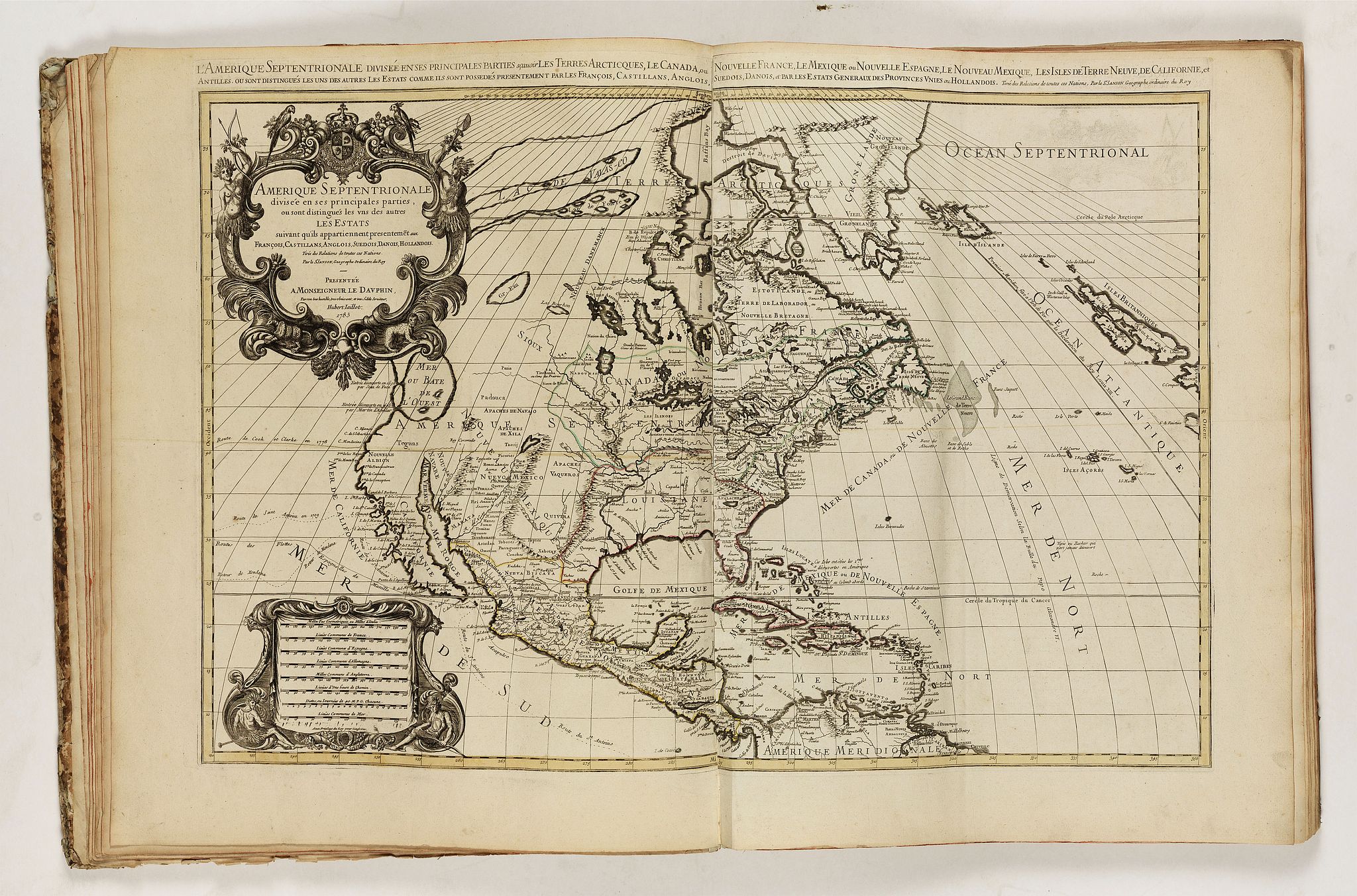
- Amérique Septentrionale divisée…, 1785.
“The most notable difference is the addition of the date 1785 to the title and the presence of a MER OU BAYE DE L’OUEST. Jaillot’s imprint is removed from the scale cartouche lower left leaving the privilege. Further additions to the cartography of the north west can be found. The Route de Cook et Clarke en 1778 is added to the Pacific. Boston is finally added to the map however; the cartography of the south east remains Francophile. Despite this leaning there is still no reference to New Orleans founded in 1718. AMERIQUE SEPTENTRIONALE is written across the middle and FLORIDE is replaced by LOUISIANE. Several more minor alterations are also made.”
Burden, Corrigenda and Addenda : Jaillot, State 6.
- Amérique méridionale…, 1785. With routes of Magellan, Mendana, Fernand Quiros, Le Maire, Comodore Biron, Saint Antoine, Bougainville, Furneaux, Cook, St. Louis, Mr Halley.
- Les Isles Britanniques... H. jaillot, 1692
- Le Royaume d’Angleterre... H. Jaillot, 1693
- Le Royaume d’Ecosse... H. Jaillot, 1693
- Le Royaume d’Irlande... H. Jaillot, 1693
- Carte de la Manche... H. Jaillot, 1692
- La Scandinavie... H. Jaillot, 1696
- Le Royaume de Danemark ou sont les Isles de Seelande... H. Jaillot, 1692
- La Russie Blanche ou Moscovie... H. Jaillot, 1692
- Le Royaume de France... H. Jaillot, 1692
- La Bretagne... le Sr. Sanson, 1696
- Le Gouvernement General de Picardie... H. Jaillot, 1692
- Le Gouvernement General de l’Isle de France ... ... H. Jaillot, 1692
- Gouvernement General de Paris... H. Jaillot, 1692
- Gouvernement General de Champagne... H. Jaillot, 1692
- Le Gouvernement d’Orleans... H. Jaillot, 1693
- Le Gouvernement General du Dauphiné... ... H. Jaillot, 1692
- Gouvernement General de Provence... H. Jaillot, 1692
- Le Duché et Gouvernement de Normandie... I. B. Nolin, 1742
- Le Comté d’Artois... H. Jaillot, 1696
- La Franche-Comté... H. Jaillot, 1692
- La Lorraine... H. Jaillot, 1692
- L’Alsace... H. Jaillot, 1692
- Carte particuliere des Postes de France... H. Jaillot, 1693
- L’Espagne... H. Jaillot, 1692
- Principauté de Catalogne… H. Jaillot, 1696
- L’Italie Divisée... H. Jaillot, 1692
- Les Estats de Savoye et de Piemont... I.B. Nolin, 1691
- Partie du Duché de Milan... H. Jaillot, 1692
- Les Monts Pyrenées ... H. Jaillot, 1691
- Les Montagnes des Alpes... H. Jaillot, 1692
- Le Royaume de Naples... I. B. Nolin
- La Sicile... H. Jaillot, 1692
- Le Golfe de Venise... H. Jaillot, 1693
- La Mer Méditerranée... H. Jaillot, 1696
Some samples of maps in this atlas :
FAQ - Guarantee - Shipping
Buying in the BuyNow Gallery
This item is available for immediate purchase when a "Add to Cart" or "Inquire Now" button is shown.
Items are sold in the EU margin scheme
Payments are accepted in Euros or US Dollars.
Authenticity Guarantee
 We provide professional descriptions, condition report (based on 45 years experience in the map business)
Paulus Swaen warrants the authenticity of our items and a certificate of authenticity is provided for each acquired lot.
Condition and Coloring
We indicate the condition of each item and use our unnique HiBCoR grading system in which four key items determine a map's value: Historical Importance, Beauty, Condition/Coloring and Rarity.
Color Key
We offer many maps in their original black and white condition. We do not systematically color-up maps to make them more sellable to the general public or buyer.
Copper engraved or wood block maps are always hand colored. Maps were initially colored for aesthetic reasons and to improve readability. Nowadays, it is becoming a challenge to find maps in their original colors and are therefor more valuable.
We use the following color keys in our catalog:
Original colors; mean that the colors have been applied around the time the map was issued.
Original o/l colors; means the map has only the borders colored at the time of publication.
Colored; If the colors are applied recently or at the end of the 20th century.
Read more about coloring of maps [+]
Shipping fee
A flat shipping fee of $ 30 is added to each shipment by DHL within Europe and North America. This covers : International Priority shipping, Packing and Insurance (up to the invoice amount).
Shipments to Asia are $ 40 and rest of the world $50
We charge only one shipping fee when you have been successful on multiple items or when you want to combine gallery and auction purchases.
Read more about invoicing and shipping
FAQ
Please have a look for more information about buying in the BuyNow gallery
Many answers are likely to find in the general help section.
My Collection+
![]()
With My Collection+ you can collect all your favorite items in one place. It is free, and anyone can create his or her virtual collection.
Unless you are logged in, the item is only saved for this session. You have to be registed and logged-in if you want to save this item permanently to My Collection+.
Read More[+]
Register here, it is free and you do not need a credit card.
Add this item to
My Collection+
or click the following link to see My Collection+.
| Digital Image Download | |
|
Paulus Swaen maintains an archive of most of our high-resolution rare maps, prints, posters and medieval manuscript scans. We make them freely available for download and study. Read more about free image download |
Click the image for a free small image download. |
In accordance with the EU Consumer Rights Directive and habitually reside in the European Union you have the right to cancel the contract for the purchase of a lot, without giving any reason.
The cancellation period will expire 14 calendar days from the day after the date on which you or a third party (other than the carrier and indicated by you) acquires, physical possession of the lot. To exercise the right to cancel you must inform Paulus Swaen Inc, of your decision to cancel this contract by a clear statement (e.g. a letter sent by post, or e-mail (amsterdam@swaen.com).
To meet the cancellation deadline, it is sufficient for you to send your communication concerning your exercise of the right to cancel before the cancellation period has expired.
