Please login to see price!.
Subscribe to be notified if similar examples become available.
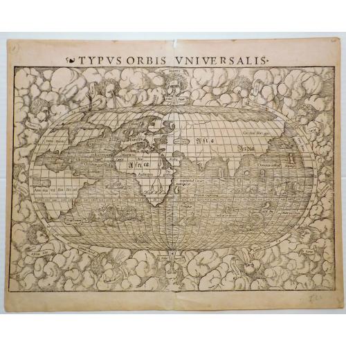
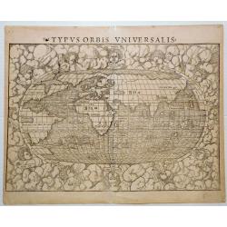
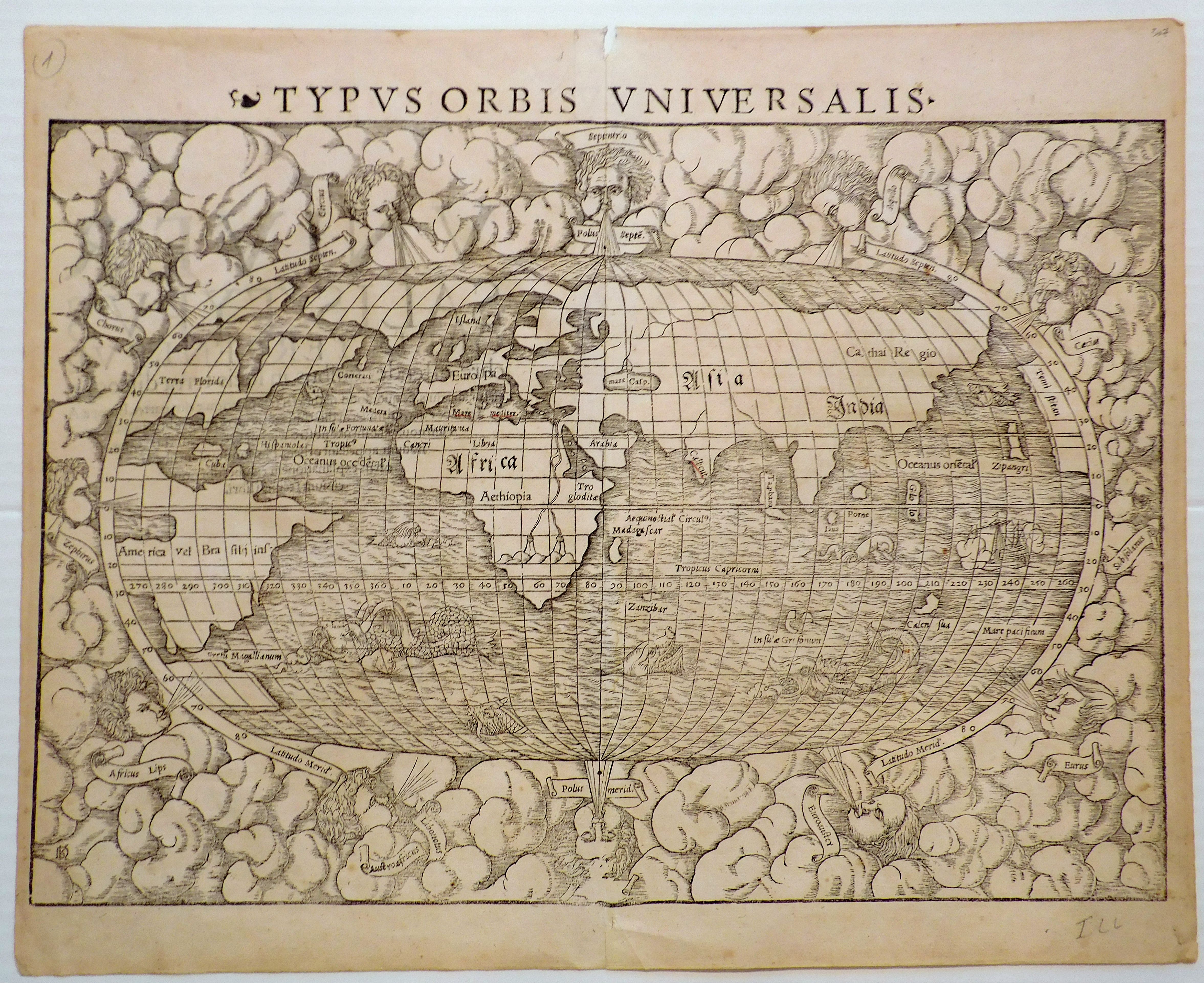
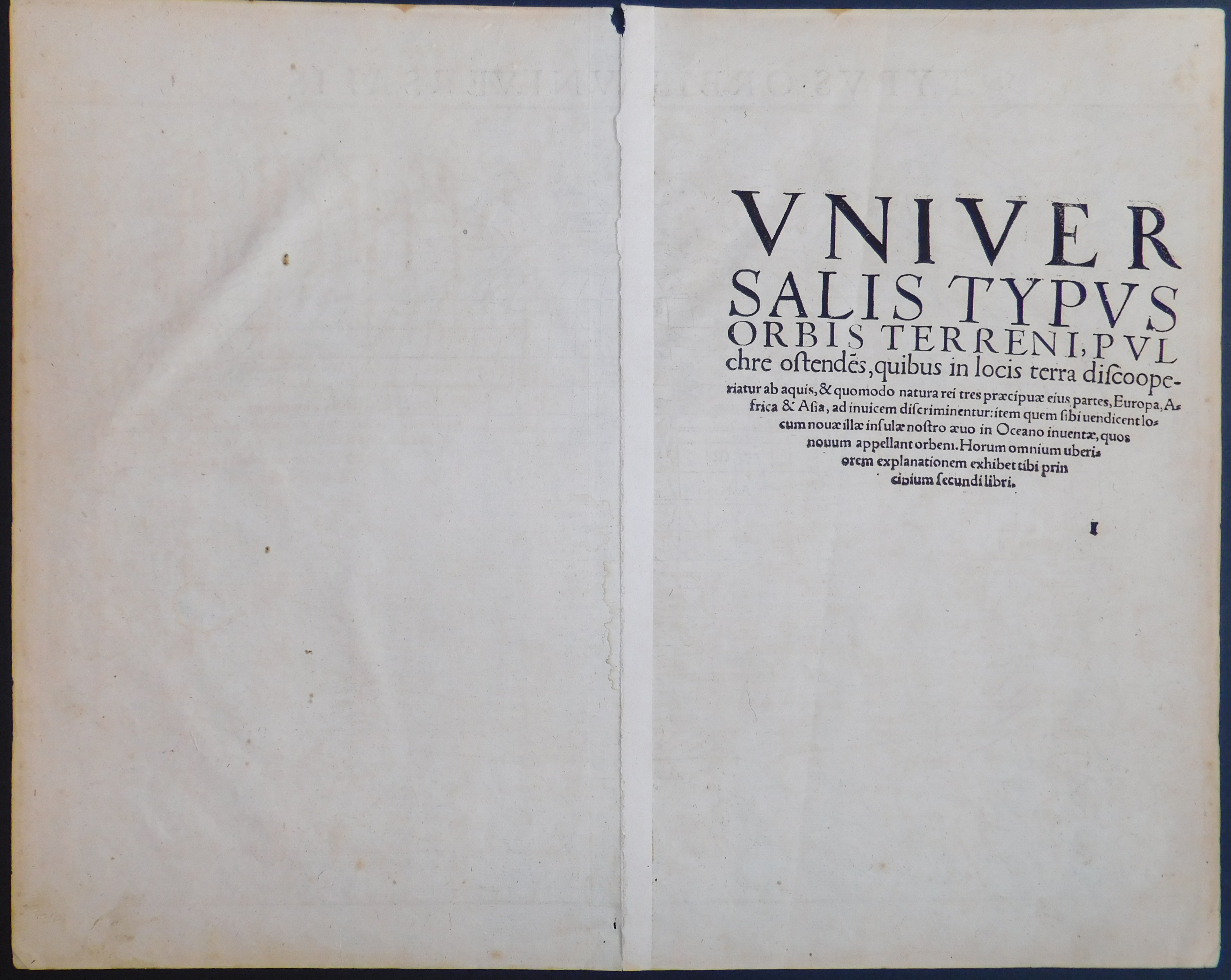
Typus Orbis Universalis |
||||||||||||||||||||
|
||||||||||||||||||||
|
|
||||||||||||||||||||
|
Selling price: $...
Please login to see price! Sold in 2023 Missed this item! Be the first to get notified about our newly added listings. Add your name to our mailing list. Feel free to contact us if you have a question about this item. |
||||||||||||||||||||
Description
The second edition of Münster’s map of the world is one of the most recognized and influential world maps of the sixteenth century. Today, it is one of the earliest obtainable world maps. This example is from the second woodblock, which featured in editions of Cosmographia from 1550 with significant revisions from the first edition.
North America is broken up, with the bulk of the continent on the left and the west coast appearing briefly on the right side of the oval projection. Münster is non-committal as to the continuity of North and South America; an unbroken Central America is implied but is not clearly shown thanks to the curve of the projection.
Sebastian Münster's Typus Orbis Universalis, also known as the "Cosmographia," is a significant work in the history of cartography and geography. Published in 1544, it was one of the first books to provide a comprehensive and detailed depiction of the known world. The book included maps, illustrations, and descriptions of various regions and countries, as well as information on their history, culture, and economy.
This map provides a general but good outline of the known world in the mid-16th century. The map is based on reports and a mix of information from Verrazano’s exploration which confused the Chesapeake for the Indian Ocean and Cartier’s voyages searching for the Northwest passage. North America is named Terra Florida and the Pacific Ocean is labeled as Mare Pacificum.
Münster, a German cartographer and geographer, drew upon a wide range of sources for the Cosmographia, including Ptolemy's Geography, classical texts, and the accounts of explorers and traders. He also drew upon his own extensive travels throughout Europe, which gave him firsthand knowledge of the places he depicted.
The Typus Orbis Universalis was revolutionary for its time, as it represented a significant departure from the traditional medieval maps that focused primarily on religious and biblical themes. Munster's maps were based on scientific principles and were designed to be as accurate as possible. They showed the correct shapes of continents and seas, and included detailed information on the
locations of cities, rivers, and mountains.
The book was widely popular and went through several editions, becoming one of the most widely circulated books of the 16th century. The maps and illustrations in the book served as a source of inspiration for other cartographers and geographers, and many later maps were directly influenced by Munster's work.
Reference: Shirley, Rodney W., The Mapping of the World: Early Printed World Maps 1472-1700.
Münster, a German cartographer and geographer, drew upon a wide range of sources for the Cosmographia, including Ptolemy's Geography, classical texts, and the accounts of explorers and traders. He also drew upon his own extensive travels throughout Europe, which gave him firsthand knowledge of the places he depicted.
The Typus Orbis Universalis was revolutionary for its time, as it represented a significant departure from the traditional medieval maps that focused primarily on religious and biblical themes. Munster's maps were based on scientific principles and were designed to be as accurate as possible. They showed the correct shapes of continents and seas, and included detailed information on the locations of cities, rivers, and mountains.
The book was widely popular and went through several editions, becoming one of the most widely circulated books of the 16th century. The maps and illustrations in the book served as a source of inspiration for other cartographers and geographers, and many later maps were directly influenced by Munster's work.
Reference: Shirley, Rodney W., The Mapping of the World: Early Printed World Maps 1472-1700.
FAQ - Guarantee - Shipping
Buying in the BuyNow Gallery
This item is available for immediate purchase when a "Add to Cart" or "Inquire Now" button is shown.
Payments are accepted in Euros or US Dollars. We accept most major credit cards, PayPal and bank transfer.
Authenticity Guarantee
 We provide professional descriptions, condition report and HiBCoR rating (based on 45 years experience in the map business)
We fully guarantee the authenticity of items we sell. We provide a certificate of authenticity for each purchased item.
Condition / Coloring
We indicate the condition of each item and use our unnique HiBCoR grading system in which four key items determine a map's value: Historical Importance, Beauty, Condition/Coloring and Rarity.
We offer many maps in their original black and white condition. We do not systematically color-up maps to make them more sellable to the general public or buyer.
Copper engraved or wood block maps are always hand colored. Maps were initially colored for aesthetic reasons and to improve readability. Nowadays, it is becoming a challenge to find maps in their original colors and are therefor more valuable.
We use the following color keys in our catalog:
Original colors; mean that the colors have been applied around the time the map was issued.
Colored; If the colors are applied recently or at the end of the 20th century, then "colored", or "attractive colors" will be used.
Original o/l colors; means the map has only the borders colored at the time of publication.
Read more about coloring of maps [+]
FAQ
Please have a look for more information about buying in the BuyNow gallery.
Many answers are likely to find in the general help section.
Collection
![]()
With Collection you can collect all your favorite items in one place. It is free, and anyone can create his or her virtual map collection.
Unless you are logged in, the item is only saved for this session. You have to be registed and logged-in if you want to save this item permanently to your collection.
Read More [+]
If you want to save the items permanently, please sign in
or create account first. ![]()
Registering Here, it is and you do not need a credit card.
Add this item to
Collection
or click the following link to see my Collection.
Invoice
The invoice and certificates of authenticity are available in the client center >Invoices
| Digital Image Download | |
|
Paulus Swaen maintains an archive of most of our high-resolution rare maps, prints, posters and medieval manuscript scans. We make them freely available for download and study. Read more about free image download |
Click the image for a free small image download. |
In accordance with the EU Consumer Rights Directive and habitually reside in the European Union you have the right to cancel the contract for the purchase of a lot, without giving any reason.
The cancellation period will expire 14 calendar days from the day after the date on which you or a third party (other than the carrier and indicated by you) acquires, physical possession of the lot. To exercise the right to cancel you must inform Paulus Swaen Inc, of your decision to cancel this contract by a clear statement (e.g. a letter sent by post, or e-mail (amsterdam@swaen.com).
To meet the cancellation deadline, it is sufficient for you to send your communication concerning your exercise of the right to cancel before the cancellation period has expired.
