Subscribe to be notified if similar examples become available.

TVSCIA / Per Gerardum Mercatorem. |
||||||||||||||||||||
|
||||||||||||||||||||
|
|
||||||||||||||||||||
|
Selling price: $ Please login to see price!
Sold in 2012 Missed this item! Add your name to our mailing list and be the first to get notified about our newly added listings. . |
My Collection + - Save and collect this or any of your favorite items in one place.
If you want to save the items permanently, please sign in or create account first. |
|||||||||||||||||||
Description
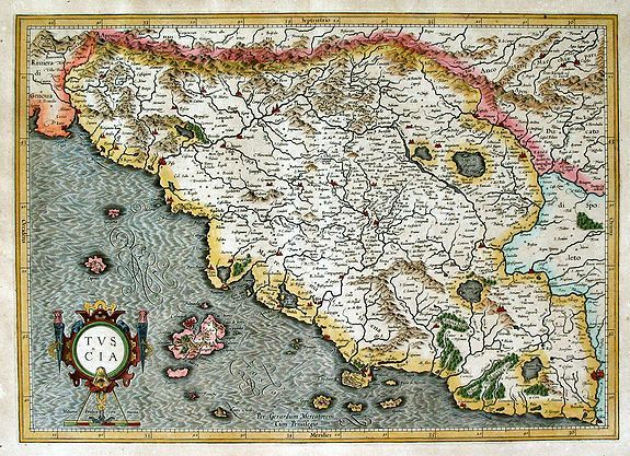
This is a fine, early decorative map by Gerard Mercator of the beautiful area of Tuscany in Italy. The map shows an area extending from just beyond Tuscany. At the lower right on the map is Roma. Part of the Republic of Genoa is at the upper left. All major cities and towns (Florence, Siena, etc.) are on the map as are numerous smaller villages. There is great clarity in the placement and list of numerous cities and towns on the map. Off the coast are various islands including Elba. At the bottom left is the title cartouche with a mileage scale below it.
Gerard Mercator (1512-1594) was one of the most famous geographers of his time. He was renowned as a scholar in his day, and his name is known to this day as the inventor of the map projections named after him. His maps are known for their precise geographic information and for their attention to detail. All of his maps are finely engraving, mostly by Mercator or by one of his family members. He worked initially from Leuven, Flanders, but then from Duisberg in Germany. Around 1563, Mercator became cosmographer to Duke William V of Julich, Kleve.. in Germany.
As the cosmographer, he began the writing of a Cosmography intended to cover, in five volumes, the entire known world. As Mercator was involved in all aspects of the time-consuming Cosmography, from writing the text, drawing the maps, and engraving the copperplates, the atlas was not finished in his lifetime and only sections were finished and published before his death. His son, Rumold, along with other family members finished the various parts and published the final product, including previously published parts, as the Atlas Sive Cosmographicae... in 1595.
In 1589, Gerard Mercator published his section on Italy, including this map, and the surrounding parts of Europe as the Italiae Sclavoniae et Graeciae Tabulae Geographicae. The map also was used for Mercator's Atlas Sive Cosmographicae... in 1595. One further edition of this atlas was published by the Mercator family in Duisberg in 1602 with this same map. In 1604, the copperplates for the atlas were sold to Jodocus Hondius and Cornelis Claesz. In 1606, Hondius introduced a completely revised edition of Mercator's atlas, Atlas sive Cosmographicae...... and used this map from the Mercator plates for inclusion in the atlas, or as it is often called, the Mercator-Hondius atlas.
Jodocus Hondius (1563-1612) was the founder of the famous 17th century Dutch map publishing family. Hondius, along with sons Jodocus II and Henricus and son-in-law Johannes Janssonius, was prominent in Dutch cartography and his family competed aggressively with the emerging Blaeu family map business.
This particular map appeared in the Latin edition of the Mercator Hondius Atlas of 1613 with a signature of "Nnnnnn" and page "292-293" on the verso. Latin text on the verso describes Tuscany. This map last appeared in 1633 in a French edition of the atlas, after which it was replaced with other maps of the region by the Hondius and Janssonius publishing firm (van der Krogt, p. 688-9).
Reference: Van der Krogt, Peter. Koeman's Atlantes Neerlandici, vol. 1. 't Goy-Houten: HES Publishers,1997.
FAQ - Guarantee - Shipping
Buying in the BuyNow Gallery
This item is available for immediate purchase when a "Add to Cart" or "Inquire Now" button is shown.
Items are sold in the EU margin scheme
Payments are accepted in Euros or US Dollars.
Authenticity Guarantee
 We provide professional descriptions, condition report (based on 45 years experience in the map business)
Paulus Swaen warrants the authenticity of our items and a certificate of authenticity is provided for each acquired lot.
Condition and Coloring
We indicate the condition of each item and use our unnique HiBCoR grading system in which four key items determine a map's value: Historical Importance, Beauty, Condition/Coloring and Rarity.
Color Key
We offer many maps in their original black and white condition. We do not systematically color-up maps to make them more sellable to the general public or buyer.
Copper engraved or wood block maps are always hand colored. Maps were initially colored for aesthetic reasons and to improve readability. Nowadays, it is becoming a challenge to find maps in their original colors and are therefor more valuable.
We use the following color keys in our catalog:
Original colors; mean that the colors have been applied around the time the map was issued.
Original o/l colors; means the map has only the borders colored at the time of publication.
Colored; If the colors are applied recently or at the end of the 20th century.
Read more about coloring of maps [+]
Shipping fee
A flat shipping fee of $ 30 is added to each shipment by DHL within Europe and North America. This covers : International Priority shipping, Packing and Insurance (up to the invoice amount).
Shipments to Asia are $ 40 and rest of the world $50
We charge only one shipping fee when you have been successful on multiple items or when you want to combine gallery and auction purchases.
Read more about invoicing and shipping
FAQ
Please have a look for more information about buying in the BuyNow gallery
Many answers are likely to find in the general help section.
My Collection+
![]()
With My Collection+ you can collect all your favorite items in one place. It is free, and anyone can create his or her virtual collection.
Unless you are logged in, the item is only saved for this session. You have to be registed and logged-in if you want to save this item permanently to My Collection+.
Read More[+]
Register here, it is free and you do not need a credit card.
Add this item to
My Collection+
or click the following link to see My Collection+.
| Digital Image Download | |
|
Paulus Swaen maintains an archive of most of our high-resolution rare maps, prints, posters and medieval manuscript scans. We make them freely available for download and study. Read more about free image download |
Click the image for a free small image download. |
In accordance with the EU Consumer Rights Directive and habitually reside in the European Union you have the right to cancel the contract for the purchase of a lot, without giving any reason.
The cancellation period will expire 14 calendar days from the day after the date on which you or a third party (other than the carrier and indicated by you) acquires, physical possession of the lot. To exercise the right to cancel you must inform Paulus Swaen Inc, of your decision to cancel this contract by a clear statement (e.g. a letter sent by post, or e-mail (amsterdam@swaen.com).
To meet the cancellation deadline, it is sufficient for you to send your communication concerning your exercise of the right to cancel before the cancellation period has expired.
