Subscribe to be notified if similar examples become available.
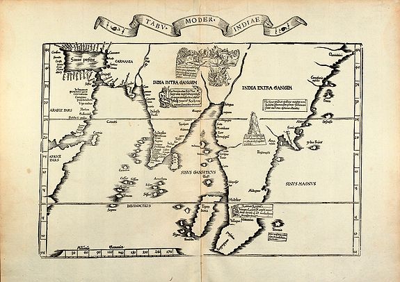
1535 Fries, L. - Tabu. moder. Indiae
Tabu. moder. Indiae |
||||||||||||||||||||
|
||||||||||||||||||||
|
|
||||||||||||||||||||
|
Selling price: $ Please login to see price!
Sold in 2010 Missed this item! Add your name to our mailing list and be the first to get notified about our newly added listings. . |
My Collection +
Add this or any of your favorite items in one place. If you want to save the items permanently, you have to sign in or create an account first.   Add/Remove
 |
|||||||||||||||||||



Description
Woodcut map of India by L. Fries. From the 1535 Lyon edition of Ptolemy's Geographia edited by M. Servetus and published by M. and G. Trechsel, printed from the 1522 woodblocks of the first Fries edition. A sized reduced version of the Waldseemuller maps from 1513, showing the area between eastern Arabia and Indochina.
Reference: Karrow 28/44
Lorenz Fries (1490-
Lorenz (Laurent) Fries was born in Alsace in 1490 or thereabouts, describing himself on one occasion as from Colmar. He studied medicine at university, or rather at universities, as he seems to have had a peripatetic education, apparently spending time at the universities of Pavia, Piacenza, Montpellier and Vienna. Having completed his education, Fries established himself as a physician at a succession of places in the Alsace region and finally settled in Strasbourg in about 1519. By this time, Fries met the Strasbourg printer and publisher Johann Grüninger, an associate of the St. Die group of scholars formed by, among others, Walter Lud, Martin Ringmann, and Martin Waldseemuller. Grüninger.The major project that Fries and Gruninger worked on was a new edition of the Geographia of Claudius Ptolemy, which was published by Johann Koberger in 1522. Here again, Fries evidently edited the maps, in most cases simply producing a reduction of the equivalent map from the 1513 edition of the Geographie Opus Novissima, printed by Johann Schott.
Fries also prepared three new maps for the Geographie: maps of South-East Asia and the East Indies, China and the World, but the geography of these derives from Waldseemüller's world map of 1507. Lorenz (Laurent) Fries was born in Alsace in c. 1490. He studied medicine at university and established himself as a physician in France before settling in Strasbourg in about 1519. There, Fries met the printer and publisher Johann Grüninger, an associate of the St. Die group of scholars formed by, among others, Martin Waldseemüller. For the next five years, from about 1520 to about 1525, Fries worked in some capacity as a cartographic editor for or with Grüninger, exploiting the material that Waldseemüller had created from Ptolemy. Unfortunately, there is little evidence to help gauge the exact nature of the relationship.
Fries' first venture into mapmaking was in 1520; that is the date found on a map of the World, bearing his monogram. The map was a reduction of Waldseemüller's wall-map of the World, published in 1507. The major project Fries and Grüninger worked on was a new edition of Ptolemy's Geographia, first published in 1522. Fries evidently edited the maps, in most cases simply reducing the equivalent maps from the 1513 edition of the Geographie Opus Novissima. Fries also prepared three new maps for the Geographia: maps of South-East Asia and the East Indies, China and the World, but the geography of these derives from Waldseemüller's world map of 1507.
In 1525, Fries was forced to move on as he had exhausted the existing body of Waldseemüller's works. For whatever reason, his departure marks the end of his cartographic work, and he again turned to writing medical textbooks, which occupied him until he died in 1531 or 1532. The 1535 and 1541 editions of Fries’ Geographia are printed posthumously. Karrow noted "Grüninger had high hopes for this edition, one of the grandest products of his press in a period when it was not known for producing grand books. The edition suffered, however, from a great many textual errors.
Nevertheless, the book sold well enough to justify a new edition three years later..."
Instead, it would appear that Grüninger sought to recoup his investment by preparing an improved edition. To this end, he sought the assistance of Wilibald Pirkheimer to re-edit the text, using the notes of Johannes Regiomontanus.
The new edition was ready in 1525. As Karrow notes, the press-work was not of a high standard, and Pirckheimer was generally dissatisfied with the finished book.
After Grüninger died in 1531, the business was continued by his son Christoph, who seems to have sold the materials for the Ptolemy to two Lyons publishers, the brothers Melchior and Gaspar Trechsel, who published a joint edition in 1535, before Gaspar Trechsel published an edition in his own right in 1541.
Michael Servetus
Moving to Lyon under the name Villanovanus, Servetus edited scientific works and published a translation of Ptolemy’s Geographia. About 1534, a rendezvous was arranged with John Calvin in Paris to discuss theological questions, but Servetus failed to arrive.
Servetus and Calvin Two editions of Laurent Fries' atlas were edited by Michael Servetus. In those difficult times, Servetus was accused of heresy. One piece of evidence used against him was a passage on the reverse of the modern map of the Holy Land, which said that "Palestine was not such a fertile land as was generally believed, since modern travelers reported it barren". Unfortunately, this was not Servetus' original view, but was a passage repeated from the 1522 edition.
This charge seems to have counted against Servetus for, when he was burnt at the stake, Calvin ordered that copies of the book should be burnt with him.
Fortunately, it seems that Calvinist authorities may only have burnt a few token copies!
FAQ - Guarantee - Shipping
This item is available for immediate purchase when a "Add to Cart" or "Inquire Now" button is shown.
Items are sold in the EU margin scheme
Payments are accepted in Euros or US Dollars.
Authenticity Guarantee
 We provide professional descriptions, condition report (based on 45 years experience in the map business)
Paulus Swaen warrants the authenticity of our items and a certificate of authenticity is provided for each acquired lot.
Condition and Coloring
We indicate the condition of each item and use our unnique HiBCoR grading system in which four key items determine a map's value: Historical Importance, Beauty, Condition/Coloring and Rarity.
Color Key
We offer many maps in their original black and white condition. We do not systematically color-up maps to make them more sellable to the general public or buyer.
Copper engraved or wood block maps are always hand colored. Maps were initially colored for aesthetic reasons and to improve readability. Nowadays, it is becoming a challenge to find maps in their original colors and are therefor more valuable.
We use the following color keys in our catalog:
Original colors; mean that the colors have been applied around the time the map was issued.
Original o/l colors; means the map has only the borders colored at the time of publication.
Colored; If the colors are applied recently or at the end of the 20th century.
Read more about coloring of maps [+]
Shipping fee
A flat shipping fee of $ 30 is added to each shipment by DHL within Europe and North America. This covers : International Priority shipping, Packing and Insurance (up to the invoice amount).
Shipments to Asia are $ 40 and rest of the world $50
We charge only one shipping fee when you have been successful on multiple items or when you want to combine gallery and auction purchases.
Read more about invoicing and shipping
FAQ
Please have a look for more information about buying in the BuyNow gallery
Many answers are likely to find in the general help section.
My Collection+

With My Collection+ you can collect all your favorite items in one place. It is free, and anyone can create his or her virtual collection.
Unless you are logged in, the item is only saved for this session. You have to be registed and logged-in if you want to save this item permanently to My Collection+. Read More[+]
Register here, it is free and you do not need a credit card.
Add this item to My Collection+ or click the following link to see My Collection+.
|
Digital Image Download Paulus Swaen maintains an archive of most of our high-resolution rare maps, prints, posters and medieval manuscript scans. We make them freely available for download and study. Read more about free image download |
Click the image for a free small image download. |
YOUR RIGHT TO CANCEL THE PURCHASE OF A LOT
In accordance with the EU Consumer Rights Directive and habitually reside in the European Union you have the right to cancel the contract for the purchase of a lot, without giving any reason.
The cancellation period will expire 14 calendar days from the day after the date on which you or a third party (other than the carrier and indicated by you) acquires, physical possession of the lot. To exercise the right to cancel you must inform Paulus Swaen Inc, of your decision to cancel this contract by a clear statement (e.g. a letter sent by post, or e-mail.
To meet the cancellation deadline, it is sufficient for you to send your communication concerning your exercise of the right to cancel before the cancellation period has expired.
