Please login to see price!.
Subscribe to be notified if similar examples become available.
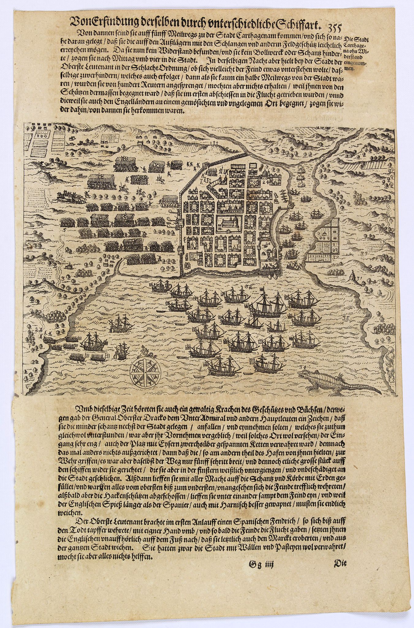
[Sir Francis Drake attacks the town of Santa Domingo.] |
||||||||||||||||||||
|
||||||||||||||||||||
|
|
||||||||||||||||||||
|
Selling price: $...
Please login to see price! Sold in 2017 Missed this item! Be the first to get notified about our newly added listings. Add your name to our mailing list. Feel free to contact us if you have a question about this item. |
Virtual Collection - Save and collect this or any of your favorite items in one place.
If you want to save the items permanently, please sign in or create account first. |
|||||||||||||||||||
Description
The town of Santo Domingo on the island of Hispaniola was once the capital of Spanish America but in 1586, when Drake arrived, it had deteriorated somewhat in stature. Because it was still the largest settlement in the West Indies, Drake chose it as his first target. He landed 10 miles west of the town and, with an army of 800 men, under the command of Commander Carleill, attacked the weakly defended town from the rear where it was almost without fortifications. The English quickly took over control of the town and ransomed it for 25,000 ducats.
In 1631 Johann Ludwig Gottfried, inherited the Theodor De Bry’s publishing firm, among the illustrated accounts of the expeditions of Magellan, Columbus, Vespucci, Cortes, Balboa, Raleigh, Drake, Smith, and many others.
Gottfried issued together with Matthaeus Merian a one-volume condensation "Newe Welt Vnd Americanische Historien/ Jnhaltende Warhafftige vnd volkommene Beschreibungen Aller West-Jndianischen Landschafften..." that used many of the original copper plates and supplemented them with new ones of more recent voyages. The book was published by Matthaeus Merian. The work was reprinted in 1655 / 1657.
More about Johann Ludwig Gottfried. [+]
Reference: www.history-engraved.org/ Hispaniola 549
FAQ - Guarantee - Shipping
Buying in the BuyNow Gallery
This item is available for immediate purchase when a "Add to Cart" or "Inquire Now" button is shown.
Items are sold in the EU margin scheme
Payments are accepted in Euros or US Dollars.
Authenticity Guarantee
 We provide professional descriptions, condition report (based on 45 years experience in the map business)
Paulus Swaen warrants the authenticity of our items and a certificate of authenticity is provided for each acquired lot.
Condition and Coloring
We indicate the condition of each item and use our unnique HiBCoR grading system in which four key items determine a map's value: Historical Importance, Beauty, Condition/Coloring and Rarity.
Color Key
We offer many maps in their original black and white condition. We do not systematically color-up maps to make them more sellable to the general public or buyer.
Copper engraved or wood block maps are always hand colored. Maps were initially colored for aesthetic reasons and to improve readability. Nowadays, it is becoming a challenge to find maps in their original colors and are therefor more valuable.
We use the following color keys in our catalog:
Original colors; mean that the colors have been applied around the time the map was issued.
Original o/l colors; means the map has only the borders colored at the time of publication.
Colored; If the colors are applied recently or at the end of the 20th century.
Read more about coloring of maps [+]
Shipping fee
A flat shipping fee of $ 30 is added to each shipment by DHL within Europe and North America. This covers : International Priority shipping, Packing and Insurance (up to the invoice amount).
Shipments to Asia are $ 40 and rest of the world $50
We charge only one shipping fee when you have been successful on multiple items or when you want to combine gallery and auction purchases.
Read more about invoicing and shipping
FAQ
Please have a look for more information about buying in the BuyNow gallery
Many answers are likely to find in the general help section.
Virtual Collection
![]()
With Virtual Collection you can collect all your favorite items in one place. It is free, and anyone can create his or her Virtual map collection.
Unless you are logged in, the item is only saved for this session. You have to be registed and logged-in if you want to save this item permanently to your Virtual Collection.
Read More[+]
Register here, it is free and you do not need a credit card.
Add this item to
Virtual Collection
or click the following link to see my Virtual Collection.
| Digital Image Download | |
|
Paulus Swaen maintains an archive of most of our high-resolution rare maps, prints, posters and medieval manuscript scans. We make them freely available for download and study. Read more about free image download |
Click the image for a free small image download. |
![Rare, antique map of [Sir Francis Drake attacks the town of Santa Domingo.]](/uploads/40367.jpg)
In accordance with the EU Consumer Rights Directive and habitually reside in the European Union you have the right to cancel the contract for the purchase of a lot, without giving any reason.
The cancellation period will expire 14 calendar days from the day after the date on which you or a third party (other than the carrier and indicated by you) acquires, physical possession of the lot. To exercise the right to cancel you must inform Paulus Swaen Inc, of your decision to cancel this contract by a clear statement (e.g. a letter sent by post, or e-mail (amsterdam@swaen.com).
To meet the cancellation deadline, it is sufficient for you to send your communication concerning your exercise of the right to cancel before the cancellation period has expired.
