Subscribe to be notified if similar examples become available.
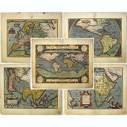
Set of world & four continents in stunning original colors. |
||||||||||||||||||||
|
||||||||||||||||||||
|
|
||||||||||||||||||||
|
Selling price: $ Please login to see price!
Sold in 2023 Missed this item! Add your name to our mailing list and be the first to get notified about our newly added listings. . |
My Collection +
Add this or any of your favorite items in one place. If you want to save the items permanently, you have to sign in or create an account first.
Watchers:
17
|
|||||||||||||||||||
Description
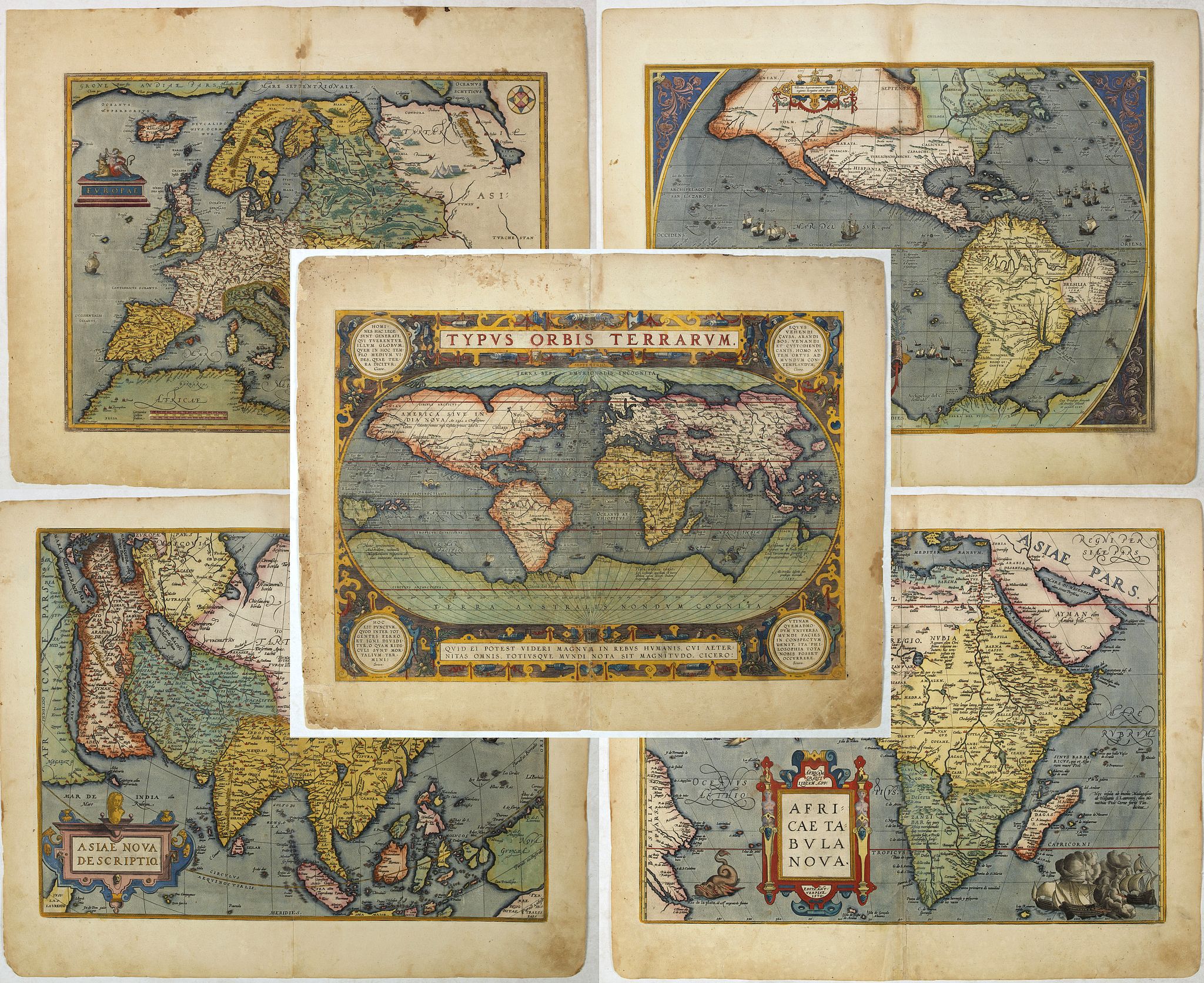
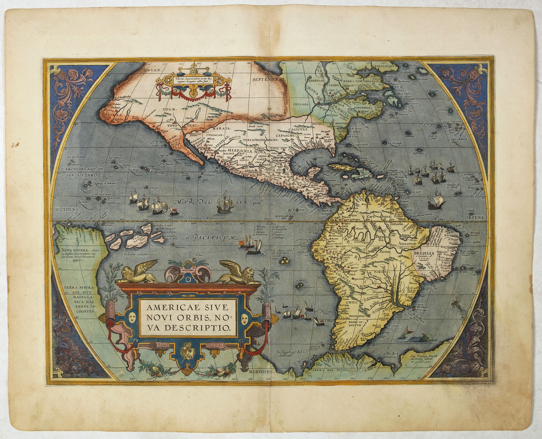
An attractive set of these decorative and important maps published at Antwerp in Ortelius' Theatrum. The Theatrum was the first large modern atlas and was extremely influential. The world and four continent maps offered here summarize in a decorative but powerful way the level of geographical knowledge at the end of the sixteenth century and the mastery of the art which expressed it on paper. These five maps are the most sought after combination of maps in the Theatrum.
The maps are in a strictly contemporary coloring and of the highest level.
More about coloring of maps! Read more [+]
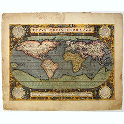
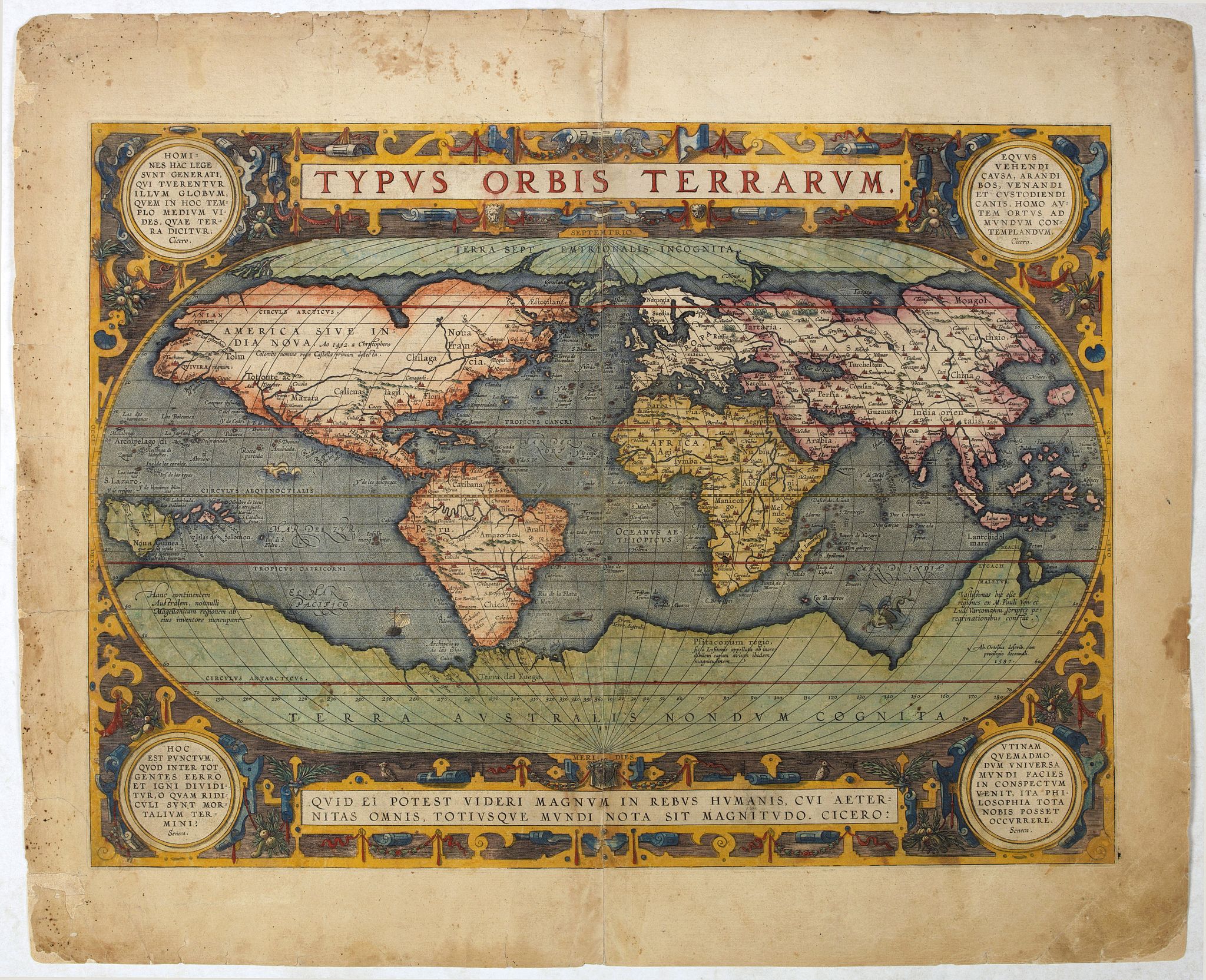
Ortelius' third world map, here an Latin edition from 1595. Oval shaped map with medallions in the four corners citing Cicero and Seneca. Updated with the more correct shape of South America and the first depiction of the Solomon Islands off the coast of a strangely shaped New Guinea. North America with a lengthy St. Lawrence River, and the lands of Anian Regnum and Quivira noted.
The Atlantic Ocean is filled with phantom islands, including Frieslant, St. Brandain, Brasil and several others.
A huge Terra Australis Nondum Cognita incorporates Tierra del Fuego, and the mythical lands of Beach, Maletur and Lucach. Japan and South East Asia with strange shapes.
Richly decorated with flying fish, sea monsters, sailing ships, and old hand coloring. A beautiful and highly influential map!
In 1587, a new plate was engraved which appeared in editions from 1588 onwards. Of the three maps, this one is perhaps the most important. It is the most geographically advanced one, with the bulge in Chile removed, the Salomon Islands inserted and additional names, including C.Mendocino, added to the north west coast. Furthermore, this is the only one of the three plates which is signed by Ortelius as responsible for the preparation of the map. Ref. : Broecke, Ortelius 11.: Burden 64.
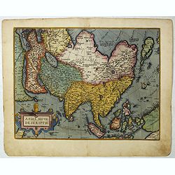
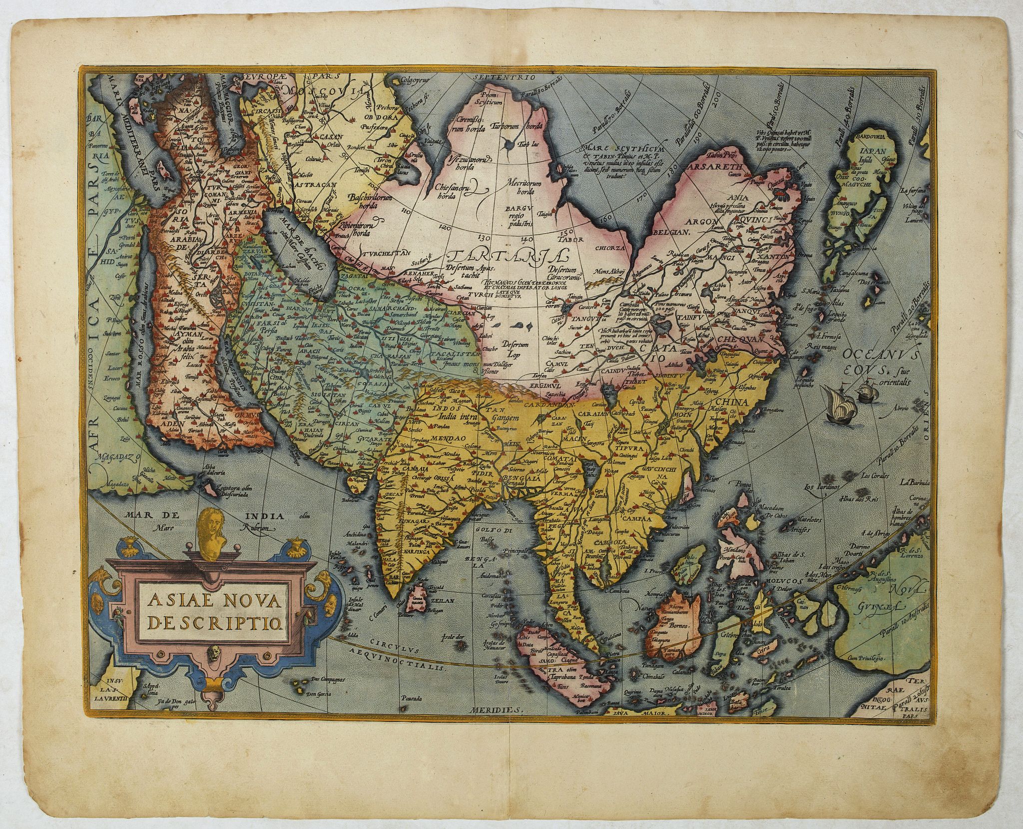
Ortelius' important map of Asia based on his wall map of 1567, which was based on the work of Gastaldi.
The cordiform projection shows Asia extended too far to the east, an error started with Ptolemy. Shape of Japan taken from Jesuit sources. Luzon is absent from the Philippines and the mythical lake Cayamay lacus is located in southern China. Great number of islands in the East Indies, but they are not well placed, due to the secrecy of voyages to the region. A portion of New Guinea and the Terrae Incognitae Australis pars is located at the right corner. Printed from the second plate, without privilege in lower left corner and small alterations. Ref. Van den Broecke, Ort. 7.
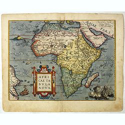
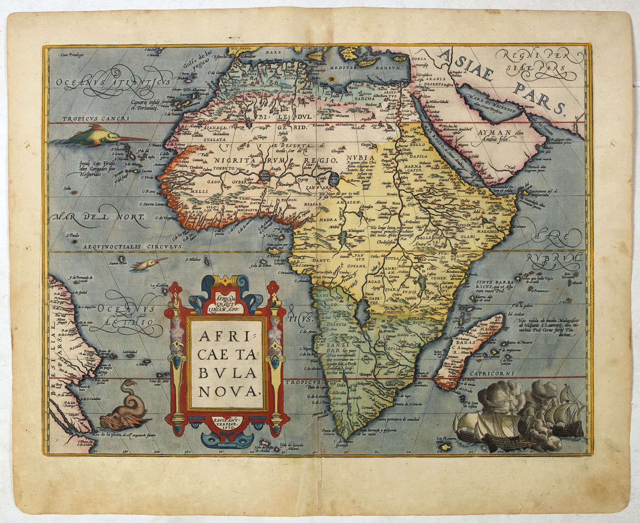
Important early map of Africa. Somewhat distorted land masses: vignette of Europe being carried off by the bull (Zeus). The second plate with title AFRICAE PARS now in Italic lettering.
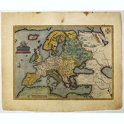
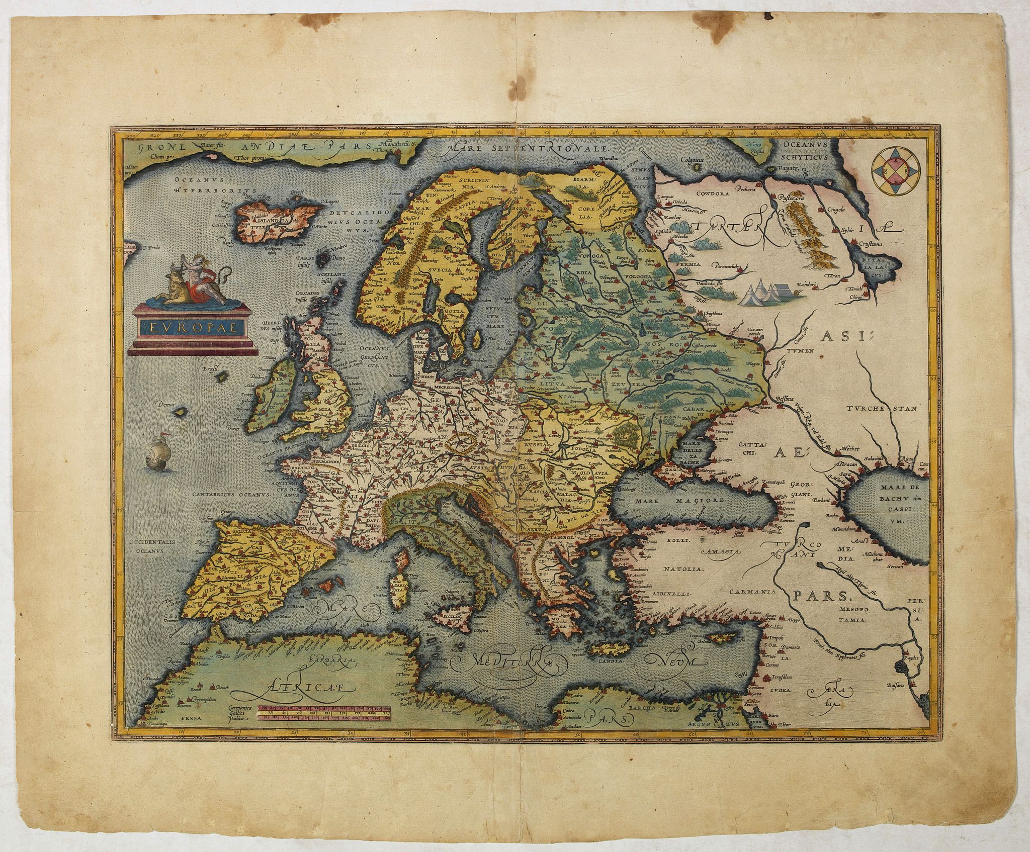
The map of Europe is based upon several important maps of Europe, including Gerard Mercator's 1554 map of Europe. Scandinavia is drawn from Olaus Magnus' 1539 Scandinavia map.
Russia is based on Jenkinson's 1562 Russia map. Ortelius himself mentions in his "Catalogus Auctorum" the maps of Apianus, Cornelius Antonii of Frankfurt, Ioannes Bucius Aenicola of Paris, Jacob Homem Lusitanus printed in Venice, Ioannes Dominicus Methoneus of Venice, Nicolaus Nicolay printed in Antwerp by Ioannes Stelsium, Vopelius, Waldseemüller, and Christoph Zell of Nurnberg.

FAQ - Guarantee - Shipping
994 BuyBidBuying in the BuyNow Gallery
This item is available for immediate purchase when a "Add to Cart" or "Inquire Now" button is shown.
Payments are accepted in Euros or US Dollars. We accept most major credit cards, PayPal and bank transfer.
Authenticity Guarantee
 We provide professional descriptions, condition report and HiBCoR rating (based on 45 years experience in the map business)
We fully guarantee the authenticity of items we sell. We provide a certificate of authenticity for each purchased item.
Condition / Coloring
We indicate the condition of each item and use our unnique HiBCoR grading system in which four key items determine a map's value: Historical Importance, Beauty, Condition/Coloring and Rarity.
We offer many maps in their original black and white condition. We do not systematically color-up maps to make them more sellable to the general public or buyer.
Copper engraved or wood block maps are always hand colored. Maps were initially colored for aesthetic reasons and to improve readability. Nowadays, it is becoming a challenge to find maps in their original colors and are therefor more valuable.
We use the following color keys in our catalog:
Original colors; mean that the colors have been applied around the time the map was issued.
Colored; If the colors are applied recently or at the end of the 20th century, then "colored", or "attractive colors" will be used.
Original o/l colors; means the map has only the borders colored at the time of publication.
Read more about coloring of maps [+]
FAQ
Please have a look for more information about buying in the BuyNow gallery.
Many answers are likely to find in the general help section.
My Collection+
![]()
With My Collection+ you can collect all your favorite items in one place. It is free, and anyone can create his or her virtual map collection.
Unless you are logged in, the item is only saved for this session. You have to be registed and logged-in if you want to save this item permanently to My Collection+.
Read More [+]
If you want to save the items permanently, please sign in
or create account first. ![]()
Registering Here, it is and you do not need a credit card.
Add this item to
My Collection+
or click the following link to see My Collection+.
Invoice
The invoice and certificates of authenticity are available in the client center >Invoices
| Digital Image Download | |
|
Paulus Swaen maintains an archive of most of our high-resolution rare maps, prints, posters and medieval manuscript scans. We make them freely available for download and study. Read more about free image download |
Click the image for a free small image download. |
In accordance with the EU Consumer Rights Directive and habitually reside in the European Union you have the right to cancel the contract for the purchase of a lot, without giving any reason.
The cancellation period will expire 14 calendar days from the day after the date on which you or a third party (other than the carrier and indicated by you) acquires, physical possession of the lot. To exercise the right to cancel you must inform Paulus Swaen Inc, of your decision to cancel this contract by a clear statement (e.g. a letter sent by post, or e-mail.
To meet the cancellation deadline, it is sufficient for you to send your communication concerning your exercise of the right to cancel before the cancellation period has expired.
