1478 -1490 PTOLEMY, C. - Landmark 15th-century map of Central Asia, from the monumental Rome edition of Ptolemy's Geography
Septima Asiae Tabula |
||||||||||||||||||||
|
||||||||||||||||||||
|
|
||||||||||||||||||||
$8000 / ≈ €7116
This item is available for immediate sale
|
My Collection +
Add this or any of your favorite items in one place. If you want to save the items permanently, you have to sign in or create an account first.   Add/Remove |
|||||||||||||||||||



Description
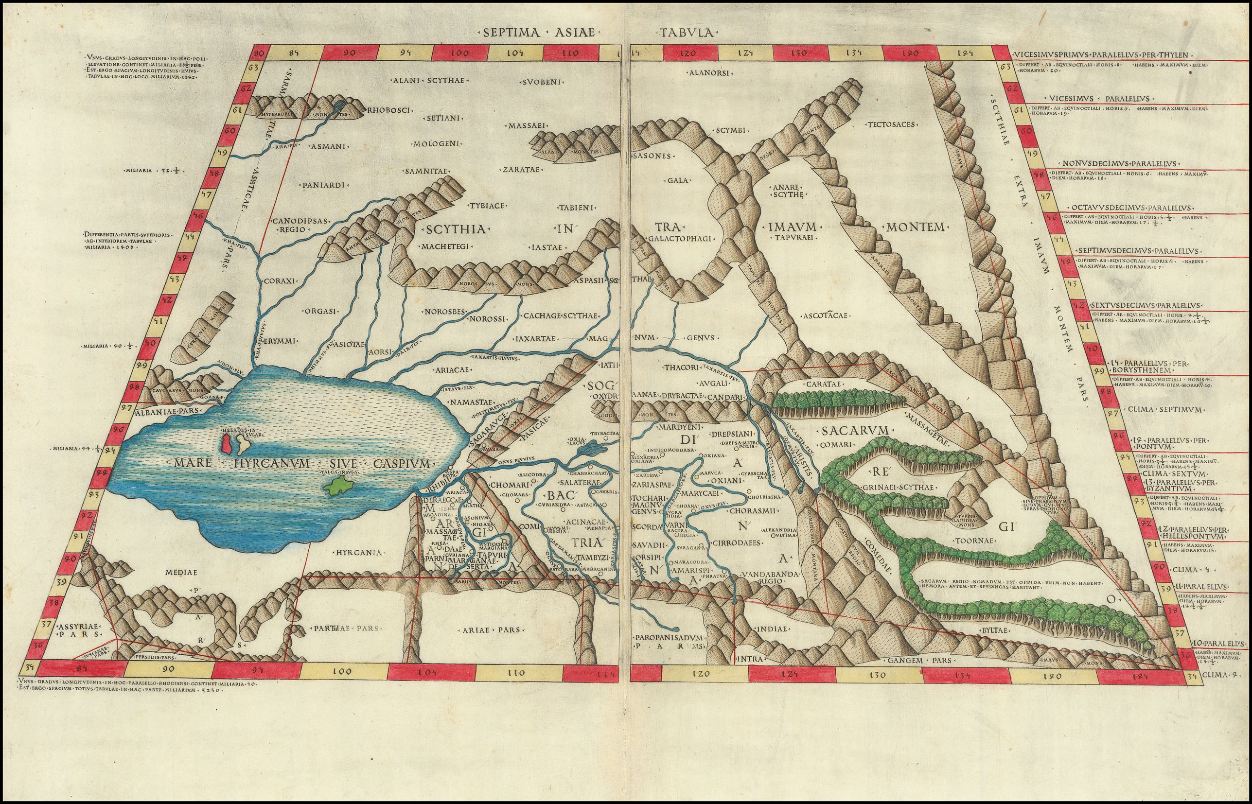
Landmark 15th-century map of Central Asia, from the monumental Rome edition of Ptolemy's Geography. One of the earliest copperplate-engraved maps.²brVery early map showing the Caspian Sea and Central Asia comes from the celebrated Rome edition of Claudius Ptolemy's Cosmographia, first published in 1478. Depicting the ancient regions of Scythia, Bactria, Sogdiana, and Margiana, the map captures the classical understanding of the lands stretching eastward toward the Himalayas. As one of the earliest printed maps to utilize copperplate engraving, it represents a watershed moment in the transmission of geographic knowledge. The Rome Ptolemy is widely regarded as one of the most magnificent achievements of incunable printing. The project was initiated circa 1473 by Conrad Sweynheym, who, alongside Arnold Pannartz, had introduced the printing press to Italy. After Sweynheym's death, Arnold Buckinck completed the work and first published it in 1478.
The present map comes from the 1490 reissue by Petrus de Turre, which used Sweynheym and Buckinck's original copperplates. Beyond its primacy as an engraved atlas, the Rome edition is celebrated for its technical ingenuity, notably Sweynheym's use of movable type punched directly into the copperplate to render the map's crisp, regular lettering.
The map presents a majestic vision of classical Central Asia based on the coordinates compiled by Ptolemy in the second century AD. The vast expanse of the Caspian Sea (Mare Hyrcanum Sive Caspium) dominates the western portion, while a complex network of sharply engraved mountain ranges, including the Caucasus and the Imaus, structures the interior. The ancient Silk Road regions of Sogdiana, Bactria, and Margiana are clearly delineated, reflecting the Hellenistic and Roman geographic conception of the known world's furthest reaches before the era of modern exploration. The map features an austere, geometric aesthetic and a trapezoidal projection (adapted from the manuscript models of Donnus Nicolaus Germanus). The attractive hand-coloring highlights the latitudinal and longitudinal borders, further emphasizing the map's mathematical foundations.
The Rome Ptolemy marked a turning point in the European recovery of classical learning. As the coordinates of Ptolemy were translated into standardized, reproducible printed images, scholars across Europe gained access to a uniform, mathematically rigorous model of the world. This map of Central Asia disseminated the geographic framework that would guide early modern encounters with the East, preserving ancient place names that had shaped European historical consciousness for over a millennium.
The Invention of Punched Lettering.
Beyond its geographic significance, the Roman Ptolemy is studied for a technical breakthrough in the history of printing. The maps in this atlas represent the first use of the punched-letter printing process for cartographic toponymy. Historically, the dense toponymy required for mapmaking demanded the time-consuming and specialized skills of an experienced lettering engraver wielding a burin. Recognizing the colossal labor required to incise thousands of names across twenty-seven maps, Sweynheym devised a semi-mechanical alternative. He utilized cast metal punches, similar to those used in his typographic press, to stamp the letters directly into the copper printing plates. This point of contact between the concurrent histories of copperplate engraving and typography established a technique that Italian mapmakers adopted widely for more than a century. The resulting typographic uniformity grants the Rome plates an aesthetic clarity that far surpassed the irregular hand-lettering found in the rival 1477 Bologna edition printed by Taddeo Crivelli.
The map was printed from the exact same unembellished copperplate for both the initial 1478 edition published by Arnold Buckinck and the subsequent 1490 edition published by Petrus de Turre. The impressions from these two Rome editions are visually identical, with no alterations to the plate itself, such as changes to the geographic content, the addition of new borders, or updated publisher imprints. The definitive distinction between the two editions relies exclusively on an intensive examination of the paper's watermark, as the bibliographic state of the copperplate remained unchanged between the two fifteenth-century printings.
Claudius Ptolemy (c. 85-165)
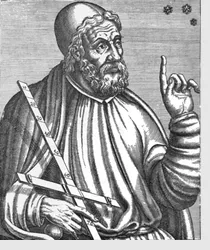 Claudius Ptolemaeus, better known as Ptolemy, was the most accomplished and influential astronomer of the ancient world, and his work dominated the field until the mid-17th century. He lived in Alexandria, Egypt. Almost nothing is known about Ptolemy's life, as historical sources from the time period are scarce. Today, Ptolemy is known almost exclusively through his work and they have influenced other thinkers over the centuries.
Ptolemy wrote his Geographia around the year 150 AD which compiled existing knowledge about the world’s geography at the time. The work refered to a system of latitude and longitude, as well as a means of describing locations on earth based on astronomical observations from those areas. Ptolemy’s original maps from the work were never found, having presumably been lost over the years, but his work was descriptive enough that cartographers were able to recreate his observations in 1300 AD, and create the Ptolemy map.
His world map is notable for its probable role in the Roman expansion. Ptolemy’s idea of using a latitude and longitude system had a significant impact on the work of later cartographers.
Astronomy
There were many accomplished Greek astronomers before Ptolemy (and many Babylonian astronomers before them), but Ptolemy stands out because he wrote a complete treatise on the principles and techniques of astronomy, and that treatise survived to be translated into Arabic and Latin and shape the course of medieval and Renaissance astronomy. Ptolemy's book is often referred to as the Almagest, from an Arabic title meaning "the greatest," i.e., the largest of his astronomical treatises.
The Almagest was translated into Arabic during the Golden Age of Islam, and later, in the medieval West, into Latin, first from Arabic, and eventually from the original Greek, when Greek manuscripts became available in the Renaissance.
FAQ - Guarantee - Shipping
This item is available for immediate purchase when a "Add to Cart" or "Inquire Now" button is shown.
Items are sold in the EU margin scheme
Payments are accepted in Euros or US Dollars.
Authenticity Guarantee
 We provide professional descriptions, condition report (based on 45 years experience in the map business)
Paulus Swaen warrants the authenticity of our items and a certificate of authenticity is provided for each acquired lot.
Condition and Coloring
We indicate the condition of each item and use our unnique HiBCoR grading system in which four key items determine a map's value: Historical Importance, Beauty, Condition/Coloring and Rarity.
Color Key
We offer many maps in their original black and white condition. We do not systematically color-up maps to make them more sellable to the general public or buyer.
Copper engraved or wood block maps are always hand colored. Maps were initially colored for aesthetic reasons and to improve readability. Nowadays, it is becoming a challenge to find maps in their original colors and are therefor more valuable.
We use the following color keys in our catalog:
Original colors; mean that the colors have been applied around the time the map was issued.
Original o/l colors; means the map has only the borders colored at the time of publication.
Colored; If the colors are applied recently or at the end of the 20th century.
Read more about coloring of maps [+]
Shipping fee
A flat shipping fee of $ 30 is added to each shipment by DHL within Europe and North America. This covers : International Priority shipping, Packing and Insurance (up to the invoice amount).
Shipments to Asia are $ 40 and rest of the world $50
We charge only one shipping fee when you have been successful on multiple items or when you want to combine gallery and auction purchases.
Read more about invoicing and shipping
FAQ
Please have a look for more information about buying in the BuyNow gallery
Many answers are likely to find in the general help section.
My Collection+

With My Collection+ you can collect all your favorite items in one place. It is free, and anyone can create his or her virtual collection.
Unless you are logged in, the item is only saved for this session. You have to be registed and logged-in if you want to save this item permanently to My Collection+. Read More[+]
Register here, it is free and you do not need a credit card.
Add this item to My Collection+ or click the following link to see My Collection+.
|
Digital Image Download Paulus Swaen maintains an archive of most of our high-resolution rare maps, prints, posters and medieval manuscript scans. We make them freely available for download and study. Read more about free image download |
Click the image for a free small image download. |
YOUR RIGHT TO CANCEL THE PURCHASE OF A LOT
In accordance with the EU Consumer Rights Directive and habitually reside in the European Union you have the right to cancel the contract for the purchase of a lot, without giving any reason.
The cancellation period will expire 14 calendar days from the day after the date on which you or a third party (other than the carrier and indicated by you) acquires, physical possession of the lot. To exercise the right to cancel you must inform Paulus Swaen Inc, of your decision to cancel this contract by a clear statement (e.g. a letter sent by post, or e-mail.
To meet the cancellation deadline, it is sufficient for you to send your communication concerning your exercise of the right to cancel before the cancellation period has expired.
