Please login to see price!.
Subscribe to be notified if similar examples become available.

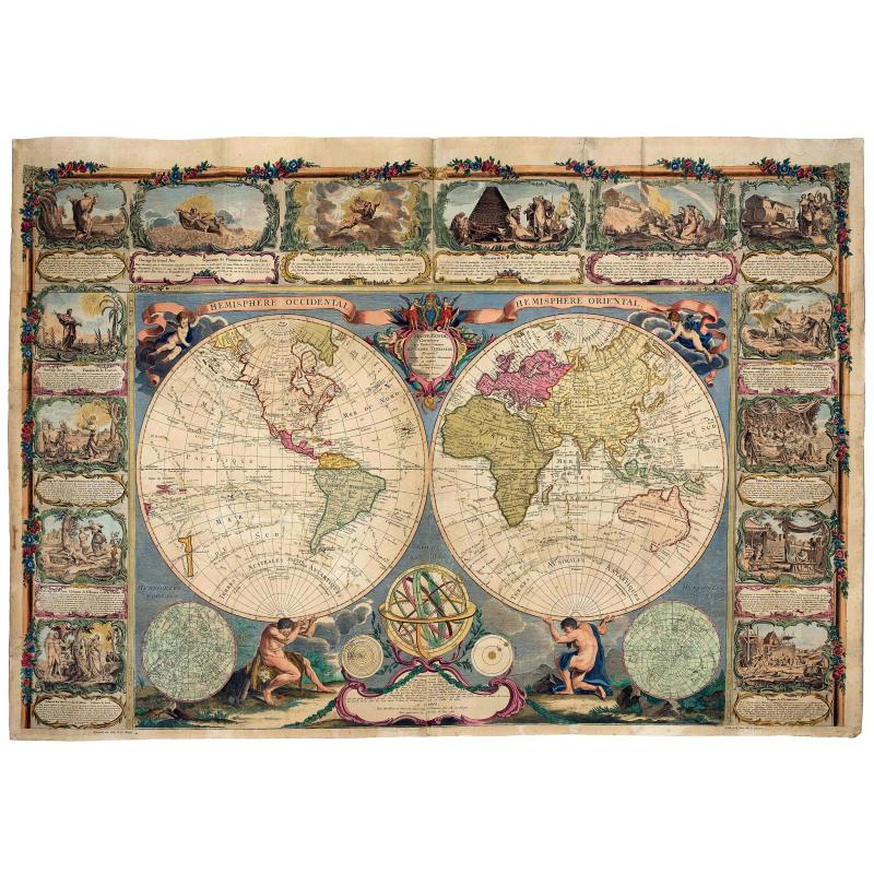
Mappe Monde, contenant les Parties Connues du Globe Terrestre |
||||||||||||||||||||
|
||||||||||||||||||||
|
|
||||||||||||||||||||
|
Selling price: $...
Please login to see price! Sold in 2021 Missed this item! Be the first to get notified about our newly added listings. Add your name to our mailing list. Feel free to contact us if you have a question about this item. |
Virtual Collection - Save and collect this or any of your favorite items in one place.
If you want to save the items permanently, please sign in or create account first. |
|||||||||||||||||||
Description
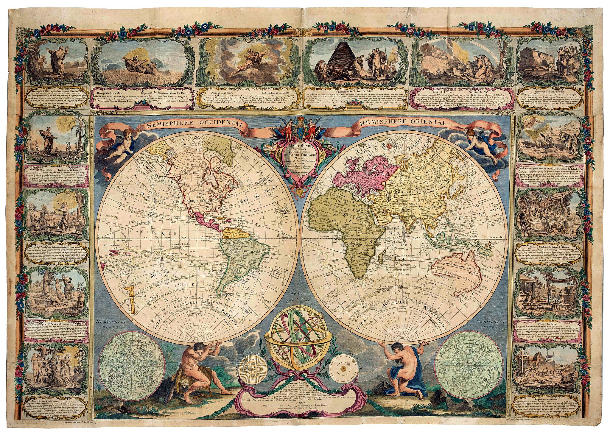
This beautiful wall map consists of two hemispheres. The Eastern Hemisphere is being carried by Hercules (with the skin of the Nemean Lion), the Western Hemisphere is carried by Atlas. At the top, title ribbons are held by putti. At the bottom left we see the starry sky from the Northern Hemisphere, in the bottom right there is the sky from the Southern Hemisphere, at the bottom in the middle a so-called armillary sphere in which we see the celestial sphere with the main topics, as well as images of the Ptolemaic geocentric world system (in which the earth is at the center and surrounded by the planets) and the Copernican system (in which the earth is only one of the planets of our solar system).
The map is framed on three sides.
There are vignettes with a Biblical story of Creation from first to the sixth day starting in the top center, and ending anti-clockwise in the lower-left corner with Adam and Eve in Paradise.
Starting at top right and continuing in the right border there are seven vignettes showing the Tower of Babel, Arch of Noah and manners of activities.
NOTE: Lacking the lower banner with two textural vignettes about the history of geography from ancient and modern history and three other vignettes.
Dated in lower part, 1788. This is a heavenly updated version of Jean Janvier / Longchamps edition of 1754. The northwest coast of America is largely conjectured with the information largely derived from Russian sources (1731/1732) and James Cook (1778/1779). The coast has no longer the fanciful "Mer de l'Quest". The 3rd voyage of James Cook, Willis, and Bouganville (1768) are shown.
In the interior of North America, we find a Lac de Fonte connected to a series of lakes.
The east coast of Australia is no longer connected to New Guinea and its east coast is now continued to Tasmania.
FAQ - Guarantee - Shipping
Buying in the BuyNow Gallery
This item is available for immediate purchase when a "Add to Cart" or "Inquire Now" button is shown.
Items are sold in the EU margin scheme
Payments are accepted in Euros or US Dollars.
Authenticity Guarantee
 We provide professional descriptions, condition report (based on 45 years experience in the map business)
Paulus Swaen warrants the authenticity of our items and a certificate of authenticity is provided for each acquired lot.
Condition and Coloring
We indicate the condition of each item and use our unnique HiBCoR grading system in which four key items determine a map's value: Historical Importance, Beauty, Condition/Coloring and Rarity.
Color Key
We offer many maps in their original black and white condition. We do not systematically color-up maps to make them more sellable to the general public or buyer.
Copper engraved or wood block maps are always hand colored. Maps were initially colored for aesthetic reasons and to improve readability. Nowadays, it is becoming a challenge to find maps in their original colors and are therefor more valuable.
We use the following color keys in our catalog:
Original colors; mean that the colors have been applied around the time the map was issued.
Original o/l colors; means the map has only the borders colored at the time of publication.
Colored; If the colors are applied recently or at the end of the 20th century.
Read more about coloring of maps [+]
Shipping fee
A flat shipping fee of $ 30 is added to each shipment by DHL within Europe and North America. This covers : International Priority shipping, Packing and Insurance (up to the invoice amount).
Shipments to Asia are $ 40 and rest of the world $50
We charge only one shipping fee when you have been successful on multiple items or when you want to combine gallery and auction purchases.
Read more about invoicing and shipping
FAQ
Please have a look for more information about buying in the BuyNow gallery
Many answers are likely to find in the general help section.
Virtual Collection
![]()
With Virtual Collection you can collect all your favorite items in one place. It is free, and anyone can create his or her Virtual map collection.
Unless you are logged in, the item is only saved for this session. You have to be registed and logged-in if you want to save this item permanently to your Virtual Collection.
Read More[+]
Register here, it is free and you do not need a credit card.
Add this item to
Virtual Collection
or click the following link to see my Virtual Collection.
| Digital Image Download | |
|
Paulus Swaen maintains an archive of most of our high-resolution rare maps, prints, posters and medieval manuscript scans. We make them freely available for download and study. Read more about free image download |
Click the image for a free small image download. |
In accordance with the EU Consumer Rights Directive and habitually reside in the European Union you have the right to cancel the contract for the purchase of a lot, without giving any reason.
The cancellation period will expire 14 calendar days from the day after the date on which you or a third party (other than the carrier and indicated by you) acquires, physical possession of the lot. To exercise the right to cancel you must inform Paulus Swaen Inc, of your decision to cancel this contract by a clear statement (e.g. a letter sent by post, or e-mail (amsterdam@swaen.com).
To meet the cancellation deadline, it is sufficient for you to send your communication concerning your exercise of the right to cancel before the cancellation period has expired.

