Subscribe to be notified if similar examples become available.
![[Leo Belgicus.]](/uploads/cache/49042-250x250.jpg)
![[Leo Belgicus.]](/uploads/cache/49042A-250x250.jpg)
[Leo Belgicus.] |
||||||||||||||||||||
|
||||||||||||||||||||
|
|
||||||||||||||||||||
Description
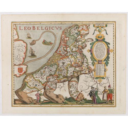
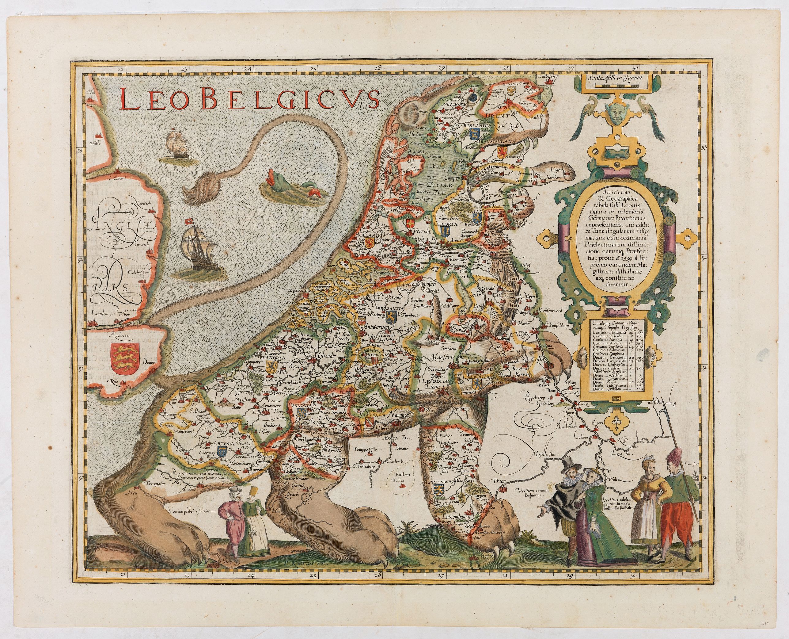
Among the greatest decorative works of early cartography is a series of arresting maps showing The Netherlands and Belgium in the shape of a lion. The various versions of these so-called Leo Belgicus maps are all exceedingly rare, only a few examples surviving and in some cases only a solitary specimen has been located. This particular example by Kaerius is one of the most decorative.
The use of the shape of a lion in the depiction of the two countries arose in part from the fact that their actual shape is vaguely leonine. This commanding image was an apt symbol for a nation on the verge of unprecedented wealth and power. Secondly, the lion had long figured in the national iconography of the area: most of the coats-of-arms of the 17 provinces of the countries feature a lion.
Â
Also, the map was a statement of unity, since at the time the 17 provinces comprised a single nation, although under the yoke of Spanish domination. Its rich ornamentation includes three couples along the bottom in the characteristic dress of the regions of Friesland, Holland and Belgium.
Reference: Van der Heijden, Leo Belgicus 4.2.a.
FAQ - Guarantee - Shipping
Buying in the BuyNow Gallery
This item is available for immediate purchase when a "Add to Cart" or "Inquire Now" button is shown.
Payments are accepted in Euros or US Dollars. We accept most major credit cards, PayPal and bank transfer.
Authenticity Guarantee
 We provide professional descriptions, condition report and HiBCoR rating (based on 45 years experience in the map business)
We fully guarantee the authenticity of items we sell. We provide a certificate of authenticity for each purchased item.
Condition / Coloring
We indicate the condition of each item and use our unnique HiBCoR grading system in which four key items determine a map's value: Historical Importance, Beauty, Condition/Coloring and Rarity.
We offer many maps in their original black and white condition. We do not systematically color-up maps to make them more sellable to the general public or buyer.
Copper engraved or wood block maps are always hand colored. Maps were initially colored for aesthetic reasons and to improve readability. Nowadays, it is becoming a challenge to find maps in their original colors and are therefor more valuable.
We use the following color keys in our catalog:
Original colors; mean that the colors have been applied around the time the map was issued.
Colored; If the colors are applied recently or at the end of the 20th century, then "colored", or "attractive colors" will be used.
Original o/l colors; means the map has only the borders colored at the time of publication.
Read more about coloring of maps [+]
FAQ
Please have a look for more information about buying in the BuyNow gallery.
Many answers are likely to find in the general help section.
Virtual Collection
![]()
With Virtual Collection you can collect all your favorite items in one place. It is free, and anyone can create his or her Virtual map collection.
Unless you are logged in, the item is only saved for this session. You have to be registed and logged-in if you want to save this item permanently to your Virtual Collection.
Read More [+]
If you want to save the items permanently, please sign in
or create account first. ![]()
Registering Here, it is and you do not need a credit card.
Add this item to
Virtual Collection
or click the following link to see my Virtual Collection.
Invoice
The invoice and certificates of authenticity are available in the client center >Invoices
| Digital Image Download | |
|
Paulus Swaen maintains an archive of most of our high-resolution rare maps, prints, posters and medieval manuscript scans. We make them freely available for download and study. Read more about free image download |
Click the image for a free small image download. |
![Rare, antique map of [Leo Belgicus.]](/uploads/49042.jpg)
![Rare, antique map of [Leo Belgicus.]](/uploads/49042A.jpg)
In accordance with the EU Consumer Rights Directive and habitually reside in the European Union you have the right to cancel the contract for the purchase of a lot, without giving any reason.
The cancellation period will expire 14 calendar days from the day after the date on which you or a third party (other than the carrier and indicated by you) acquires, physical possession of the lot. To exercise the right to cancel you must inform Paulus Swaen Inc, of your decision to cancel this contract by a clear statement (e.g. a letter sent by post, or e-mail (amsterdam@swaen.com).
To meet the cancellation deadline, it is sufficient for you to send your communication concerning your exercise of the right to cancel before the cancellation period has expired.
