Please login to see price!.
Subscribe to be notified if similar examples become available.

![LE TOUR DU MONDE EN UN CLIN DE OEIL [‘Around the World in a Wink']](/uploads/cache/85141-800x800.jpg)
LE TOUR DU MONDE EN UN CLIN DE OEIL [‘Around the World in a Wink'] |
||||||||||||||||||||
|
||||||||||||||||||||
|
|
||||||||||||||||||||
|
Selling price: $...
Please login to see price! Sold in 2021 Missed this item! Be the first to get notified about our newly added listings. Add your name to our mailing list. Feel free to contact us if you have a question about this item. |
Virtual Collection - Save and collect this or any of your favorite items in one place.
If you want to save the items permanently, please sign in or create account first. |
|||||||||||||||||||
Description
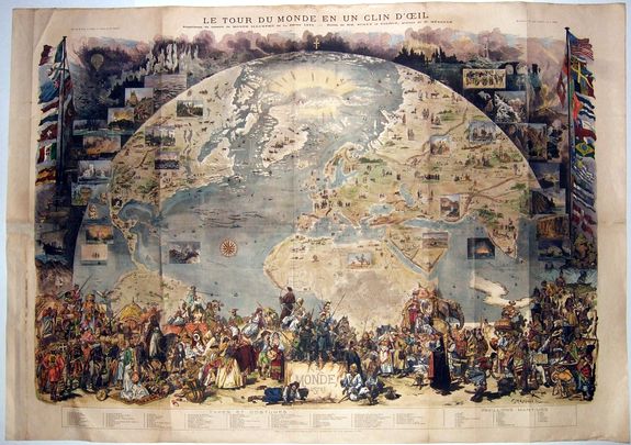
Spectacular view of the World with pictorial illustration.
Extra large wooden graved, highly decorative World map, with flags of major nations ,views ,costumes ,economic information - local products [Opium in China for example] , recent explorations - mostly in Africa and the Arctic, some railroads, plants and animals, famous antiques and nature sites, etc.
At the base of the map a large key with around 100 entries.At the top of the world a small cross with the Greek letters Alpha and Omega...
Issued as supplement to 'Le Monde Illustré' ,January 1st 1876.
Although the map was issued in a large Quantity, it's rarely found. - Because of its large size, its thin fragile paper and use as decoration in the time of issue [like most wall maps].
At the base of the map a large key with around 100 entries.
Note:
Pictorial view of the world. Originally issued uncolored, color was added later. Map is projected as a view from space and details the world roughly from the Equator to the North Pole and from California to India. Flora, fauna, historic events, cultural artefacts, and indigenous people are represented pictorially. The Sargasso Sea is illustrated in the middle of the Atlantic. Includes inset views illustrate places and moments of special interest including mirages in the Pacific, a ship burning at sea, Niagara Falls, Chicago, oil wells, gold mining, Hindu cremation, Chinese Junks, Tuareg warriors, an avalanche, etc. also includes lists of the nations and maritime flags. Shows sketches of some 79 individuals in 'traditional costumes'. To either side of the main view are flags of major nations, sailing ships, volcanoes, and other imagery. Include an ice free polar sea north of Greenland labelled 'Mer Libre?' No doubt this is a nod to hopes that a Northwest Passage might still exist. [Seems mostly to have been achieved now through the relentless work of humanity!] Union Pacific and Trans-Atlantic shipping lanes are noted. The achievements of various explorers are noted in both Africa and the Arctic.
The map tells a non-linear story and invites readers to explore the different parts of the world. It’s also an example of innovation and ingenuity in cartography since the map includes what appear to be photographs yet this was published in a time when photographic reproduction in print wasn’t technically possible. Instead, the solution was to create a wood-engraved version of the images in such detail that they take on the appearance of a photograph.
Extra large wooden graved, highly decorative World map, with flags of major nations ,views ,costumes ,economic information - local products [Opium in China for example] , recent explorations - mostly in Africa and the Arctic, some railroads, plants and animals, famous antiques and nature sites, etc.
At the base of the map a large key with around 100 entries.At the top of the world a small cross with the Greek letters Alpha and Omega...
Issued as supplement to 'Le Monde Illustré' ,January 1st 1876.
Although the map was issued in a large Quantity, it's rarely found. - Because of its large size, its thin fragile paper and use as decoration in the time of issue [like most wall maps].
At the base of the map a large key with around 100 entries.
Note: Pictorial view of the world. Originally issued uncolored, color was added later. Map is projected as a view from space and details the world roughly from the Equator to the North Pole and from California to India. Flora, fauna, historic events, cultural artefacts, and indigenous people are represented pictorially. The Sargasso Sea is illustrated in the middle of the Atlantic. Includes inset views illustrate places and moments of special interest including mirages in the Pacific, a ship burning at sea, Niagara Falls, Chicago, oil wells, gold mining, Hindu cremation, Chinese Junks, Tuareg warriors, an avalanche, etc. also includes lists of the nations and maritime flags. Shows sketches of some 79 individuals in 'traditional costumes'. To either side of the main view are flags of major nations, sailing ships, volcanoes, and other imagery. Include an ice free polar sea north of Greenland labelled 'Mer Libre?' No doubt this is a nod to hopes that a Northwest Passage might still exist. [Seems mostly to have been achieved now through the relentless work of humanity!] Union Pacific and Trans-Atlantic shipping lanes are noted. The achievements of various explorers are noted in both Africa and the Arctic.
The map tells a non-linear story and invites readers to explore the different parts of the world. It’s also an example of innovation and ingenuity in cartography since the map includes what appear to be photographs yet this was published in a time when photographic reproduction in print wasn’t technically possible. Instead, the solution was to create a wood-engraved version of the images in such detail that they take on the appearance of a photograph.
FAQ - Guarantee - Shipping
Buying in the BuyNow Gallery
This item is available for immediate purchase when a "Add to Cart" or "Inquire Now" button is shown.
Items are sold in the EU margin scheme
Payments are accepted in Euros or US Dollars.
Authenticity Guarantee
 We provide professional descriptions, condition report (based on 45 years experience in the map business)
Paulus Swaen warrants the authenticity of our items and a certificate of authenticity is provided for each acquired lot.
Condition and Coloring
We indicate the condition of each item and use our unnique HiBCoR grading system in which four key items determine a map's value: Historical Importance, Beauty, Condition/Coloring and Rarity.
Color Key
We offer many maps in their original black and white condition. We do not systematically color-up maps to make them more sellable to the general public or buyer.
Copper engraved or wood block maps are always hand colored. Maps were initially colored for aesthetic reasons and to improve readability. Nowadays, it is becoming a challenge to find maps in their original colors and are therefor more valuable.
We use the following color keys in our catalog:
Original colors; mean that the colors have been applied around the time the map was issued.
Original o/l colors; means the map has only the borders colored at the time of publication.
Colored; If the colors are applied recently or at the end of the 20th century.
Read more about coloring of maps [+]
Shipping fee
A flat shipping fee of $ 30 is added to each shipment by DHL within Europe and North America. This covers : International Priority shipping, Packing and Insurance (up to the invoice amount).
Shipments to Asia are $ 40 and rest of the world $50
We charge only one shipping fee when you have been successful on multiple items or when you want to combine gallery and auction purchases.
Read more about invoicing and shipping
FAQ
Please have a look for more information about buying in the BuyNow gallery
Many answers are likely to find in the general help section.
Virtual Collection
![]()
With Virtual Collection you can collect all your favorite items in one place. It is free, and anyone can create his or her Virtual map collection.
Unless you are logged in, the item is only saved for this session. You have to be registed and logged-in if you want to save this item permanently to your Virtual Collection.
Read More[+]
Register here, it is free and you do not need a credit card.
Add this item to
Virtual Collection
or click the following link to see my Virtual Collection.
| Digital Image Download | |
|
Paulus Swaen maintains an archive of most of our high-resolution rare maps, prints, posters and medieval manuscript scans. We make them freely available for download and study. Read more about free image download |
Click the image for a free small image download. |
![Rare, antique map of LE TOUR DU MONDE EN UN CLIN DE OEIL [‘Around the World in a Wink']](/uploads/85141.jpg)
In accordance with the EU Consumer Rights Directive and habitually reside in the European Union you have the right to cancel the contract for the purchase of a lot, without giving any reason.
The cancellation period will expire 14 calendar days from the day after the date on which you or a third party (other than the carrier and indicated by you) acquires, physical possession of the lot. To exercise the right to cancel you must inform Paulus Swaen Inc, of your decision to cancel this contract by a clear statement (e.g. a letter sent by post, or e-mail (amsterdam@swaen.com).
To meet the cancellation deadline, it is sufficient for you to send your communication concerning your exercise of the right to cancel before the cancellation period has expired.
