Subscribe to be notified if similar examples become available.
L'Asie En Plusieurs Cartes Nouvelles. . . |
||||||||||||||||||||
|
||||||||||||||||||||
|
|
||||||||||||||||||||
|
Selling price: $ Please login to see price!
Sold in 2017 Missed this item! Add your name to our mailing list and be the first to get notified about our newly added listings. . |
My Collection + - Save and collect this or any of your favorite items in one place.
If you want to save the items permanently, please sign in or create account first. |
|||||||||||||||||||
Description
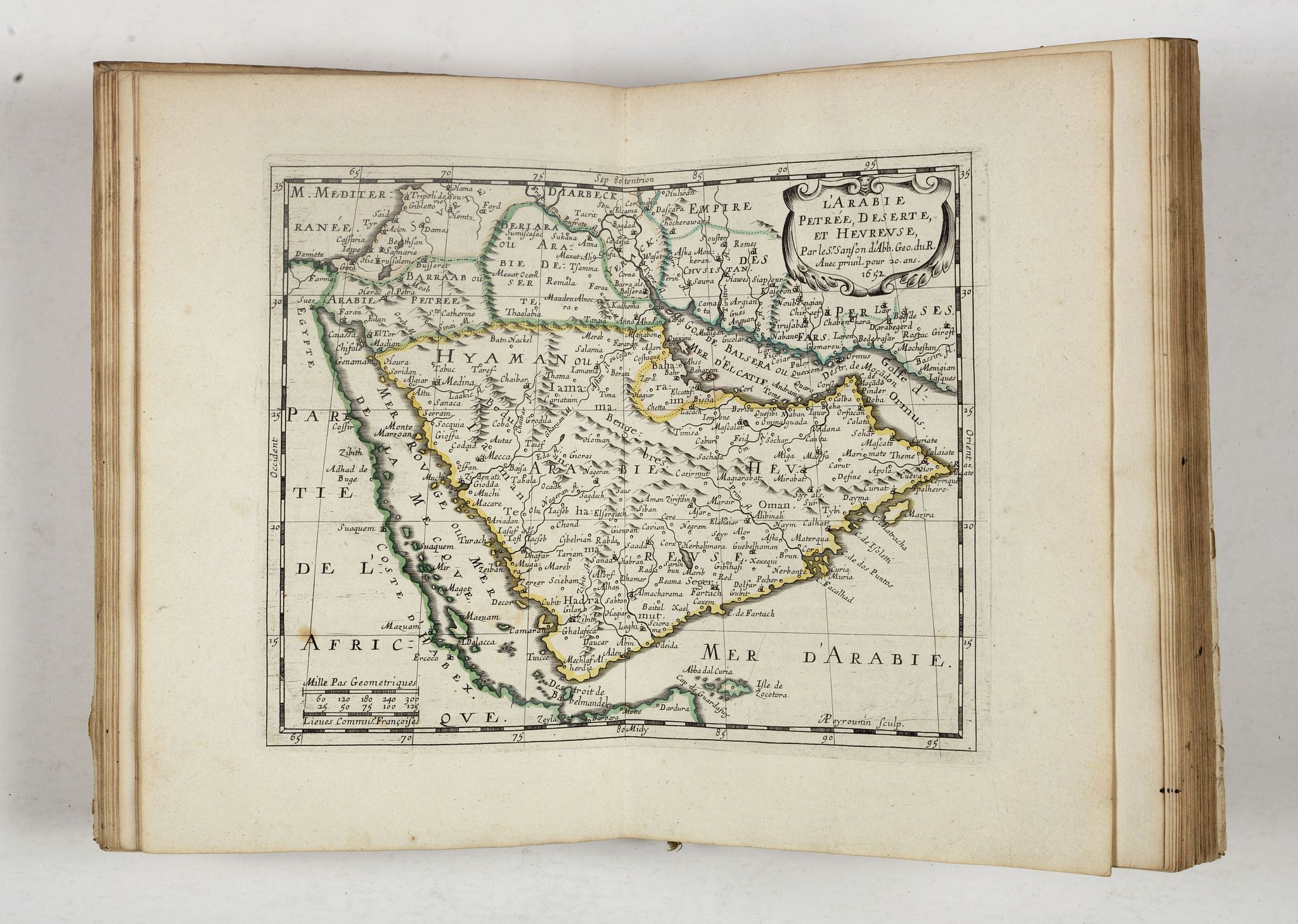
Apparently an unknown variant, maybe a state between 1652 and 1662. The title-page bears the date of the first edition (1652), the address of the second edition (B) misspelt “Cioistre” instead of “Cloistre”, no mention of second edition and no dedication to Foucquet.
The maps are: L'Asie, Turquie en Asie, Anatolie, Sorie, Turcomanie Georgie Commanie, L'Arabie, L'Empire du Sophy, L'Empire du Grand Mogol, Presqu'Isle de l'Inde deca la Gange, Partie de l'Inde audela du Gange, Royaume de la Chine, La Grande Tartarie, Description des Isles du Japon, Les Isles Philippines, Les Isles Molucques, Les Isles de la Sonde, and Ceylan et les Maldives.
Furthermore the atlas includes 10 additional maps of antique Asia engraved by Lhuillier and AB de la Place.
The first atlases published by Sanson, a pioneer in atlas production and in making cartography a science, were quarto atlases of the continents. Most of the maps are engraved especially for these works and are not reductions of larger previously published maps. The first edition included 17 maps, this edition includes 10 additional maps of antique Asia dated 1654 and 1655. One of them “Asia minor” by Nicolas II Sanson and engraved by AB de la Place, is one of the few maps produced by Nicolas II Sanson who died in 1648. Since Sanson was the first French cartographer to have access to Jesuit surveys just then emerging from China, his work provided fresh information.
Some of the 27 maps in this atlas are maps of Japan and Korea, the Philippines.
The map of Arabia depicting Bahrain spelt “Baharem” (The Gulf in Historic Maps 1493-1931, edited by Sultan Bin Muhammad Al-Qasimi Phd : 1652, N. Sanson, L’Arabie Petrée, Deserte, et Heureuse).
Reference: Pastoureau, Les atlas français XVIe-XVIIe siècles, Sanson III A and C, variant.
FAQ - Guarantee - Shipping
Buying in the BuyNow Gallery
This item is available for immediate purchase when a "Add to Cart" or "Inquire Now" button is shown.
Items are sold in the EU margin scheme
Payments are accepted in Euros or US Dollars.
Authenticity Guarantee
 We provide professional descriptions, condition report (based on 45 years experience in the map business)
Paulus Swaen warrants the authenticity of our items and a certificate of authenticity is provided for each acquired lot.
Condition and Coloring
We indicate the condition of each item and use our unnique HiBCoR grading system in which four key items determine a map's value: Historical Importance, Beauty, Condition/Coloring and Rarity.
Color Key
We offer many maps in their original black and white condition. We do not systematically color-up maps to make them more sellable to the general public or buyer.
Copper engraved or wood block maps are always hand colored. Maps were initially colored for aesthetic reasons and to improve readability. Nowadays, it is becoming a challenge to find maps in their original colors and are therefor more valuable.
We use the following color keys in our catalog:
Original colors; mean that the colors have been applied around the time the map was issued.
Original o/l colors; means the map has only the borders colored at the time of publication.
Colored; If the colors are applied recently or at the end of the 20th century.
Read more about coloring of maps [+]
Shipping fee
A flat shipping fee of $ 30 is added to each shipment by DHL within Europe and North America. This covers : International Priority shipping, Packing and Insurance (up to the invoice amount).
Shipments to Asia are $ 40 and rest of the world $50
We charge only one shipping fee when you have been successful on multiple items or when you want to combine gallery and auction purchases.
Read more about invoicing and shipping
FAQ
Please have a look for more information about buying in the BuyNow gallery
Many answers are likely to find in the general help section.
My Collection+
![]()
With My Collection+ you can collect all your favorite items in one place. It is free, and anyone can create his or her virtual collection.
Unless you are logged in, the item is only saved for this session. You have to be registed and logged-in if you want to save this item permanently to My Collection+.
Read More[+]
Register here, it is free and you do not need a credit card.
Add this item to
My Collection+
or click the following link to see My Collection+.
| Digital Image Download | |
|
Paulus Swaen maintains an archive of most of our high-resolution rare maps, prints, posters and medieval manuscript scans. We make them freely available for download and study. Read more about free image download |
Click the image for a free small image download. |
In accordance with the EU Consumer Rights Directive and habitually reside in the European Union you have the right to cancel the contract for the purchase of a lot, without giving any reason.
The cancellation period will expire 14 calendar days from the day after the date on which you or a third party (other than the carrier and indicated by you) acquires, physical possession of the lot. To exercise the right to cancel you must inform Paulus Swaen Inc, of your decision to cancel this contract by a clear statement (e.g. a letter sent by post, or e-mail (amsterdam@swaen.com).
To meet the cancellation deadline, it is sufficient for you to send your communication concerning your exercise of the right to cancel before the cancellation period has expired.
