Subscribe to be notified if similar examples become available.
Insula Quae a Ioanne Mayen Nomen Sortita Est. |
||||||||||||||||||||
|
||||||||||||||||||||
|
|
||||||||||||||||||||
|
Selling price: $ Please login to see price!
Sold in 2023 Missed this item! Add your name to our mailing list and be the first to get notified about our newly added listings. . |
My Collection + - Save and collect this or any of your favorite items in one place.
If you want to save the items permanently, please sign in or create account first. |
|||||||||||||||||||
Description
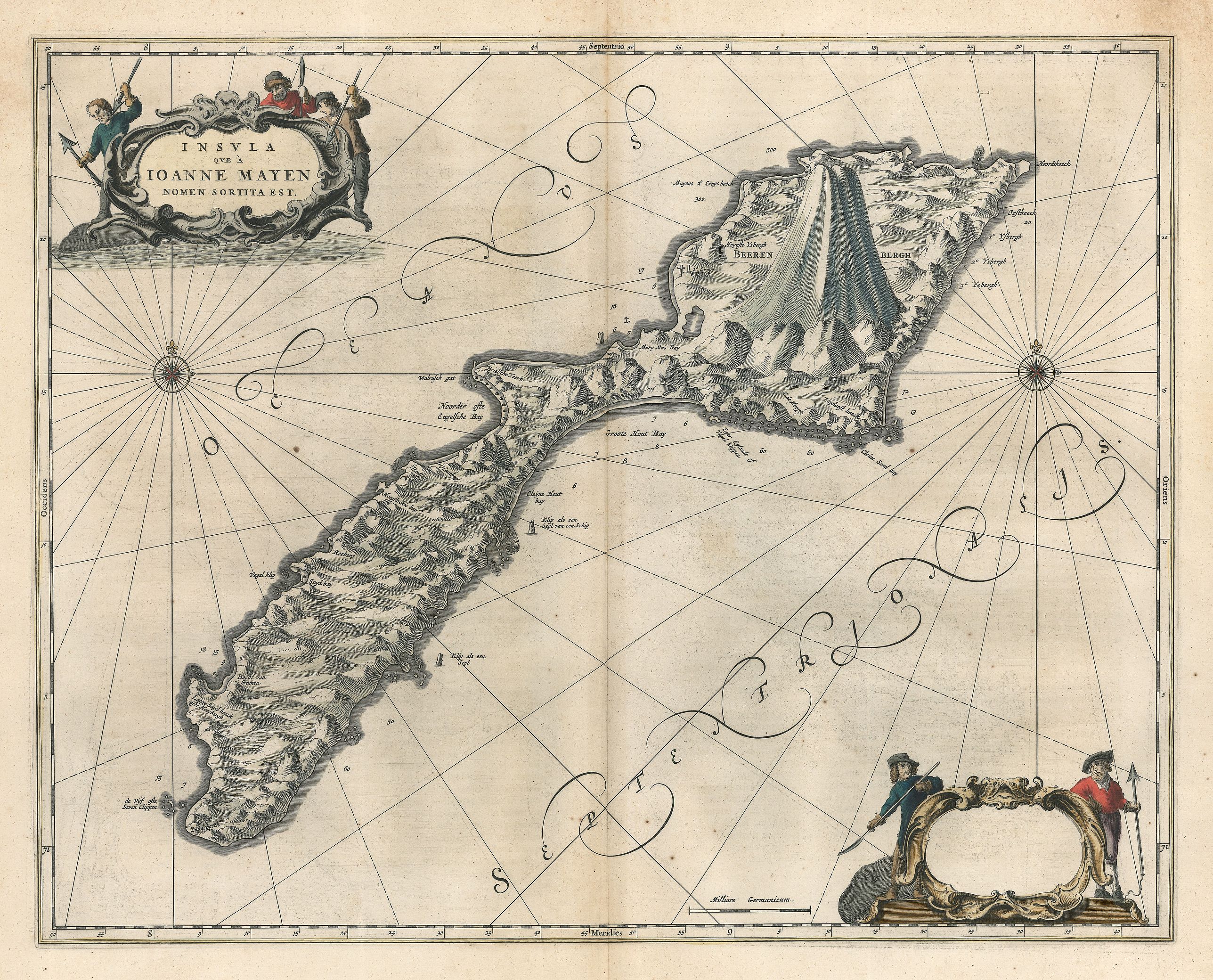
This remarkable map by Johannes Blaeu depicts the island of Jan Mayen, upon which is located the northernmost volcano on planet Earth, Beerenberg. It is a small island in the North Atlantic approximately 350 miles to the east of Greenland and Iceland, and 620 to the west of Norway, on the mid-Atlantic ridge. Terrain of the island and its volcano is shown in great detail, and landmarks of the environs are named, such as rock formations offshore which resemble the sails of a ship. The Dutch presence on the island, though short-lived, is detailed for perpetuity in this map. Boilers built for extracting oil from whale blubber are depicted and a small cemetery is visible to the west of Beerenberg. Safe anchorages are denoted, along with depth soundings in many places
Though legend has it that it was discovered by an Irish monk in the sixth century, and that the Vikings also visited, to date, no evidence has been found to support these claims. However, the monk reported that on one of his voyages he had come close to a black island which was on fire, and that great noise was generated by it. He concluded that he had found the entrance to hell. Thus, it is possible that Brendan, the Irish monk, did indeed sail close to the island.
Documented discovery of the island took place early in the 17th century when Dutch and English whalers sailed there in search of whaling grounds. The island was first surveyed in the first decades of the 17th century at which time there were found to be no indigenous peoples on the island. Its location was convenient for the whaling industry, and the Dutch soon constructed boilers for whale blubber, and when whaling was at its peak there were often more than 1,000 men based there during the summer months. Small though the population was, fortification was constructed to protect the industrial bases from being plundered. The industry was rapacious and within a few decades whaling in the area came to an end, as the whale population had been decimated. The island was completely deserted by mid-seventeenth century, and would only be visited again more than 200 years later.
Norway became interested in Jan Mayen in the early decades of the 20th century as a weather station, and by 1921 the first meteorological post on the island had been established. Weather reports from the island were important for predicting weather in Scandinavia and in 1922 the island was annexed by Norway. In 1930 it was declared part of the Kingdom of Norway.
The map is embellished with two decorative cartouches featuring whalers and their weaponry, with the heads of whales to signify their trade, and two compass roses. Latin text on the verso describes the island in some detail.
FAQ - Guarantee - Shipping
994 BuyBidBuying in the BuyNow Gallery
This item is available for immediate purchase when a "Add to Cart" or "Inquire Now" button is shown.
Payments are accepted in Euros or US Dollars. We accept most major credit cards, PayPal and bank transfer.
Authenticity Guarantee
 We provide professional descriptions, condition report and HiBCoR rating (based on 45 years experience in the map business)
We fully guarantee the authenticity of items we sell. We provide a certificate of authenticity for each purchased item.
Condition / Coloring
We indicate the condition of each item and use our unnique HiBCoR grading system in which four key items determine a map's value: Historical Importance, Beauty, Condition/Coloring and Rarity.
We offer many maps in their original black and white condition. We do not systematically color-up maps to make them more sellable to the general public or buyer.
Copper engraved or wood block maps are always hand colored. Maps were initially colored for aesthetic reasons and to improve readability. Nowadays, it is becoming a challenge to find maps in their original colors and are therefor more valuable.
We use the following color keys in our catalog:
Original colors; mean that the colors have been applied around the time the map was issued.
Colored; If the colors are applied recently or at the end of the 20th century, then "colored", or "attractive colors" will be used.
Original o/l colors; means the map has only the borders colored at the time of publication.
Read more about coloring of maps [+]
FAQ
Please have a look for more information about buying in the BuyNow gallery.
Many answers are likely to find in the general help section.
My Collection+
![]()
With My Collection+ you can collect all your favorite items in one place. It is free, and anyone can create his or her virtual map collection.
Unless you are logged in, the item is only saved for this session. You have to be registed and logged-in if you want to save this item permanently to My Collection+.
Read More [+]
If you want to save the items permanently, please sign in
or create account first. ![]()
Registering Here, it is and you do not need a credit card.
Add this item to
My Collection+
or click the following link to see My Collection+.
Invoice
The invoice and certificates of authenticity are available in the client center >Invoices
| Digital Image Download | |
|
Paulus Swaen maintains an archive of most of our high-resolution rare maps, prints, posters and medieval manuscript scans. We make them freely available for download and study. Read more about free image download |
Click the image for a free small image download. |
In accordance with the EU Consumer Rights Directive and habitually reside in the European Union you have the right to cancel the contract for the purchase of a lot, without giving any reason.
The cancellation period will expire 14 calendar days from the day after the date on which you or a third party (other than the carrier and indicated by you) acquires, physical possession of the lot. To exercise the right to cancel you must inform Paulus Swaen Inc, of your decision to cancel this contract by a clear statement (e.g. a letter sent by post, or e-mail (amsterdam@swaen.com).
To meet the cancellation deadline, it is sufficient for you to send your communication concerning your exercise of the right to cancel before the cancellation period has expired.
