Subscribe to be notified if similar examples become available.
Hungaria |
||||||||||||||||||||
|
||||||||||||||||||||
|
|
||||||||||||||||||||
|
Selling price: $ Please login to see price!
Sold in 2010 Missed this item! Add your name to our mailing list and be the first to get notified about our newly added listings. . |
My Collection +
Add this or any of your favorite items in one place. If you want to save the items permanently, you have to sign in or create an account first. |
|||||||||||||||||||
Description
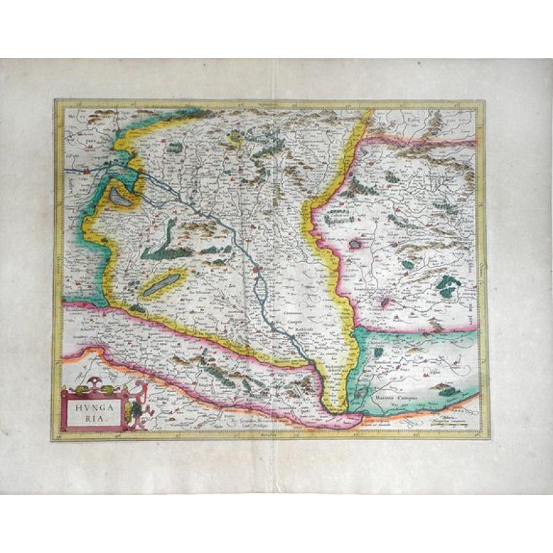
Fine Mercator/Hondius map of Hungary. Includes the Boloton (Balaton) Lake, Neusiedler Sea, the city of Budapest and the rivers, forests, mountains, villages of castles of Hungary and the surrounding regions. Accompanying Latin text on verso. Fantastic, vibrant original color.
For nearly sixty years, during the most important and exciting period in the story of modern mapmaking, Gerard Mercator was the supreme cartographer, his name, second only to Ptolemy, synonymous with forms of map projection still in use today. His influence transformed land surveying and his research and calculations lead him to break away from Ptolemy's conception of the size and outline of the continents, developing a projection that drastically reduced the longitudinal length of Europe and Asia and altered the shape of the Old World as visualized in the early 16th century. Although not the inventor of this type of projection, Mercator was the first to apply it to navigational charts in such a form that compass bearing could be plotted on charts in straight lines, thereby providing seamen with a solution to an age-old problem of navigation at sea. Mercator's innovations, including the aptly named Mercator projection, continue to be employed in maps produced today, 400 years later.
The geographer died in 1594 after publishing just a few parts of the atlas that he had spent decades preparing. In 1604, after the death of Gerard's son Rumold, the plates for his maps were sold to the great Amsterdam cartographer, Jodocus Hondius, who brought out the first of the so-called "Mercator-Hondius" editions in 1606. Hondius supplemented the original 107 maps with 39 new maps compiled under his own supervision, bringing the total number to 146, and had the original text expanded by Petrus Montanus. The new maps were of extremely high quality, and were for the most part devoted to parts of the world, such as America, that had been neglected by Mercator.
Hondius's first edition of the general atlas proved instantly popular, selling out within a year. Hondius continued to augment and perfect the atlas over the following years, constantly adding new maps and incorporating new discoveries and corrections.
FAQ - Guarantee - Shipping
Buying in the BuyNow Gallery
This item is available for immediate purchase when a "Add to Cart" or "Inquire Now" button is shown.
Items are sold in the EU margin scheme
Payments are accepted in Euros or US Dollars.
Authenticity Guarantee
 We provide professional descriptions, condition report (based on 45 years experience in the map business)
Paulus Swaen warrants the authenticity of our items and a certificate of authenticity is provided for each acquired lot.
Condition and Coloring
We indicate the condition of each item and use our unnique HiBCoR grading system in which four key items determine a map's value: Historical Importance, Beauty, Condition/Coloring and Rarity.
Color Key
We offer many maps in their original black and white condition. We do not systematically color-up maps to make them more sellable to the general public or buyer.
Copper engraved or wood block maps are always hand colored. Maps were initially colored for aesthetic reasons and to improve readability. Nowadays, it is becoming a challenge to find maps in their original colors and are therefor more valuable.
We use the following color keys in our catalog:
Original colors; mean that the colors have been applied around the time the map was issued.
Original o/l colors; means the map has only the borders colored at the time of publication.
Colored; If the colors are applied recently or at the end of the 20th century.
Read more about coloring of maps [+]
Shipping fee
A flat shipping fee of $ 30 is added to each shipment by DHL within Europe and North America. This covers : International Priority shipping, Packing and Insurance (up to the invoice amount).
Shipments to Asia are $ 40 and rest of the world $50
We charge only one shipping fee when you have been successful on multiple items or when you want to combine gallery and auction purchases.
Read more about invoicing and shipping
FAQ
Please have a look for more information about buying in the BuyNow gallery
Many answers are likely to find in the general help section.
My Collection+
![]()
With My Collection+ you can collect all your favorite items in one place. It is free, and anyone can create his or her virtual collection.
Unless you are logged in, the item is only saved for this session. You have to be registed and logged-in if you want to save this item permanently to My Collection+.
Read More[+]
Register here, it is free and you do not need a credit card.
Add this item to
My Collection+
or click the following link to see My Collection+.
| Digital Image Download | |
|
Paulus Swaen maintains an archive of most of our high-resolution rare maps, prints, posters and medieval manuscript scans. We make them freely available for download and study. Read more about free image download |
Click the image for a free small image download. |
In accordance with the EU Consumer Rights Directive and habitually reside in the European Union you have the right to cancel the contract for the purchase of a lot, without giving any reason.
The cancellation period will expire 14 calendar days from the day after the date on which you or a third party (other than the carrier and indicated by you) acquires, physical possession of the lot. To exercise the right to cancel you must inform Paulus Swaen Inc, of your decision to cancel this contract by a clear statement (e.g. a letter sent by post, or e-mail.
To meet the cancellation deadline, it is sufficient for you to send your communication concerning your exercise of the right to cancel before the cancellation period has expired.
