Subscribe to be notified if similar examples become available.
1613 MERCATOR, G. - HUNGARIA Per Gerardum Mercatorem
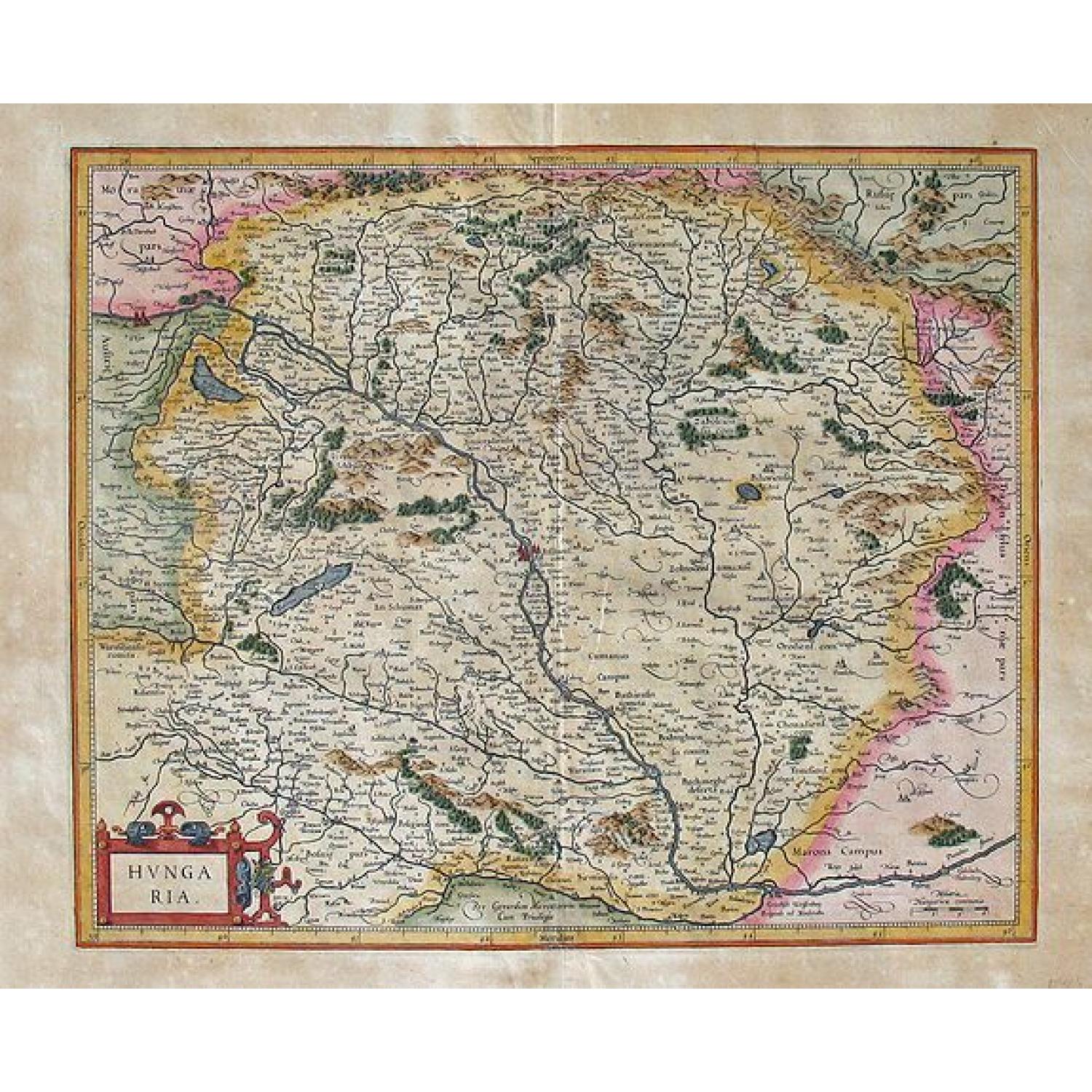
HUNGARIA Per Gerardum Mercatorem
| Maker: | MERCATOR, G. | |
| Date: | Duisburg and later Amsterdam, (1585-95) 1613 | |
| Colored: | Colored. | |
| Size: | 370 x 445 mm / 14.6 x 17.5 inches | |
| Condition: | Good Condition overall, with a repaired bottom marginal separation on the verso and a repaired centerfold separation. Some light toning to the wide margins. | |
 Add/Remove this item to MyCollection+




Description
Gerard Mercator (1512-1594) was one of the most famous geographers of his time. His name is familiar to this day. Mercator was noted for his rigorous and methodical approach to the preparation of his maps. He, and his family members, were responsible for the research and development of the maps, and much of their engraving, printing, and publication.
In 1585, this map was first published. In 1595, the map was included in the famous Mercator Atlas Sive Cosmographicae... After the edition of 1595, one further edition of this atlas was published by the Mercator family in Duisberg in 1602 with this same map. In 1604, the copperplates for the atlas were sold to Jodocus Hondius and Cornelis Claesz. In 1606, Hondius introduced a completely revised edition of Mercator's atlas, Atlas sive Cosmographicae...... and used this map from the Mercator plates for inclusion in the atlas, or as it is often called, the Mercator-Hondius atlas. Jodocus Hondius (1563-1612) was the founder of the famous 17th century Dutch map publishing family. Hondius, along with sons Jodocus II and Henricus and son-in-law Jan Janssonius, was prominent in Dutch cartography and his family competed aggressively with the emerging Blaeu family map business.
There is Latin text on the verso describing the "Hungaria Regnum" with a signature of "Dddddd" signifying that this map came from an edition of the atlas of 1613 (vd Krogt, p. 615). This map last appeared in a Dutch edition of the atlas in 1634. This map was changed and a new copperplate was engraved and included in the Mercator-Hondius series of atlases by Henricus Hondius with other maps of the region following.
Reference: Van der Krogt, Peter. Koeman's Atlantes Neerlandici, vol. 1. 't Goy-Houten: HES Publishers,1997.
Gerardus Mercator (1512-1594)
Born in the Flemish town of Rupelmonde, he died in 1594 in Duisburg/Germany. Still in the Spanish Netherlands, he prepared astronomical tools, Globes, the Chart of Palestine and Flanders, his World Map of 1538, and a treatise on the use of italics on charts. In 1544, he was suspected of heretical thoughts and spent some time in jail in Rupelmonde, but was released that same year.Eight years later, he settled in Duisburg, a town in the Duchy of Jülich-Cleves-Berg, perhaps to teach at the university, which the Duke had in mind. In 1538, Mercator published a 14 by 21 inch (36 by 55 cm) world map laid out on the double cordiform (double heart-shaped) projection, pioneered in 1531 by the French mathematician Oronce Finé. Mercator’s following publication was a detailed 34 by 46 inch (87 by 117 cm) map of Flanders, printed as four sheets in 1540. Prepared at the urging of Flemish merchants, the map was based on precise trigonometric and field surveys.
FAQ - Guarantee - Shipping
Buying in the BuyNow Gallery
This item is available for immediate purchase when an "Add to Cart" or "Inquire Now" button is shown.
Items are sold in the EU margin scheme.
Payments are accepted in Euros or US Dollars.
Authenticity Guarantee
 We provide professional descriptions and a condition report (based on 45 years experience in the map business).
Paulus Swaen warrants the authenticity of our items and a certificate of authenticity is provided for each acquired lot.
Condition and Coloring
We indicate the condition of each item and use our unique HiBCoR grading system in which four key items determine a map's value:
Historical Importance, Beauty, Condition/Coloring and Rarity.
We offer many maps in their original black and white condition. We do not systematically color-up maps to make them more sellable to the general public or buyer.
Copper engraved or wood block maps are always hand colored. Maps were initially colored for aesthetic reasons and to improve readability.
Nowadays it is becoming a challenge to find maps in their original colors, and these are therefore more valuable.
We use the following color keys in our catalog:
- Original colors: the colors were applied around the time the map was issued.
- Original o/l colors: only the borders were colored at the time of publication.
- Colored: the colors were applied recently or at the end of the 20th century ("attractive colors" may also be used).
Read more about coloring of maps [+]
Shipping fee
A flat shipping fee of $30 is added to each shipment by DHL within Europe and North America. This covers international priority shipping, packing and insurance (up to the invoice amount).
Shipments to Asia are $40 and rest of the world $50.
We charge only one shipping fee when you have been successful on multiple items or when you want to combine gallery and auction purchases.
Read more about invoicing and shipping
FAQ
Please have a look for more information about buying in the BuyNow gallery.
Many answers are likely to be found in the general help section.
MyCollection+

With MyCollection+ you can collect all your favorite items in one place. It is free, and anyone can create his or her virtual collection.
Unless you are logged in, the item is only saved for this session. You have to be registered and logged in if you want to save this item permanently.
Read more [+]
Register here, it is free and you do not need a credit card.
Add this item to
MyCollection+
or see MyCollection+.
Paulus Swaen maintains an archive of most of our high-resolution rare maps, prints, posters and medieval manuscript scans.
We make them freely available for download and study.
Read more about free image download
Click the image for a free small image download.

YOUR RIGHT TO CANCEL THE PURCHASE OF A LOT
In accordance with the EU Consumer Rights Directive and habitually reside in the European Union you have the right to cancel the contract for the purchase of a lot, without giving any reason.
The cancellation period will expire 14 calendar days from the day after the date on which you or a third party (other than the carrier and indicated by you) acquires, physical possession of the lot. To exercise the right to cancel you must inform Paulus Swaen Inc, of your decision to cancel this contract by a clear statement (e.g. a letter sent by post, or e-mail.
To meet the cancellation deadline, it is sufficient for you to send your communication concerning your exercise of the right to cancel before the cancellation period has expired.