Please login to see price!.
Subscribe to be notified if similar examples become available.
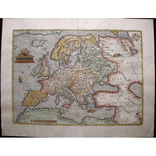
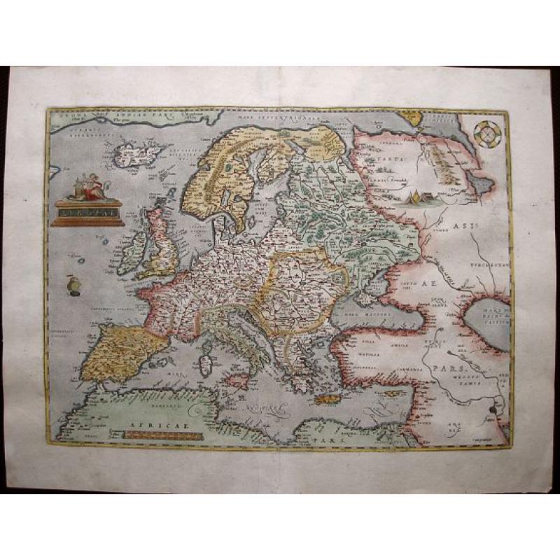
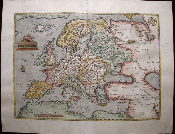
Europae. |
||||||||||||||||||||
|
||||||||||||||||||||
|
|
||||||||||||||||||||
|
Selling price: $...
Please login to see price! Sold in 2015 Missed this item! Be the first to get notified about our newly added listings. Add your name to our mailing list. Feel free to contact us if you have a question about this item. |
Collection - Save and collect this or any of your favorite items in one place.
If you want to save the items permanently, please sign in or create account first. |
|||||||||||||||||||
Description
Beautifully colored map of the Europe from the 1579 edition of Ortelius’Theatrum Orbis Terrarum, the first modern atlas of the world. Ortelius’ map of Europe became the model map for Europe maps for the next centuries, including here for the first time also the Scandinavian countries.
This first edition map is based upon several important maps of Europe, including Gerard Mercator's 1554 map of Europe. The map encompasses several highly decorative elements: a finely engraved cartouche shows a partially covered and apparently distraught Europa sitting on the back of Zeus in the form of a placid bull (he, the unwelcome lover of Europa), both gazing toward Europe, curious about its future.
Yurts and tents in remote Tartaria and an unusual design of compass rose at upper right. And also Iceland divided by a central river, monastery of St. Thomas in Greenland famous for its boiling springs, mythical islands of Brasil and Demar west of the British Isles.
The map extends to a severely distorted Caspian Sea - note the pictorial depiction of Mesopotamian Marshes in what is now Iraq. A tiny ship sails the Atlantic - despite measuring just 2 cm from the top of the mainmast to the waterline the master engraver incorporated a wealth of detail even into this minute decorative element. Attractive pictorial topography from the West to the East and the North to the South.
The 1579 edition was the first edition to be printed by the famous printing and publishing house of Christopher Plantin, the Officina Plantiniana, well-known for its high quality printing and publishing. In this auction, also the other continents from the 1579 edition, Africa, Asia, and America are offered, as well as the portrait of Ortelius issued for the first time in the atlas of 1579.
Reference: Broecke, Ortelius Atlas maps, 4.
FAQ - Guarantee - Shipping
Buying in the BuyNow Gallery
This item is available for immediate purchase when a "Add to Cart" or "Inquire Now" button is shown.
Items are sold in the EU margin scheme
Payments are accepted in Euros or US Dollars.
Authenticity Guarantee
 We provide professional descriptions, condition report (based on 45 years experience in the map business)
Paulus Swaen warrants the authenticity of our items and a certificate of authenticity is provided for each acquired lot.
Condition and Coloring
We indicate the condition of each item and use our unnique HiBCoR grading system in which four key items determine a map's value: Historical Importance, Beauty, Condition/Coloring and Rarity.
Color Key
We offer many maps in their original black and white condition. We do not systematically color-up maps to make them more sellable to the general public or buyer.
Copper engraved or wood block maps are always hand colored. Maps were initially colored for aesthetic reasons and to improve readability. Nowadays, it is becoming a challenge to find maps in their original colors and are therefor more valuable.
We use the following color keys in our catalog:
Original colors; mean that the colors have been applied around the time the map was issued.
Original o/l colors; means the map has only the borders colored at the time of publication.
Colored; If the colors are applied recently or at the end of the 20th century.
Read more about coloring of maps [+]
Shipping fee
A flat shipping fee of $ 30 is added to each shipment by DHL within Europe and North America. This covers : International Priority shipping, Packing and Insurance (up to the invoice amount).
Shipments to Asia are $ 40 and rest of the world $50
We charge only one shipping fee when you have been successful on multiple items or when you want to combine gallery and auction purchases.
Read more about invoicing and shipping
FAQ
Please have a look for more information about buying in the BuyNow gallery
Many answers are likely to find in the general help section.
Collection
![]()
With Collection you can collect all your favorite items in one place. It is free, and anyone can create his or her Virtual map collection.
Unless you are logged in, the item is only saved for this session. You have to be registed and logged-in if you want to save this item permanently to your Virtual Collection.
Read More[+]
Register here, it is free and you do not need a credit card.
Add this item to
Virtual Collection
or click the following link to see my Collection.
| Digital Image Download | |
|
Paulus Swaen maintains an archive of most of our high-resolution rare maps, prints, posters and medieval manuscript scans. We make them freely available for download and study. Read more about free image download |
Click the image for a free small image download. |
In accordance with the EU Consumer Rights Directive and habitually reside in the European Union you have the right to cancel the contract for the purchase of a lot, without giving any reason.
The cancellation period will expire 14 calendar days from the day after the date on which you or a third party (other than the carrier and indicated by you) acquires, physical possession of the lot. To exercise the right to cancel you must inform Paulus Swaen Inc, of your decision to cancel this contract by a clear statement (e.g. a letter sent by post, or e-mail (amsterdam@swaen.com).
To meet the cancellation deadline, it is sufficient for you to send your communication concerning your exercise of the right to cancel before the cancellation period has expired.

