Subscribe to be notified if similar examples become available.
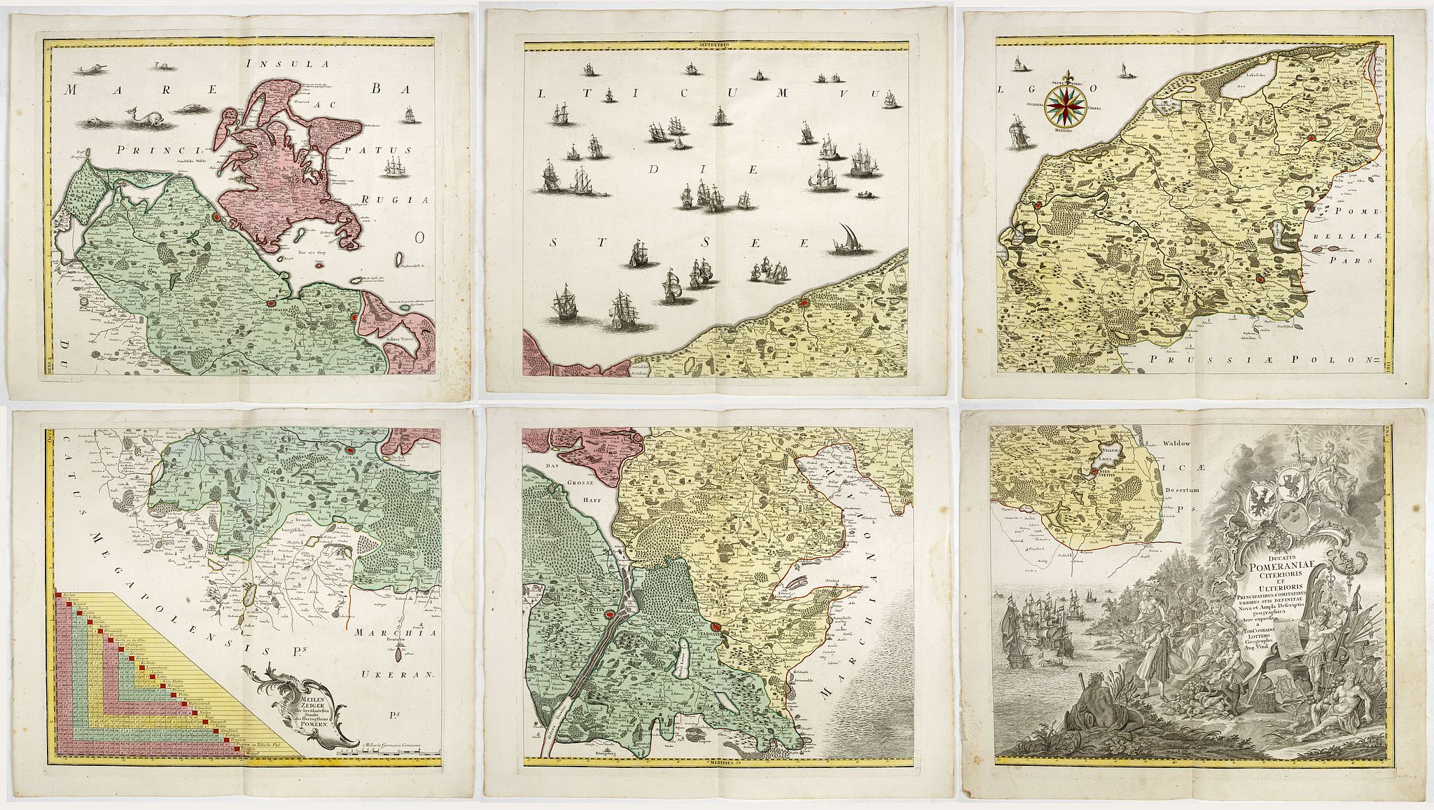
Ducatus Pomeraniae Citerioris et Ulterioris. Principatibus, Comitatibus urbibus suis definitae Nova et Ampla Descriptio geographica . |
||||||||||||||||||||
|
||||||||||||||||||||
|
|
||||||||||||||||||||
|
|
My Collection +
Add this or any of your favorite items in one place. If you want to save the items permanently, you have to sign in or create an account first. |
|||||||||||||||||||
Description
Fine example of T.C. Lotter's 6-sheet map of Pomerania, first published in about 1760 by Seutter. Showing the region on the south coast of the Baltic shared between Germany and Poland, from the Recknitz River near Stralsund in the west, via the Oder River delta near Szczecin, to the mouth of the Vistula River near Gdansk in the east.
Created by Professor Lubben of Rostock University on the orders of Philipp II, Duke of Pomerania, who wanted a large-scale map that would be a comprehensive geography and history of the duchy. Although Lubben had mapped the island of Rugen on the Pomeranian coast in 1609, he had very little geographic information to guide him: the only map to precede this one of Pomerania was a small map by Peter Artopaus (later used by Münster and Ortelius).
Lubben spent two years Lubben travelling throughout the country taking thousands of measurements, it was then another 6 years before the copperplates were completed, by Geelkerken in Amsterdam.
However, although a very small number of the sheets printed in 1618 are known to have been presented to the Pomeranian court the shortage of paper, and the 30 years war intervened, and no known copies of this printing have survived. It was not until 1757, after Geelkerken's original copperplates were discovered in the in Stralsund (a town featured in a vignette on the map), that the map was reissued.
Lubben's map was the model for virtually all atlas maps of Pomerania of the seventeenth century, including those of Blaeu and Janssonius, and Hondius dedicated his famous wall map of Asia to Lubben: see Shilder, "Monumenta Cartographica Neerlandica" VI, pp.150-151. It remained the only map of consequence of the region from its inception in 1618 until the Prussian topographical survey of the eighteenth century.
The map was reproduced by Seutter's map is a simplified version of the map, issued in approximately the same scale, but with numerous revisions and improvements. This is the re-issue by Tobias Conrad Lotter, with the title re-engraved.
Reference: Ausstellungskatalog Stettin 1998:
FAQ - Guarantee - Shipping
Buying in the BuyNow Gallery
This item is available for immediate purchase when a "Add to Cart" or "Inquire Now" button is shown.
Items are sold in the EU margin scheme
Payments are accepted in Euros or US Dollars.
Authenticity Guarantee
 We provide professional descriptions, condition report (based on 45 years experience in the map business)
Paulus Swaen warrants the authenticity of our items and a certificate of authenticity is provided for each acquired lot.
Condition and Coloring
We indicate the condition of each item and use our unnique HiBCoR grading system in which four key items determine a map's value: Historical Importance, Beauty, Condition/Coloring and Rarity.
Color Key
We offer many maps in their original black and white condition. We do not systematically color-up maps to make them more sellable to the general public or buyer.
Copper engraved or wood block maps are always hand colored. Maps were initially colored for aesthetic reasons and to improve readability. Nowadays, it is becoming a challenge to find maps in their original colors and are therefor more valuable.
We use the following color keys in our catalog:
Original colors; mean that the colors have been applied around the time the map was issued.
Original o/l colors; means the map has only the borders colored at the time of publication.
Colored; If the colors are applied recently or at the end of the 20th century.
Read more about coloring of maps [+]
Shipping fee
A flat shipping fee of $ 30 is added to each shipment by DHL within Europe and North America. This covers : International Priority shipping, Packing and Insurance (up to the invoice amount).
Shipments to Asia are $ 40 and rest of the world $50
We charge only one shipping fee when you have been successful on multiple items or when you want to combine gallery and auction purchases.
Read more about invoicing and shipping
FAQ
Please have a look for more information about buying in the BuyNow gallery
Many answers are likely to find in the general help section.
My Collection+
![]()
With My Collection+ you can collect all your favorite items in one place. It is free, and anyone can create his or her virtual collection.
Unless you are logged in, the item is only saved for this session. You have to be registed and logged-in if you want to save this item permanently to My Collection+.
Read More[+]
Register here, it is free and you do not need a credit card.
Add this item to
My Collection+
or click the following link to see My Collection+.
| Digital Image Download | |
|
Paulus Swaen maintains an archive of most of our high-resolution rare maps, prints, posters and medieval manuscript scans. We make them freely available for download and study. Read more about free image download |
Click the image for a free small image download. |
In accordance with the EU Consumer Rights Directive and habitually reside in the European Union you have the right to cancel the contract for the purchase of a lot, without giving any reason.
The cancellation period will expire 14 calendar days from the day after the date on which you or a third party (other than the carrier and indicated by you) acquires, physical possession of the lot. To exercise the right to cancel you must inform Paulus Swaen Inc, of your decision to cancel this contract by a clear statement (e.g. a letter sent by post, or e-mail.
To meet the cancellation deadline, it is sufficient for you to send your communication concerning your exercise of the right to cancel before the cancellation period has expired.
