Subscribe to be notified if similar examples become available.
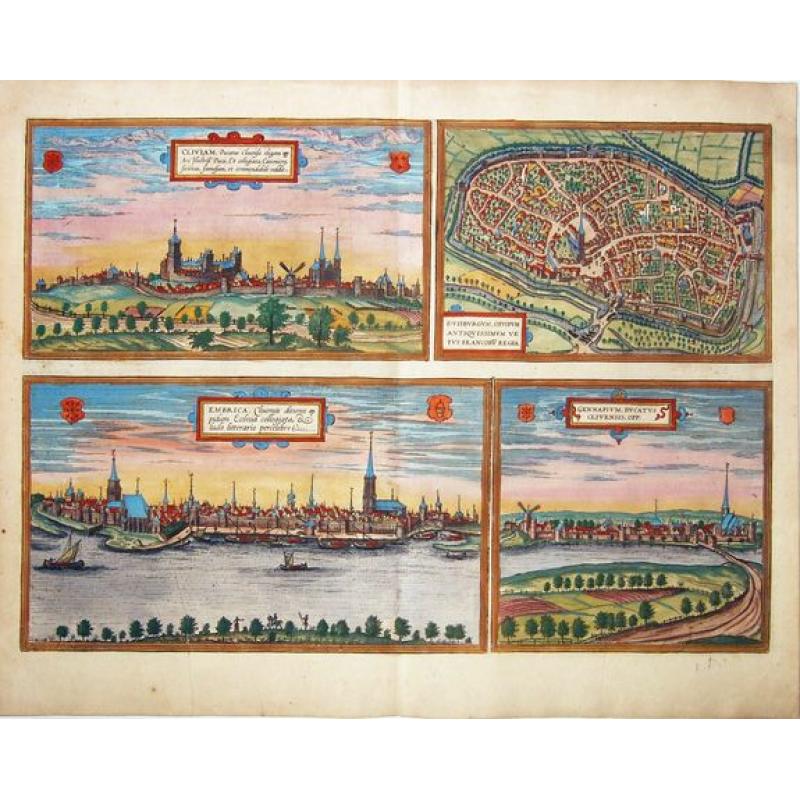
Cliviam, Ducatus Clivensis elegans opp: - Duisburgum, Oppidum Antiquissimum Vetus Francoru Regia - Embrica, Clivensis ditionis oppidum Ecclesia collegiata... - Gennapium, Ducatus Clivensis, Opp:.[Kleve, Duisbu. |
||||||||||||||||||||
|
||||||||||||||||||||
|
|
||||||||||||||||||||
|
Selling price: $ Please login to see price!
Sold in 2021 Missed this item! Add your name to our mailing list and be the first to get notified about our newly added listings. . |
My Collection + - Save and collect this or any of your favorite items in one place.
If you want to save the items permanently, please sign in or create account first. |
|||||||||||||||||||
Description
A fine copper engraving with four important early views of - Kleve, Duisburg, Emmerich, and Gennep - on a single sheet. From: 'Civitates Orbis Terrarum, ... Part 2'. Köln, 1575.
KLEVE. TRANSLATION OF CARTOUCHE TEXT: Kleve, an elegant town in the Duchy of Cleves, renowned and remarkable for the famous ducal castle and the collegiate foundation.
COMMENTARY BY BRAUN: "The city of Kleve in the Duchy of Cleves is highly regarded because of its age and because the Duke of Jülich, Cleves and Berg has a splendid castle here, where he holds his princely court, and also because of its collegiate church."
This view of Kleve, seen from the direction of the Mühlberg, is dominated by the castle of the Counts and Dukes of Cleves, which has been called Schwanenburg since the 19th century after the legendary Knight of the Swan, Helias.
The other building that dominates the silhouette of the city is the Gothic collegiate church of St Mary's Assumption. In the course of the changes carried out in the 15th century, the New City, known as the Hag Quarter, was founded. When the Cleves line died out in 1614, the city passed to Brandenburg. As a residence of the Electors of Brandenburg, Kleve took on the Baroque appearance that is still largely preserved today.
DUISBURG. CARTOUCHE: Duisburg, ancient town, the old royal palace of the Franks. COMMENTARY BY BRAUN: "Duisburg is a city in old Germany between the Ruhr and the Anger, in the old days the Rhine also flowed up to the city walls. As long as the city still bordered the Rhine, a fair was held here, which is now held in Frankfurt."
Duisburg is shown in a bird's-eye view from the west. In the middle of the city rises the late Gothic St Saviour's church, which dates back to the 9th century. This plate, which was faithfully reproduced by Merian even in 1647, also shows the harbor on the navigable dead arm of the Rhine, which gave the city great economic importance up to the 14th century.
But in 1290, when Duisburg was pledged by King Rudolf I to Dietrich of Cleves, it lost its privileges and its imperial importance and sank into insignificance as a little farming town. The industrial revolution in the 19th century and the development of the inland port led to an economic upturn.
EMMERICH. CARTOUCHE: Emmerich, a town under the rule of Cleves, famous because of its collegiate church and school. COMMENTARY BY BRAUN: "Emmerich is a little town in the Duchy of Cleves with elegant buildings and a great religious foundation, built by St Willibrord himself. Here is a good elementary school, in which many learned men have received their basic education, for many industrious rectors have headed this school."
This view from the opposite bank of the Rhine shows the city of Emmerich, which is mentioned in a document for the first time in 828. The city grew up around a church erected by St Willibrord c. 700 on the site where the church of St Aldegund with late medieval sculptures. In 1233 Emmerich was granted a municipal charter and in 1407 it became a member of the Hanseatic League.
GENAPPE. CARTOUCHE: Genappe, a town in the Duchy of Cleves. This town is located on the Dyle south of Brussels and is shown in the place set in a picturesque landscape, an impression that is reinforced by the windmill. Towards the end of the 12th century, the Dukes of Brabant erected a fortress here on the banks of the Dyle, which grew into a little town in the 13th and 14th centuries.
In the 15th century the future King Louis XI lived in the castle of Genappe. The town lost its importance as a result of the plague in 1533 and due to religious conflicts in 1578.
The 'Civitates Orbis Terrarum', or the "Braun & Hogenberg", is a six-volume town atlas and the greatest book of town views and plans ever published: 363 engravings, sometimes beautifully colored. It was one of the best-selling works in the last quarter of the 16th century. Georg Braun wrote the text accompanying the plans and views on the verso. A large number of the plates were engraved after the original drawings of Joris Hoefnagel (1542-1600), who was a professional artist. The first volume was published in Latin in 1572, the sixth volume in 1617. Frans Hogenberg created the tables for volumes I through IV, and Simon van den Neuwel created those for volumes V and VI.
Other contributors were cartographer Daniel Freese, and Heinrich Rantzau. Works by Jacob van Deventer, Sebastian Münster, and Johannes Stumpf were also used. Translations appeared in German and French.
More about Braun and Hogenberg, Civitatus [+]
Reference: Van der Krogt 4, 2061; Taschen, Braun and Hogenberg, p.171.
FAQ - Guarantee - Shipping
Buying in the BuyNow Gallery
This item is available for immediate purchase when a "Add to Cart" or "Inquire Now" button is shown.
Items are sold in the EU margin scheme
Payments are accepted in Euros or US Dollars.
Authenticity Guarantee
 We provide professional descriptions, condition report (based on 45 years experience in the map business)
Paulus Swaen warrants the authenticity of our items and a certificate of authenticity is provided for each acquired lot.
Condition and Coloring
We indicate the condition of each item and use our unnique HiBCoR grading system in which four key items determine a map's value: Historical Importance, Beauty, Condition/Coloring and Rarity.
Color Key
We offer many maps in their original black and white condition. We do not systematically color-up maps to make them more sellable to the general public or buyer.
Copper engraved or wood block maps are always hand colored. Maps were initially colored for aesthetic reasons and to improve readability. Nowadays, it is becoming a challenge to find maps in their original colors and are therefor more valuable.
We use the following color keys in our catalog:
Original colors; mean that the colors have been applied around the time the map was issued.
Original o/l colors; means the map has only the borders colored at the time of publication.
Colored; If the colors are applied recently or at the end of the 20th century.
Read more about coloring of maps [+]
Shipping fee
A flat shipping fee of $ 30 is added to each shipment by DHL within Europe and North America. This covers : International Priority shipping, Packing and Insurance (up to the invoice amount).
Shipments to Asia are $ 40 and rest of the world $50
We charge only one shipping fee when you have been successful on multiple items or when you want to combine gallery and auction purchases.
Read more about invoicing and shipping
FAQ
Please have a look for more information about buying in the BuyNow gallery
Many answers are likely to find in the general help section.
My Collection+
![]()
With My Collection+ you can collect all your favorite items in one place. It is free, and anyone can create his or her virtual collection.
Unless you are logged in, the item is only saved for this session. You have to be registed and logged-in if you want to save this item permanently to My Collection+.
Read More[+]
Register here, it is free and you do not need a credit card.
Add this item to
My Collection+
or click the following link to see My Collection+.
| Digital Image Download | |
|
Paulus Swaen maintains an archive of most of our high-resolution rare maps, prints, posters and medieval manuscript scans. We make them freely available for download and study. Read more about free image download |
Click the image for a free small image download. |
In accordance with the EU Consumer Rights Directive and habitually reside in the European Union you have the right to cancel the contract for the purchase of a lot, without giving any reason.
The cancellation period will expire 14 calendar days from the day after the date on which you or a third party (other than the carrier and indicated by you) acquires, physical possession of the lot. To exercise the right to cancel you must inform Paulus Swaen Inc, of your decision to cancel this contract by a clear statement (e.g. a letter sent by post, or e-mail (amsterdam@swaen.com).
To meet the cancellation deadline, it is sufficient for you to send your communication concerning your exercise of the right to cancel before the cancellation period has expired.
