Subscribe to be notified if similar examples become available.
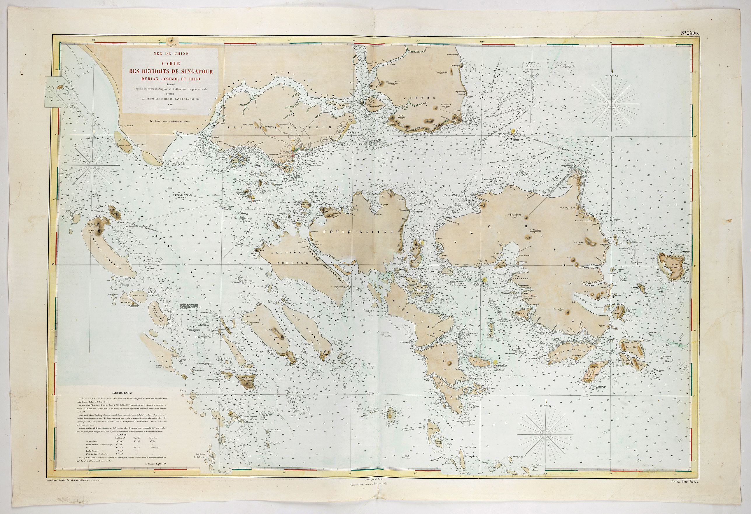
Carte Des Detroits De Singapour Durian, Jombol et Rhio Dressee d'apres les travaux Anglais et Hollandais les plus recents . . . 1866 |
||||||||||||||||||||
|
||||||||||||||||||||
|
|
||||||||||||||||||||
|
|
My Collection +
Add this or any of your favorite items in one place. If you want to save the items permanently, you have to sign in or create an account first. |
|||||||||||||||||||
Description
Rare separately issued chart of Singapore, extending to Johore, Battam, Bintang, Rempang, Galang, Jombol, Suji, Sanbon and neighboring islands, depicting coastal features, soundings, light houses, sailing directions and a host of other information.
The first edition of the map was published in 1866, utilizing French and English sources. Among other features, the maps prominently note the two lighthouses erected under the direction of John Turnbull Thomson.
The chart is one of the earliest maps to focus in significant detail on the region, following only 20 years after John Turnbull Thomson and Samuel Congalton's original survey work in the region led to the publication of his monumental 2 sheet chart of the region in 1846, which was later revised and re-issued in 1855.
This edition is updated to 1870 ( a later edition of 1887 is more commonly seen). The chart is drawn from a British Admiralty Chart entitled SINGAPORE STRAIT By Staff Commander JW Reed Navg Lieuts TH Tizard... Assisted by the Officers of HMS Rifleman 1865-1869.
Thomson arrived in the Malay Straits in 1838 and was employed by the East India Survey. In 1841, he was appointed Government Surveyor at Singapore and in 1844, became Superintendent of Roads and Public Works. Thomson was responsible for designing and constructing a number of notable engineering works including bridges, roads, and hospitals. He conducted the allotment survey of Singapore, the topographical survey of the island of Singapore and its dependencies, and the marine survey of the Straits of Singapore and the east coasts of Johore and Penang. His outstanding achievement was the erection of the Horsburgh Lighthouse on Pedra Branca.
The chart appeared one year prior to the establishment of the Straits Settlements as a separate British Colony on April 1, 1867. With the advent of the steamship in the mid-1860s and the opening of the Suez Canal in 1869, Singapore became a major port of call for ships plying between Europe and East Asia. With the development of rubber planting, especially after the 1870s, it also became the main sorting and export center in the world for rubber. By the end of the 19th Century, Singapore was experiencing unprecedented prosperity as its international trade expanded dramatically.
FAQ - Guarantee - Shipping
Buying in the BuyNow Gallery
This item is available for immediate purchase when a "Add to Cart" or "Inquire Now" button is shown.
Items are sold in the EU margin scheme
Payments are accepted in Euros or US Dollars.
Authenticity Guarantee
 We provide professional descriptions, condition report (based on 45 years experience in the map business)
Paulus Swaen warrants the authenticity of our items and a certificate of authenticity is provided for each acquired lot.
Condition and Coloring
We indicate the condition of each item and use our unnique HiBCoR grading system in which four key items determine a map's value: Historical Importance, Beauty, Condition/Coloring and Rarity.
Color Key
We offer many maps in their original black and white condition. We do not systematically color-up maps to make them more sellable to the general public or buyer.
Copper engraved or wood block maps are always hand colored. Maps were initially colored for aesthetic reasons and to improve readability. Nowadays, it is becoming a challenge to find maps in their original colors and are therefor more valuable.
We use the following color keys in our catalog:
Original colors; mean that the colors have been applied around the time the map was issued.
Original o/l colors; means the map has only the borders colored at the time of publication.
Colored; If the colors are applied recently or at the end of the 20th century.
Read more about coloring of maps [+]
Shipping fee
A flat shipping fee of $ 30 is added to each shipment by DHL within Europe and North America. This covers : International Priority shipping, Packing and Insurance (up to the invoice amount).
Shipments to Asia are $ 40 and rest of the world $50
We charge only one shipping fee when you have been successful on multiple items or when you want to combine gallery and auction purchases.
Read more about invoicing and shipping
FAQ
Please have a look for more information about buying in the BuyNow gallery
Many answers are likely to find in the general help section.
My Collection+
![]()
With My Collection+ you can collect all your favorite items in one place. It is free, and anyone can create his or her virtual collection.
Unless you are logged in, the item is only saved for this session. You have to be registed and logged-in if you want to save this item permanently to My Collection+.
Read More[+]
Register here, it is free and you do not need a credit card.
Add this item to
My Collection+
or click the following link to see My Collection+.
| Digital Image Download | |
|
Paulus Swaen maintains an archive of most of our high-resolution rare maps, prints, posters and medieval manuscript scans. We make them freely available for download and study. Read more about free image download |
Click the image for a free small image download. |
In accordance with the EU Consumer Rights Directive and habitually reside in the European Union you have the right to cancel the contract for the purchase of a lot, without giving any reason.
The cancellation period will expire 14 calendar days from the day after the date on which you or a third party (other than the carrier and indicated by you) acquires, physical possession of the lot. To exercise the right to cancel you must inform Paulus Swaen Inc, of your decision to cancel this contract by a clear statement (e.g. a letter sent by post, or e-mail.
To meet the cancellation deadline, it is sufficient for you to send your communication concerning your exercise of the right to cancel before the cancellation period has expired.
