Subscribe to be notified if similar examples become available.
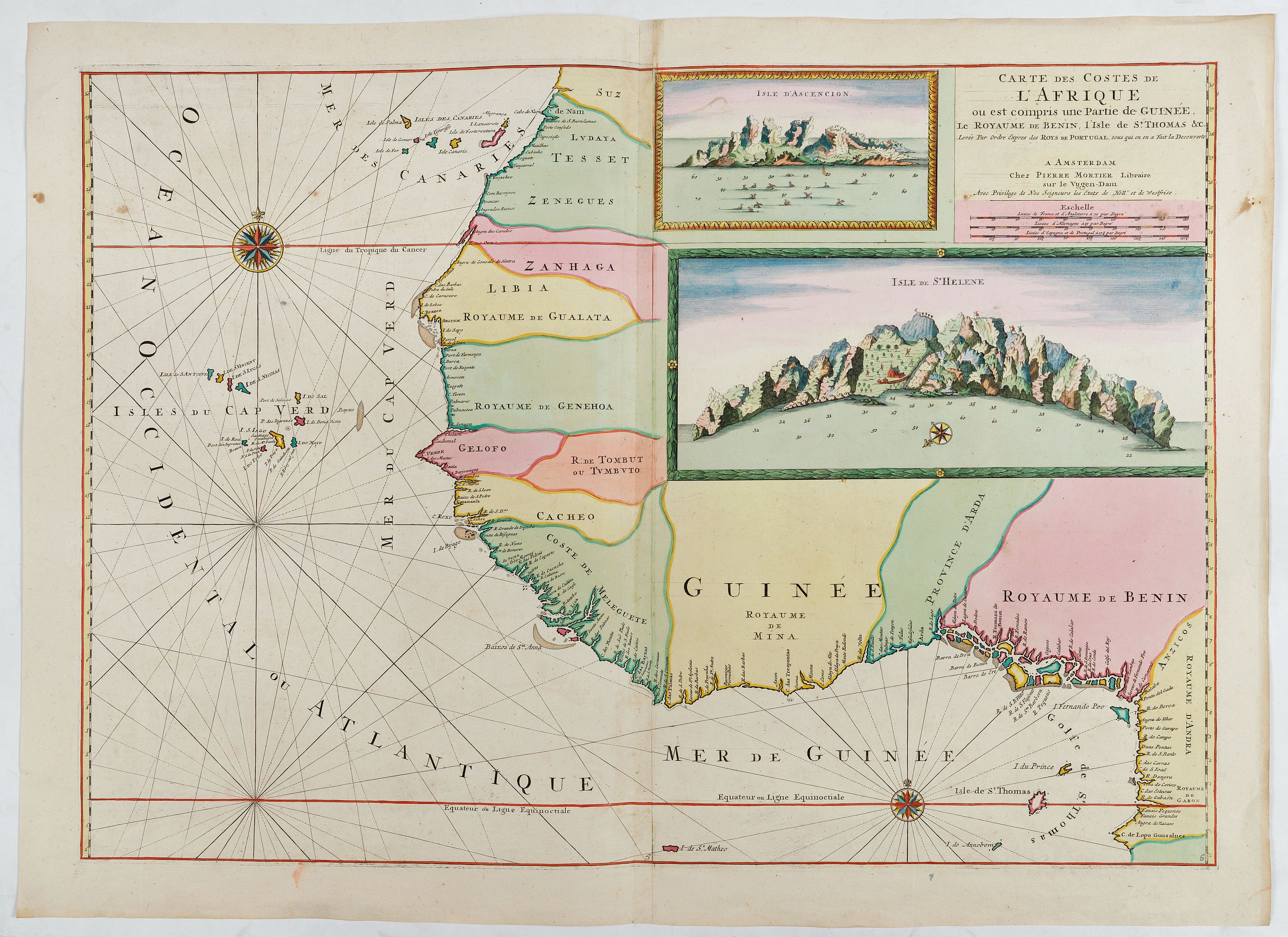
1705 MORTIER, P. - Carte Des Costes De L Afrique ou est compris une Partie de Guinée, le Royaume De Benin, l Isle de St. Thomas &c. Levée Par Ordre Expres des Roys De Portugal sous qui on en a Fait la Decouverte.
Carte Des Costes De L Afrique ou est compris une Partie de Guinée, le Royaume De Benin, l Isle de St. Thomas &c. Levée Par Ordre Expres des Roys De Portugal sous qui on en a Fait la Decouverte.
| Maker: | MORTIER, P. | |
| Date: | Amsterdam, 1705 | |
| Colored: | In attractive original colors. | |
| Size: | 535 x 760 mm / 21.1 x 29.9 inches | |
| Condition: | Mint condition and stunning original coloring. Heightened with gold. On two joined sheets. | |
-This item is available for immediate sale





Description
Stunning map of the west coast of Africa with insets: Isle d' Ascencion & Isle de St. Helene. From "Neptunus, de Fransche, of nieuwe atlas van de zeekarten, opgenommen en gegraveerd door uitdrukkelyke order des Konings, tot het gebruik van zyne zeemachten ... ".
The island was sighted on 21 May 1502 by the four ships of the 3rd Portuguese Armada commanded by Galician navigator João da Nova during the return voyage to Lisbon, and he named it Santa Helena after Saint Helena of Constantinople.
The Dutch Republic formally claimed Saint Helena in 1633, although there is no evidence that they ever occupied it. The Dutch lost interest in the island after establishing their Cape of Good Hope colony.
In 1657, Oliver Cromwell granted the East India Company (EIC) a charter to govern Saint Helena and, the following year, the company decided to fortify the island and settle it with planters.
In 1815, the British government selected Saint Helena as the place of exile for Napoleon Bonaparte after he lost the Battle of Waterloo. He was taken to the island in October 1815. Napoleon stayed at the Briars pavilion, on the grounds of the Balcombe family's home until his permanent residence at Longwood House was completed in December 1815. He died there on 5 May 1821.
Parts of the item are heightened in gold.
Read more about maps heightened in gold.
Pierre Mortier (1661-1711)
Pierre (Pieter) Mortier (Leiden, 1661 – Amsterdam, 1711) Dutch publisher, engraver and print seller of French Huguenot descent; best known for his Amsterdam editions of French maps and for Le Neptune François (1693) Mortier is the founder of the family business that later became Covens & Mortier (see the earlier entry). Life Pierre Mortier his grandparents were French refugees who left France around 1625 for Leiden, and his parents settled in Amsterdam in 1661 or 1662. He grew up in Amsterdam, then lived in Paris from 1681 to about 1685, where he entered the book trade and adopted the French form of his name, Pierre, which he kept throughout his career.Back in Amsterdam, he specialized in French books and kept up his relationships with Parisian publishers. At that time Amsterdam was the international marketplace for books, especially those forbidden by repressive governments.
Much of his business consisted of issuing embellished, high-quality Amsterdam editions of contemporary French maps, generally with the permission of their authors. This was a significant advantage, because most Dutch publishers had by then fallen into reprinting their own outdated work, while French cartographers were producing the most accurate and up-to-date charts anywhere. In 1690 he was granted a privilege (an early form of copyright) to publish French maps in the Dutch lands.
Mortier’s cartographic work culminated in the nautical atlas Le Neptune François, ou Atlas nouveau des cartes marines. The original French Neptune François, by Charles Pène and others, was produced in 1693 for the French navy. Mortier re-engraved the plates in a richly coloured version and added to the titles the words “Levée et Gravée par Ordre du Roy à Paris 1693,” though they were in fact engraved, coloured and published in Amsterdam. He released the first volume in 1693 and followed with an expanded, unofficial Amsterdam supplement, the Suite du Neptune François (c. 1700). The supplement included charts that the French navy’s edition lacked, such as the large chart of the Chesapeake Bay and Delaware River. A 1703 world chart showing California as an island appeared in the Mortier edition.
Beside the Neptune he published the "Nouveau Théâtre d’Italie" (1704) reissued Joan Blaeu’s Italian city atlas of 1663.
FAQ - Guarantee - Shipping
This item is available for immediate purchase when a "Add to Cart" or "Inquire Now" button is shown.
Items are sold in the EU margin scheme
Payments are accepted in Euros or US Dollars.
Authenticity Guarantee
 We provide professional descriptions, condition report (based on 45 years experience in the map business)
Paulus Swaen warrants the authenticity of our items and a certificate of authenticity is provided for each acquired lot.
Condition and Coloring
We indicate the condition of each item and use our unique HiBCoR grading system in which four key items determine a map's value: Historical Importance, Beauty, Condition/Coloring and Rarity.
Color Key
We offer many maps in their original black and white condition. We do not systematically color-up maps to make them more sellable to the general public or buyer.
Copper engraved or wood block maps are always hand colored. Maps were initially colored for aesthetic reasons and to improve readability. Nowadays, it is becoming a challenge to find maps in their original colors and are therefor more valuable.
We use the following color keys in our catalog:
Original colors; mean that the colors have been applied around the time the map was issued.
Original o/l colors; means the map has only the borders colored at the time of publication.
Colored; If the colors are applied recently or at the end of the 20th century.
Read more about coloring of maps [+]
Shipping fee
A flat shipping fee of $ 30 is added to each shipment by DHL within Europe and North America. This covers : International Priority shipping, Packing and Insurance (up to the invoice amount).
Shipments to Asia are $ 40 and rest of the world $50
We charge only one shipping fee when you have been successful on multiple items or when you want to combine gallery and auction purchases.
Read more about invoicing and shipping
FAQ
Please have a look for more information about buying in the BuyNow gallery
Many answers are likely to find in the general help section.
MyCollection+

With My Collection+ you can collect all your favorite items in one place. It is free, and anyone can create his or her virtual collection.
Unless you are logged in, the item is only saved for this session. You have to be registered and logged-in if you want to save this item permanently to My Collection+. Read More[+]
Register here, it is free and you do not need a credit card.
Add this item to My Collection+ or click the following link to see My Collection+.
|
Digital Image Download Paulus Swaen maintains an archive of most of our high-resolution rare maps, prints, posters and medieval manuscript scans. We make them freely available for download and study. Read more about free image download |
Click the image for a free small image download. |
YOUR RIGHT TO CANCEL THE PURCHASE OF A LOT
In accordance with the EU Consumer Rights Directive and habitually reside in the European Union you have the right to cancel the contract for the purchase of a lot, without giving any reason.
The cancellation period will expire 14 calendar days from the day after the date on which you or a third party (other than the carrier and indicated by you) acquires, physical possession of the lot. To exercise the right to cancel you must inform Paulus Swaen Inc, of your decision to cancel this contract by a clear statement (e.g. a letter sent by post, or e-mail.
To meet the cancellation deadline, it is sufficient for you to send your communication concerning your exercise of the right to cancel before the cancellation period has expired.
