Please login to see price!.
Subscribe to be notified if similar examples become available.
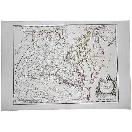
Carte De La Virginie Et Du Maryland Dressee sur la grande carte Angloise de Mrs. Josue Fry et Pierre Jefferson (First State, with Lord Fairfax Line Shown), 1755 |
||||||||||||||||||||
|
||||||||||||||||||||
|
|
||||||||||||||||||||
|
Selling price: $...
Please login to see price! Sold in 2017 Missed this item! Be the first to get notified about our newly added listings. Add your name to our mailing list. Feel free to contact us if you have a question about this item. |
Collection - Save and collect this or any of your favorite items in one place.
If you want to save the items permanently, please sign in or create account first. |
|||||||||||||||||||
Description
A copperplate border-colored map of Virginia and Maryland. A striking example of the single sheet version of the seminal Fry-Jefferson map, engraved by Elisabeth Haussard and published in Paris by Robert De Vaugondy, for the 'Atlas Universel.'
A well-executed reduction of Joshua Fry and Peter Jefferson's landmark map was originally issued separately and later appeared in Jefferys' 'American Atlas.'
The result is a beautiful single folio sheet example of Virginia and Maryland's most sought after and recognizable 18th Century map. While the title is in French, virtually all of the place names and annotations are in English. The map provides a fabulously detailed look into pre-revolutionary war Virginia and Maryland, extending west to the Alleghany Mountains, and including Delaware and a portion of New Jersey, as well as the region around Philadelphia.
Originally prepared by Joshua Fry of William & Mary and Peter Jefferson (father of President Thomas Jefferson), at the request of Lord Halifax in 1748, the Fry-Jefferson was a monumental leap forward in the mapping of the region. It is the first map to accurately depict the Blue Ridge Mountains and the first to lay down the colonial road system of Virginia. Many plantations are located and include the family names of the Virginia plantation owners of the period. The cartouche, showing a tobacco warehouse and wharf, is one of the earliest printed images of the Virginia tobacco trade.
One of the first actions of Lord Halifax, upon becoming president of the Board of Trade and Plantations in 1748, was to request information concerning activities in the Frontiers and of potential French encroachments on the British territorial claims. In 1750, the Board required that each colony conduct a comprehensive survey. The acting Governor of Virginia, Col. Lewis Burwell, commissioned Fry & Jefferson to prepare a map of the Virginia colony.
Joshua Fry, a mathematician at the College of William and Mary, and Peter Jefferson, a surveyor, had previously drawn the boundaries of Lord Fairfax's lands in 1746 and surveyed the Virginia-North Carolina boundary in 1749. First issued in 1751, the Fry-Jefferson map incorporates the original surveys of Fry & Jefferson with existing data.
A major revision in 1755 incorporated important information about the western part of the colony from the journals of John Dalrymple and Christopher Gist, the latter of whom is credited in the upper left part of the map with having contributed to the revisions. It is the 1755 edition that forms the basis for the subsequent editions.
Reference: Phillips Atlases 619. Swem 184. Pedley 470, State 1.
FAQ - Guarantee - Shipping
Buying in the BuyNow Gallery
This item is available for immediate purchase when a "Add to Cart" or "Inquire Now" button is shown.
Items are sold in the EU margin scheme
Payments are accepted in Euros or US Dollars.
Authenticity Guarantee
 We provide professional descriptions, condition report (based on 45 years experience in the map business)
Paulus Swaen warrants the authenticity of our items and a certificate of authenticity is provided for each acquired lot.
Condition and Coloring
We indicate the condition of each item and use our unnique HiBCoR grading system in which four key items determine a map's value: Historical Importance, Beauty, Condition/Coloring and Rarity.
Color Key
We offer many maps in their original black and white condition. We do not systematically color-up maps to make them more sellable to the general public or buyer.
Copper engraved or wood block maps are always hand colored. Maps were initially colored for aesthetic reasons and to improve readability. Nowadays, it is becoming a challenge to find maps in their original colors and are therefor more valuable.
We use the following color keys in our catalog:
Original colors; mean that the colors have been applied around the time the map was issued.
Original o/l colors; means the map has only the borders colored at the time of publication.
Colored; If the colors are applied recently or at the end of the 20th century.
Read more about coloring of maps [+]
Shipping fee
A flat shipping fee of $ 30 is added to each shipment by DHL within Europe and North America. This covers : International Priority shipping, Packing and Insurance (up to the invoice amount).
Shipments to Asia are $ 40 and rest of the world $50
We charge only one shipping fee when you have been successful on multiple items or when you want to combine gallery and auction purchases.
Read more about invoicing and shipping
FAQ
Please have a look for more information about buying in the BuyNow gallery
Many answers are likely to find in the general help section.
Collection
![]()
With Collection you can collect all your favorite items in one place. It is free, and anyone can create his or her Virtual map collection.
Unless you are logged in, the item is only saved for this session. You have to be registed and logged-in if you want to save this item permanently to your Virtual Collection.
Read More[+]
Register here, it is free and you do not need a credit card.
Add this item to
Virtual Collection
or click the following link to see my Collection.
| Digital Image Download | |
|
Paulus Swaen maintains an archive of most of our high-resolution rare maps, prints, posters and medieval manuscript scans. We make them freely available for download and study. Read more about free image download |
Click the image for a free small image download. |
In accordance with the EU Consumer Rights Directive and habitually reside in the European Union you have the right to cancel the contract for the purchase of a lot, without giving any reason.
The cancellation period will expire 14 calendar days from the day after the date on which you or a third party (other than the carrier and indicated by you) acquires, physical possession of the lot. To exercise the right to cancel you must inform Paulus Swaen Inc, of your decision to cancel this contract by a clear statement (e.g. a letter sent by post, or e-mail (amsterdam@swaen.com).
To meet the cancellation deadline, it is sufficient for you to send your communication concerning your exercise of the right to cancel before the cancellation period has expired.
![[Lot of 2 maps] Kaart van de onderkoningschappen van Mexico en Nieuw Granada/ Carte de l'Isle de la Martinique, / antique map of the main Carabean islands] Cuba Insula, inset: Havanna portus; Hispanolia Insula.](/uploads/cache/19646-(1)-250x250.jpg)
