Subscribe to be notified if similar examples become available.

Atlas géographique des quatre parties du monde. |
||||||||||||||||||||
|
||||||||||||||||||||
|
|
||||||||||||||||||||
|
|
My Collection + - Save and collect this or any of your favorite items in one place.
If you want to save the items permanently, please sign in or create account first. |
|||||||||||||||||||
Description
Interesting atlas printed during the French Revolution (1789-1799) by Ph. Dezauche. The title cartouche of the newly made map (6bis) "Carte de France, suivant sa nouvelle division en LXXXVIV départements. . . 1794." shows a cock holding a sword and [bonnet rouge] or liberty cap [bonnet de la liberte].
Most maps are prepared by Philippe Buache, who was one of the most active proponents of the so-called school of theoretical cartography active in mid-18th century France.
This atlas contains several note worthy maps :
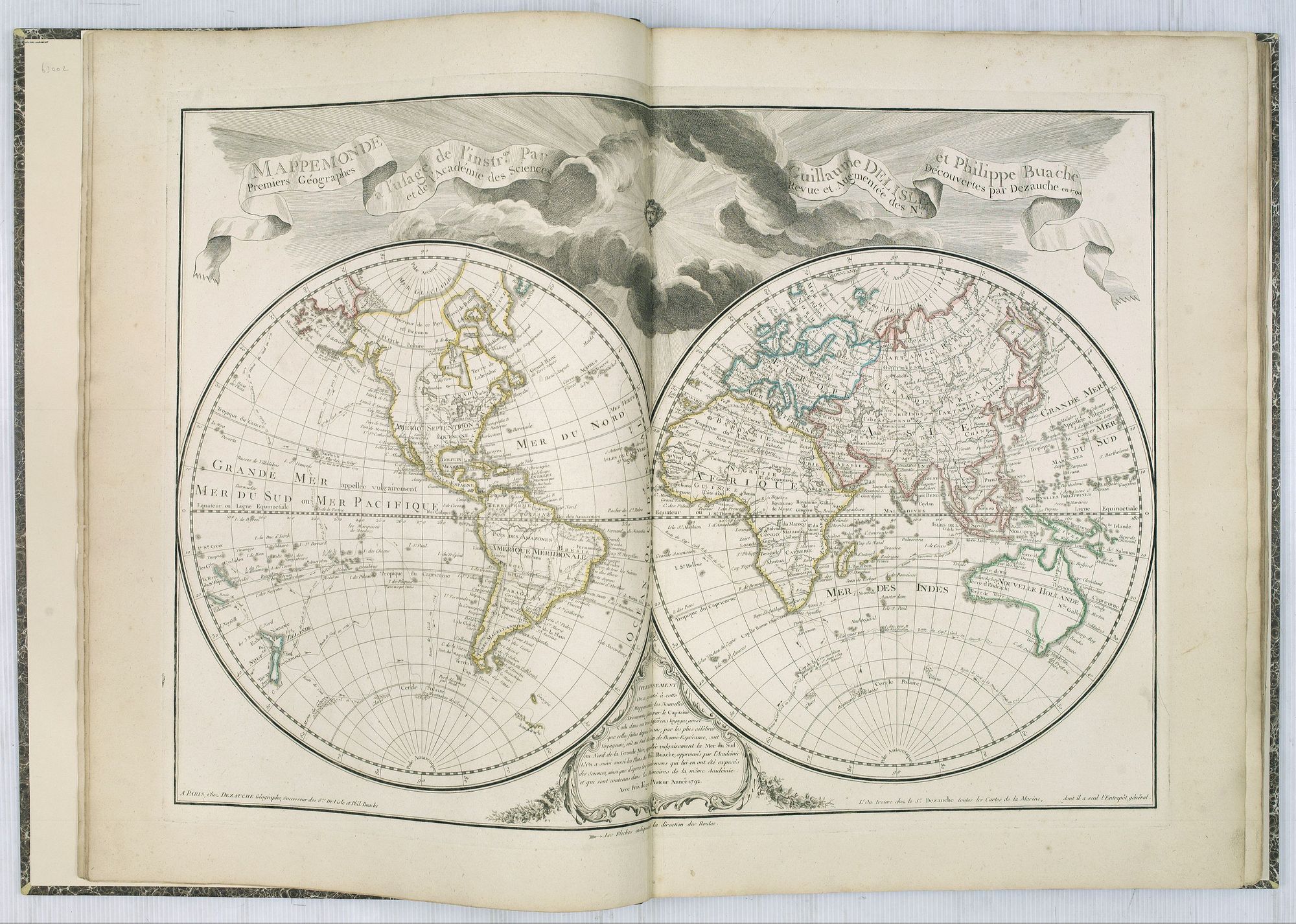
- Interestingly the "Mappemonde" has the original dedication to the King removed as the map was created during the French Revolution. - Mappemonde a l'usage de l'instr.on. Par Guillaume Delisle et Philippe Buache. (An updated version of the double hemisphere world map by Buache of 1785.
Decorative world map with curious delineation of Alaska.
Showing the tracks of Capt. Cook. Van Diemen's Land connected to mainland Australia.
The complete title is divided over two garlands : Mappemonde a l'usage l'instr.on par Guillaume Delisle et Philippe Buache Premiers Géographes et de l'Acad'emie des Sciences. Revue et augmentée des N les Découvertes par Dezauche en 1790.
With a privilege for the year 1792. It shows the latest discoveries - Australia and New Zealand are complete, Japan is more or less accurately depicted, and the routes of Captain Cook are shown. Title on ribbon extending across top of print, with face of the sun dramatically shining through dark clouds at upper centre.
Planisphere Physique Où l'on voit du Pole Septentrional.(Projection au pôle nord.
Flanquée de tables explicatives. - Uncommon world map on a north pole projection prepared by G.de l'Isle and published by Phil. Dezauche. This map is most notable for it's depiction of Mer de L'Ouest or Sea of the West, a great sea, easily the size of the Mediterranean, to flow from the then-known Strait of Juan de Fuca. He also shows an opening to the ocean from this great sea at roughly in North California or Oregon and Quivira somewhere in Idaho. Showing tracks of Tasman, Magellan, Drake, Quiros, etc. Only Australia's west coast is drawn in. 340x440mm.)
- Carte physique de ou geographie naturelle de la France, divisee par chaines de montagnes et aussi par terreins de fleuves et rivieres. Presente en MSt. a l'Acade. des Sciences en 1744 et 1752. Par Phil. Buache, 1er. Geographe du Roi. Publiee en 1770 avec l'approbation et sous le privilege de l'Acade. . .
- Nouveau plan routier de la ville et fauxbourgs de Paris. . . chez Esnauts & Rapilly. . . 1793)
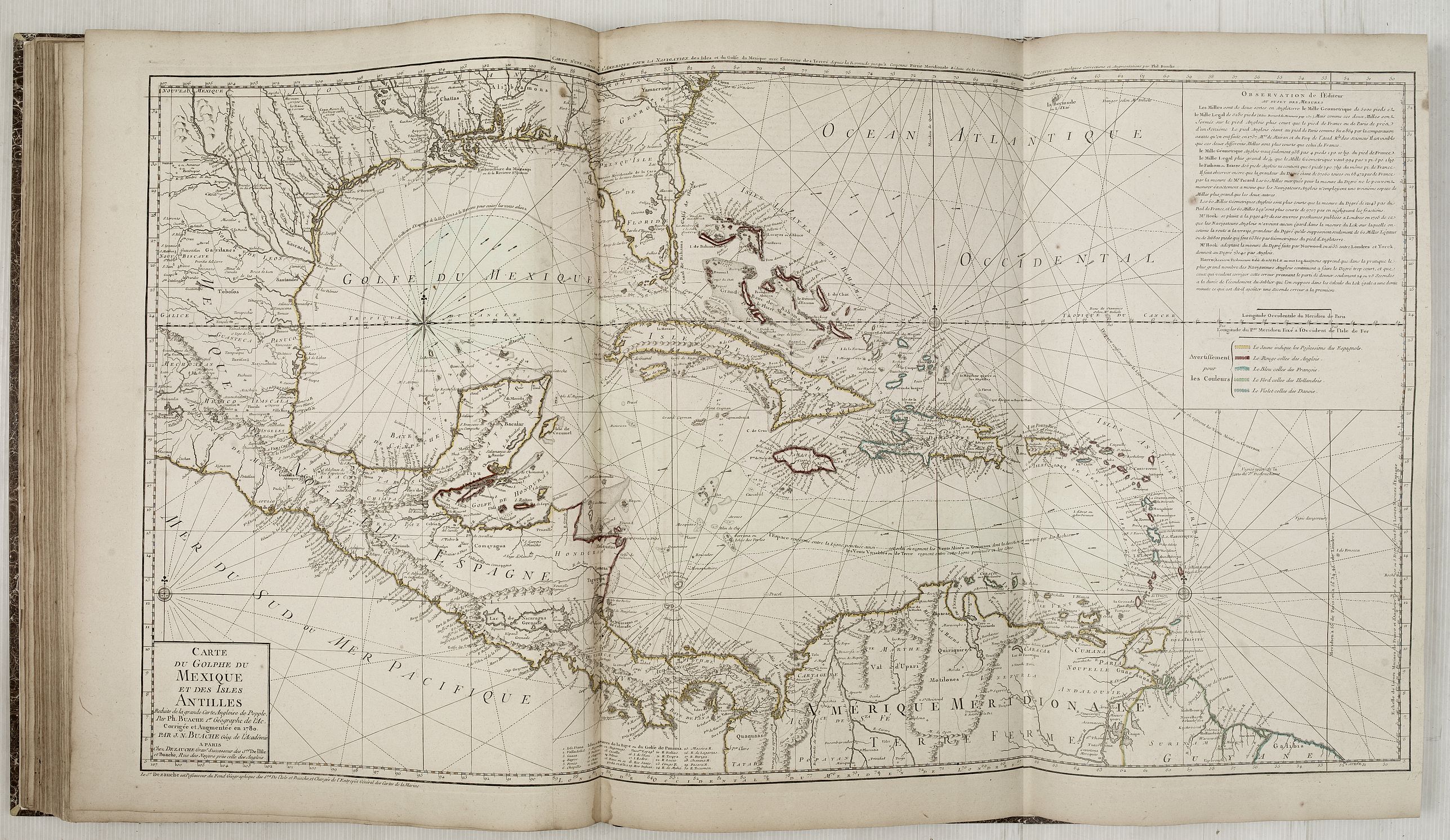
Carte du Mexique et des Etats Unis d'Amérique. . . (De l'Isle's map, but updated in the year 1783 at the ending of the American Revolutionary War. A newly added color key indicating American, English, French and Spanish possessions. Showing the explorations of d'Iberville and his men on the Gulf Coast and the lower reaches of the Mississippi and Red rivers, and the Indian villages in East Texas where the Spanish constructed their missions and presidios. Route of the Spanish gold and silver fleets shown. Tooley, America, L'Isle, 53.)
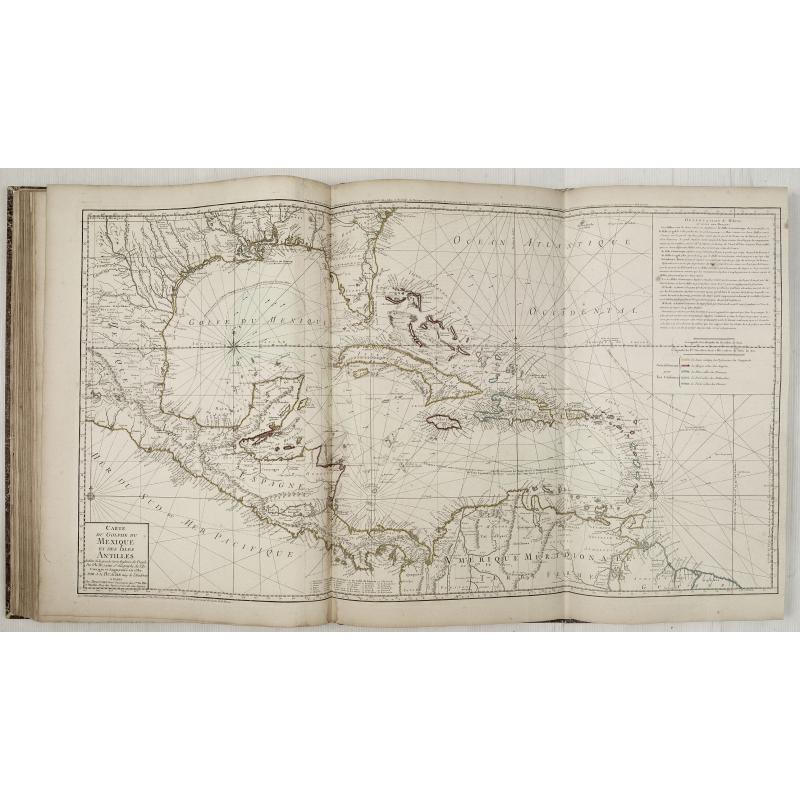
Carte du Golphe du MEXIQUE et des Isles Antilles Réduite de la grande Carte Angloise de Popple, Par Ph. Buache... Corrigée et Augmentée en 1780, Par J.N.Buache ... (Reissued with a new title. Also added to the plate is an engraved table of the colors to be used for distinguishing the possessions of the different nationalities, yellow for Spanish, red for English, blue for French, green for Dutch and violet for the Danes. Tooley, America, page, 29, 92)
-
The Europe map is dated 1788 but the coats of arms in the title cartouche are covered with black ink.
Philippe Buache de la Neuville was born in Neuville-en-Pont (France) on 7th February 1700 and studied at the Académie des Sciences, where he won the first prize for architecture in 1721.
He subsequently joined the Ministry of the Navy, where his drafting skills enabled him to concentrate on cartography. In 1729 he became geographer to the king, then geographer in the Académie des Sciences, successor to his former teacher and father-in-law, Guillaume Delisle (1675-1726). He pioneered a new form of theoretical geography and, in 1755, was appointed Professor of Geography.
More than a copyist, Buache was an academic geographer who researched his material thoroughly, relying on the most up-to-date information from voyages of discovery. He was the first geographer to recognize the important concept of the watershed and it was this that led him to make a number of deductions, some correct, some not.
Buache was trained under the geographer Guillaume Delisle, whose daughter he married, and whom he succeeded in the Académie des sciences in 1730. Buache was nominated first geographer of the king in 1729. He established the division of the world by seas and river systems. He believed in a southern continent, an hypothesis which was confirmed by later discoveries. In 1754, he published an "Atlas physique."
His nephew, Jean Nicolas Bauche (born La Neuville-au-Pont, 15 February 1741 and died Paris, 21 November 1825), continued his business and was also a geographer of the king.
Contents of the atlas:
1/ Title page
2/ Catalogue
3/ Mappemonde
4/ Planisphère
5/ Europe
6/ La France divisée par gouvernemens.
7/ France phisique ou géographie naturelle
9/ Prevôté, Vicomté et environ de Paris
10/ Pays Bas catholique
11/ Les provinces unies, ou Hollande
12/ Les isles Britanniques, ou royaume d'Angleterre?
13/ Le Dannemarck
14/15/ Les couronnes du Nord? Norwege
16/17/ La Russie ou Moscovie.
18/ La Pologne...
19/ L'Allemagne.
20/ La Suisse.
21/ La Savoie, par le père Placide.
22/23/ Le Piémont et Montferat.
24/ L'Italie.
25/ L'Espagne et Portugal.
26/ La Hongrie et Turquie d'Europe Septentrionale.
27/ La Grece où Turquie d'Europe Méridionale.
28/ L'Asie.
29/ Turquie, Arabie et Perse.
30/ Les Indes, la Chine et les Isles d'Asie.
31/ L'Afrique.
33/ Canada et partie Septentrionale des Etats Unis d'Amérique.
34/ Mexique et partie Méridionale des Etats Unis d'Amérique.
35/ Le golfe du Mexique et des Isles Antilles.
36/ Theatrum historicum et Empire Romain, pars Occidentalis.
37/ Theatrum Historicum et Empire Romain, pars Orientalis.
38/ Carte de l'Histoire Sainte pour les premiers âges du Monde.
39/ La Terre Sainte divisée par Tribus
FAQ - Guarantee - Shipping
Buying in the BuyNow Gallery
This item is available for immediate purchase when a "Add to Cart" or "Inquire Now" button is shown.
Items are sold in the EU margin scheme
Payments are accepted in Euros or US Dollars.
Authenticity Guarantee
 We provide professional descriptions, condition report (based on 45 years experience in the map business)
Paulus Swaen warrants the authenticity of our items and a certificate of authenticity is provided for each acquired lot.
Condition and Coloring
We indicate the condition of each item and use our unnique HiBCoR grading system in which four key items determine a map's value: Historical Importance, Beauty, Condition/Coloring and Rarity.
Color Key
We offer many maps in their original black and white condition. We do not systematically color-up maps to make them more sellable to the general public or buyer.
Copper engraved or wood block maps are always hand colored. Maps were initially colored for aesthetic reasons and to improve readability. Nowadays, it is becoming a challenge to find maps in their original colors and are therefor more valuable.
We use the following color keys in our catalog:
Original colors; mean that the colors have been applied around the time the map was issued.
Original o/l colors; means the map has only the borders colored at the time of publication.
Colored; If the colors are applied recently or at the end of the 20th century.
Read more about coloring of maps [+]
Shipping fee
A flat shipping fee of $ 30 is added to each shipment by DHL within Europe and North America. This covers : International Priority shipping, Packing and Insurance (up to the invoice amount).
Shipments to Asia are $ 40 and rest of the world $50
We charge only one shipping fee when you have been successful on multiple items or when you want to combine gallery and auction purchases.
Read more about invoicing and shipping
FAQ
Please have a look for more information about buying in the BuyNow gallery
Many answers are likely to find in the general help section.
My Collection+
![]()
With My Collection+ you can collect all your favorite items in one place. It is free, and anyone can create his or her virtual collection.
Unless you are logged in, the item is only saved for this session. You have to be registed and logged-in if you want to save this item permanently to My Collection+.
Read More[+]
Register here, it is free and you do not need a credit card.
Add this item to
My Collection+
or click the following link to see My Collection+.
| Digital Image Download | |
|
Paulus Swaen maintains an archive of most of our high-resolution rare maps, prints, posters and medieval manuscript scans. We make them freely available for download and study. Read more about free image download |
Click the image for a free small image download. |
In accordance with the EU Consumer Rights Directive and habitually reside in the European Union you have the right to cancel the contract for the purchase of a lot, without giving any reason.
The cancellation period will expire 14 calendar days from the day after the date on which you or a third party (other than the carrier and indicated by you) acquires, physical possession of the lot. To exercise the right to cancel you must inform Paulus Swaen Inc, of your decision to cancel this contract by a clear statement (e.g. a letter sent by post, or e-mail (amsterdam@swaen.com).
To meet the cancellation deadline, it is sufficient for you to send your communication concerning your exercise of the right to cancel before the cancellation period has expired.
