Subscribe to be notified if similar examples become available.
Arnsberg. |
||||||||||||||||||||
|
||||||||||||||||||||
|
|
||||||||||||||||||||
|
Selling price: $ Please login to see price!
Sold in 2020 Missed this item! Add your name to our mailing list and be the first to get notified about our newly added listings. . |
My Collection + - Save and collect this or any of your favorite items in one place.
If you want to save the items permanently, please sign in or create account first. |
|||||||||||||||||||
Description
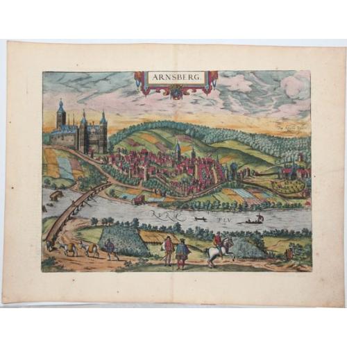
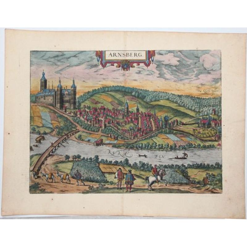
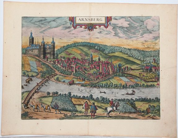
Bird's-eye view of Arnsberg by Braun and Hogenberg.
COMMENTARY BY BRAUN: "The fair and noble land of Westphalia between the Weser and the Rhine stretches all the way to the land of Hesse and in the north as far as Friesland. It is divided into many different counties, duchies and noble estates. [...] One of these is the County of Arnsberg, not the least in renown and merit, whose lords and counts, especially Frederick, [...] also called themselves Counts of Westphalia."
In this view of the city, which is laid out in elliptical form on the narrow ridge of a hill in the Rhenish Uplands within a narrow loop of the Ruhr, the dominating feature is the castle, built in the 11th century by the Counts of Arnsberg, and considerably expanded in the 14th century by the Electors of Cologne. The city was fortified with walls and towers. At the southern end of it was the monastery of Winckhusen dating from the 15th century, which later became the abbey of Wedinghausen.
In 1600 the city was destroyed by fire, but by 1632 it already had 227 households again. The castle was destroyed in 1762 by the Prince of Brunswick during the Seven Years' War. The plate emphasizes the city's key position on various important routes: the main road from Soest leads over a guarded bridge to the city, and the Ruhr, which flows past the city, is navigable for merchant ships. The figures in the foreground illustrate the city's position of power: nobleman, knight and guard. (Taschen)
More about Braun and Hogenberg, Civitatus [+]
Reference: Van der Krogt 4, 251; Taschen, Braun and Hogenberg, p.300.
FAQ - Guarantee - Shipping
Buying in the BuyNow Gallery
This item is available for immediate purchase when a "Add to Cart" or "Inquire Now" button is shown.
Items are sold in the EU margin scheme
Payments are accepted in Euros or US Dollars.
Authenticity Guarantee
 We provide professional descriptions, condition report (based on 45 years experience in the map business)
Paulus Swaen warrants the authenticity of our items and a certificate of authenticity is provided for each acquired lot.
Condition and Coloring
We indicate the condition of each item and use our unnique HiBCoR grading system in which four key items determine a map's value: Historical Importance, Beauty, Condition/Coloring and Rarity.
Color Key
We offer many maps in their original black and white condition. We do not systematically color-up maps to make them more sellable to the general public or buyer.
Copper engraved or wood block maps are always hand colored. Maps were initially colored for aesthetic reasons and to improve readability. Nowadays, it is becoming a challenge to find maps in their original colors and are therefor more valuable.
We use the following color keys in our catalog:
Original colors; mean that the colors have been applied around the time the map was issued.
Original o/l colors; means the map has only the borders colored at the time of publication.
Colored; If the colors are applied recently or at the end of the 20th century.
Read more about coloring of maps [+]
Shipping fee
A flat shipping fee of $ 30 is added to each shipment by DHL within Europe and North America. This covers : International Priority shipping, Packing and Insurance (up to the invoice amount).
Shipments to Asia are $ 40 and rest of the world $50
We charge only one shipping fee when you have been successful on multiple items or when you want to combine gallery and auction purchases.
Read more about invoicing and shipping
FAQ
Please have a look for more information about buying in the BuyNow gallery
Many answers are likely to find in the general help section.
My Collection+
![]()
With My Collection+ you can collect all your favorite items in one place. It is free, and anyone can create his or her virtual collection.
Unless you are logged in, the item is only saved for this session. You have to be registed and logged-in if you want to save this item permanently to My Collection+.
Read More[+]
Register here, it is free and you do not need a credit card.
Add this item to
My Collection+
or click the following link to see My Collection+.
| Digital Image Download | |
|
Paulus Swaen maintains an archive of most of our high-resolution rare maps, prints, posters and medieval manuscript scans. We make them freely available for download and study. Read more about free image download |
Click the image for a free small image download. |
In accordance with the EU Consumer Rights Directive and habitually reside in the European Union you have the right to cancel the contract for the purchase of a lot, without giving any reason.
The cancellation period will expire 14 calendar days from the day after the date on which you or a third party (other than the carrier and indicated by you) acquires, physical possession of the lot. To exercise the right to cancel you must inform Paulus Swaen Inc, of your decision to cancel this contract by a clear statement (e.g. a letter sent by post, or e-mail (amsterdam@swaen.com).
To meet the cancellation deadline, it is sufficient for you to send your communication concerning your exercise of the right to cancel before the cancellation period has expired.
