Browse Listings in Map Types
![Madeburga [ Maagdenburg Folio CLXXX ]](/uploads/cache/47601-250x250.jpg)
Madeburga [ Maagdenburg Folio CLXXX ]
Double page panoramic view of Magdeburg. A imaginary view, however the earliest obtainable view of this period.Two page from the richest illustrated Incunable, the famous...
Date: Nuremberg, 12 July 1493
![[Lot of 10 leaves] Catalogus doctorum…in Cosmographia Sebastiani…/ Index Cosmographicus.](/uploads/cache/48294-250x250.jpg)
[Lot of 10 leaves] Catalogus doctorum…in Cosmographia Sebastiani…/ Index Cosmographicus.
Ten leaves with several wood blocks with index taken from the "Cosmographia". From the 1552 Latin text edition of Münster's Cosmographia, which is a short and ...
Date: Basel, 1552
![[Sea monsters] De regni Settentrionali Monstri marini & terrestri…](/uploads/cache/49169-250x250.jpg)
[Sea monsters] De regni Settentrionali Monstri marini & terrestri…
Münster's plate of monsters of both land and sea, taken from an Italian text edition of Münster's Cosmographia, which is a short and complete summary of Renaissance kno...
Date: Basel, 1558
![[Two plates on one sheet] Ordinanza Turchesa alla presa di Zigeth in Ongaria l’anno 1566 / Ordinanza Turchesca sotto Viena, contra lo Invictißimo Imperatore Carlo quinto l'anno 1550.](/uploads/cache/49073-250x250.jpg)
[Two plates on one sheet] Ordinanza Turchesa alla presa di Zigeth in Ongaria l’anno 1566 / Ordinanza Turchesca sotto Viena, contra lo Invictißimo Imperatore Carlo quinto l'anno 1550.
Ordinanza Turchesca sotto Viena, contra lo Invictißimo Imperatore Carlo quinto l'anno 1550". C. 1560. This extremely rare plate depicts the order of battle and for...
Date: Venice, 1550/ 1566
![[Title page for] Theatrum Orbis Terrarum.](/uploads/cache/47940-250x250.jpg)
[Title page for] Theatrum Orbis Terrarum.
A decorative title page of the first atlas ever made shows five female figures as allegorical representatives of the continents, grouped around the title. According to P...
Date: Antwerp, after 1570

Slusa, Teutonicae Flandriae opp. . . (Sluis)
Bird'eye view of the town of Sluis.From the greatest publication in this genre!. The Civitates was compiled and written by George Braun, Canon of Cologne Cathedral. Braun...
Date: Cologne, 1580
![[Title page] De Praecipuis, Totius Universi Urbibus, Liber Secundus.](/uploads/cache/47934-250x250.jpg)
[Title page] De Praecipuis, Totius Universi Urbibus, Liber Secundus.
Allegorical title page, from Volume 2 of Braun & Hogenberg's Civitatus Orbis Terrarum.At the top are figures representing Religion and Politics, placed on either side...
Date: Cologne, 1582

Mercurius.
Mercury holding a caduceus and riding in a chariot drawn by two birds on the clouds in the sky, an extensive landscape with a harbor with goods being loaded and unloaded ...
Date: Antwerp, 1585
Selling price: ????
Please login to see price!
Sold in 2025

Caerte der Noordt cufte van Engelandt, beginnende van Robinhodes baij tot Coket Eijlandt. . . .
A very early Dutch text edition of this detailed chart of the northern coast of England. The mileage cartouche has no Latin captures. West to the top.Decorated by a color...
Date: Leiden, Plantijn, 1585

De custen van een deel van Denemarken en Swede. . .
A detailed chart of the coast Skane and Kalmar, with the island Öland. Decorated by a title and scale cartouche, a compass rose, several vessels and sea monsters, and de...
Date: Leiden, Plantijn, 1585

Novus de Leone Belgico eiusq topographia atq. Historica descriptione liber (…). Rerumque in Belgio maxime gestarum, inde ab anno Christi M.D.LIX. Usque ad annum M.D.LXXXVII perpetua narratione continatus.
ENLARGED EDITION, with 207 (of 208) engravings of a famous eyewitness account of the Dutch Revolt, with the famous "Leo Belgicus" map, here in its second state...
Date: Cologne, Gerardus Campensis for Frans Hogenberg, 1588

ABRAHAMUS ORTELIUS ANTVERPIANUS Orteli dum proponis spectantibus Orbem, Quam tua delectant structa Theatra homines! . . .
Portrait of Abraham Ortelius (Abraham Ortel), famous cartographer born in Antwerp and after studying Greek, Latin and mathematics set up business there with his sister, a...
Date: Antwerp, c.1595

Christophorus Columus Ligur Indiarum Prim invet A°1492
Very decorative portrait of Christopher Columbus (c. 31 October 1451 – 20 May 1506), engraved by Theodor de Bry (1528-1593) and published in Jean Jacques Boissard, &quo...
Date: Frankfurt a.M. 1597 - 1599
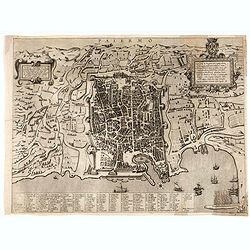
Palermo.
Rare bird's-eye view of Palermo, the plan showing the city and harbor within the city walls, with the surrounding countryside, title and dedicatory verse set in elaborate...
Date: Seina, ca. 1600

Le Nouveau miroir des voiages marins de la navigation de la mer occidentale & orientale.
A second and final French edition of this important sea atlas. Two engraved frontispieces, figure with volvelle, full-page figure, 48 double-page charts (one numbered 19....
Date: Antwerp, Chez Iean Bellere, a l’Aigle d’or, l’An M.CCCCCC (1600
![[Title page] Perspective die hooch-gheroemde conste..](/uploads/cache/25554-250x250.jpg)
[Title page] Perspective die hooch-gheroemde conste..
Title page from Perspective, Dat is, de hooch-gheroemde conste eens schijnende in oft door-siende ooghen-ghesichtespunt ... (&c.) by Hans, or Johannes Vredeman de Vri...
Date: Leiden, 1604
![[Title page] Geographiae libri octo Graeco-Latini . . .](/uploads/cache/47936-250x250.jpg)
[Title page] Geographiae libri octo Graeco-Latini . . .
Fine decorative titlepage from the 1605 edition of Ptolemy. The plate is adorned with allegorical figures, fruits and architectural motifs. This 1605 edition was based on...
Date: Amsterdam, 1605
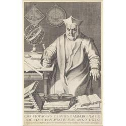
Christophorus Clavius Bambergensis e societate iesu aetatis suae anno LXIX.
Rare portrait of Christopher Clavius or Clau (March 25, 1538 – February 12, 1612) was a German Jesuit mathematician and astronomer who was the main architect of the mod...
Date: Rome, 1606

Germania.
Second state of this rare "carte à figures"- map of Germany, The Netherlands, Poland and central Europe. Bordered on three sides with portraits and views. In t...
Date: Amsterdam, 1607
![[Title page for] Atlas Minor de Guerard Mercator. . .](/uploads/cache/47933-250x250.jpg)
[Title page for] Atlas Minor de Guerard Mercator. . .
Title page from a 1608 French edition of the Atlas Minor (351:11). The title page is similar to that in the Latin edition of 1607, but a slip of paper with the engraved t...
Date: Amsterdam, 1608
![[Title page colored by Georg Mack Jr. to : Hortus Eystettensis, Sive Diligens et Accurata Omnium Plantarum, Florum, Stirpium,. . .]](/uploads/cache/39343-250x250.jpg)
[Title page colored by Georg Mack Jr. to : Hortus Eystettensis, Sive Diligens et Accurata Omnium Plantarum, Florum, Stirpium,. . .]
Title page to the first edition, one of about 300 copies printed, from one of the largest and most magnificent of the great flower books, depicting more than 1000 flowers...
Date: Nuremberg, ca 1613
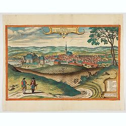
Polna vulgo Polm insign : Bohemia. . .
This is a view of Polna from the southwest, looking across the Bohemian-Moravian Highlands from a slightly elevated viewpoint. In addition to the parish church (D) in the...
Date: Cologne, 1617
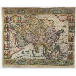
Asia recens summa cura delineata.
This is the rare early issue with decorative paneled borders of four sides. It is surrounded by elaborate borders incorporating twelve bird's eye views of cities and te...
Date: Amsterdam, H.Hondius,1623
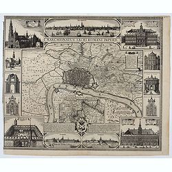
Marchionatus Sacri Romani Imperii.
Plan of the city of Antwerp in Belgium, by Claes Janszoon Visscher and first published by his son. The map is surrounded by 3 city views and 10 building vignettes and inc...
Date: Amsterdam 1624
A Newe mape of Poland Done into English by I.Speede.
A wonderful map of Poland. Incorporated into Speed's 'Prospect Of The Most Famous Parts Of The World'. Includes birds-eye views of Cracow, Dantzick, Posna, Crossen, Sando...
Date: London, 1627

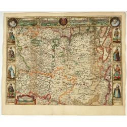
Tabula nova Poloniae et Silesiae.
Second state, dated 1630 underneath the title. A finely engraved carte á figures with cartouche representing in the four corners of the map : Kings ( on the left side Si...
Date: Amsterdam, 1630
![Tabula electoratus Brandenburgici, Meckelenburgi, et maximae partis Pomeraniae, ex variis, famosissimisq[ue] auctoribus summo studio concinnata. . .](/uploads/cache/37545-250x250.jpg)
Tabula electoratus Brandenburgici, Meckelenburgi, et maximae partis Pomeraniae, ex variis, famosissimisq[ue] auctoribus summo studio concinnata. . .
Uncommon "carte à figures"- map engraved by the master engraver Abraham Goos and published by Claes Jansz. Visscher (1587-1652). The map shows the part of west...
Date: Amsterdam, 1630

Comitatus Flandria.
First published by the van Langrens c.1595, after his acquisition of the plate, Visscher heavily re-engraved the map, inserting panelled borders on three sides (the lower...
Date: Amsterdam, c. 1630
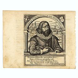
Henricus Kornmannus I.U. Doc. ex Kyrchayna cat.
Very skillfully engraved half-length portrait of Heinrich Kornmann, in frontal view, underneath an arch and with a view of Kirchhain in background and coats-of-arms in up...
Date: Frankfurt, 1630
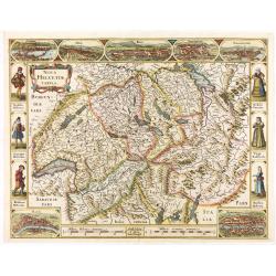
Nova Helvetiae Tabula.
A most decorative "carte à figures" map with panoramic views of Lucern, S.Gal, Bern, Solothurn, Schafhausen in upper border and Basel and Zurich in lower left ...
Date: Amsterdam, 1630
![[Portrait of Gerard Mercator and Jodocus Hondius.]](/uploads/cache/49107-250x250.jpg)
[Portrait of Gerard Mercator and Jodocus Hondius.]
Arguably the finest engraved portrait of early mapmakers. In the well-executed design, Gerard Mercator and Jodocus Hondius are seated within an architectural cartouche of...
Date: Amsterdam, 1630
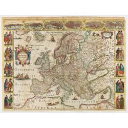
Nova Europae descriptio.
Rare early issue of the map of Europe with the lower border removed and without text on the reverse. Variant: The map no longer has a lower border, no text on the reverse...
Date: Amsterdam, after 1630

Nova Germaniae Descriptio..
A finely engraved carte à figures, with the side borders depicting emperors, while the upper and lower panels contain finely engraved miniature town prospects, among the...
Date: Amsterdam, 1632
![[Title page] Les plans et profils de toutes les principales villes et lieux considerables de France . . .](/uploads/cache/48026-250x250.jpg)
[Title page] Les plans et profils de toutes les principales villes et lieux considerables de France . . .
Title page of the first part of the atlas "Les plans et profils de toutes les principales villes et lieux considerables de France", by Nicolas Tassin.Nicolas Ta...
Date: Paris, 1634

Asia secunda pars in forma Pegasi.
UNRECORDED PLATE or STATE. Asia depicted as the flying horse Pegasus. Below the depiction 3 lines of engraved Latin text. Double page copper engraved map from Heinrich B�...
Date: Brunswick, ca. 1635
Corte ende waerachtige beschrijvinghe van het Fort de Schencken-Schans. . .
Map of the Schencken-Schans fortress printed with text. Text in Dutch and French.
Date: Antwerp, 1635
Brabantia Ducatus.
Second state of this scarce Carte-a-Figures map of Brabant, published by Peter Verbiest in Antwerp, decorated with three-sided panels. This is the variant without a botto...
Date: Antwerp, 1637
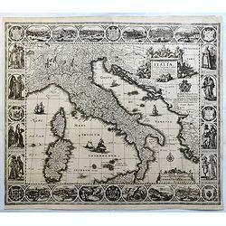
Tabulae Italiae, Corsicae, Sardiniae, et adjacentium..
A decorative map by this famous Dutch mapmaker. The border contains views of the main cities, largely inspired by the Civitates Orbis Terrarum by Braun & Hogenberg: R...
Date: Amsterdam, 1628,1640
![[Ritter Sundial Map of the World]](/uploads/cache/60731-250x250.jpg)
[Ritter Sundial Map of the World]
This highly unusual map projects the world from the north pole as though it were the table of a sundial, with the land masses drawn to scale in proportion to their distan...
Date: Nuremberg, 1640
![[Title page] Le Theatre du Monde ou Nouvel Atlas.](/uploads/cache/06812-250x250.jpg)
[Title page] Le Theatre du Monde ou Nouvel Atlas.
Architectural frontage with the title and imprint printed on paste-on slips.Parts of the item are heightened in gold. Read more about maps heightened in gold
Date: Amsterdam, 1640
![[Title page from ] Le Theatre du Monde ou le nouvel atlas mis en lumière par Guillaume et Jean Blaeu. Troisieme partie.](/uploads/cache/47942-250x250.jpg)
[Title page from ] Le Theatre du Monde ou le nouvel atlas mis en lumière par Guillaume et Jean Blaeu. Troisieme partie.
Frontispiece of " Le Theatre du Monde ou le nouvel atlas mis en lumière par Guillaume et Jean Blaeu. Troisieme partie." Very clear print with nice cartouches a...
Date: Amsterdam, 1640

Wittstocs.
Very decorative and rare panoramic of Wittstock, Bez. Potsdam.The engraver and publisher of prints, Mrs. Anna Beek of the Hague, enlarged the print and mounted it on larg...
Date: The Hague, ca. 1642
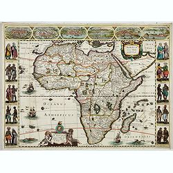
Africa nova Tabula.
Very rare map of Africa separately published. This derivative map by Nicolas Picart is based upon the second state of Janssonius' map of 1623, after the lower border had ...
Date: Paris, 1644
Selling price: ????
Please login to see price!
Sold in 2023
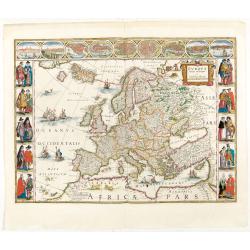
Europa recens descripta à Guilielmo Blaeuw.
On either side columns depicting the manner of dress in the major countries of Europe, surmounted by nine city views and plans.For European mapmakers their own continent ...
Date: Amsterdam, 1644
![[Title page from ] Le Theatre du Monde ou Nouvel Atlas . . .](/uploads/cache/45053-250x250.jpg)
[Title page from ] Le Theatre du Monde ou Nouvel Atlas . . .
A very decorative frontispiece by Willem Blaeu from the second part of this fine atlas. At top, a coat of arms surmounted by a crown and surrounded by two golden chains, ...
Date: Amsterdam, 1644
![[Title page from ] Le Theatre du Monde ou le nouvel atlas mis en lumière par Guillaume et Jean Blaeu. La seconde partie de la premiere.](/uploads/cache/47929-250x250.jpg)
[Title page from ] Le Theatre du Monde ou le nouvel atlas mis en lumière par Guillaume et Jean Blaeu. La seconde partie de la premiere.
Frontispiece of the second part of the first part of this fine atlas. At top, a coat of arms surmounted by a crown and surrounded by two golden chains, the bigger carryin...
Date: Amsterdam, 1644
![[Title page from ] Le Theatre du Monde ou le nouvel atlas mis en lumière par Guillaume et Jean Blaeu. La seconde partie de la seconde.](/uploads/cache/47923-250x250.jpg)
[Title page from ] Le Theatre du Monde ou le nouvel atlas mis en lumière par Guillaume et Jean Blaeu. La seconde partie de la seconde.
Frontispiece of the second part of the second part of this fine atlas. At top, a coat of arms surmounted by a crown and surrounded by two golden chains, the bigger carryi...
Date: Amsterdam, 1644
![[Title page from ] Le Theatre du Monde ou le nouvel atlas mis en lumière par Guillaume et Jean Blaeu.](/uploads/cache/47924-250x250.jpg)
[Title page from ] Le Theatre du Monde ou le nouvel atlas mis en lumière par Guillaume et Jean Blaeu.
Frontispiece of the second part of this fine atlas. At top, a coat of arms surmounted by a crown and surrounded by two golden chains, the bigger carrying a pendant which ...
Date: Amsterdam, 1644
![[Two volumes, with two Leo maps] De Bello Belgico, Decas Prima / Decas Secunda.](/uploads/cache/48779-250x250.jpg)
[Two volumes, with two Leo maps] De Bello Belgico, Decas Prima / Decas Secunda.
With 2 engraved titles of the 'Leo Belgicus', with one paw resting on a shield bearing the title, large woodcut printer's device on the colophons, and 30 richly engraved ...
Date: Rome, Franciscus Corbelletus, 1632-1647

Profil de la renomée ville et port d'Emstredam cappitalle des estats de Hollande.
Extremely rare panoramic town-view of Amsterdam seen from the river IJ.Exceptional bright, sharp example.The print is skillful copy of the print of Matthieu Merian, now w...
Date: Paris, 1647
![[ The repositioning of the Vatican obelisk ]](/uploads/cache/49045-250x250.jpg)
[ The repositioning of the Vatican obelisk ]
Joan Blaeu published The Repositioning of the Vatican Obelisk. This large engraving on multiple sheets and in beautiful original colors is based on Domenico Fontana’s d...
Date: Amsterdam, 1649

Curia Hollandiae Interior. (Binnenhof)
The government center of the Netherlands is situated in and around the Binnenhof-Buitenhof in The Hague. In 1248 the Roman king Willem II built a castle here and named it...
Date: Amsterdam, 1649
![[Title page for ] Atlas de la Terre ou Monde Terrestre - Tome premier]](/uploads/cache/47761-250x250.jpg)
[Title page for ] Atlas de la Terre ou Monde Terrestre - Tome premier]
Title page of " Atlas de la Terre ou Monde Terrestre - Tome premier" by J. Jansonius. This is the updated version of 1:42B. The figures of the king, queen, daup...
Date: Amsterdam, after 1650
![[Title page from Theatrum orbis Terrarum, with past-on]](/uploads/cache/43860-250x250.jpg)
[Title page from Theatrum orbis Terrarum, with past-on]
The frontispiece of the third part of the 'Theatrum', by Johan Blaeu. Heightened with goldDecorated with terrestrial and celestial globes and to the left Ptolemy (with sp...
Date: Amsterdam, ca. 1650

Americae Nova Descriptio.
Final state. According to Philip Burden, "this scarce map is America's first single-sheet map with decorative borders." A re-issue of the 1614 plate by Pieter v...
Date: Amsterdam, 1652
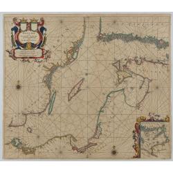
Oost Zee door Arnold Colom.
Large double-page engraved chart of the Baltic Sea, including the coastlines of Finland, Estonia, Latvia, Lithuania, Poland, Denmark, and Sweden, with a decorative inset ...
Date: Amsterdam, c. 1654
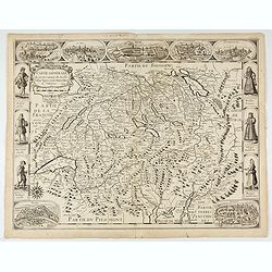
Carte generale des treze cantons de Suisses. Valley Ligues Grise, Maison Dieu et Valteline. 1654
Rare figured border map of Switzerland. In lower corners views of Basel and Zurich. In the top views of Luzern, St. Gallen, Bern, Solothurn and Schaffhausen. In the left ...
Date: Paris, ca. 1654

Wassende graade paskaart vertonende alle de Zeekusten van Europa, de geheele middelandsche Zee…
Wassende graade paskaart vertonende alle de Zeekusten van Europa, de geheele middelandsche Zee, als cock ten Noordwesten, en Noordoosten soo veer als ons tot noch toe bek...
Date: Amsterdam, 1658

Insula Huaena sive Venusia a Guiljelmo Blaeu cum sub Tychone Astronomiae operam ...
Decorative map of the island Hvan in the Danish Sound. In the center Tycho Brahe's famous observatory Uraniborg established in 1576, under the patronage of Frederick II, ...
Date: Amsterdam, 1659
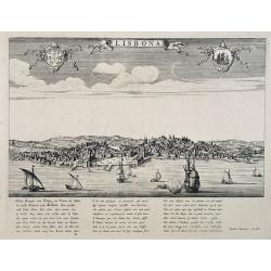
Lisbona.
A rare panoramic view of Lisbon with over the whole length of the lower part 3 columns of poems in Latin, Dutch and French.Published by Dancker Danckerts (1634-1666)Colle...
Date: Amsterdam, 1660

De Texel Stroom .. vant Marsdiep./ Caarte van De Mase...
Two decorative charts on one sheet, one depicting Texel and the entrance of the Zuider Zee with an inset showing the north coast of West-Friesland, the other depicting th...
Date: Amsterdam, 1660

Nova Africa descriptio.
A beautifully engraved and most attractive "carte à figures"- map of the African continent. Bordered, above, by panels showing panorama's of Cairo, Alexandria,...
Date: Amsterdam, after 1660

De Tesselstroom met de Gaten van Marsdiep./ De Mase met. . .
Three charts on one sheet depicting the entrances to the Zuiderzee between Holland, Texel and Vlieland. The entrances of the Maas with Rotterdam and in a small inset the ...
Date: Amsterdam, 1662

Nova XVII Provinciarum Inferioris Germaniae descriptio .
Extremely rare map of the Benelux by Frederick de Widt. Originally engraved and published by P.Kaerius in 1607. In 1662 the plate came in the possession of Frederick de W...
Date: Amsterdam, 1662

Pascaert van Engelant Van t'Voorlandt tot aen Blakeney waer in te sien is de mont vande Teemse.
Two charts on one sheet. One decorative sea chart of the southeast coast of England with an inset of the Thames till London, embellished with two title cartouches, a ship...
Date: Amsterdam, 1666

Noordoost Cust van Asia van Japan tot Nova Zembla.
Important for its early depiction of Hokkaido and the Islands to the North of Japan. Ships navigate the seas around the Siberian, Chinese and Japanese coast extending as ...
Date: Amsterdam, 1666

Pascaerte Van't Westelyckste der Middelandsche Zee. . .
An eye-catching chart of the western part of the Mediterranean Sea.Pieter Goos (ca. 1616-1675) was one of the most important cartographer, engraver, publisher and print s...
Date: Amsterdam, 1666
Pascaart..de Zuyder-Zee, Texel..Vlie-stroom..'t Amelander…
An eye-catching chart of the Zuiderzee with east to the top.Pieter Goos (ca. 1616-1675) was one of the most important cartographer, engraver, publisher and print seller o...
Date: Amsterdam, 1666

Pas-Caart van de Oost Zee verthooende alle de ghelegenheydt tusschen t Eylandt Rugen ende Wyborg. . .
An eye-catching chart of the Baltic Sea. Engraved by Gerard Coeck.Pieter Goos (ca. 1616-1675) was one of the most important cartographers, engravers, publishers and print...
Date: Amsterdam, 1666

Het Canaal tusschen Engeland en Vranciick.
An eye-catching chart of the Channel.Pieter Goos (ca. 1616-1675) was one of the most important cartographers, engravers, publishers and print sellers of Amsterdam. His wi...
Date: Amsterdam, after 1666
Pascaart van de zee-custenvan Angola, en Cimbedas van Rivier de Galion tot C. de Bona Esperanca.
Rare Doncker's sea chart of the West Coast of Africa, from Angola to the Cape of Good Hope, with a larger inset map of the area from St. Martin's Bay to the Cape of Good ...
Date: Amsterdam, 1660-1668

Paskaart van Guinea van C.Verde tot R. deGalion.
Rare edition of Doncker's sea chart of Guinea coast. From an atlas printed in 1668, "l'Atlas de MER ou MONDE AQUATIQUE, Remontrant toutes lescôtes de la Mer…"...
Date: Amsterdam, 1660-1668
![[Title page to] Atlas mayor, o geographia Blaviana : Que contiene las cartas, y descripciones de Partes Orientales de Europa.](/uploads/cache/29952-250x250.jpg)
[Title page to] Atlas mayor, o geographia Blaviana : Que contiene las cartas, y descripciones de Partes Orientales de Europa.
Title page from a Spanish text edition of the Atlas Major. Ionic portico with celestial and terrestrial globes. To the left is Ptolemy with a sphere and a pair of compass...
Date: Amsterdam, c.1672
The mape of Hungari newly augmented by John Speede.
A wonderful carte-a-figures map of ‘Hungari’, comprising modern-day Hungary and parts of Slovakia. Showing two sets of four costumed figures on each side of the map a...
Date: Londres, Bassett and Chiswell, 1626 / 1676

EUROP, and the cheife Cities contayned therin described. . .
A good impression from an early edition of this famous and decorative "carte à figures"- map from the first world atlas produced by an Englishman - John Speed'...
Date: London, 1627 - 1676
![[Title page] Atlas Tot Amsterdam Bij Iustus Danckers in de Calverstraet inde Damcbaerhrijt.](/uploads/cache/47920-250x250.jpg)
[Title page] Atlas Tot Amsterdam Bij Iustus Danckers in de Calverstraet inde Damcbaerhrijt.
Decorative title page with the figure of Atlas, standing on a globe of the Old World. The left and bottom right corners have animals and people from different parts of th...
Date: Amsterdam, ca. 1680
Selling price: ????
Please login to see price!
Sold in 2024
![[Title page] Le Nouveau & Grand Illuminant Flambeau de la Mer. La troisième partie. …Par Nicolas Jans Vooght.](/uploads/cache/47950-250x250.jpg)
[Title page] Le Nouveau & Grand Illuminant Flambeau de la Mer. La troisième partie. …Par Nicolas Jans Vooght.
Allegoric frontispiece of the third edition of the "Zee-Fakkel" with French text. The "4" from the date 16"89" is in manuscript.
Date: Amsterdam, 1689

Citta, porto, e rada di Brest, e . . . Nella Bretagna . . .
A beautiful and rare map of Bretagne. In top right an inset with the town of Brest.The remarkable Vincenzo Coronelli (1650-1718), encyclopaedist, geographer, inventor and...
Date: Venice, 1690
Seville ville Archiepiscopale et capitale du Royaume d'Andalousie en Espagne. . .
A very decorative and extremely rare town-view of Seville, including a numbered key ( 1- 37) in lower part. Engraved by Pierre-Alexandre Aveline. With "fait par Avel...
Date: Paris, ca.1692

Carte de la Manche. . .
Decorative chart showing the Chanel, with the coastline of France from La Baie de Douarnenez to Dunkerque, and the coastline of England from Stroble head to Manning Tree....
Date: Amsterdam, 1692
