Browse Listings in Europe > British Isles
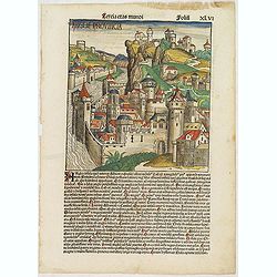
Tercia Etas Mundi. Folium.XLVI (An English town view)
Large woodcut depicting an imaginary English town (235x223mm.) and on the verso the genealogy of King David.Page from the richest illustrated Incunable, the famous: Chron...
Date: Nuremberg, 12 July 1493

De zee cuften tufschen Dovere en Orfords nesse, daer de Teemse de Vermaerde Rivire van Lonen gelegens is. . .
A detailed chart of the English Channel coastland. Decorated by a colorful title cartouche and scale cartouche, one compass rose, several vessels and sea monsters. A very...
Date: Leiden, Plantijn, 1585

Belchrijuinghe vande zee custen van Engelandt. . .
A rare Dutch text edition of this detailed early chart of the northern coast of England. West to the top. The mileage cartouche has no Latin captures. Decorated by a colo...
Date: Leiden, Plantijn, 1585

Caerte der Noordt cufte van Engelandt, beginnende van Robinhodes baij tot Coket Eijlandt. . . .
A very early Dutch text edition of this detailed chart of the northern coast of England. The mileage cartouche has no Latin captures. West to the top.Decorated by a color...
Date: Leiden, Plantijn, 1585

Udrone.
Map depicting present-day County Carlow in Leinster Province & Catherlaugh which is now Carlow. From the first French-text edition of Jodocus Hondius' Atlas Minor.Sho...
Date: Amsterdam, 1608
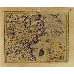
Ultonia Oriental.
Map depicting part of Ulster, with the south-western tip of Scotland in the upper right. From the first French-text edition of Jodocus Hondius' Atlas Minor.Shortly after ...
Date: Amsterdam, 1608
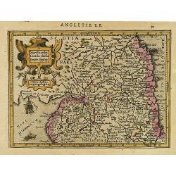
Northumbr. Cumberladia Dunelm. Episcop.
A map of the most northern part of England, from the first French-text edition of Jodocus Hondius' Atlas Minor.Shortly after the publication of the big folio-atlases the ...
Date: Amsterdam, 1608
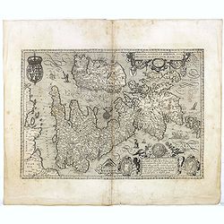
Angliae, Scotiae, et Hiberniae, sive Britannicar : Insularum descriptio.
A rare and ornate map with inset portraits of James First, Henry Prince of Wales Princess Anne of Denmark.Janssonius acquired the copperplate of van den Keere's 1604 Brit...
Date: Amsterdam, 1621

Angliae, Scotiae, et Hiberniae, sive Britannicar : Insularum descriptio.
A rare and ornate map with inset portraits of James First, Henry Prince of Wales Princess Anne of Denmark.Janssonius acquired the copperplate of van den Keere's 1604 Brit...
Date: Amsterdam, 1621
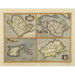
Anglesey. / Iarsay. / Carnesay. / Wight Vectis Olim.
Four maps on one sheet depicting the English islands Jersey, Guernsey, Wright and Alderney.
Date: Amsterdam, 1629
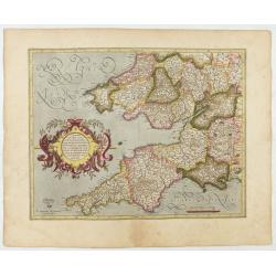
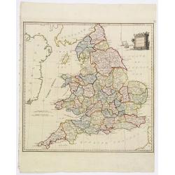
Cornubia, Devonia, Somersetus, . . .
A very nice map showing the south-western part of England. Mercator was born in Rupelmonde in Flanders and studied in Louvain under Gemma Frisius, Dutch writer, astronome...
Date: Amsterdam, 1630
Selling price: ????
Please login to see price!
Sold in 2025

Irlandiae Regnum.
A very nice map from Ireland.Mercator was born in Rupelmonde in Flanders and studied in Louvain under Gemma Frisius, Dutch writer, astronomer and mathematician. The excel...
Date: Amsterdam, 1630
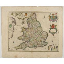
Anglia Regnum.
Janssonius' map of England and Wales was one of the new maps prepared by him in 1636. His map closely copies the similar map issued two years earlier by Willem Blaeu.. Th...
Date: Amsterdam, 1642
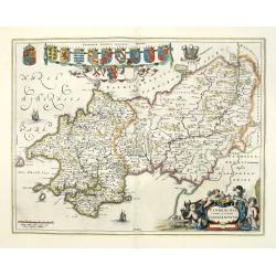
Penbrochia Comitatus et Comitatus Caermaridunum.
Attractive map of the county of Pembroke shire in the UK by J. Blaeu. From a Dutch edition of "Atlas Maior" in beautiful color. With 13 coats of arms, the feath...
Date: Amsterdam, 1648
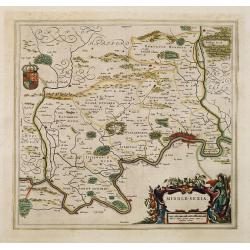
Middle-sexia.
Double-page map of the old Middlesex County, including a marvelous depiction of London on the Thames in the lower right corner. Decorative cartouche and coat of arms. Lat...
Date: Amsterdam, 1662
Selling price: ????
Please login to see price!
Sold in 2024

Pascaert van Engelant Van t'Voorlandt tot aen Blakeney waer in te sien is de mont vande Teemse.
Two charts on one sheet. One decorative sea chart of the southeast coast of England with an inset of the Thames till London, embellished with two title cartouches, a ship...
Date: Amsterdam, 1666

Het Canaal tusschen Engeland en Vranciick.
An eye-catching chart of the Channel.Pieter Goos (ca. 1616-1675) was one of the most important cartographers, engravers, publishers and print sellers of Amsterdam. His wi...
Date: Amsterdam, after 1666

.Paskaarte om Achter Yrlandt om te Zeylen van Hitlant tot. . .
An eye-catching chart of Ireland, including the north of England and Scotland, with the West to the top.Pieter Goos (ca. 1616-1675) was one of the most important cartogra...
Date: Amsterdam, 1673

Carte de la Manche. . .
Decorative chart showing the Chanel, with the coastline of France from La Baie de Douarnenez to Dunkerque, and the coastline of England from Stroble head to Manning Tree....
Date: Amsterdam, 1692
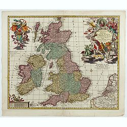
Magnae Britaniae Tabula; Comprehendens Angliae, Scotiae, Ac Hiberniae Regna . . .
Rare Dutch map of the British Isles in very attractive full original color. In this state the wording "Scilly Isles" is added. A decorative title cartouche in t...
Date: Amsterdam, after 1694

Urbium Londini et West-Monasterii nec non Surburbii Southwark Accurata Ichnographia ,., Neuester Grundris der Staedte London und West-Munster, Samt der Vorstadt Southwark ,.,
Detailed plan of London, extending from Grosvenor Square in the west to Mile End to the east, To the right inset views of St, James's Square, and Custom House, elevations...
Date: Nuremberg, 1736

Itinera Varia Auctoris.
From A Natural History of Uncommon Birds, and of some other rare and undescribed Animals, Quadrupeds, Reptiles, fishes, insects, &c.. The map shows Edwards' journeys ...
Date: London, 1746

A view of Westminster bridge. Vue du pont Westminster.
A very decorative and extremely rare collection of river Themes and Westminster Bridge in London, including a six-line description in French and English. Published by Jac...
Date: Paris, ca.1750
Vue de l'Hotel du Lord Maire, qui comprend.. (London)
In the eighteenth and nineteenth centuries there were many popular speciality establishments in Paris, Augsburg and London which produced optical viewing devices and spec...
Date: Augsburg 1750
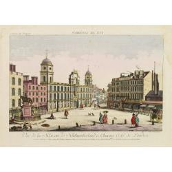
Vue de la Maison de Northumberland a Charing Cross. . .
In the eighteenth and nineteenth centuries there were many popular speciality establishments in Paris, Augsburg and London which produced optical viewing devices and spec...
Date: Augsburg 1750

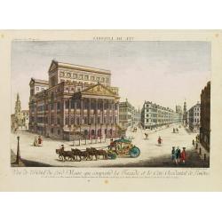
Vue de l Hotel du Lord Maire, qui comprend la Façade, et le Cot' Occidental de Londres.
Shows the famous Lord Mayor's coach driving through London. The Lord Mayor's coach is famous for its role in the Lord Mayor's Show, which is one of the longest-establishe...
Date: Augsburg, 1750

A View of S. James's Palace Pall Mall. - Vues du Palais royal de S.Jacques Pall Mall.
So-called optical print illustrating a perspective view of St James's Palace, Pall Mall. The gatehouse of St James's Palace is on the left.In the eighteenth and nineteent...
Date: Paris, 1753
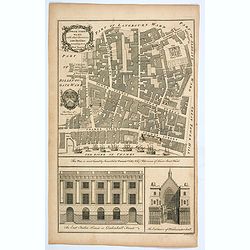
Tower Street Ward with their Divisions into Parishes according to a New Survey.
A fascinating plan of Tower Street Ward, one of the 25 City of London Wards. It lies close to the Tower of London. Much of the ward was lost to Billingsgate Ward in bound...
Date: London, 1757

Vuë du dedans de l'Eglise de St. MARTIN à Londre.
So-called optical print illustrating a perspective view of the central aisle of St. Martin's church, in London.In the eighteenth and nineteenth centuries, many popular sp...
Date: Paris, 1760

26e Vüe d'Optique Representant L'Abbaye de Westminster et de l'Eglise Ste. Marguerite à Londres.
So-called optical print illustrating a perspective view of Westminster Abbey, in London.In the eighteenth and nineteenth centuries, many popular specialty establishments ...
Date: Paris, 1760

39e Vüe d'Optique Representant L'Hotel du Lord Maire de Londre.
So-called optical print illustrating a perspective view of Somerset House on the Strand in London.In the eighteenth and nineteenth centuries, many popular specialty estab...
Date: Paris, 1760

Vue Interieure de la Bourse Royale à Londres.
So-called optical print of the London stock exchange. Daumont was a well-known publisher of optical prints, established in Paris. In the eighteenth and nineteenth centuri...
Date: Paris, 1760
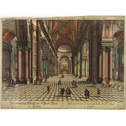
Vue interiere de la Cathedrale de St.Paul a Londres.
So-called optical print, engraved by F.Leizelt. In the eighteenth and nineteenth centuries there were many popular speciality establishments in Paris, Augsburg and London...
Date: Augsburg 1780
Present Britain.
A fully colored map of England and Wales from An Universal Atlas Consisting of a Complete Set of Maps, peculiarly adapted to illustrate and explain ancient and modern geo...
Date: London, 1797

Langley's New Travelling and Commercial Map . . .
A highly desirable, detailed and uncommon map of England and Wales, published by Langley and Belch. The map is flanked by a pair of large and detailed explanation tables,...
Date: London, 1817

London in Miniature With The Surrounding Villages. An Entire New Plan In which the Improvements both present and intended are actually reduced, by permission, from the surveys of the Several Proprietors. . .
Hand-coloured engraved map, dissected and mounted on linen, orange publishers label on one side, extending west to east from Kensington to East India and Greenwich Dock a...
Date: London, 1821
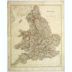
England.
A large and detailed steel-engraved map of England, with each county divided by a different color. Many place names and physical features are shown, illustrating how dens...
Date: London, 1839
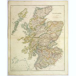
Scotland.
An attractive steel engraved map of Scotland, with each county divided by a different color. Many place names and physical features shown.The Arrowsmith family members we...
Date: London, 1839

Wallis's Guide for Strangers Through London.
Engraved plan with original hand-coloring, with title and alphabetical list of the principal streets below. Published by Edward Wellis 42 Skinner Street.With "An alp...
Date: London, E.Wallis, ca. 1840
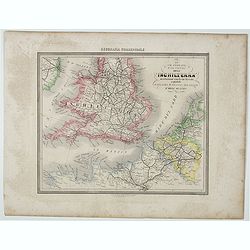
Le Vie Ferrate e Postali dell' Inchilterra . . .
Uncommon map of England and part of France prepared by Francesco Costantino Marmocchi. Above the map "Geografia Commerciale". From "Il Globo Atlante di car...
Date: Genova, Paolo Rivara fu Giacomo, 1858

AFFAIRES D'ORIENT Départ des Grenadiers de la Garde Anglaise, à bord du Steamer transatlantique l'Orenoco. . .
Beautiful lithography of the British steamboat "l'Orenoco" departure from Southampton in May 1854, with soldiers leaving for the Crimean War. After a design Lou...
Date: Paris, Lemercier, c.1860
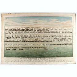
The Royal Naval review at Spithead, June 26th, 1897. In Honour of Her Majesty Queen Victoria's Diamond Jubilee.
A very decorative and large chromolithographed plate showing a line up of international vessels at Spithead, June 26th, 1897 In Honour of her Majesty Queen Victoria'a Dia...
Date: Portsea, ca. 1897
![[West Central London from Booth's Poverty Map of London]](/uploads/cache/40267-250x250.jpg)
[West Central London from Booth's Poverty Map of London]
A map of West Central London, one section (of twenty) of an extended version of the incredibly influential Poverty Map, originally published in Charles Booth's 'Life and ...
Date: London, 1900

The Wonderground Map of London.
A large and pictorially striking 'Wonderland' advertising poster on behalf of the London Underground, published in the late 1920s. The poster was very popular, and ran fo...
Date: London, 1927

(Art déco gouache with winter scene of The Palace of Westminster )
Outstanding "art deco" gouache (unsigned) from the workshop of "Robert Pichon. Ateliers de Dessin et Lithographie – 10, rue Rochechouart – Paris. The ...
Date: Paris, ca. 1930

A map of the British Army with battle honours and militray achievements and Regimental Badges . . .
Shows English County Regiments, Battle Honours and Military Achievements. Bordered by Regimental Badges.A fascinating piece of British history.Read more about Pictorial M...
Date: London, 1952
