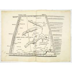
Octava Asie Tabula (The Silk Road Area.)
Woodblock printed large-format map showing Northern India with Central Asia including the Himalayas and China. From the 1513 edition of Waldseemüller's Geographia.In the...
Date: Strasburg, 1513
![[India and China]](/uploads/cache/33875-250x250.jpg)
[India and China]
Wood block printed map and one of earliest printed representation of India and China prepared Martin Waldseemüller. Based on the slightly larger map from 1513 published ...
Date: Vienna, 1525 -1541

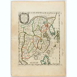
Tabula Superioris Indiae & Tartariae maioris. (Modern Map of China, Japan, etc.)
Important map extending from Tartary in the north, to "Prov. Bocat" (Cambodia) in the south. "Tebet" is shown prominently, as is "Zinpangri"...
Date: Vienne, 1541

Chinae, olim Sinarum regionis. . .
The first printed map of China. It is signed by Ludovico Georgio, whose real name was Luis Jorge de Barbuda. He was a Portuguese Jesuit cartographer and besides that a sp...
Date: Antwerp, 1598
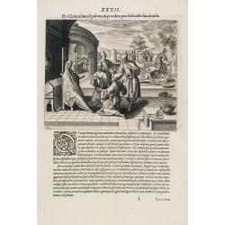
Funeral in China.
A scene of a funeral in China from Linschoten's famous voyages to the East of 1583-92, here published by De Bry the year after they first appeared as a separate book. Fro...
Date: Frankfurt, 1599
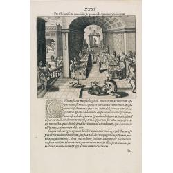
Feast of China.
A scene of a Chinese dinner feast from Linschoten's famous voyages to the East of 1583-92, here published by De Bry the year after they first appeared as a separate book....
Date: Frankfurt, 1599
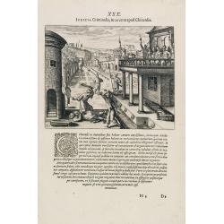
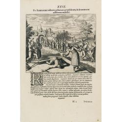
Punishment of a criminal in China.
Punishment of a criminal in China from Linschoten's famous voyages to the East of 1583-92, here published by De Bry the year after they first appeared as a separate book....
Date: Frankfurt, 1599
Punishment of China.
The Chinese way of a punishment from Linschoten's famous voyages to the East of 1583-92 here published by De Bry the year after they first appeared as a separate book. Fr...
Date: Frankfurt, 1599
![[A Chinese vessel ] Naves Chinensibus usitatae velis arundineis & anchoris ligneis.](/uploads/cache/29498-250x250.jpg)
[A Chinese vessel ] Naves Chinensibus usitatae velis arundineis & anchoris ligneis.
Showing a Chinese vessel, print taken from Linschoten's famous voyages to the East of 1583-92, here published by De Bry the year after they first appeared as a separate b...
Date: Frankfurt, 1599
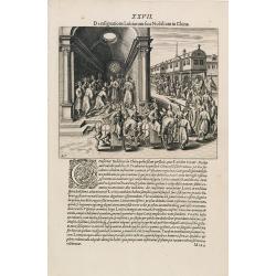
A Parade of Noblemen in China.
This famous and desirable scene from Linschoten's famous voyages to the East of 1583-92 is here published by De Bry the year after they first appeared as a separate book....
Date: Frankfurt, 1599
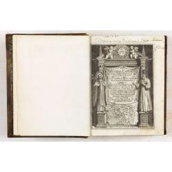
De Christiana expeditione apud Sinas suscepta ab Societate Jesu, ex P. Matthaei Ricci.
Very rare first edition of the most influential Western description of China since the 13th-century account by Marco Polo. Printed in Latin with an engraved title page in...
Date: Augustæ Vind. (Augsburg), C. Mangium, 1615

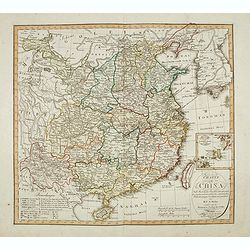
The Kingdome of China.
A most sought-after map of China. Decorative border vignettes including views of the cities of Quinzay and Macao along the top border with the wheeled wind machines and p...
Date: London, G. Humble, 1627

China Veteribus Sinarum Regio.
Based on Jesuit surveys, the map represents the next major revision in the cartography of China after Ortelius' 1584 map. Korea, however, is still an island, and Japan co...
Date: Amsterdam, 1640
Pecheli sive Peking imperii sinarum provincia prima.
The map of the province of Peking from Joan Blaeu's Novus Atlas Sinensis , the first atlas of China with maps by the hand of the Italian Jesuit Martino Martini. A beautif...
Date: Amsterdam, 1640
Royaume de la Chine. . .
Detailed map of China. Engraved by A.Winter. Attractive miniature map, depicting Korea as an island and parts of Japan, i.e. western part of Honshu and Kyushu.
Date: Paris, 1656

Xantung, sinarum imperii provincia quatra.
A map of the northern province ‘Xantung’ of China after the Jesuit Martino Martini. Shows the Great Wall and is centered on the Bohai Sea, and the Shandong and Liaon...
Date: Amsterdam, ca 1660

Pecheli, Xansi, Xantung, Honan, Nanking, In plaga Regni Sinensis. . .
A map of the northern provinces of China after the Jesuit Martino Martini, depicting Hebei (Pecheli), Shanxi (Xansi), Shandong (Xantung), Henan (Honan), and Jiangsu (Nank...
Date: Amsterdam, ca 1660

Fokien Imperii Sinarum Provincia undecima.
The province of Fokien lies opposite Taiwan and south of the region described in the above map. The coast is shown from Wen-zhou in the north to Fu-zhou and as far south ...
Date: Amsterdam, 1660

Xantung, sinarum imperii provincia quatra.
A map of the northern province ‘Xantung’ of China after the Jesuit Martino Martini.Shows the Great Wall and is centered on the Bohai Sea, and the Shandong and Liaonin...
Date: Amsterdam, ca 1660

An embassy from the East-India Company of the United Provinces, to the Grand Tartar Cham, Emperor of China deliver'd by their excellencies, Peter de Goyer and Jacob de Keyzer, at his imperial city of Peking. . .
Very rare first English text edition of this most important and early resource on China and the Chinese. Three parts in one folio by John Macock for the author.Part I: An...
Date: London : Printed by the Author at his house in White-Friers, 1669

La Chine d'Athanase Kirchere de la compagnie de Jesus, illustrée de plusieurs monuments tant sacrés que profanes et de quantité de recherches de la nature. . .
Athanasius Kircher, S.J., (1601 or 1602-1680) was a 17th-century German Jesuit scholar who published around 40 works, most notably in the fields of oriental studies, geol...
Date: Amsterdam, 1670

Il regno della China detto presentente Catay e Magnin. . .
A rare and decorative Italian map of China and Japan, with Japan closely modelled on the indented Cardim outline and Hokkaido, called Yuppi , shown as an Asian peninsula....
Date: Rome, 1682
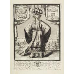
La Reine de la chine.
Very rare and decorative costume plate. In the background : Palais Royal Peking. Beneath the plate a descriptive text about the Queen of China.Bears the address : Se vend...
Date: Paris, ca. 1685

Paradigma XV Provinciarum et CLV Urbium Capitalium Sinensis Imperij Cum Templis quae Cruce X Signatur Et Domiciliis S.I.
First edition of this rare Jesuit map of China, published by Jean Baptiste Nolin in Paris and based on Philippe Couplet's map of 1686. The map shows China's 15 provinces ...
Date: Paris, 1686

Iunan, Queichev, e Quangsi Provincie della Cina. . .
A beautiful map depicting the area of Beijing with decorative title cartouche and scale cartouche. Information about the area at the top of the map.The remarkable Vincenz...
Date: Venice, 1690

Quantung, e Fokien, Provincie della China...
A beautifully engraved decorative map of Southern China extending from Hainan in the West to Formosa in the East and centered on the Pearl River Delta with Macao and the ...
Date: Venice, 1691

Het gezandtschap der Neerlandtsche Oost-Indische Compagnie, aan den grooten Tartarischen Cham, Den tegenwoordigen Keizer van China. . .
Third edition of this beautifully illustrated work on China. The first edition was published in 1665.Jan Nieuhof was a "Dutch traveler and adventurer" (1618-72)...
Date: Amsterdam, W. Waasberge, 1693

Parte orientale della China.. / Parte occidentale della China. (2 sheets)
The map depicts the eastern part of China with Korea -correctly- as a peninsula. Formosa is included as well. Japan is partly visible i.e. the area of Yamaguchi, strait K...
Date: Venice, 1695

Imperii Sinarum nova descriptio.
Schenk and Valk's rare early 18th century issue of Janssonius milestone map of China, Korea and Japan after Martino Martini. Engraved by Johannes van Loon. The overall ba...
Date: Amsterdam, ca. 1720

Habillement de l'Empereur de la Chine & des Dames de son Palais..
This impressive engraving is a wonderful example of Chatelain’s elegant plates.Divided in 3 panels, showing examples of costumes of Chinese ladies and those of the king...
Date: Amsterdam, ca. 1728

Hedendaegsche Historie of tegenwoordige staet van alle volkeren 1 deel. (Volume 1 - China, Japan, Phillippines, Moluccas)
This provides an interesting illustrated description of China, Japan, the Phillippines, Moluccas. Including a map of China, Korea, and Japan, with the Sea between Korea a...
Date: Amsterdam, 1734
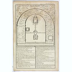
Plan du Tien-tang ou du temple, où l'empereur sacrifie à Chang-ti sous le titre de souverain seigneur de la terre.
Nice example of d'Anville's plan of Tien-tang temple, from "Atlas général de la Chine..."" prepared by Jesuit missionaries and commissioned by Emperor Ka...
Date: Paris, P.G. Le Mercier, 1735
Description geographique, historique, chronologique, politique, et physique de l'empire de la Chine et de la Tartarie chinoise.
First edition of this cornerstone of any collection of books on China, which is also among the rarest and most desirable of important Americana, included in Rare American...
Date: Paris, P. G. Le Mercier, 1735

Description geographique, historique, chronologique, politique, et physique de l'empire de la Chine et de la Tartarie chinoise . . . du Thibet, & de la Coree. . .
Without the separately published atlas. Lacking 2 plates in vol.2 (Obseques at p.149 and Gin seng at p.180), one plate torn without a loss (vol.1, p.230), d4 vol.1 with a...
Date: The Hague, H. Scheurleer, 1736

Carte la plus generale et qui comprend la Chine, la Tartarie chinoise et le Thibet. . .
It has a quite elaborate pictorial cartouche engraved by G. Kondet. It is a very detailed map of China, Tibet, and Korea.In the upper left corner is very good details of ...
Date: The Hague, 1737
![Province de Fo-Kien. [Includes West Coast of Taiwan]](/uploads/cache/43503-250x250.jpg)
Province de Fo-Kien. [Includes West Coast of Taiwan]
An important map of Fujian Province shows the East Coast of China and the West Coast of Taiwan. It shows that for the Manchu Qing, only the western half of Formosa was co...
Date: The Hague, H. Scheurleer, 1737

Nouvel atlas de la Chine, de la Tartarie chinoise, et du Thibet.
First edition of "the principal cartographic authority on China during the 18th century". It was the second major atlas of China produced in Europe following th...
Date: The Hague, H. Scheurleer, 1737

Nuova carta dell' Imperio della Chia e dei Paesi circonvicini. / Nueva carta de l'Impario de la Quina.
The map is of interest for the use of Mar di Corea" and "Mar Setentrionale del Giapone" in the sea between Korea and Japan.Rare early edition of Albrizzi's...
Date: Venice, 1740
![Carte de la coste orientale de la Chine depuis Amoy, jusqu'à Chusan avec une partie de l'Isle Formose [with] Plan du port d'Amoy ou Emouy.](/uploads/cache/33583-250x250.jpg)
Carte de la coste orientale de la Chine depuis Amoy, jusqu'à Chusan avec une partie de l'Isle Formose [with] Plan du port d'Amoy ou Emouy.
Important French chart of the China Sea with the coast of Northern China, including a large depiction of Formosa.Latitude and longitude scales, compass rose and system of...
Date: Paris, Jean-François Robustel, 1745

A view of the town and castle of Macao.
A nice engraving that shows the attack of the English ship "Centurion" on Macau, during which she captured a Portuguese ship that had sailed from Manila. In up...
Date: London, 1746
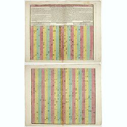
Tabula chronologica historiae Sinicae connexa cum cyclo qui vulgo Kia Tse dictur.
A set of two sheets of colored copper engravings. First published in 1729 in Rome in three sheets. Timeline of China's history with a chronological overview of the dynast...
Date: Augsburg, 1746

L'Empire de la Chine. . .
Detailed map of China, Korea and Taiwan. The large title cartouche is resplendent in the French style with musicians, a dancer, and various accouterments representative o...
Date: Paris, dated 1750
![Kantong [The Dutch Folly Fort off Canton]](/uploads/cache/05714-250x250.jpg)
Kantong [The Dutch Folly Fort off Canton]
Charming 18th water color on paper depicting The Dutch "Folly Fort" off Canton. Probably made by a western artist visiting China.Forts were built in several pla...
Date: Canton?, c.1750

Kancheu.
Charming 18th water color on paper depicting Kancheu. Probably made by a western artist visiting China.
Date: c.1750
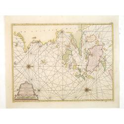
Paskaart van de Eijlanden Cheuxan Lowang en alle deselfs onderhoorige Eylande. . .
A rare and finely engraved and detailed chart of China's Zhejiang Province, including Ningbo, Zhoushan and Mount Putuo (Powto) and the mouth of the Yangtze Delta, just so...
Date: Amsterdam, 1753

A new & accurate map of the Empire of China from the Sieur Robert's Atlas. With improvements.
An excellent early engraving of China and Korea that appeared in Sieur Robert de Vaugondy's Geographical Dictionary (London: 1759). Decorative title cartouche on the uppe...
Date: London, 1759

Vue perspective de la grande Ceremonie du Couronnement de l'Empereur de la Chine.
So-called optical print illustrating the crowning of the Chinese emperor. It shows the throne at the center.Mondhare was a well-known publisher of optical prints, establi...
Date: Paris, 1761

A chart of the China Sea inscribed to Monsr. D'APRES de MANNEVILLETTE .. To A.Dalrymple.
This most important milestone chart is based upon the surveys made from navigational surveys by Alexander Dalrymple (1737-1808]. He was the first hydrographer of the Brit...
Date: Paris, ca 1775
A Chart, on Mercator's Projection, Containing the Track and Soundings of the Lion, the Hindostan and Tenders, from Turon-Bay in Cochin-China. . .
A chart engraved by Baker and published by Nichol, this large chart traces the routes of the Lion, Hindostan, and Tenders with considerable detail. The chart was part of ...
Date: London, 1796
A Plan of the city and harbour of Macao : a colony of the Portugueze, situated at the southern extremity of the Chinese Empire. . .
A large chart of Macao engraved by Benjamin Baker (fl. 1766-1824) and published by George Nicol. The town of Macao is shown in detail, with a 37-point key in English list...
Date: London, 1796

La China e Giapone.
Uncommon map of China, Korea, Japan and Taiwan (I.Formosa), only one town labeled, Tayoan. Very strange shape for Japan.The map is of interest for the use of Mar di Corea...
Date: Italy, ca. 1800

Reis-kaart van het Britsche gezantschap van Hang-choe-foe naar Quang-choe-foe of Kanton in China.
Uncommon map of eastern part of China, showing a journey of the English Embassy from Hangzhou (south of Shanghai) to Guangzhou (Canton). The maps is giving a wealth of in...
Date: Netherlands, c.1800
Charte von China nach Murdochischer Projection entworfen. ... Berichtiget, und gezeichnet von H.F.A. Stieler. . .
Uncommon map of China prepared by H.F.A.Stieler, with parts of Taiwan, Tibet, Mongolia and the Korean peninsula, with a great many place names, a key to (and brief explan...
Date: Weimar, 1804

Map of China.
Showing China, Taiwan and Korea, divided into provinces with the main cities marked. The map is of interest for the use of Sea of Corea, the sea between Korea and Japan, ...
Date: London, 1804
![Morokoshi Meisho Zue [Illustrated Description of Famous Sites of China].](/uploads/cache/34118-250x250.jpg)
Morokoshi Meisho Zue [Illustrated Description of Famous Sites of China].
Published in Osaka, Kawachiya Genhichiro, et al. [8 book sellers], slightly later issue but apparently in Edo period, using all the same woodblocks of original first edit...
Date: Osaka, Edo, slightly later than Bunka 3, year of the tiger - 1806

Charte von China und den angränzenden Ländern und Völkerschaften so wie den letzten Kaiser Tschien-Long. . .
Uncommon map of China on a scale of ca. 1:6,000,000. The map's complete title is “Charte von China und den angränzenden Ländern, und Völkerschaften so wie sie dem le...
Date: Parague, 1812
Selling price: ????
Please login to see price!
Sold in 2023

Chungguk-do
Chungguk-do [Map of China] taken from a Korean printed Ch’onha chido [Atlas of all under Heaven] which is a 19th century version of the traditional Korean atlas produce...
Date: Korea, ca. 1820
![[8 sheets - Partie du THIBET]](/uploads/cache/36629-250x250.jpg)
[8 sheets - Partie du THIBET]
A set of 8 maps covering Tibet region and the Himalayas.From his famous Atlas Universel . This atlas was one of the most remarkable world atlases ever produced, anticipat...
Date: Brussels, 1825-1827

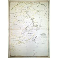
Partie de la Chine N°86. (Covers Guizhou and parts of Yunnan, Guangxi, Hunan, Hubei and Sichuan.)
Covers Guizhou and parts of Yunnan, Guangxi, Hunan, Hubei and Sichuan.From his famous Atlas Universel . This atlas was one of the most remarkable world atlases ever produ...
Date: Brussels, 1825-1827

Partie de la Chine N°87. (Covers Jiangxi, Fujian and parts of Zhejiang, Guangdong, Hunan and Hubei.)
Covers Jiangxi, Fujian and parts of Zhejiang, Guangdong, Hunan and Hubei.From his famous Atlas Universel . This atlas was one of the most remarkable world atlases ever pr...
Date: Brussels, 1825-1827

Partie de la Chine. N°.74 (Including South Korea)
Covering the Mouth of the Yangtze area in Jiangsu and Zhejiang, and southwestern Korea with the island of Quelpart (Jeju-do). Shows explorers' routes, including La Perou...
Date: Brussels, 1825-1827
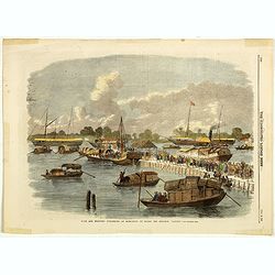
Sick and wounded embarking at Hong-Kong on Board the Steamer.
Large view of the harbour with numerous ships and people. From the Illustrated London News, October 23, 1858.
Date: London, October 1858

A fan combining views of Hong Kong (right), Canton (center), and Macau.
The fan shows nice images of Macau, Hong Kong and Canton on onside and on verso a garden with 45 characters welcoming a rider on his white horse. Their clothes are height...
Date: China, ca. 1850-1860

Plan de la rade de Macao (chine) Levé d'après les ordres mr. Rocquemaurel.
Very detailed chart of Macao and several of the surrounding Islands, and features numerous depth soundings throughout. Prepared by captain, Gaston de Rocquemaurel. Logo o...
Date: Paris, c.1856 / 1863
![Carte du Tche-Kiang. [ Zhejiang province ]](/uploads/cache/30921-250x250.jpg)
Carte du Tche-Kiang. [ Zhejiang province ]
Map of Tche Kiang, prepared by Bishop Edmond-François Guierry, C.M. (Vicar Apostolic of Zhejiang, China) after sources supplied by missionaries. Published in "Les M...
Date: Paris, 1874

Carte du Kouy-Tchéou.
Detailed map of Guizhou Province prepared by Mgr. Faurie and other sources supplied by missionaries. Published in "Les Missions Catholique". Engraved by P. Méa...
Date: Lyon, c.1874
(Set of 4 maps) Itinéraire de Pékin à Sartchy
Set of 4 geological maps from the "Nouvelle Archives du Museum" printed by Becquet.1) Route de Pekin a Suen-Hoa-Fou2) Route de Thae-Seu-Tchouang aux tentes mong...
Date: Paris, ca. 1880
![Hong Kong. [Queen's Road]](/uploads/cache/24362-250x250.jpg)
Hong Kong. [Queen's Road]
Finely executed watercolor made by Henri Dieth of a charming atmospheric street scene at Queen's Road in Hong Kong. The watercolor is made after Eduard Hildebrandt (1818-...
Date: Germany, 1882
![Hongkong Piratenstrasse. [Pirate Street]](/uploads/cache/24363-250x250.jpg)
Hongkong Piratenstrasse. [Pirate Street]
Finely executed watercolor made by Henri Dieth of a charming street scene at "Pirate Street" in Hong Kong. The watercolor is made after Eduard Hildebrandt (1818...
Date: Germany, 1882

Runde Strasse in Peking.
Finely executed watercolor made by Henri Dieth of a charming street scene in Peking. The watercolor is made after Eduard Hildebrandt (1818-1869). Hildebrandt, was born in...
Date: Germany, 1882
![Nankin [Nanjing, Jiangsu]](/uploads/cache/30031-250x250.jpg)
Nankin [Nanjing, Jiangsu]
Very detailed (1:1.000.000) map showing the area north of Nanjing, Jiangsu. The French Service géographique des armées was founded in 1887 and provided the French milit...
Date: Paris, 1900

COLLECTION OF HONG KONG MAPS, BOOKS & FLYERS. Including CHINA - HONGKONG surveyed by Captn. Sir Edward Belcher, in H.M.S. Sulphur 1841. Corrected to 1901.
A collection of 30 maps, prints, and publications relating to Hong Kong. Including : - BELCHER, E. Sir, An updated version of this most important nautical chart of Hong K...
Date: London, 1841 - 1901
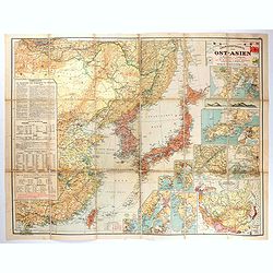
Übersichtskarte von Ost-Asien im Maßstabe 1: 5.000.000 mit 14 Beikarten in großen Maßstäben . . .
A large, uncommon map of East Asia prepared by Karl Peucker, and published by Ataria & Co. Striking and heavily annotated with information on China, Korea, Japan, and...
Date: Vienna, Artaria, 1904

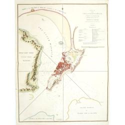
CANTON Kong-Teheou.
Very detailed (1:1.000.000) map centered on Macao and Victoria Island, showing soundings, English, Australian, Danish telegraph lines reaching Hong Kong and extended to M...
Date: Paris, 1898 updated for june 1904

Designs for Porcelain ware with Chinese design.
In left hand side "Planche d'aquarelle N° 05501". Original design created by the Sevres artist Gabriel Fourmaintraux ( 1886 - ) at about 1910 to serve as guide...
Date: Desvres, 1905 - 1925

Designs for porcelain vases with Chinese motif.
Hand colored design of 13 vases with attractive patterns of a classic Chinese motif. In right "Planche d'aquarelle N° 04004" and the numbers 7.404, 2.074, 8.93...
Date: Desvres, 1905 - 1925

Designs for two porcelain bowls with Chinese design.
With numbers 4.601, 4.818. In top "Planche N° d'ordre : 03004.Original design created by the Sevres artist Gabriel Fourmaintraux ( 1886 - ) at about 1910 to serve a...
Date: Desvres, 1905 - 1925

Designs for porcelain plate with Chinese design.
In right hand side "Planche d'aquarelle N° 06502". And the numbers 11.153, 11.154, 11.155. Original design created by the Sevres artist Gabriel Fourmaintraux (...
Date: Desvres, 1905 - 1925

Designs for porcelain vase with Chinese motif.
With attractive pattern of a classic Chinese motif. In top "Planche d'aquarelle N° 04510" and the numbers 2,198. Original design created by the Sevres artist G...
Date: Desvres, 1905 - 1925

A Map and History of Peiping; formerly known as Peking; capital of provinces, princedoms and kingdoms since 1121 B.C. . .
The uncommon second edition of this very decorative and informative pictorial map of Beijing and surrounding areas whimsically illustrates the Forbidden City, essential e...
Date: The Peiyang Press, Ltd. Tientsin-Peiping, 1936
