Browse Listings
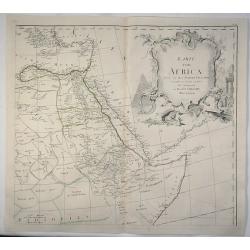
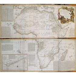
Karte von Africa.
A large copper-engraved wall map of Africa by H. Benedicti after R. de Vaugondy's map of Africa, published by F. A. Schraembl in 1787. This is only the top right sheet of...
Date: Paris, 1787
Selling price: ????
Please login to see price!
Sold in 2020
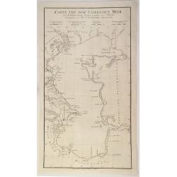
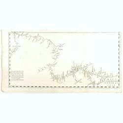
Karte Von Dem Caspischen Meer.
A simple chart of the Caspian Sea showing the harbours of Astrakan and Baku. Engraved by Johann Anton Guldenstadt od Riga, and published by Schraembl in 1787, and was in...
Date: Vienna, 1787
Selling price: ????
Please login to see price!
Sold in 2020
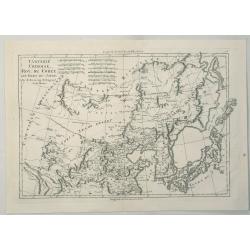
Tartarie Chinoise, Roy, Coree et Isles du Japon.
A detailed map of the region, including Japan, Korea, Manchuria and the Gobi Desert. Highly detailed. From Bonne's 'Atlas Supplement', published in 1787.Rigobert Bonne (1...
Date: Paris, 1787
Selling price: ????
Please login to see price!
Sold in 2023
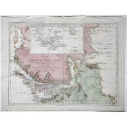
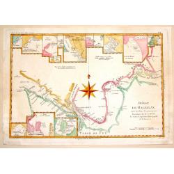
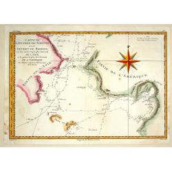
Karte der Magellanischen Strasse.
Full title at center of the map: 'Karte der Magellanischen Strasse von Herrn Don Juan de la Cruz Canoy Olmedillo. Und nach den Beobachtungen der Herrn Byron, Wallis, Cart...
Date: Wien, 1787
Selling price: ????
Please login to see price!
Sold in 2021
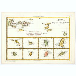
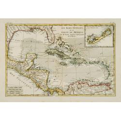
Cartes de Supplement pour les Isles Antilles.
Rigobert Bonne's map of the Virgin Islands and the Antilles Islands (Leeward) in the Caribbean, published in France towards the end of the eighteenth century. Below the m...
Date: Paris, 1787
Selling price: ????
Please login to see price!
Sold in 2020
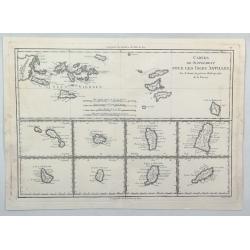
Cartes de supplément pour les Isles Antilles.
An interesting map of the Antilles Islands including: Isles Vierges / Isle St Christophe / Isle Antigoa / Isle de la Dominique / Isle Ste Lucie / Isle de la Barbade / Isl...
Date: Paris, 1787
Selling price: ????
Please login to see price!
Sold in 2023
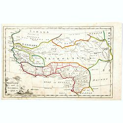
Negroland and Guinea. 1787
Negroland, or Nigritia, is an archaic and outdated term in European mapping, describing the inland and poorly explored region in West Africa as an area populated with neg...
Date: London, 1787
Selling price: ????
Please login to see price!
Sold in 2020
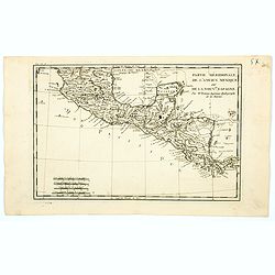
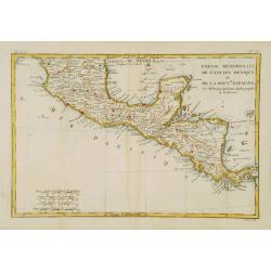
Partie Méridionale, de l'Ancien Méxique ou de la Nouvelle Espagne.
A copper engraved map of southern Mexico and all of Central America. Fine detail including shoals and navigational hazards along the coasts. Four sets of mileage scales g...
Date: Paris, 1787
Selling price: ????
Please login to see price!
Sold in 2020
![L' Ancien et le nouveau Mexique, avec la Floride et la basse Louisiane.. [Texas,California]](/uploads/cache/84796-250x250.jpg)
L' Ancien et le nouveau Mexique, avec la Floride et la basse Louisiane.. [Texas,California]
Fine map on 2 joined sheets, of the southern United States [Florida, Louisiana, Texas, New Mexico and California , further on Mexico, the Central American States, and the...
Date: Paris 1787
Selling price: ????
Please login to see price!
Sold in 2021
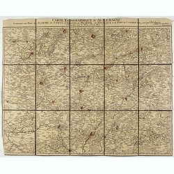
Carte Topographque D'Allemagne / Contenant une partie de Flandre, du Comté d'Artois, de Picardie, du Haynaut et le Pais de Cambresis.
Folding map of Northern France with part of Flanders, the County of Artois, Picardy, the Haynaut and Cambray, published by the German Military cartographer Johann Wilhelm...
Date: Frankfurt, 1787
Selling price: ????
Please login to see price!
Sold in 2021
![[Virgin Islands] Cartes De Supplement Pour Les Isles Antilles.](/uploads/cache/85495-250x250.jpg)
[Virgin Islands] Cartes De Supplement Pour Les Isles Antilles.
An excellent map of the Virgin Islands from Puerto Rico to Barbuda, centered on the American and British V.I., extending from Crab Island, St. Thomas and St. Croix to Sab...
Date: Paris, 1787
Selling price: ????
Please login to see price!
Sold in 2022
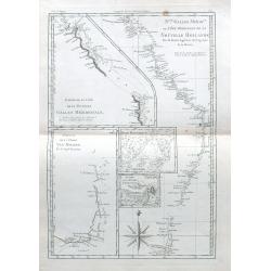
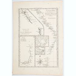
Nlle Galles Merid.le ou Côte Orientale de la Nouvelle Hollande. . .
R. Bonne's interesting sheet shows five charts of Captain Cook's and Tobias Furneaux discoveries on one sheet: Australias east coast in New South Wales, an inset with a p...
Date: Paris, ca 1787
Selling price: ????
Please login to see price!
Sold in 2021
DES POSSESSIONS FRANCOIS AUJOURD'HUI SOUS LA DOMINATION ANGLOIFES.
An interesting, decorative map from Labrador and the Hudson Bay area in Canada to the Gulf of Mexico. Inland as far as the Lake of the Woods and the Great Plains. French ...
Date: Paris, 1787
Selling price: ????
Please login to see price!
Sold in 2022
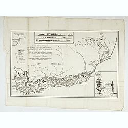
Carte géographique du Cap de Bonne Esperance contenant les noms et positions . . .
Folding map of Cape of Good Hope, from " Voyage au Cap de Bonne-Esperance, et autour du Monde avec le Capitaine Cook, et principalement dans les pays des Hottentots ...
Date: Paris, 1787
Selling price: ????
Please login to see price!
Sold in 2022
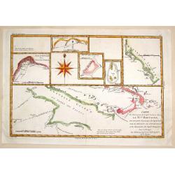
Nouvelle Galles Meridionale ou Cote Orientale de la Nouvelle Hollannde / Baie Botanique / Esquisse de la Terre Van-Diemen…
Rigobert Bonne's map of parts of southern and eastern Australia, based on earlier observations by Cook and Furneaux, published in Paris during the last quarter of the eig...
Date: Paris, 1787
Selling price: ????
Please login to see price!
Sold in 2023
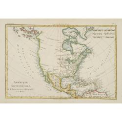
Amerique Septentrionale.
Fine map of Northern and Central America, showing even part of the South American continent, prepared by R.Bonne and included in his Atlas Encyclopédique.. Rigobert Bonn...
Date: Paris 1787
Selling price: ????
Please login to see price!
Sold
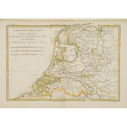
Carte de la Hollande prise en général..
Fine map of the Netherlands, prepared by R.Bonne and included in his Atlas Encyclopédique.. Rigobert Bonne (1727-1795) was engineer, mathematician and cartographer, acti...
Date: Paris 1787
Selling price: ????
Please login to see price!
Sold
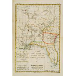
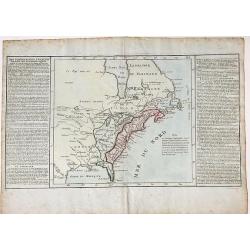
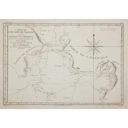
Carte de la Louisiane, et de la Floride.
Handsome map of the American Southeast and the Mississippi River Valley. The map extends from Charleston, South Carolina west to include New Orleans and north well into I...
Date: Paris 1787
Selling price: ????
Please login to see price!
Sold
Les Isles Antilles, et le Golfe du Méxique.
An attractive map of the Caribbean with good detail of Central America. Includes the Gulf Coast and Florida with St. Augustine, Pensacola and New Orleans named. A large i...
Date: Paris 1787
Selling price: ????
Please login to see price!
Sold
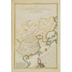
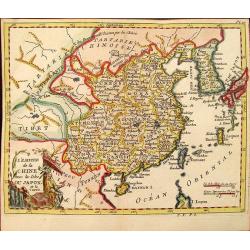
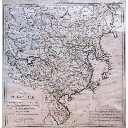
Carte de l'Empire de la Chine, de la Tartarie Chinoise, et du..
A fine map of China, Korea, Japan and Taiwan, prepared by R.Bonne and included in his Atlas Encyclopédique.. Rigobert Bonne (1727-1795) was engineer, mathematician and c...
Date: Paris 1787
Selling price: ????
Please login to see price!
Sold
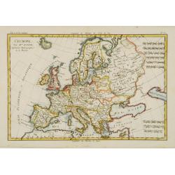
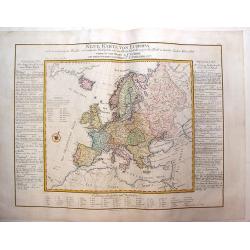
L'Europe.
Fine map of Europe. Elegant hand coloring, prepared by R.Bonne and included in his Atlas Ecyclopédique..Rigobert Bonne (1727-1795) was engineer, mathematician and cartog...
Date: Paris 1787
Selling price: ????
Please login to see price!
Sold
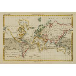
Planisphere suivant la Projection de Mercator.
World map in Mercator projection.Rigobert Bonne (1727-1795), a prolific French cartographer, flourished between about 1760 and 1778, working in the French Hydrographical ...
Date: Paris 1787
Selling price: ????
Please login to see price!
Sold
Partie Méridionale, de l'Ancien Méxique ou de la Nouv.le Espagne.
Copper engraved map of southern Mexico and all of Central America. Fine detail including shoals and navigational hazards along the coasts. Prepared by R.Bonne and include...
Date: Paris 1787
Selling price: ????
Please login to see price!
Sold
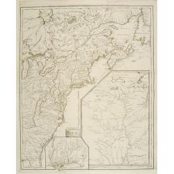
Carte de la Partie nord des Etats Unies de L'Amerique Sept..
Fine map of the east coast of America, including the Lakes Erie and Ontario, prepared by R.Bonne and included in his Atlas Encyclopédique.. Rigobert Bonne (1727-1795) wa...
Date: Paris 1787
Selling price: ????
Please login to see price!
Sold
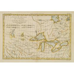
Partie Occidentale du Canada, contenant les cinq Grands Lacs?
Nice example of this map of the Great Lakes depicting frontier forts, missions, and fur trade routes. It covers the region from James Bay to just below Ft. Duquesne and f...
Date: Paris 1787
Selling price: ????
Please login to see price!
Sold
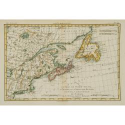
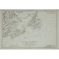
L'Isle de Terre-Neuve, l'Acadie, ou la Nouvelle Ecosse..
Fine map of the northwestern part of Canada, prepared by R.Bonne and included in his Atlas Encyclopédique.. Rigobert Bonne (1727-1795) was engineer, mathematician and ca...
Date: Paris 1787
Selling price: ????
Please login to see price!
Sold
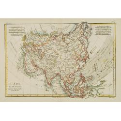
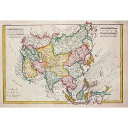
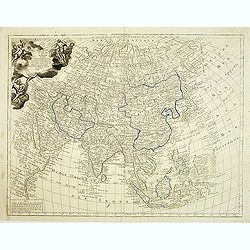
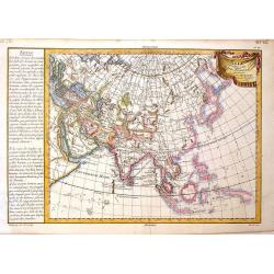
L'Asie.
Fine map of Asia, prepared by R.Bonne and included in his Atlas Encyclopédique.. Rigobert Bonne (1727-1795) was engineer, mathematician and cartographer, active in Paris...
Date: Paris 1787
Selling price: ????
Please login to see price!
Sold
Carte d'une partie de L'Amerique septentrionale..
The map was first published with a title Canada et Louisiane par le Sr. Le Rouge.. : during the Revolutionary War, Le Rouge reworked the plate and re-titled it Theatre de...
Date: Paris 1787
Selling price: ????
Please login to see price!
Sold
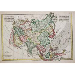
L?Asie.
Rigobert Bonne (1727-1795), French cartographer. His maps are found in a.o. Atlas Moderne (1762), Raynal's Histoire Philos. du Commerce des Indes (1774) and Atlas Encyclo...
Date: Paris, 1787
Selling price: ????
Please login to see price!
Sold
L\'Empire de la Chine avec les Isles du Japon et la Coree.
Attractive map of China and neighbouring countries from Atlas ou Collection de Cartes Geographiques pour l'Intelligence du Voyageur Francois.
Date: Paris, 1787
Selling price: ????
Please login to see price!
Sold in 2012
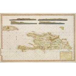
Carte reduite de L'Isle de Saint Domingue.
Very detailed chart made for the official French hydrographical office "Depot générale de la Marine". In top 4 coastal profiles.
Date: Paris, 1787
Selling price: ????
Please login to see price!
Sold

Frontispice de l'Enceclopedie.
Frontispice of Rigobert Bonne's 'Atlas Enceclopédie.
Date: Paris, 1787
Selling price: ????
Please login to see price!
Sold

Atlas encyclopédique..
The atlas was published separately until his complete set of Encyclopédie methodique appeared. 29 Maps relating to America. 19 Historical maps: 6 World maps, continent m...
Date: Paris 1787
Selling price: ????
Please login to see price!
Sold
Atlas du voyageur françois..
Rare atlas volume containing maps of all parts of the world: World map interesting for its depiction of Mer de L'Ouest or Sea of the West a great sea, easily the size of ...
Date: Paris 1787
Selling price: ????
Please login to see price!
Sold
L.Asie.
Rigobert Bonne (1727-1795), French cartographer. His maps are found in a.o. Atlas Moderne (1762), Raynal's Histoire Philos. du Commerce des Indes (1774) and Atlas Encyclo...
Date: Paris, 1787
Selling price: ????
Please login to see price!
Sold in 2019
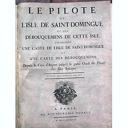
Le Pilote de L'Isle de Saint-Domingue Et Des Debouquemens De Cette Isle, Comprenant Une Carte De L'Isle De Saint-Domingue Et Une Carte Des Debouquemens, Depuis la Caye d'Argent ...
Le Pilote de L'Isle de Saint-Domingue Et Des Debouquemens De Cette Isle, Comprenant Une Carte De L'Isle De Saint-Domingue Et Une Carte Des Debouquemens, Depuis la Caye d'...
Date: Paris, Imprimerie Royale, 1787
Selling price: ????
Please login to see price!
Sold
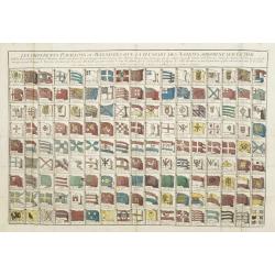
Les differents pavillons ou bannieres que la pluspart des nations arborent sur mer.
Uncommon print showing 152 flags and banners of the sea-faring nations and town states of the world, including the Dutch trading companies of V.O.C., W.I.C.
Date: Paris, 1787
Selling price: ????
Please login to see price!
Sold in 2012
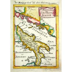
P.tie Meridionale de L' Ancien Italie.
Alain Manneson Mallet (1603-1706) published in 1683 his ' Description de l' Univers' in 5 volumes. In 1686 a German edition appeared.The southern part of classical Italy.
Date: Paris, 1787
Selling price: ????
Please login to see price!
Sold
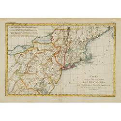
Carte Generale des Etats de Virginie, Maryland, Delaware, Pensilvanie, Nouveau-Jersey, New-York, Connecticut et Isle de Rhodes. Ainsi que des Lacs Erie, Ontario, et Champlain. D'Apres la Carte Ameriquaine de Louis Evans
Nice french map of the eastern part of the USA with the great lakes.
Date: Paris, 1787
Selling price: ????
Please login to see price!
Sold in 2013
AFRICA, WITH ALL ITS STATES, KINGDOMS, REPUBLICS, REGIONS, ISLANDS &c. IMPROVED and ENLARGED from D\'ANVILLE\'s MAP: to which have been Added A PARTICULAR CHART OF THE GOLD COAST, wherein are D
A fascinating, late 18th century wall map of Africa based on the large format map by Jean Baptiste d’Anville, one of France's greatest cartographers. D'Anville was the ...
Date: London, 1787
Selling price: ????
Please login to see price!
Sold in 2013
Isle et Banc de Terre-Neuve, Isle Royale et Isle St. Jean, ...
Detailed map of the region from Newfoundland to the Saint Lawrence and Nova Scotia, from Bonne's Atlas Supplement.
Date: Paris, 1787
Selling price: ????
Please login to see price!
Sold in 2011
Carte de L'Entrée de Norton et du Détroit de Bhering, ...
The Bering Straits and Norton Sound, Alaska, showing the two attempts of Captain Cook's ship to penetrate the Straits on his third & final, fatal, voyage in 1778-79.
Date: Paris, 1787
Selling price: ????
Please login to see price!
Sold in 2011
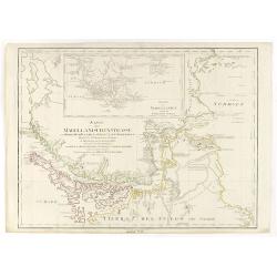
Karte der Magellanischen-Strasse. . .
Very detailed map of Strait of Magellan, with in top inset map of Southern tip of South America with the Falklands. Incorporating the discoveries of Herrn, Byron, Wallis,...
Date: Vienna, 1787
Selling price: ????
Please login to see price!
Sold in 2017
Carte de la Louisiane, et de la Floride.
Handsome map of the American Southeast and the Mississippi River Valley. The map extends from Charleston, South Carolina west to include New Orleans and north well into I...
Date: Paris, 1787
Selling price: ????
Please login to see price!
Sold
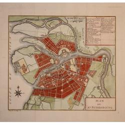
Plan de St. Petersbourg.
Nice town-plan of st. Petersburg.
Date: Paris, 1787
Selling price: ????
Please login to see price!
Sold in 2009
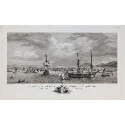
Le Port-au-Prince dans l'Isle de St. Domingue.
Drawn by Nicolas Ozanne and engraved by Jeanne F. Ozanne. Published by Le Gouaz.
Date: Paris, 1787
Selling price: ????
Please login to see price!
Sold in 2010
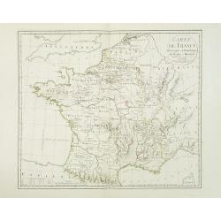
Carte de France historique et chronologique du regne de Henri IV. . .
Map of France during the regime of Henri IV. With a color key in lower left. Prepared by J.A. Dezauche, who was a publisher, map dealer and continued the publications of ...
Date: Paris, 1787
Selling price: ????
Please login to see price!
Sold
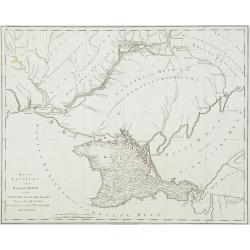
Karte TAURIENS oder der HALBINSEL KRIM und der WESTLICHEN NOGAYISCHEN TATAREI. . .
Map of the region north east of the Black sea, prepared by I.F.Schmid. Scale 1 : 900.000. Map 92 from this uncompleted Atlas by F.A.Schramble. With mileage in German (geo...
Date: Vienna, 1787
Selling price: ????
Please login to see price!
Sold in 2010
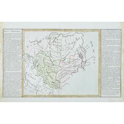
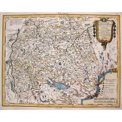
De la Tartarie
Map including the different regions of Tartary. Map centered on the Baikal Lake and the Karzana Lake. In the right and left margins, there are a long explication text. Je...
Date: Paris, 1787
Selling price: ????
Please login to see price!
Sold in 2010
Carte de la Chine.
Uncommon French map of China and adjacent tributary states.
Date: Paris, 1787
Selling price: ????
Please login to see price!
Sold
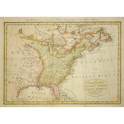
A correct map of the United States of North America..
Fine and uncommon map of the United States according to the treaty of 1784. Engraved for BANKE'S New System of Geography, Published by the Kings Royal Licence.Thomas Bowe...
Date: London, 1787
Selling price: ????
Please login to see price!
Sold in 2011
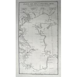
Karte Von Dem Caspischen Meer...
Excellent large-scale chart of the Caspian Sea, showing the harbors of Baku and Astrakan. Further with many towns, bays, small islands and peninsulas. After Johann Anto...
Date: Vienna, 1787
Selling price: ????
Please login to see price!
Sold in 2011
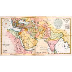
Carte d'Asie, divisée en ses principaux etats : assujettie aux observations astronomiques.
General uncommon map describing Asia with fine cartouche title at upper left.The map is of interest for the use of East Sea, the sea between Korea and Japan, here called ...
Date: Paris, 1787
Selling price: ????
Please login to see price!
Sold in 2012

Plan de St. Petersbourg
A folding map of Saint Petersburg, from Voyage en Pologne, Russie, Suède, Danemark, &c. published by Barde, Manget & Cie.
Date: Geneva, 1787
Selling price: ????
Please login to see price!
Sold in 2012
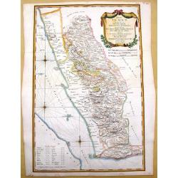
Terrae Yemen Imperii Imami Principatus Kaukeban.
Important detailed copper engraved map of Yemen with details of South-West Arabia, prepared by C. Niebuhr and was published in "Atlas universel pour l'étude de la g...
Date: Paris, Nyon, 1787
Selling price: ????
Please login to see price!
Sold in 2013
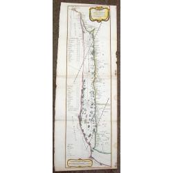
Mare Rubrum Sinus Arabicus Ad Observationes Maximam Partem ab Auctore Annis MDCCLXII et MDCCLXIII.
Important detailed copper engraved map of Arabian Gulf with details of The Red Sea, The Gulf of Arabia and Yemen prepared by C. Niebuhr and was published in "Atlas u...
Date: Paris, Nyon, 1787
Selling price: ????
Please login to see price!
Sold in 2013
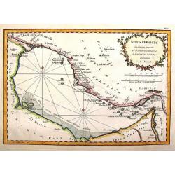
Sinus Persicus Maximam Partem ad Observationes Proprias a MDXXLXV.
Important detailed copper engraved map of the Persian Gulf with details of Persia and Arabia prepared by C. Niebuhr and was published in "Atlas universel pour l'ét...
Date: Paris, Nyon, 1787
Selling price: ????
Please login to see price!
Sold in 2013
Chorographie du Cercle de Souabe d\'apres Vischer, Homan & Hubner.
Map of south-east Germany with two fancy floral Renaissance cartouches. It was published in "Atlas Universal" in 1787. The engraver was Moithey. Étienne Andr...
Date: Paris, 1787
Selling price: ????
Please login to see price!
Sold in 2013
Neue Karte Von Europa
One of the first economic thematic maps of Europe containing a variety of symbols to show the cost of 56 commodities. Other symbols are of cities, ports, and natural and ...
Date: Vienna, 1787
Selling price: ????
Please login to see price!
Sold in 2013
Asia Veteribus Nota, L'Asie Ancienne
Intersting map of Asia with "Notes" to the left. Ribboned title cartouche. Engraved by Herault. Etienne André Philippe de Pretot (1708-1787) a royal censor, g...
Date: Paris, 1787
Selling price: ????
Please login to see price!
Sold in 2013
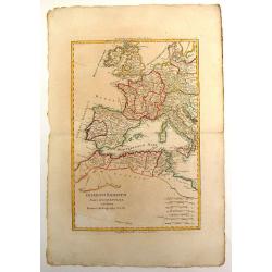
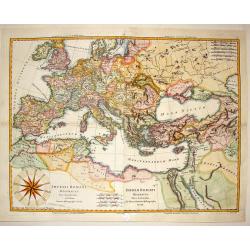
Imperium Romanum Pars Occidentalis.
Interesting map of the Roman Empire published in "Atlas Encyclopedique" and includes Britain, France, Germany, Spain, Italy & part of North Africa. Rigober...
Date: Paris, 1787
Selling price: ????
Please login to see price!
Sold in 2013
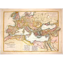
Imperium Romanum pars Occidentalis & pars Orientalis.
Interesting European map of the Eastern and Western parts of the Roman Empire. Two maps (East & West, that were meant to be make up the total)were professionally join...
Date: Paris, 1787
Selling price: ????
Please login to see price!
Sold in 2016
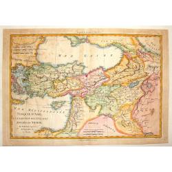
Turquie D'Asie a L'Exception de Enclaves Situees en Arabie.
Detailed, hand-colored, engraved map showing Turkey and parts of the Middle East and Near East. BONNE, RIGOBERT (1729-1795) Bonne was “Royal Hydrographer” and his pr...
Date: Paris, 1787
Selling price: ????
Please login to see price!
Sold in 2015
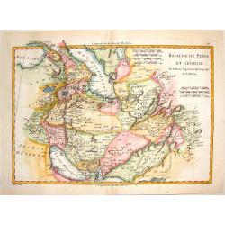
Royaume de Perse et Georgie.
Engraved map of Persia and Russian Georgia from "Atlas Encyclopedique". Spans the area between the Black Sea and the Persian Gulf. BONNE, RIGOBERT (1729-1795...
Date: Paris, 1787
Selling price: ????
Please login to see price!
Sold in 2015
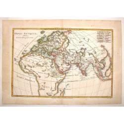
Orbis Antiquus.
A detailed map of the Eastern Hemisphere featuring Africa, Europe and Asia. Published in "Atlas Encylopedique" and engraved by Gaspar Andre. BONNE, RIGOBERT (...
Date: Paris, 1787
Selling price: ????
Please login to see price!
Sold in 2015
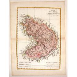
Duche de Silesie et Marquisat de Moravie.
A striking map of the duchy of Silesia and Moravia (currently part of Poland) from the "Atlas Moderne". Engraved by Gaspar Andre.Rigobert Bonne (1729-1795) was ...
Date: Paris, 1787
Selling price: ????
Please login to see price!
Sold in 2015
Imperii Romani Distracta pars Occidentalis & Orientalis.
Attractive hand colored map of the Mediterranean part of the Roman Empire. Issued as two maps (east & west), they have been joined resulting in an unusually large Bon...
Date: Paris, 1787
Selling price: ????
Please login to see price!
Sold in 2014
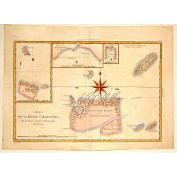
Isles de la Reine Charlotte.
A detailed chart of the Santa Cruz islands, to the north of the New Hebrides, including an inset chart of Carteret and Gower Islands, Baye de L'Hirondelle and Havre de By...
Date: Paris, 1787
Selling price: ????
Please login to see price!
Sold in 2015
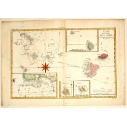
Carte des Isles des Amis.
Finely engraved chart depicts the Friedly Islands including the Kingdom of Tonga. The islands were discovered by Capatain Cook and his passage aboard the Resolution is ma...
Date: Paris, 1787
Selling price: ????
Please login to see price!
Sold in 2015
Detroit de Magellan.
A detailed engraved chart of the Straits of Magellan (between South America and Terra del Fuego), showing the best route through the dangerous straits. With 16 separate i...
Date: Paris, 1787
Selling price: ????
Please login to see price!
Sold in 2014
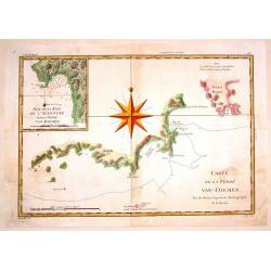
Carte de la Terre Van-Diemen.
Fine, engraved map of part of Tasmania focusing on the coastline surrounding Adventure Bay. Based on Captain James Cook's surveys. Engraved by Andre.Rigobert Bonne (1729-...
Date: Paris, 1787
Selling price: ????
Please login to see price!
Sold in 2015
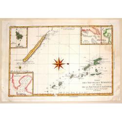
Isles des Nouvelles Hebrides et Celle de la Nouvelle Caledonie.
Fine, engraved map of New Caledonia and Vanuatu, showing the track of Captain James Cook's second voyage. Engraved and signed by Andre. Rigobert Bonne (1729-1795) was “...
Date: Paris, 1787
Selling price: ????
Please login to see price!
Sold in 2015
Carte des Decouvertes du Capitane Carteret dans Nouvelle Bretagne.
Fine map of the New Bretagne Islands off the coast of New Guinea with six additionla inserts. Large prominent compass rose and engraved by Andre. BONNE, RIGOBERT (1729-17...
Date: Paris, 1787
Selling price: ????
Please login to see price!
Sold in 2015
Carte de L'Entre de norton et du Detroit de Bhering.
Fine detailed map of the Behring Strait, the passage between Russia and Alaska. Includes the track of the voyage of Captain James Cook. Engraved and signed in engraving b...
Date: Paris, 1787
Selling price: ????
Please login to see price!
Sold in 2015

(3 Engravings) Edward IV, Henry VI & Edward V.
Three hand-colored, copper engravings of three kings of England that reigned during the 1400's. Each has a wonderful printed frame and a royal coat of arms. They are from...
Date: London, 1787
Selling price: ????
Please login to see price!
Sold in 2016
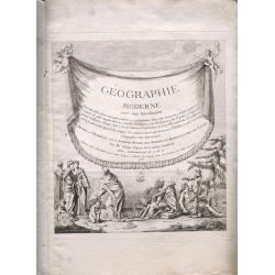
(Title page) Geographie Moderne Avec Une Introduction
Title Page plus additional page of description.
Date: Paris, 1767-1787
Selling price: ????
Please login to see price!
Sold in 2015
Imperia Antiqua.
Three maps that were joined together as planned and depict the eastern part of the Mediterranean, the Near East and the Indian subcontinent. They came from "Atlas En...
Date: Paris, 1787
Selling price: ????
Please login to see price!
Sold in 2014
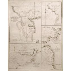
Plan de la Baye de l'Acul; Baye de Dame-Marie; Le Port François; Plan du Môle St. Nicolas; Baye des Irois
Five sea-charts on one large sheet. Engraved by Dela Haye for the Depot de la Marine. Each section shows depth soundings, anchoring places, and coastal information. A ra...
Date: Paris, 1787
Selling price: ????
Please login to see price!
Sold in 2014
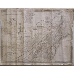
Karte ploskaja ot' goroda Jakucka do Ochockago porta po rekam' Leny Aldana Maji Jodomy i Urakom' do Penzinskavo morja
A detailed map of the Urak River near Okhotsk, eastern Siberia from an unidentified source. The title of the map also in French " Carte dressée et levée en allant ...
Date: Paris, Nyon, Philippe de Prétot, 1787
Selling price: ????
Please login to see price!
Sold in 2014
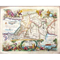
Beschryvinge Van Den Oorsrong de Volkeren, Uit de Drie Sonen van Noah na den Sondvloed.
Striking hand-colored Dutch Bible map covering the region from the Mediterranean through to the Persian Gulf. the map depicts Abraham's route from Ur, Noah's arc, the wan...
Date: Amsterdam, 1787
Selling price: ????
Please login to see price!
Sold in 2015