Subscribe to be notified if similar examples become available.
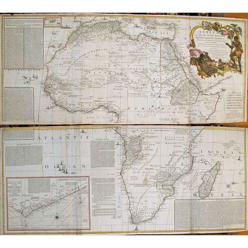
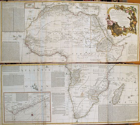
AFRICA, WITH ALL ITS STATES, KINGDOMS, REPUBLICS, REGIONS, ISLANDS &c. IMPROVED and ENLARGED from D\'ANVILLE\'s MAP: to which have been Added A PARTICULAR CHART OF THE GOLD COAST, wherein are D |
||||||||||||||||||||
|
||||||||||||||||||||
|
|
||||||||||||||||||||
|
Selling price: $ Please login to see price!
Sold in 2013 Missed this item! Add your name to our mailing list and be the first to get notified about our newly added listings. . |
My Collection +
Add this or any of your favorite items in one place. If you want to save the items permanently, you have to sign in or create an account first. |
|||||||||||||||||||
Description
A fascinating, late 18th century wall map of Africa based on the large format map by Jean Baptiste d’Anville, one of France's greatest cartographers. D'Anville was the cartographic successor to Guillaume Delise in that he maintained the rigorous standard for accuracy that Delisle had established. D'Anville was probably the last French mapmaker to establish a reputation superior to all his contemporaries, as witnessed by the respect shown by English cartographers in citing D’Anville as the primary source during an era when the two countries were often at war and always hostile to one another. We believe this Boulton to be the same Solomon Bolton, who was the mapmaker for Africa Performed by the Sr. Danville under the Patronage... of 1752 and 1774.
The map is literally filled with geographic and ethnographic information on Africa and its people. The map was issued when the European expansion into Africa had just begun. By this time there were numerous fort and factories (trading posts) on the western, southern and southeastern coasts representing various European nations, but there had been almost no penetration of the interior (these European `forts & factories' on the Gold Coast are shown in detail on Boulton's inset map). In a few short years after this map was produced, the English seized Cape Town and begun their own exploration into the interior south the south and east culminating in the mid-1800s discoveries of Victoria Falls, the White Nile River, etc. The map has a number of text boxes with descriptions of each area and its peoples. The peoples of Africa proved much more diverse and intriguing than ever imagined, and some of the discoveries in this regard are included in the extensive texts that are interspersed amongst the geographic features shown on the map. Within central Southern Africa, you can find a reference to "The Kingdom of Climbera or Mataman - most geographers place this Kingdom hereabouts but it is Imaginary" Further North, one can find the Mumbos "who are Man-eaters" A large portion of the map to the West of Southern Africa is taken up with a panel which discusses Cafferia, the Portuguese discovery thereof, Table Hill, Lyons Hill (this hill being infested with lions when the Dutch settled there) and the Devils Hill - so named because of the "furious winds which issue from thence, when the top is cover'd with a white cloud". Further down this panel, Boulton tabulates the salaries paid to the qualified and unqualified staff of the Cape of Good Hope government, and extends this information down to a final accounting of the Revenue, Expenses, Balance and Profit for the company.
The map is distinguished by a large title cartouche top right with two reclining Africans. A child lies nearby holding a parrot, while another African points to the title. Below the title cartouche on the right wide is the mileage scales. The last scale records the traveling hours for the Caravan!! Below the mileage scales is an advertisement: "The inland parts of Africa being but little known and the Names of the Regions and Countries which fill that vast Tract of Land being for the Greatest part placed by Conjecture It may be judged how absurd are the Divisions Traced in some Maps and why they were not followed in this."
Two sheets in total.
Reference: Tooley, Maps of Africa (Map collectors circle no.47), p. 4. Tooley, Maps of Africa, p 5. Norwich, Map #105. Johannesburg Public Library Exhibition, p 84, Map #79.
FAQ - Guarantee - Shipping
Buying in the BuyNow Gallery
This item is available for immediate purchase when a "Add to Cart" or "Inquire Now" button is shown.
Items are sold in the EU margin scheme
Payments are accepted in Euros or US Dollars.
Authenticity Guarantee
 We provide professional descriptions, condition report (based on 45 years experience in the map business)
Paulus Swaen warrants the authenticity of our items and a certificate of authenticity is provided for each acquired lot.
Condition and Coloring
We indicate the condition of each item and use our unnique HiBCoR grading system in which four key items determine a map's value: Historical Importance, Beauty, Condition/Coloring and Rarity.
Color Key
We offer many maps in their original black and white condition. We do not systematically color-up maps to make them more sellable to the general public or buyer.
Copper engraved or wood block maps are always hand colored. Maps were initially colored for aesthetic reasons and to improve readability. Nowadays, it is becoming a challenge to find maps in their original colors and are therefor more valuable.
We use the following color keys in our catalog:
Original colors; mean that the colors have been applied around the time the map was issued.
Original o/l colors; means the map has only the borders colored at the time of publication.
Colored; If the colors are applied recently or at the end of the 20th century.
Read more about coloring of maps [+]
Shipping fee
A flat shipping fee of $ 30 is added to each shipment by DHL within Europe and North America. This covers : International Priority shipping, Packing and Insurance (up to the invoice amount).
Shipments to Asia are $ 40 and rest of the world $50
We charge only one shipping fee when you have been successful on multiple items or when you want to combine gallery and auction purchases.
Read more about invoicing and shipping
FAQ
Please have a look for more information about buying in the BuyNow gallery
Many answers are likely to find in the general help section.
My Collection+
![]()
With My Collection+ you can collect all your favorite items in one place. It is free, and anyone can create his or her virtual collection.
Unless you are logged in, the item is only saved for this session. You have to be registed and logged-in if you want to save this item permanently to My Collection+.
Read More[+]
Register here, it is free and you do not need a credit card.
Add this item to
My Collection+
or click the following link to see My Collection+.
| Digital Image Download | |
|
Paulus Swaen maintains an archive of most of our high-resolution rare maps, prints, posters and medieval manuscript scans. We make them freely available for download and study. Read more about free image download |
Click the image for a free small image download. |
In accordance with the EU Consumer Rights Directive and habitually reside in the European Union you have the right to cancel the contract for the purchase of a lot, without giving any reason.
The cancellation period will expire 14 calendar days from the day after the date on which you or a third party (other than the carrier and indicated by you) acquires, physical possession of the lot. To exercise the right to cancel you must inform Paulus Swaen Inc, of your decision to cancel this contract by a clear statement (e.g. a letter sent by post, or e-mail.
To meet the cancellation deadline, it is sufficient for you to send your communication concerning your exercise of the right to cancel before the cancellation period has expired.
